Photogrammetry (GEn 322)
1/104
There's no tags or description
Looks like no tags are added yet.
Name | Mastery | Learn | Test | Matching | Spaced |
|---|
No study sessions yet.
105 Terms
Photogrammetry
May be defined as the science, art and technology of obtaining reliable information from photographs.
Metrical and interpretative
Two major areas of specialization of photogrammetry
Metric photogrammetry
Consists of making precise measurements from photos and other information sources to determine, in general, the relative locations of points.
mathematical model and mathematical shape
Metric photogrammetry is concerned with the _________ and ________ of objects
Distances, angles, volumes, elevations, sizes and shapes
Metric photogrammetry enables the finding of D,A,V,E,S & S of objects.
Interpretative photogrammetry
Deals principally in recognizing and identifying objects and judging their significance through careful and systematic analysis
Remote Sensing, Satellite Imagery for Land Use and Land Cover, Normalized Difference Vegetation Index (NDVI)
Sample uses of interpretative photogrammetry
Aristotle (350 B.C)
He had referred to the process of projecting images optically.
Dr. Brook Taylor (18th Century)
He published his treatise on linear perspective.
vanishing point
Parallel lines appear to intersect based on perspective at a converging point called the __________
Vanishing lines
The parallel lines that converge at the vanishing point are called __________
J. H. Lambert
He suggested that the principles of perspective could be used in preparing maps.
Lambert Conformal Conic
Map projection based on Lambert
meridians converge at poles and parallels are a circular arc
In Lambert conformal conic, _________ converge at _______ and ________ are a _________
midlatitude area of greater east-west than north-south extent
Lambert Conformal Conic is the standard choice for mapping a midlatitude area of greater ___________ than __________ extent
secant conic projection
Lambert conformal conic is a conic projection, but specifically it is a __________
Distance, angle and shape
Lambert conformal conic is a conformal projection, which means it RETAINS what properties? (DAS)
Scale, area and distance
Lambert conformal conic is a conformal projection, which means it RETAINS what properties? (SAD)
First and second standard parallels, Central Meridians, Latitude of projection’s origin; False easting and false northing
Parameters of Lambert Conformal Conic: FLCF | F&SSP, CM, LOPO, FE&FN
False easting and false northing
Are adjustments used to avoid negative numbers in the coordinate system, making it easier to work with and ensuring that all locations are represented with positive values.
Joseph Niepce
He produced the world’s first photograph in 1827
heliography
The process used by Joseph Niecpe which used metal plates coated with a tarlike substance that would gradually harden with exposure to light.
Louis Daguerre
He announced his direct photographic process, which was more practical than heliography.
Niepce coated the metal plates with tarlike substance
Daguerre light-sensitized the metal plates using a coating of silver iodide
Differentiate the photography processes of Joseph Niepce
Louis Daguerre
Between Niepce and Daguerre, which photographic process do we still use today?
Francois Arago
He demonstrated the use of photographs in topographic surveying.
Colonel Aimé Laussedat
He experiments kites and balloons were used for taking aerial photographs.
terrestrial photographs
Laussedat faced difficulties in obtaining aerial photographs and such, curtailed this area of research and concentrated his efforts on mapping with _______________
1859
In ______, Colonel Laussedat presented an account of his successes in mapping using photographs.
Father of Photogrammetry
Colonel Aimé Laussedat is dubbed as the _______________
Captain Eduard Deville
He found Laussedat’s principles extremely convenient for mapping the rugged mountains of western Canada.
U.S. Coast and Geodetic Survey
In 1894, ____________ adopted photogrammetry
National Geodetic Survey
U.S. Coast and Geodetic Survey is now called ____________
Canada and the Alaska Territory
The goal of the U.S. Coast and Geodetic Survey in adopting photogrammetry was for mapping along the border between _______________
Dr. Carl Pulfrich(1909)
He began to experiment with overlapping pairs of photographs. His work formed much of the foundation for the development of many instrumental photogrammetric mapping techniques in use today.
Anaglyph(s)
Refers to a type of 3D image or video where two differently colored images (usually red and blue or red and cyan) are combined into one
Wright brothers (1903)
Orville Wright and Wilbur Wright
They invented the airplane provided the great impetus for the emergence of modern aerial photogrammetry.
Terrestrial photographs
A type of photograph taken with ground-based cameras, the position and orientation of which might be measured directly at the time of exposure.
Restoration of archaeological or heritage sites
(As reference for the original formation of the structures)
Cultural/historical application of terrestrial photographs
Crime and accident scenes
Forensic use of terrestrial photographs
Aerial Photographs
These are photographs of the terrain taken by a precision camera mounted in an airplane, balloon or spacecraft flying over the area.
Drone
Aerial craft developed for efficiency in taking aerial photographs
Vertical photos
A type of aerial photograph that are taken with the camera axis directed as nearly vertically as possible
Photographic plane would be parallel to the datum plane
If the camera axis were perfectly vertical when an exposure was made, this means that the __________ would be ________ to the __________.
Truly vertical
_____________ is the term used when the photographic plane is parallel to the datum plane
aircraft tilts
In practice, the camera axis is rarely held perfectly vertical due to unavoidable ________________
tilted photograph
When the camera axis is unintentionally tilted slightly from vertical, the resulting photograph is called a _____________
usually less than 1 degree and seldom more than 3 degrees
The unintentional tilts are usually in the following range: ____________
oblique aerial photographs
A type of aerial photograph exposed with the camera axis intentionally tilted away from the vertical
high oblique photograph
low oblique photograph
In terms of horizon,
__________: has horizon
__________: no horizon
Set 1. Vertical, low oblique, high oblique
Set 2. Vertical, low oblique, high oblique
Identify what type of aerial and explain each.
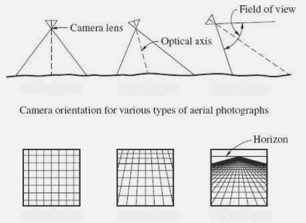
Image from an analogue camera
Photogrammetric workflows [Identification]: No. 1
![<p>Photogrammetric workflows [Identification]: No. 1</p>](https://knowt-user-attachments.s3.amazonaws.com/d3a7deca-3de0-41b1-83c9-82b84db3c34d.png)
Scanning
Photogrammetric workflows [Identification]: No. 2
![<p>Photogrammetric workflows [Identification]: No. 2</p>](https://knowt-user-attachments.s3.amazonaws.com/7ab1a03d-fcf3-4271-a4c7-5de3a28d5ea5.png)
Scanning involves scanning paper and converting it to digital format
Scanning involves scanning _______ and converting it to _________ format
Measurement of the interior orientation
Photogrammetric workflows [Identification]: No. 3
![<p>Photogrammetric workflows [Identification]: No. 3</p>](https://knowt-user-attachments.s3.amazonaws.com/ade74b69-2b88-4fb4-a1f5-37b61d2d6be6.png)
interior geometry
Interior orientation refers to the ____________ of camera
focal length, focal point and lens orientation
The interior geometry of a camera comprises the ________, _________ and ________
Calibration
Photogrammetric workflows [Identification]: No. 4
![<p>Photogrammetric workflows [Identification]: No. 4</p>](https://knowt-user-attachments.s3.amazonaws.com/b55ad27f-26d7-40dd-8a0d-8672f08ddb7d.png)
Images from a digital camera
Photogrammetric workflows [Identification]: No. 5
![<p>Photogrammetric workflows [Identification]: No. 5</p>](https://knowt-user-attachments.s3.amazonaws.com/02d56cac-6120-470c-bf98-b530bb442169.png)
Measurement of the exterior orientation
Photogrammetric workflows [Identification]: No. 6
![<p>Photogrammetric workflows [Identification]: No. 6</p>](https://knowt-user-attachments.s3.amazonaws.com/3849ef15-8434-4254-8107-d01d09c6ea21.png)
3D Dimension of camera
Exterior orientation is the ___________ of ______ at the time of exposure or position
To project or relay the camera to the ground as the camera and the ground have the same axes for uniformity purposes
Why is exterior orientation needed?
Image co-ordinate measurement (ATM)
Photogrammetric workflows [Identification]: No. 7 & 8
![<p>Photogrammetric workflows [Identification]: No. 7 & 8</p>](https://knowt-user-attachments.s3.amazonaws.com/4c1bcda1-1a98-4c94-8389-a97a316a6609.png)
Aerotriangulation / block adjustment
Photogrammetric workflows [Identification]: No. 9 & 10
![<p>Photogrammetric workflows [Identification]: No. 9 & 10</p>](https://knowt-user-attachments.s3.amazonaws.com/1283b52f-8a98-4048-b33c-795a81467ba6.png)
Aerotriangulation
It’s the process of using photos taken from different angles and figuring out the exact location of each point in those photos
block adjustment
It is a process used in aerial surveying and photogrammetry to correct and refine the positions of multiple photos or images, making sure they all align properly and accurately when creating a map or 3D model.
Model definition
Photogrammetric workflows [Identification]: No. 11
![<p>Photogrammetric workflows [Identification]: No. 11</p>](https://knowt-user-attachments.s3.amazonaws.com/a92f0fb3-8767-40d6-a249-ba881036ecaf.png)
Surface models
Photogrammetric workflows [Identification]: No. 12
![<p>Photogrammetric workflows [Identification]: No. 12</p>](https://knowt-user-attachments.s3.amazonaws.com/a959bada-2111-4a1a-b834-f4cdb8e1a2ae.png)
Contour lines, 3D views and more
Photogrammetric workflows [Identification]: No. 13 & 14
![<p>Photogrammetric workflows [Identification]: No. 13 & 14</p>](https://knowt-user-attachments.s3.amazonaws.com/437e5e8d-2239-4a68-9a1c-2b3d61fc7824.png)
Vector data
Photogrammetric workflows [Identification]: No. 15
![<p>Photogrammetric workflows [Identification]: No. 15</p>](https://knowt-user-attachments.s3.amazonaws.com/48c65567-be41-438c-9f82-f7dbdb7550e6.png)
Digitizing
A process that turns image data into vector data
Ortho images
Photogrammetric workflows [Identification]: No. 16
![<p>Photogrammetric workflows [Identification]: No. 16</p>](https://knowt-user-attachments.s3.amazonaws.com/08c1a529-42fd-49bb-9c5a-288a706346a1.png)
Ortho images
Photos rectified for factors such as but not limited to atmospheric refraction
Mosaics
Photogrammetric workflows [Identification]: No. 17
![<p>Photogrammetric workflows [Identification]: No. 17</p>](https://knowt-user-attachments.s3.amazonaws.com/82ee3358-f79c-4676-b3f4-170e59ada200.png)
mosaic
Overlaps are needed to create a ________ such as intersections or building edges or corner monuments like BLLM
Post processing in GIS
Photogrammetric workflows [Identification]: No. 18
![<p>Photogrammetric workflows [Identification]: No. 18</p>](https://knowt-user-attachments.s3.amazonaws.com/c43365d1-de75-4f60-9a3a-36c31e37d188.png)
topographic maps
Principle application of photogrammetry lies in the production of ___________
line maps and orthophoto maps
Topographic maps created using photogrammetry as in the form of both ________ and _________
3D-digitizers
In photogrammetry, photogrammetric instruments function as ____________
digital topographic model
In a photogrammetric analysis, a ___________ is formed which can be visualized with the aid of computer graphics
Earthworks (cut or fill) and flood risk assessment
Example analysis methods of topographic model
Form and the usage of the surface of the Earth
What are stored in such a digital topographic model?
topographical information system
The digital topographic models are input in a _________________ as the central body of data
natural landscape and the cultural landscape
The inputting of the digital topographic models in a topographical information system provides information about both the _______________ and the ______________ (as fashioned by man)
Geoinformation system (GIS)
A topographic information system is a fundamental subsystem in a comprehensive _______________
geodata
Photogrammetry delivers ____________ to a GIS
Close range photogrammetry
______________ is used for architectural recording; precision measurement of building sites and other engineering subjects; surveillance of buildings and documentation of damage to buildings; measuring up of artistic and engineering models; deformation measurement; survey of moving processes, biometric applications; reconstruction of traffic accidents and very many others
Building site (and other engineering subjects) precision measurement
Biometric applications
Building surveillance and
Damage documentation
Artistic and engineering model measurement
Survey of moving processes
Traffic accident reconstruction
Architectural recording
Close range photogrammetry can be used for: 3BDASTA
Robotics
An example of moving processes
Computer controlled surgical operations
An example of biometric applications
Photography
Which means “drawing with light,” originated long before cameras and lightsensitive photographic films came into use.