Unit 4 – Earth Systems & Resources | Fall Semester Exam (copy)
1/36
There's no tags or description
Looks like no tags are added yet.
Name | Mastery | Learn | Test | Matching | Spaced | Call with Kai | Chat |
|---|
No analytics yet
Send a link to your students to track their progress
37 Terms
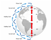
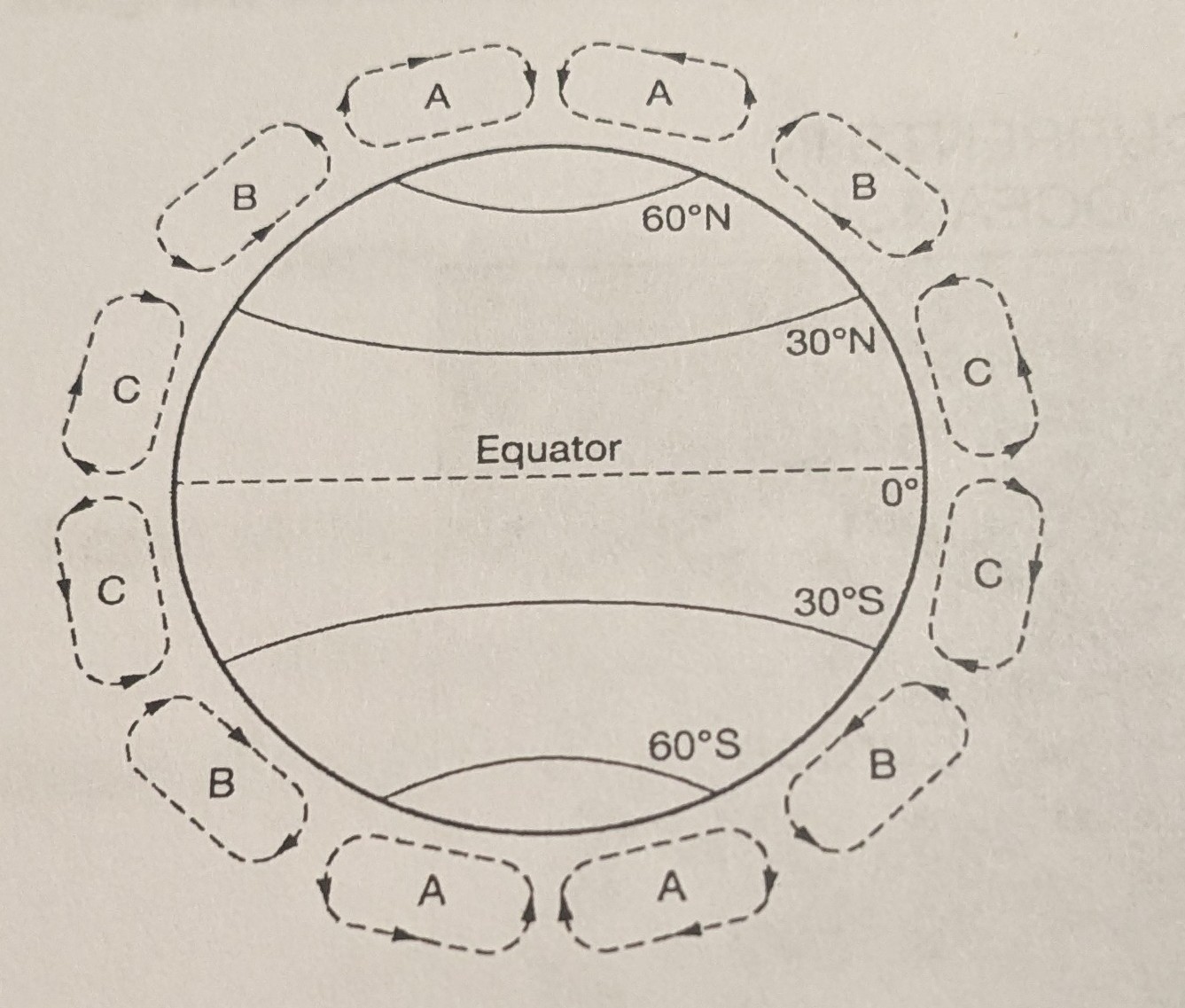
Which of the following causes the air to rise high into the atmosphere in the areas labeled A, B, and C on the diagram shown below? (the circles
El nino circulation patterns
Warm moist air that is less dense than the surrounding air
Rotation of the earth shifting the direction of the air upward
Rain shadows over mountain ridges
Warm moist air that is less dense than the surrounding air
El nino and la nina are natural phenomena associated with changing water temperatures in the pacific ocean. The occurrence of these events can result in changes in global weather and ocean circulation patterns. Which of the following changes in eastern pacific ocean food webs is typically associated with La Nina events?
Decreased populations of anchovies
Increased phytoplankton concentrations
Decreased populations of squid
Increased famine among sea lions and seals
Increased phytoplankton concentrations
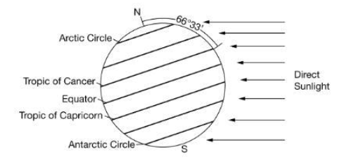
The axis of Earth in relation to the Sun is tilted at a 23.5 degree slant, as illustrated in the diagram below. Use the diagram to answer the next question. If the diagram illustrates earth’s relative position on December 21 of a given year, which of the following statements would be correct?
The tropic of cancer has a shorter day and lower solar radiation intensity because there is a direct relationship between day length and radiation intensity
The equator has twelve hours of daylight and the greatest solar radiation intensity because there is no direct relationship between day length and radiation intensity
The tropic of capricorn has a shorter day and higher solar radiation intensity because there is a direct relationship between length of day and radiation intensity
The tropic of cancer has a shorter day and higher solar radiation intensity because there is an inverse relationship between length of day and radiation intensity
The tropic of cancer has a shorter day and lower solar radiation intensity because there is a direct relationship between day length and radiation intensity
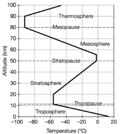
The graph shows the altitude and temperature for different layers of earth's atmosphere. Based on the diagram, which of the following identifies a characteristic to the atmosphere between the stratopause and the tropopause?
The warmest air is found in the mesosphere
The troposphere is the closest layer to the sun
Cloud formation occurs in the stratosphere
The ozone layer is in the stratosphere
Cloud formation occurs in the stratosphere
Which layer of the Earth’s atmosphere has the highest density of any atmosphere layer and contains most of the water vapor in the atmosphere
Stratosphere
Mesosphere
Thermosphere
Troposphere
Troposphere
Which of the following best explains why the lower portion of the troposphere is warmer than the upper portion
The lower portion of the troposphere is separated by the ozone layer from the upper portions, so the lower portion absorbs more sunlight, increasing the temperature
The air in the lower portion of the troposphere is less dense than the air in the upper portion, leading to a higher temperature in the lower portion
The surface of earth absorbs sunlight, heating the lower portion of the troposphere more than the upper part
The troposphere is the highest layer of the atmosphere, so the lower portion is warmed more than the upper part by rising air
The surface of earth absorbs sunlight, heating the lower portion of the troposphere more than the upper part
Which layer of the earth’s atmosphere contains the protective ozone layer that absorbs the sun’s ultraviolet rays
Stratosphere
Troposphere
Thermosphere
Mesosphere
Stratosphere
Most deserts on earth are located near the 30 north and 30 south latitudes because humidity is lower at 30. The best explanation for the lower humidity is that
Rain shadow effects are most pronounced at 30 latitude
Trade winds transfer moisture away from 30 latitude
Cool air rises at 30 latitude, warms, and sinks at the equator
Warm air rises at the equator, cools, and sinks at 30 latitude
Warm air rises at 90 latitude, cools, and sinks at 30 latitude
Warm air rises at the equator, cools, and sinks at 30 latitude
An environmental engineer wants to examine the permeability of different soils to determine the best natural containment system to protect groundwater from pollutants. The engineer tests four different soil samples, places them into a wet column, and pours 50mL of water over each sample. The engineer records the total amount of water that moves through the column as well as the total amount of time for the water to fully percolate through the soil. The data from the study are shown below. Which of the following best describes the independent variable in this research design?
Sample | Flow Time (seconds) | Total Volume of Water Recovered (mL) | Permeability of Soil Sample (mL/sec) |
1 | 2.7 | 43.5 | 17.96 |
2 | 2.2 | 27.9 | 12.63 |
3 | 15.8 | 14.7 | 0.93 |
4 | 20.6 | 1.9 | 0.09 |
The sample of material chosen as the potential container material i the variable being tested, so it is the independent variable
The permeability of each soil sample, which is determined by dividing the total volume of water recovered by the flow is the variable that is calculated so it is independent variable
The flow which is related to the porosity of each sample is a variable that is measured so it is the independent variable
The total volume of water recovered is most likely to be affected by human error and is a variable with the largest range of values so it is the independent variable
The sample of material chosen as the potential container material i the variable being tested, so it is the independent variable
Which of the following best describes where the engineer chose to calculate the permeability of the soil sample in the experimental design in order to evaluate a natural containment system to protect groundwater?
soils that have high permeability would best help protect groundwater because they have higher rates of nutrient and pesticide leaching
soils that have high permeability with best help protect groundwater because they would allow for faster recharge of the aquifer
Soil that have low permeability would best help protect groundwater because the soil traps pollutant so that chemical and biological breakdown
Soils that have low permeability would best help protect groundwater because the large pore spaces would provide space for pollutants to attach and would have rapid percolation of water
Soil that have low permeability would best help protect groundwater because the soil traps pollutant so that chemical and biological breakdown

Select the choice that best fits each statement. The following questions refer to the soil composition diagram below. which soil composition would be the best choice for lining a landfill
Point U
Point T
Point W
Point V
Point X
Point W
What are the proportions of sand, silt, and clay for the soil at point T?
65-25-10
75-20-5
70-20-10
55-30-15
60-30-10
60-30-10
Which of the following does NOT exert a major influence on Earth’s overall climate?
The distribution of land masses and oceans, in combination with Earth's topography
The daily rotation of Earth on its axis, and its annual revolution around the Sun
The concentrations of the specific gases in Earth’s atmosphere
The annual amount of solar radiation that reaches the Earth’s surface
The seasonal development of temperature inversions in geographical basins
The seasonal development of temperature inversions in geographical basins
Which of the following best explains why City B regularly receives less precipitation than City A? Starting from here, form B
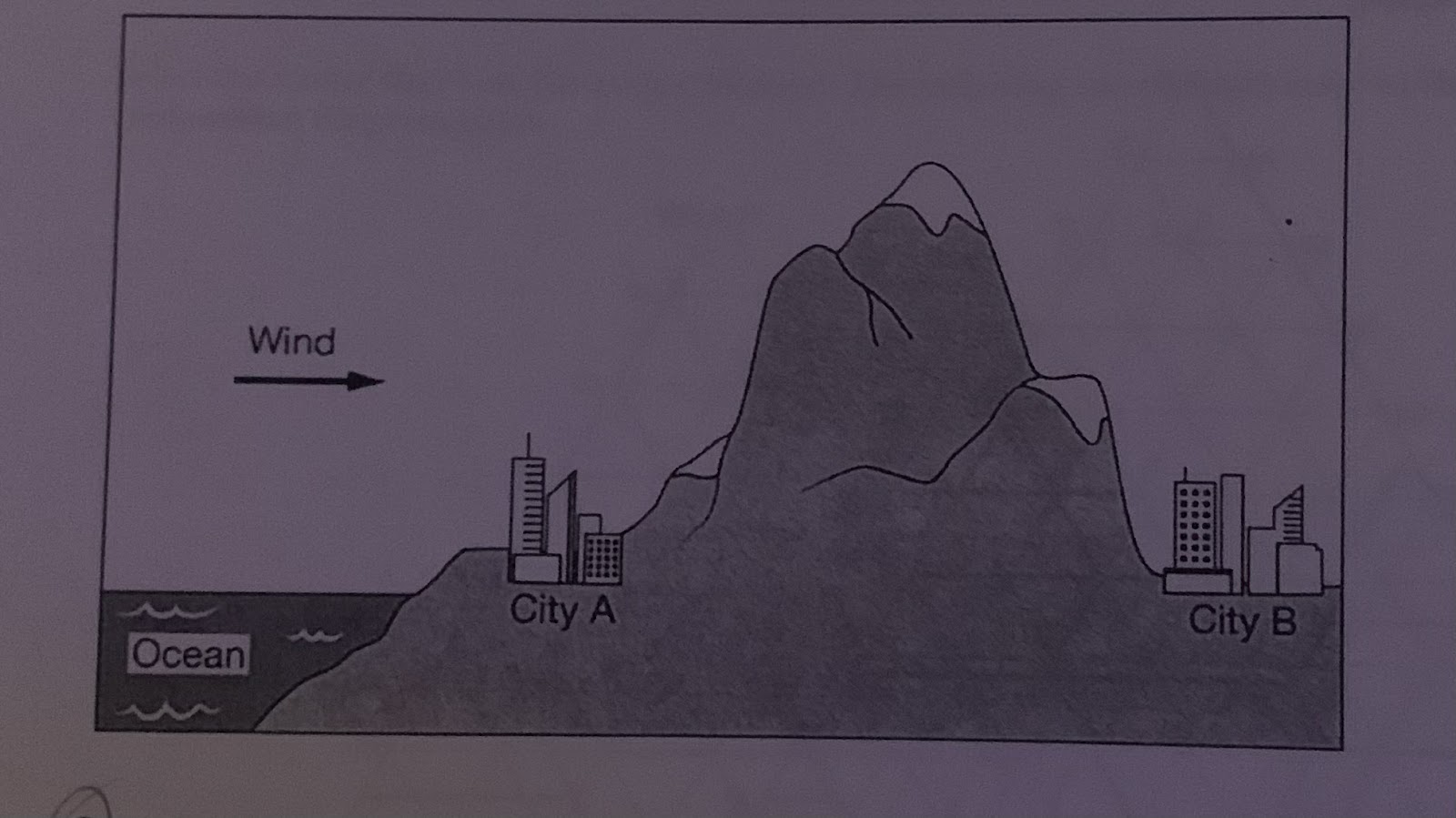
As air rises up the side of the mountain near City B, the temperature and the relative humidity increase, causing increased precipitation on the other side of the mountain over City A.
The rain shadow effect causes City B to be drier because the mountain blocks precipitation from reaching the city.
Air that is forced upward on the side of the mountain near City B leads to the formation of stratospheric clouds
The Urban heat island from City B causes a warmer climate that leads to reduced cloud formation.
The rain shadow effect causes City B to be drier because the mountain blocks precipitation from reaching the city.
Which of the following is a biome found at 30N and 30S as seen in the diagram
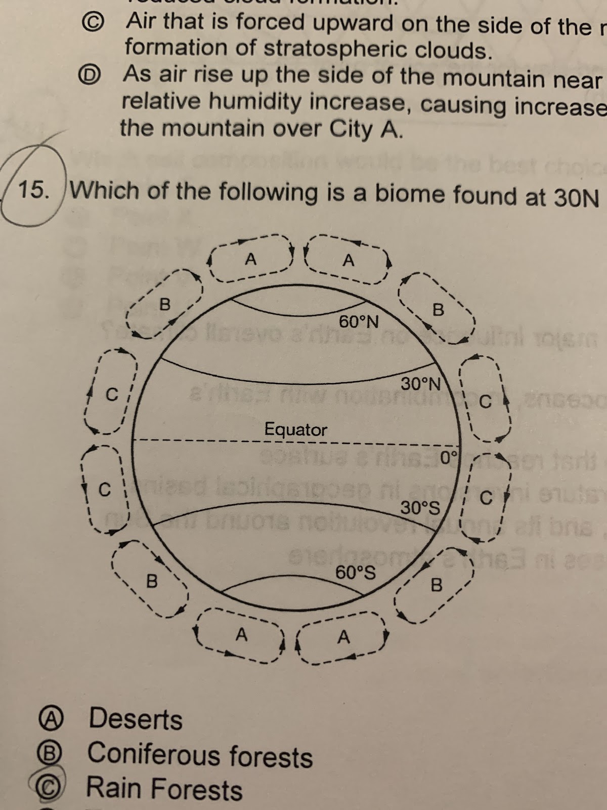
Coniferous forests
Deserts
Tundras
Rainforests
Deserts
Which of the following best describes why understanding a watershed and its boundaries is important in designing housing developments along a river?
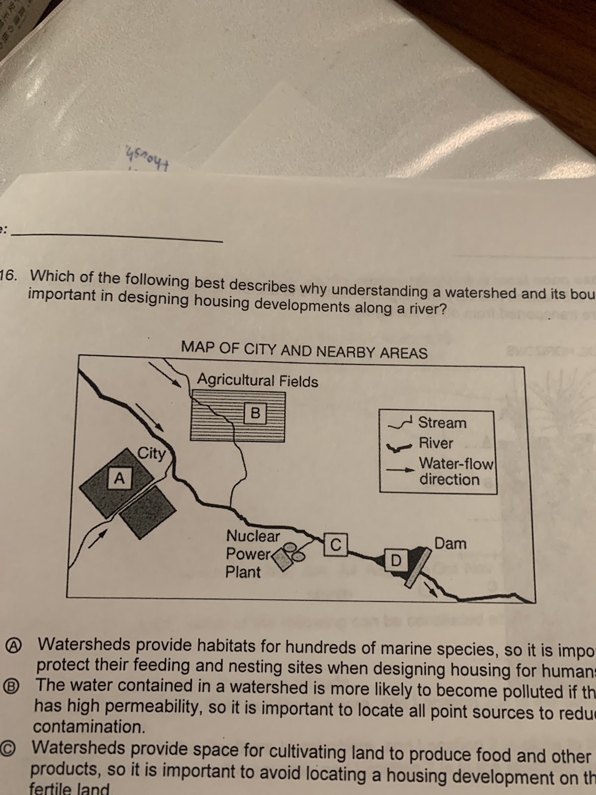
Watersheds provide habitats for hundreds of marine species, so it is important to protect their feeding and nesting sites when designing housing for humans.
The water contained in a watershed is more likely to become polluted if the soil has high permeability, so it is important to locate all point sources to reduce contamination
Watersheds provide space for cultivating land to produce food and other products, so it is important to avoid locating a housing development on the most fertile land.
Surface water and stormwater runoff will drain downstream within the watershed boundaries, so it is important to understand the flow of water through the watershed.
Surface water and stormwater runoff will drain downstream within the watershed boundaries, so it is important to understand the flow of water through the watershed.
Which statement is the best explanation of acid precipitation?
Acid precipitation causes chemical weathering, which can consume key soil nutrients from breaking up rock.
Acid precipitation causes physical weathering, which can release key soil nutrients from breaking up rock
Acid precipitation causes chemical weathering, which can release key soil nutrients from dissolving minerals in rock
Acid precipitation causes physical weathering, which can consume key soil nutrients from dissolving minerals in rock
Acid precipitation causes chemical weathering, which can release key soil nutrients from dissolving minerals in rock
Which Soil horizon has very little organic matter and accumulates soluble metals and nutrients that are transported from other soil layers?
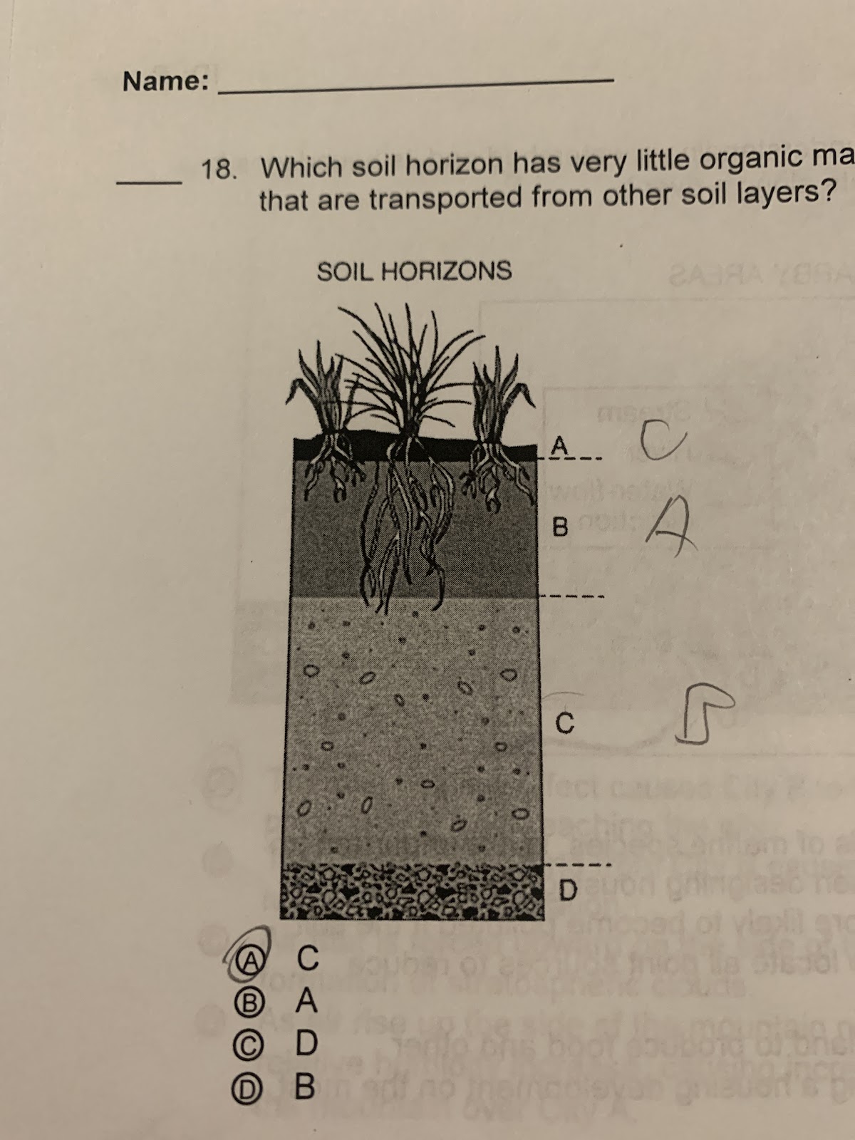
D
A
B
C
D
During an El Nino-Southern Oscillation event, which of the following best describes conditions in the eastern part of the tropical Pacific Ocean(e.g., near Peru and Ecuador)
Sea surface temperature is LOW and Rainfall is HIGH
Sea surface temperature is HIGH and Rainfall is HIGH
Sea surface temperature is HIGH and Rainfall is NORMAL
Sea surface temperature is LOW and Rainfall is LOW
Sea surface temperature is HIGH and Rainfall is LOW
Sea surface temperature is HIGH and Rainfall is HIGH
The graph below shows the relative solar energy received at local noon each day of the year at two different locations. 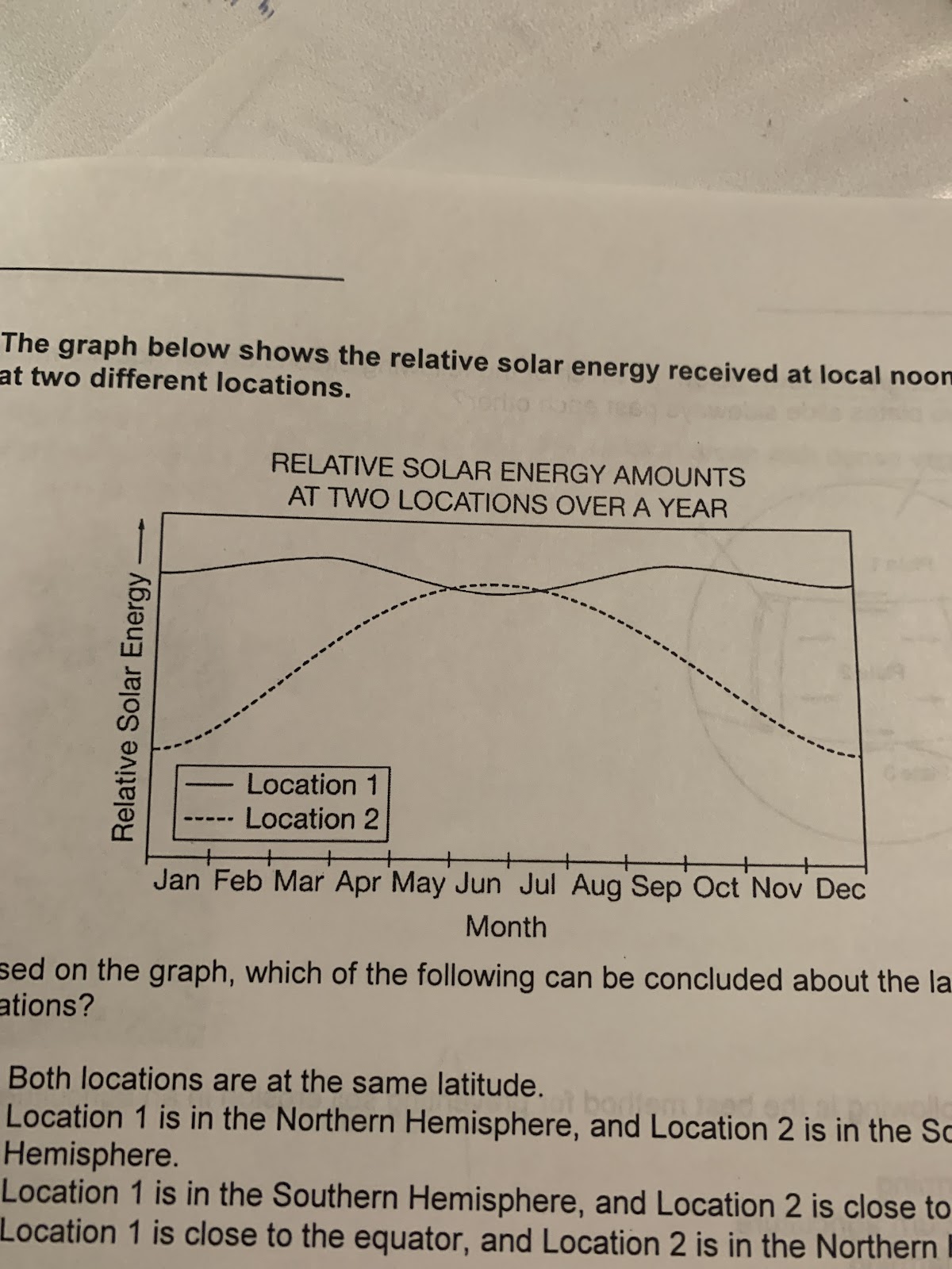
Based on the graph, which of the following can be concluded about the latitudes of the two locations?
Both locations are at the same latitude
Location 1 is in the Northern Hemisphere, and Location 2 is in the Southern Hemisphere.
Location 1 is in the Southern Hemisphere, and Location 2 is close to the equator
Location 1 is close to the equator, and Location 2 is in the Northern Hemisphere
Location 1 is close to the equator, and Location 2 is in the Northern Hemisphere
Regenerative agriculture (“Kiss the Ground” documentary) focuses on improving the health of soil which has been degraded by the use of heavy machinery, fertilizers, and pesticides in intensive farming. Which is NOT a part of the regenerative agricultural movement?
Food waste composting
Hooded animal roaming freely
Soil carbon sequestration
Atmospheric carbon drawdown
non-GMO crops
non-GMO crops
Look at the diagram shown below. At which of the following sites is an earthquake most likely to occur as two plates slide sideways past each other?

A
D
C
B
C
Which of the following is the best method for preventing soil erosion in an agricultural area?
Terrace farming
Slash-and-Burn agriculture
Monocrop farming
Integrated pest management
Terrace farming
What are the five primary soil formation factors?
Climate, parent material, topography, organisms, time
Climate, parent material, pH, organisms, topography
Parent material, topography, organisms, time latitude
Parent material, climate, pH, latitude, altitude
Climate, parent material, topography, organisms, time
Which soil horizon is best developed in areas with dense vegetation, such as forests and grasslands?
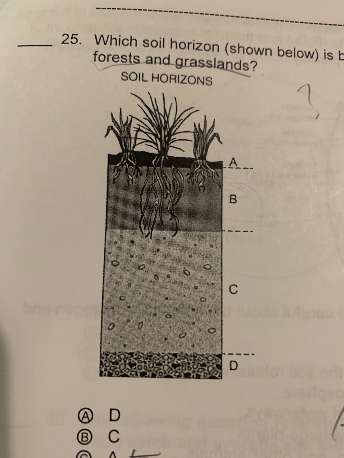
A
D
C
B
A
The city of London in the United Kingdom is found approximately at the same latitude as the city of Calgary in Canada. Calgary has an average temperature of in December of -4.6°C while London has an average high temperature of 8.6°C. Which of the following statements best explains why the average temperature of London is warmer than that of Calgary in December
London is farther from the north pole than Calgary is
Oceanic currents warm the atmosphere in London
The solar radiation reaching London is more perpendicular than the solar radiation that reaches Calgary in December
The Hadley saw converges over London and pushes warm air towards the surface
Oceanic currents warm the atmosphere in London
all fertilizers have three small numbers on their container. The first number is the amount of nitrogen and the second number is the amount of phosphate and the third number is the amount of potash. These numbers represent the primary nutrients needed in soil- nitrogen, phosphorus, and potassium.
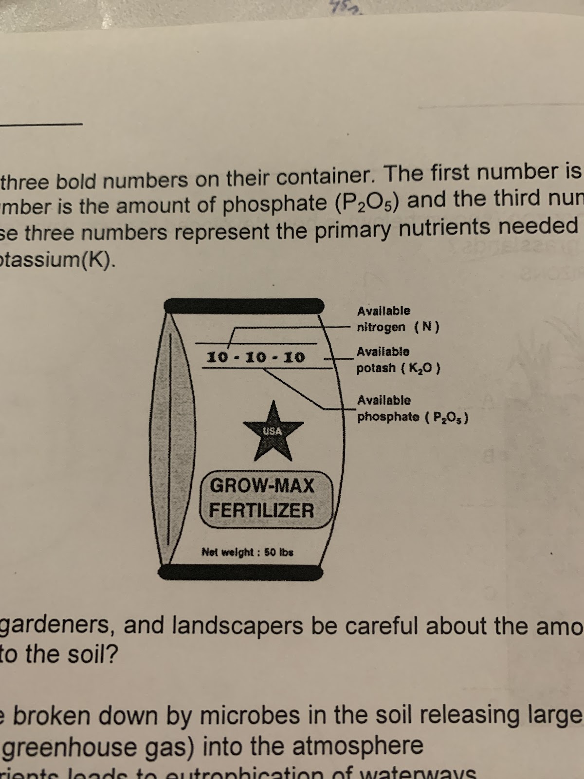
Why should farmers, gardeners, and landscapers be careful about the amount of nitrogen and phosphorus they add to the soil?
These nutrients are broken down by microbes in the soil, releasing large amount of nitrous oxide, a greenhouse, gas into the atmosphere
These nutrients are harmful to pets, small children, and other animals
Runoff of these nutrients leads to eutrophication of waterways
These nutrients can raise the pH of soil and damage plants
Runoff of these nutrients leads to eutrophication of waterways
Which latitude shown on the diagram below experiences 24 hours of daylight on December 21?
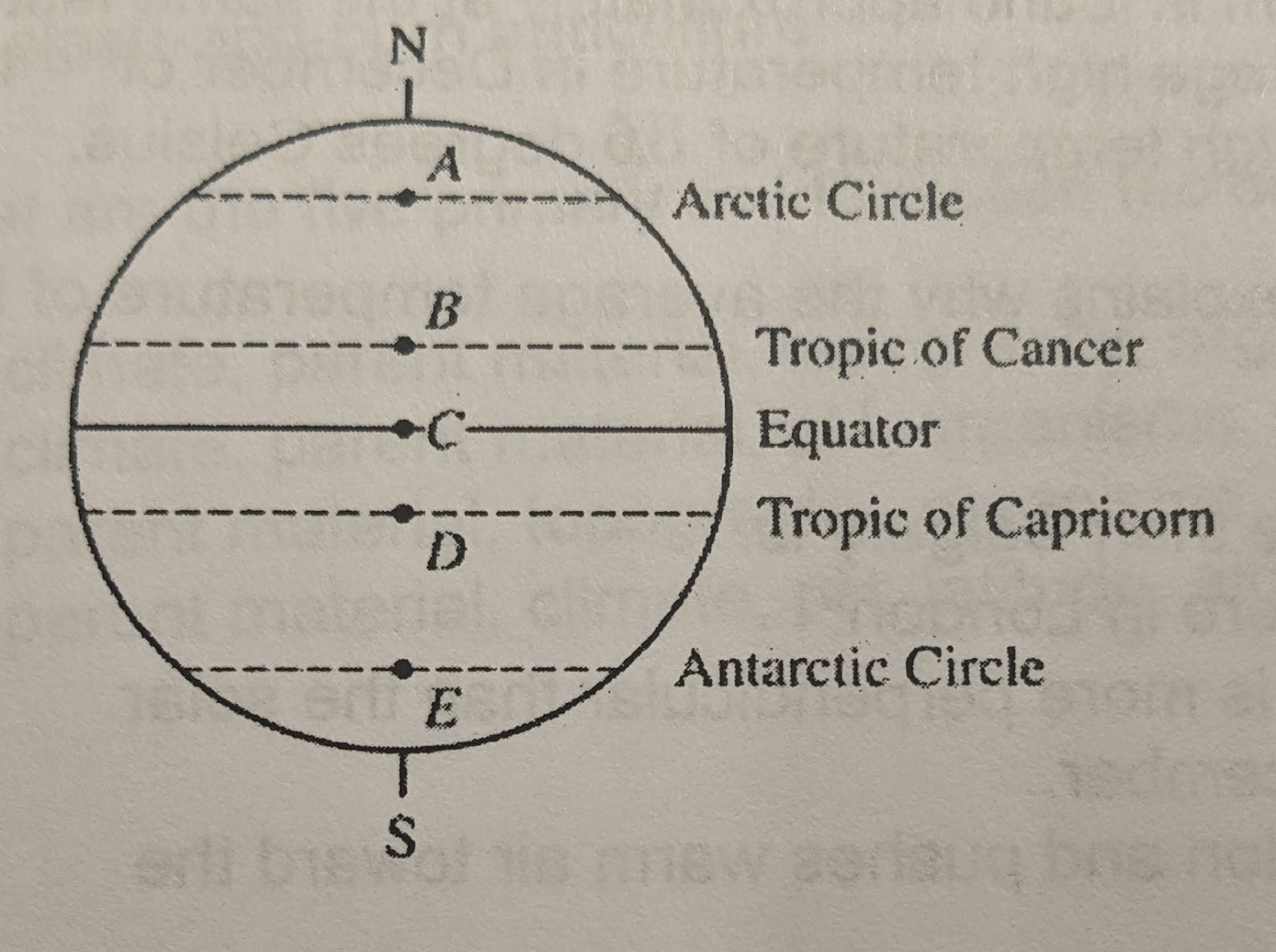
B
C
D
E
A
E
refer to the diagram below. At which of the following sites would activity result in volcanoes, island arcs, and mountains?
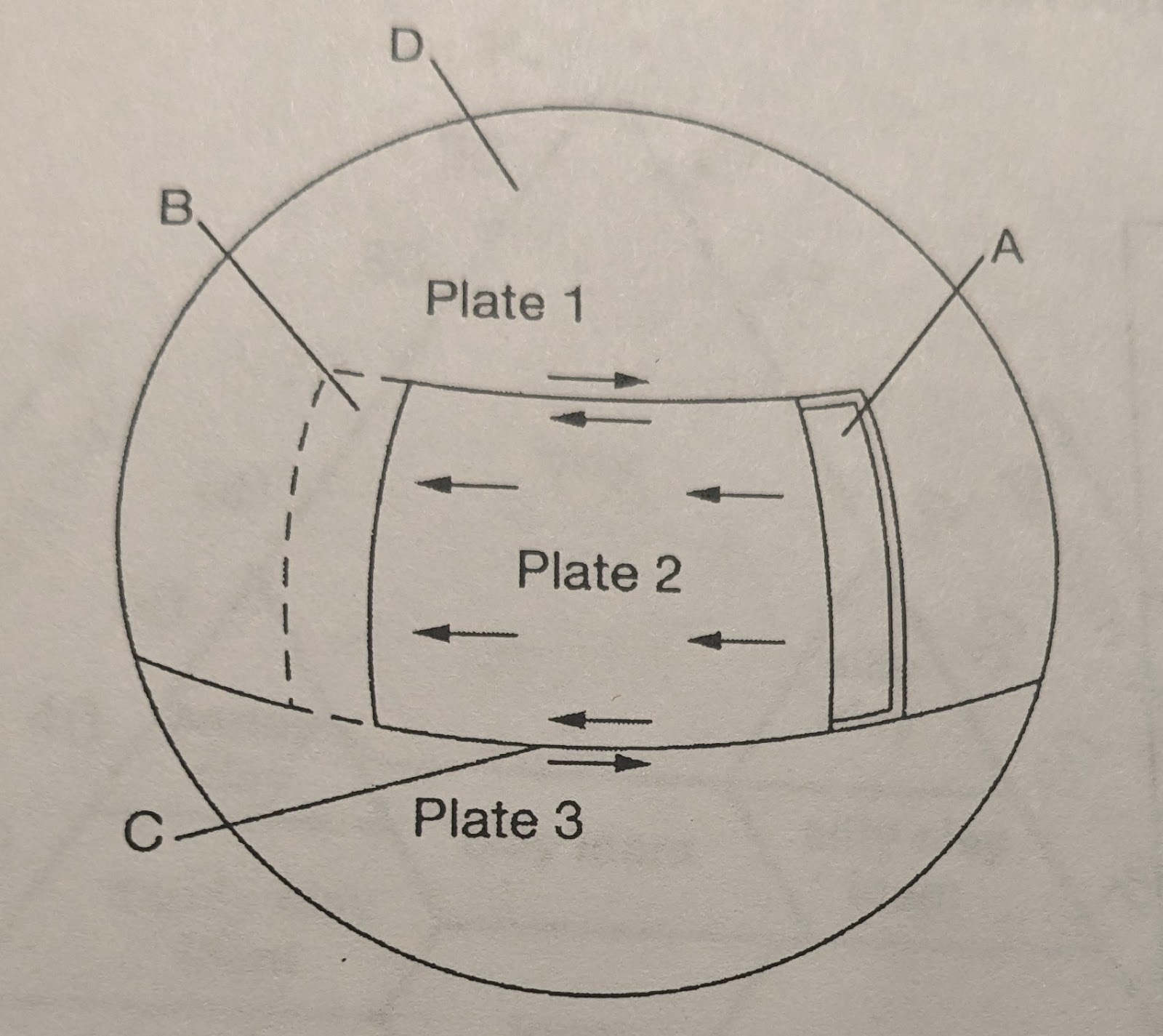
C
B
A
D
B
The low anchovy catch in 1998 was most likely the result of
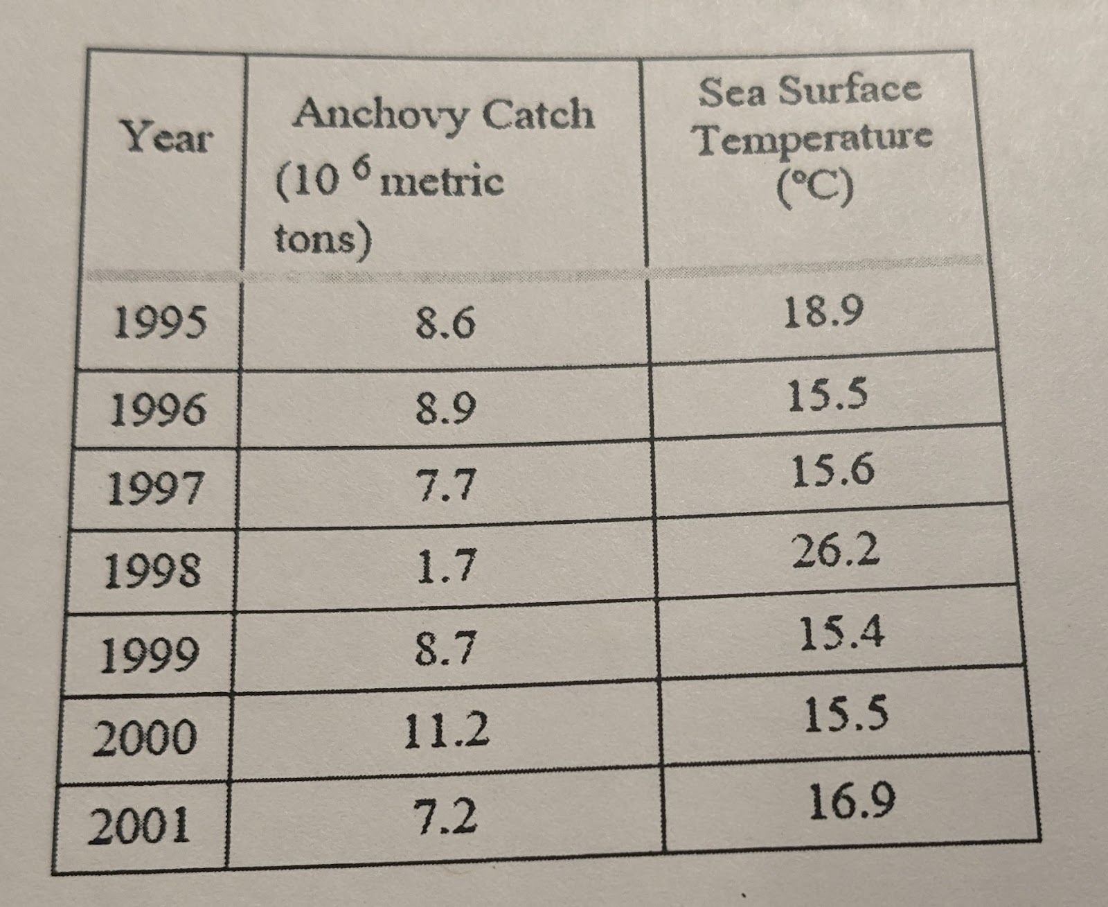
Reduced ocean upwelling along the coast
An increase in the population of anchovy predators
An increase in the number of hurricanes
Unusually strong trade winds
Reduced surface runoff due to drought
Reduced ocean upwelling along the coast
The high sea surface temperature in 1998 was most likely due to
Salinization
Global warming
Eutrophication
Pacific Northern Annual Oscillation
El Nino
El Nino
Corn is a crop that grows best in soil that drains well. Which of the following soil is best suited to grow corn?
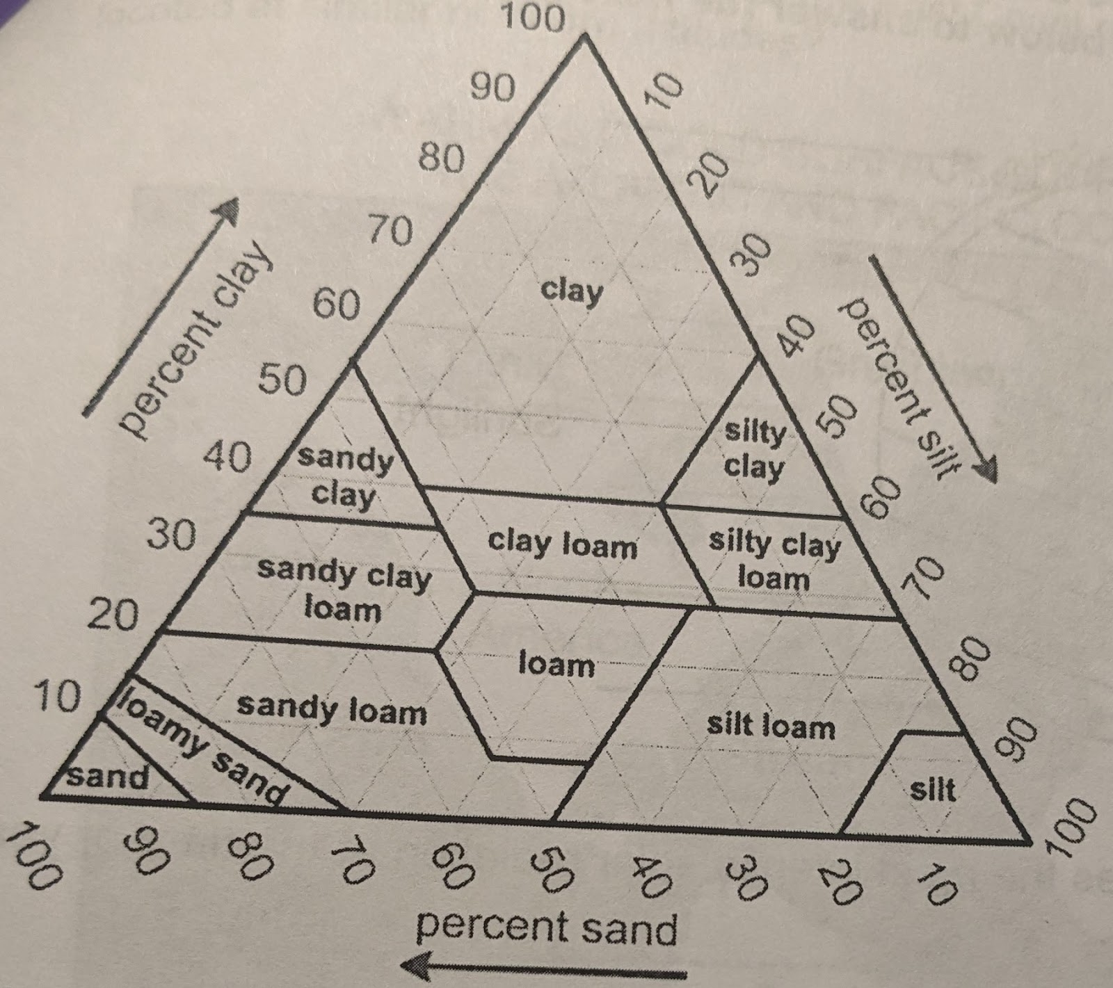
Silty clay loam because it has all three soil components
Silt loam because it is about 80% silt and has low amounts of sand
Sandy loam because it has a large amounts of sand and less than 20% clay
Clay loam because it has at least 40% clay so it absorbs water very well
Sandy loam because it has a large amounts of sand and less than 20% clay
Which of the following areas receives the most intense solar radiation at the time of year shown in the diagram above, and why?
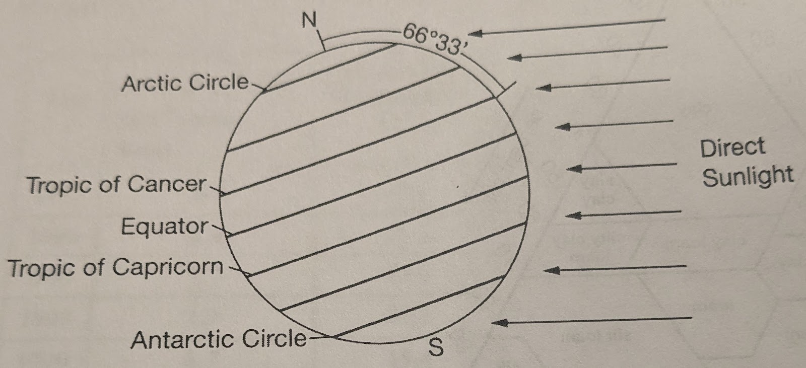
The Tropic of Capricorn, because this latitude is nearly horizontal to incoming solar radiation
The equator, because it is the hottest region and therefore receives the most intense solar radiation
The Tropic of Cancer, because solar radiation spreads out over a wider area at this latitude
The Antarctic Circle, because it is the closest to the Sun
The Tropic of Cancer, because solar radiation spreads out over a wider area at this latitude
The primary cause of Earth's seasons is the
Constant tilt of Earth's rotational axis with respect to the plane of its orbit around the sun
Changing distance of Earth from the Sun at different times of the year
Periodic wobbling of Earth on its axis of rotation
Changing relative positions of Earth, its Moon, and the Sun
Periodic changes in solar energy output
Constant tilt of Earth's rotational axis with respect to the plane of its orbit around the sun
Based on the diagram, which of the following statements best explains why the climate of the West Coast of Africa is drier than that of the East Coast of the United States, even though they are located at similar northern latitudes?
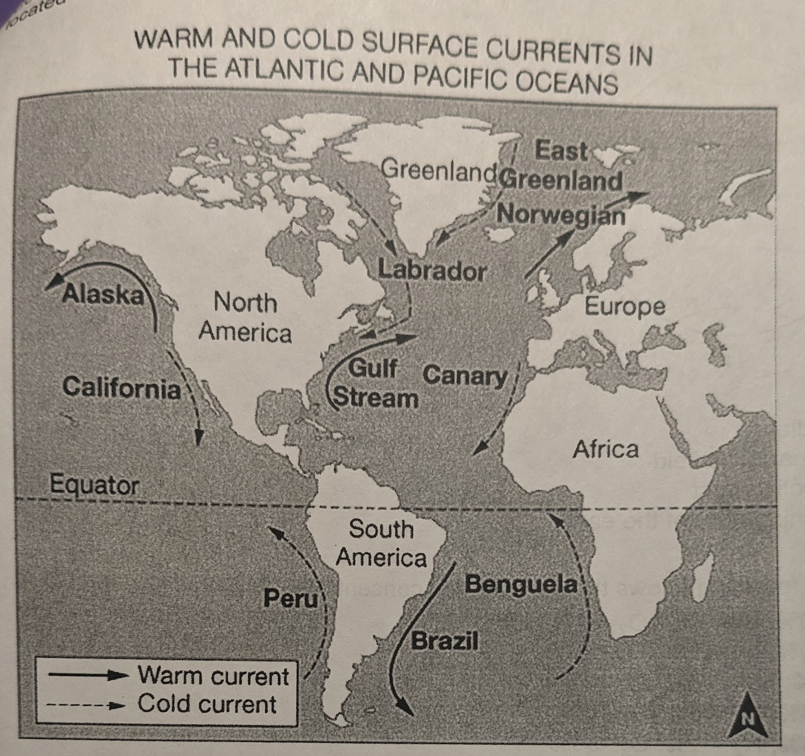
The cold ocean currents evaporate more easily, releasing latent heat into the atmosphere
The warm ocean currents off the United States flow east, making the atmospheric temperatures warmer in Africa
The cold ocean currents off Africa absorb heat from land and therefore cool the atmosphere
Africa is closer to the Equator, which makes the temperatures warmer
The cold ocean currents off Africa absorb heat from land and therefore cool the atmosphere
Which of the following is the source of energy driving the circulation pattern labeled C in the diagram?
Solar radiation
Earth's magnetic field
The Coriolis effect
The spinning core of the earth
Solar radiation
Which of the following shows the approximate concentration of CO2, N2, and O2 in dry air?
CO2 = 78%; N2 < 1%; O2 = 21%
CO2 = 10%; N2 = 70%; O2 = 20%
CO2 < 1%; N2 = 78%; O2 = 21%
CO2 = 36%; N2 = 8%; O2 = 56%
CO2 = 43%; N2 < 1%; O2 = 56%
CO2 < 1%; N2 = 78%; O2 = 21%