Human Geography Unit 6 Vocabulary
1/100
Earn XP
Description and Tags
Name | Mastery | Learn | Test | Matching | Spaced | Call with Kai |
|---|
No analytics yet
Send a link to your students to track their progress
101 Terms
City
A relatively large, densely populated settlement with a much larger population than rural towns and villages; cities serve as important commercial, governmental, and cultural hubs for their surrounding regions
Urban
Relating to a city
Urbanization
The movement of people from rural areas to cities
Agricultural surplus
Crop yields that are sufficient to feed more people than the farmer and his or her family
Socioeconomic stratification
The structuring of society into distinct socioeconomic classes, including leadership (for instance, a government or ruling class) that exercise control over goods and people
First urban revolution
The agricultural and socioeconomic innovations that led to the rise of the earliest cities
Urban hearth areas
Regions in which the world’s first cities evolved
Site
An absolute location of a place on Earth
Situation
The relative location of a place in reference to its surrounding features, or its regional position with reference to other places
Capitalism
An economic and political system in which a country’s trade and industry are controlled by private owners for profit rather than owned and run by the state
Communism
An economic and political system in which all property is publicly owned and managed
Streetcar suburb
A settlement outside of a city with streetcar lines; the streetcars take residents into and out of the city easily
Second urban revolution
The industrial innovations in mining and manufacturing that led to increased urban growth
Redevelopment
A set of activities intended to revitalize an area that has fallen on hard times
Metropolis
A very large and densely populated city, particularly the capital or major city of a country or region
Urban area
Any self-governing place i the United States that contains at least 2500 people
Urbanized area
In the United States, an urban area with 50000 people or more
Urban cluster
In the United States, an urban area with fewer than 50000 inhabitants
Metropolican statistical area
In the United States, a region with at least one urbanized area as its core
Micropolitan statistical area
In the United States, a region with one or more urban clusters of at least 10000 people as its cores
Suburb
A populated area on the outskirts of a city
Urbanizing rate
The percentage of a nation’s population living in towns and cities
Suburbanization
The movement of people from urban core areas to the surrounding outskirts of a city
Sprawl
The tendency of cities of grow outward in an unchecked manner
Automobile cities
Cities whose size and shape are dictated by and almost require individual automobile ownership
Decentralize
In an urban context, to move business operations from core city areas to outlying areas such as suburbs
Edge city
A concentration of business, shopping, and entertainment that developed in the suburbs, outside of a city’s traditional downtown or central business district
Boomburb (also called boomburg)
A place with more than 100000 residents that is not a core city in a metropolitan area; a large suburb with its own government
Infill development
The building of new retail, business, or residential spaces on vacant or underused parcels in already-developed areas
Exurb
A semi rural district located beyond the suburbs that is often inhabited by well-to-do families
World city
A city that is a control center of the global economy, in which major decisions are made about the world’s commercial networks and financial markets (also called a global city)
Gated community
Privately governed and highly secure residential area within the bounds of a city; often has a fence or a gate surrounding it
Urban system
A set of interdependent cities or urban places connected by networks
Urban hierarchy
A ranking of cities, with the largest and most powerful cities at the top of the hierarchy
Rank-size rule
The population of a settlement is inversely proportional to its rank in the urban hierarchy
E.g. the city in the third rank will have a population 1/3 of the city in the first rank, the fourth ranked city would have ¼ the population of the first ranked city, and so on
More common in developed countries rather than developing countries
Primate city
A city that is much larger than any other city in the country that dominates the country’s economic, political, and cultural life
Common in developing countries and countries that were once colonial powers
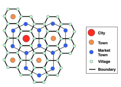
Central place theory
A mode, developed by Walter Christaller, that attempts to understand why cities are located where they area
Assumptions:
The surface or a region is flat with no physical barriers, such as mountain ranges or rivers
Soil quality is the same everywhere
Population and purchasing power are evenly distributed
The region has uniform transportation networks that permit direct travel from each settlement to the others
From any given place, any good or service, can be sold in all direction out to a certain distance
Predictions:
People will travel a certain distance to acquire goods produced by central places
The order of a good determines how far people travel to get it
People are more willing to travel long distances to get higher order goods
Threshold
In central place theory, the number of people required to support business
Central place
A settlement that makes certain types of products and services available to consumers
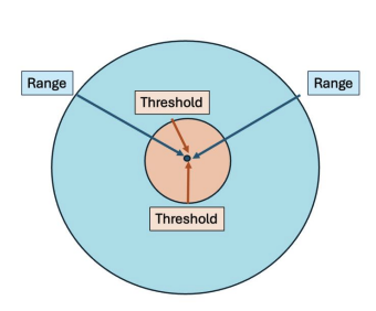
Range
In central place theory, the distance people will travel to acquire a good

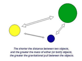
Gravity model
The idea that the closer two places are, the more they will influence each other
The interaction is proportional to the product of the two cities’ populations divided by the square of the distance between them
Interaction = p1*p2/d²
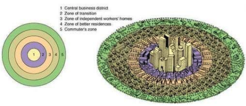
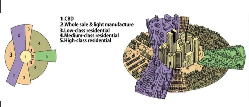
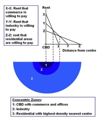
Concentric zone model
A model of a city’s internal organization developed by E. W. Burgess organized five concentric rings that model the arrangement of different residential zones radiating outward from a central business district
The zones are:
Central business district (CBD)
Zone of transition
Zone of independent workers’ homes
Zone of middle-class residences
Commuters’ zone
Findings
Businesses locate in the central business district
The lowest class and immigrants live in the zone of transition, and gradually move outward as they gain income
Landlords allowed housing to deteriorate in anticipation of an expansion of the CBD
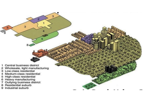
Hoyt model of sector model
A model of a city’s internal organization, developed by Homer Hoyt, that focuses on transportation and communication as the divers of the city’s layout
Zones:
CBD
Manufacturing and industry
Low-income residential
Middle'-income residential
high-income residential
Findings:
People move to higher income residential zones as they gain wealth
The zones expand outward like sectors (or pie slices) from the CBD so almost all zones have some overlap with the CBD
Multiple-nuclei model
A model of a city’s internal organization, developed by Chauncy Harris and Edward Ullman, showing residential districts organized around several nodes (nuclei) rather than one central business district
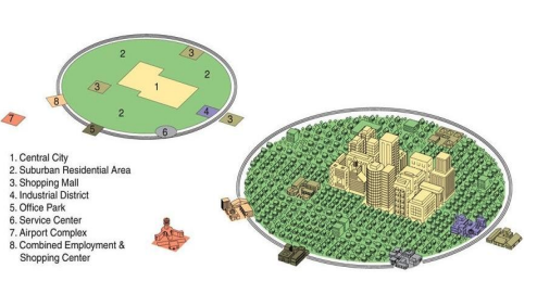
Galactic city model or peripheral model
A model of a city’s internal organization in which the central business district remains central, but multiple shopping areas, office parks, and industrial districts are scattered throughout the surrounding suburbs and linked by metropolitan expressway systems
The city is decentralized
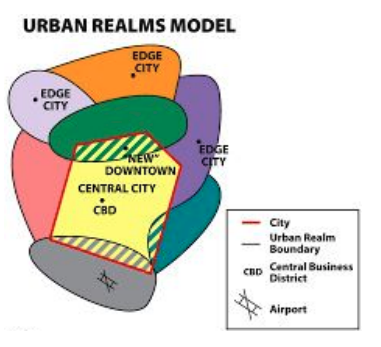
Urban realms model
A model of a city’s internal organization, developed by Vance, in which a city is separated into different realms (sectors) with a different purpose for each. Realms link together to form a larger city and is automobile-dependent so that people can travel around to all the different realms.
Bid-rent theory
Land rent (land value) will decrease as one gets farther away from central markets.
Rent is highest in the closest proximity to urban markets
Griffin ford model for Latin American cities
A model of the internal structure of a Latin American city developed by Ernst Griffin and Larry Ford
A combination of concentric zones and radial sectors
Has a commercial “spine” connecting the CBD to a mall/church, which is flanked by elite residences
Zone of maturity: Rings the CBD/market center and is occupied by the middle classes and contains the best housing outside of the elite sector - also contains a small gentrification sector
Zone of situ accretion: A transitional area between the zone of maturity and the poorest parts of the city
Disamenity sector: A zone that offers very few services and is home to the very poor. They are also known as peripheral squatter settlements and the quality of life here is very poor
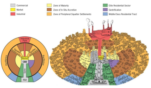
Gentrification
The displacement of lower-income residents by higher-income residents as an area or neighbourhood improves
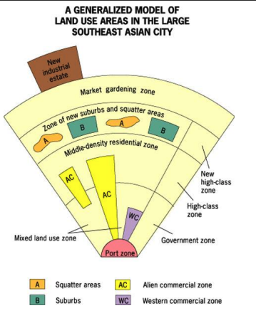
Southeast Asian city model
A model of the internal city structure of Southeast Asian cities by T. G. McGee which has a focal point of a colonial port rather than a CBD.
Zones radiate outwards from the port
Alien commercial zones are populated primarily by Chinese merchants
Squatter settlements and new suburbs are mixed into similar areas
There is also a market gardening zone and a recently built industrial park
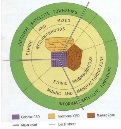
Sub-Saharan Africa City Model
A model of the internal structure of Sub-Saharan African cities by De Blij. The city has three CBDs, the traditional, colonial, and market zone. The colonial CBD is a place for informal markets and is a transitional business center with makeshift stalls. The traditional CBD has one-storey buildings. The market zones is an open air, informal business district. Ethnic neighbourhoods, mining and manufacturing, and squatter settlements and townships circle the CBDs.
Perceived density
The general impression of the estimated number of people present in a given area
Zoning regulations
Laws that dictate how land can be used
Fiscal squeeze
Occurs when city revenues cannot keep up with increasing demands for city services and expenditures on decaying urban infrastructure
Built environment
The human-made space in which people live, work, and engage in leisure activities on a daily basis
Smart growth
Policies that combat regional sprawl by addressing issues of population density and transportation
Compact design
Development that grows up (in the form of taller buildings) rather than out (in the form of urban sprawl)
Diverse housing options
Policy that encourages building quality housing for people and families of all life stages and income levels in a range of prices within a neighbourhood
Mixed land use
The primary driver behind mixed land use is the interspresal of different types of development in a neighbourhood, such as residential, business, and entertainment to bring people to a neighbourhood at a variety of different times
New Urbanism
An approach to city planning that focuses on fostering European-style cities of dense settlements, attractive architecture, and housing of different types and prices within walking distance to shopping, restaurants, jobs, and public transportation.
Mixed commercial/residential areas that are walkable
Greenbelt
A zone of grassy, forested, or agricultural land separating urban areas. Building is restricted in these areas.
Zoning
The classification of land according to restrictions on its use and development
Slow-growth city
A city that changes its zoning laws to decrease the rate at which the city spreads horizontally, with the goal of avoiding the negative effects of sprawl
Anti-displacement tenant activists
Advocates for poor and working-class residents who are at risk of losing their affordable housing to new development
De facto segregation
Racial segregation that is not supported by law but is still apparent
Census
an official count or survey of a population
Survey data
information collected from individuals answering surveys that can be used for statistical analysis.
Field studies
the study of geographic phenomena by visiting places and observing how people interact with and thereby change those places.
Narratives
individuals personal experiences recorded as data.
Disamenity zones
Zones within cities that lack desirable features or infrastructure
Zones of abandonment
Areas within cities that have been deserted for economic or environmental reasons
Mortgage
A loan that is taken out to purchase a home
Redlining
The practice of identifying high-risk neighbourhoods on a city map and refusing to lend money to people who want to buy property in those areas
Blockbusting
The practice of persuading owners to sell property cheaply because of the fear of people of another race or class moving into the neighborhood, and thus profiting by reselling at a higher price.
White flight
The mass movement of white people from the city to the suburbs
Affordability
Unequal treatment when trying to buy, rent, lease, sell or finance a home based on certain characteristics, such as race, gender, and religion.
Housing choice voucher program
A federal government program to assist very low-income families, the elderly, and the disabled with affordable, decent, safe, and sanitary housing
Violent crime
A category of crime that includes murder, rape, robbery, and aggravated assault.
Social controls
Formal or informal institutions that help maintain law and order in a place
environmental justice
Occurs when certain groups carry a larger share of environmental risks and hazards than groups who have the power to influence decisions about the environment
Environmental racism
Occurs when areas inhabited by low-income people of color are targeted for environmental contamination
Environmental justice
The movement to fix environmental discrimination
Squatter settlement
An area of degraded, seemingly temporary, inadequate, and often illegal housing
Land tenure
The right to own or hold property; it defines the ways in which rights to that property area managedIn
Inclusionary zoning (IZ)
Municipal and county planning ordinances that require a gibven share of new construction to be affordable for people with low to moderate incomes
Exclusionary zoning
Zoning that attempts to keep low to moderate income people out of a neighbourhood
NIMBYs
Abbreviation for “not in my backyard”; term for people who try to prevent the construction of affordable housing and other types of development in their neighbourhood
Below market rate housing
Housing that costs much less than the going rate
Urban renewal
Large-scale redevelopment of the built environment in downtown and older inner-city neighbourhoods to increase sense of place
Fiscal imbalance
Occurs when a government must spend more than it receives in taxes
Fiscal zoning
The practice of using local land use regulation to preserve and possibly enhance the local property tax base
Ecological footprint
The total amount of natural resources used and their impact on the natural environment
Urban heat island
A mass of warm air in cities, generated by urban building materials and human activities, that sits over a city
Brownfield
Properties whose use or development may be complicated by the potential presence of hazardous substances or pollutants
Greyfield
Are not contaminated, but have large developed spaces (parking lots, old buildings etc.) that are now unused
Urban footprint
The spatial extent of an urban area’s impacts on the natural environment
Urban risk divide
The idea that disasters and disaster risk become urban phenomena as the world’s population become
Brownfield remidiation
The process of removing or sealing off contaminants so that a site may be used again without any health concerns
Phytoremidiation
The removal of contaminants with plant species that react or degrade contaminants or draw up contaminants from the soil into shoots and leaves
Farmland Protection Policy Act (FPPA)
U. S. law that grants municipalities oversight over federally funded development projects on farmland