Climate/Weather
1/21
Earn XP
Description and Tags
This includes climate and wether vocab for 6/7th graders
Name | Mastery | Learn | Test | Matching | Spaced | Call with Kai |
|---|
No analytics yet
Send a link to your students to track their progress
22 Terms
Layer of our atmosphere closest to earth
Troposphere
The layer of our atmosphere where it’s second closest and weather balloons are in this layer
The stratosphere
The layer of our atmosphere where meteors, meteorites, and shooting stars happen third closest
The mesosphere
The layer of our Earth that is the largest and has satellites and it has a lot to do with temperature.
Thermosphere
Layover atmosphere that is the farthest away from us in rocket kids go through this when our. Has a lot to do with skeletons.
Exosphere
A forecast for the day
Weather
Most cold climate;like the bear
Polar
Warming climate : think florida
Temperate
Very warm and wet
Tropical
Think desert, not wet and hot
Dry
Where we live
Continental
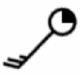
Weather station symbol
This symbol looks like a key and tells you the direction the wind is coming and going as well as how fast its moving, also telling you the cloud coverage for the day.
Trade winds
Trade winds occur between 0-3o degrees latitude, they are steady predictable wins that blow from east to west near the equator.
Prevailing westerlies
Prevailing westerlies are the winds that blow from the west towards the east in the middle of the ocean between about 30 and 60° latitude.
Polar Easterlies
Polar Easter leaves are cold to dry winds that move from the north and south poles towards the equator these winds blow near the top and bottom of the Earth in the Arctic and Antarctic rations from the polls down to about 60° latitude.
High-pressure system
A high-pressure system is generally means good weather, on a map. It is a blue H.
Low pressure system
A low pressure system generally means rainy or cloudy weather on a map. A low pressure system is shown by a red L.
Explain where clouds form and why in a warm front
Add a warm front, one air gently slide up and over the cooler air which causes clouds to form gradually over a larger area.
Explain where clouds form and why in a cold front.
Add a cold front, a fast moving dense, cold air mass pushes warm air up and over it creating tall and stormy clouds.
Warm front
A warm air front mass replaces a cold one often bringing rain and clouds. It is represented by red lines on a weather map.
Cold fronts
A cold front is where a cold air mass is replacing a warm air mass. The temperature will likely drop in the weather changes rapidly. It is represented by blue lines on a weather map.