3 - Hazardous environments
1/32
There's no tags or description
Looks like no tags are added yet.
Name | Mastery | Learn | Test | Matching | Spaced | Call with Kai |
|---|
No analytics yet
Send a link to your students to track their progress
33 Terms
Tropical cyclone characteristics
Rotating, low pressure system (<950mb)
Known as hurricanes, cyclones + typhoons in different areas of world
Heavy rain
High wind speed (>119kph)
High waves + storm surges
Calm, clear eye
Tropical cyclone distribution
Tropical regions
5-30° N and S of equator
Sea temp > 27°C
Tropical cyclone measurement
Saffir-Simpson scale, 1-5 rating based on max sustained wind speed
Tropical cyclone causes
Low pressure areas (<950mb) - air rises faster to fill low pressure area, so speed of cyclone increases
Sea surface temp >27°C - warm air rises, forming low pressure area underneath for more air to rush in
Between 5-20° N and S of equator
Low wind shear - change in wind speed with height: upper level winds stronger, resulting in destruction of storm’s structure
Coriolis force - rotation of Earth around its axis causes cyclones to rotate opposite direction + be deflected from their path
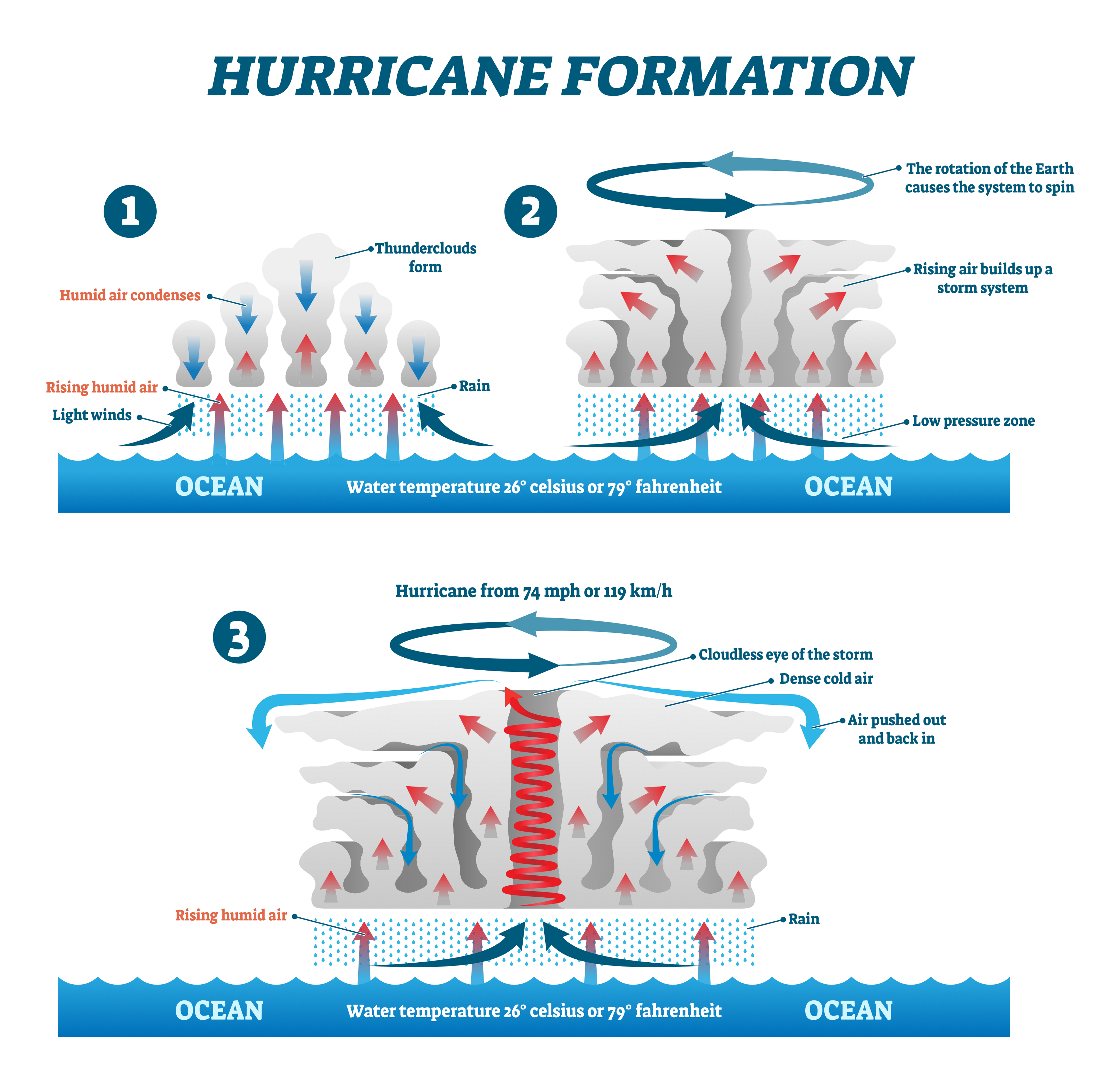
Tropical cyclone formation
Warm, moist air rapidly rises forming area of low pressure
Air from high pressure areas rushes in to take place of rising air
Air rises forming continuous flow of rising air
As air rises, it cools + condenses, releasing heat energy to help power cyclone
Air at top of storm goes outwards away from centre of storm
Coriolis force causes rising air to spiral around centre
Some air sinks in middle, forming cloudless, calm eye
Cyclone moves westwards from source
When cyclone makes landfall, no longer has supply of warm, moist air so loses speed + temp
Tropical cyclone case study
Typhoon Haiyan, Philippines, 2013
Short-term impacts:
7000 killed, 1.9m homeless, 6m displaced
Disease outbreaks due to lack of sanitation, food, water, shelter, medication
Long-term impacts:
Estimated economic impact = $5.8bn
City of Tacloban’s airport severely damaged, affecting business + tourism
Earthquake characteristics
Sudden, violent shaking of ground
Focus (underground) - origin of seismic waves
Epicentre (surface) - point directly above focus
Secondary hazards:
Liquefaction: wet soil is shaken; water from soil rises + turns soil into liquid mud, can cause buildings to fall
Landslides
Fires
Tsunamis
Earthquake distribution
Shores of Pacific Ocean
Many in Atlantic, Indian + Pacific Oceans
Along plate boundaries/hotspots
Earthquake measurement
Magnitude:
Richter (logarithmic)
Moment Magnitude - measures amount of energy released (for every 1.0 amount of energy increases by 30x + amplitude increases by 10x)
Intensity:
Mercalli - measures amount of damage caused
Earthquake causes
Mostly at plate boundaries
Occur at all plate boundaries: convergent, destructive, collision, conservative
Weaker at constructive boundaries as plates moving apart
Stronger at destructive, conservative + collision boundaries
Earthquake impacts case study (developed)
Tohoku, Japan, 2011
Short-term:
Land subsidence in coastal areas as EQ dropped beachfronts by 50cm+
9m wave flooded plants, generators + electrical wiring - people lost energy immediately
4.4m households in N East Japan left without electricity
Long-term:
Economic cost = $235bn (most expensive disaster in history)
Damaged caused by EQ resulted in meltdown of 7 reactors. Radiation levels 8x the normal.
Japan’s transport network suffered huge disruption. Sections of Tohoku Expressway damaged.
Earthquake management case study (developed)
Tohoku, Japan, 2011
Preparation:
EQ + tsunami training drills for mag. 6 triggered tsunamis
Cross bracing in skyscrapers + flexible pistons to absorb shock → buildings sway, not crumble
Short-term relief:
200,000 ppl evacuated from near Fukushima power plant
20km exclusion zone around Fukushima
Long-term response:
Projects to improve roads, railways + airports
Start to invest in renewable energy due to risk of nuclear plants
Earthquake management case study (developing)
Haiti, 2010
Preparation:
Very little - only 1 malfunctional seismometer
Short-term relief:
Many countries sent people to help (medical search + rescue, food + water)
Many US troops flew over to distribute aid
Mass graves filled with bodies to get them off streets + prevent spread of disease
Long-term response:
World Bank cancelled half of Haiti’s debt + gave 5yr payment holiday on remaining half
More health workers trained + given incentives to stay in Haiti
New settlements built away from high-risk locations
General earthquake preparation methods
Early warning systems: if EQ detected, warn people before ground shakes
Building design: retrofitting, cross-bracing
Geographic Info Systems (GIS): mapped info about prev. EQs - vulnerable areas, transport access etc. to prepare more effectively
Remote sensing: satellite images used for EQ info e.g. damage caused, access problems, helping prepare for future EQs in that location
Education + EQ drills: practice ‘drop, cover, hold on’, keep important supplies in EQ kit, fix heavy furniture to wall
General short-term relief methods
Evacuation
Temporary shelters
Exclusion zones
Provide food, water, medical care
General long-term response methods
Hazard mapping
Risk assessment
Improve infrastructure
Change building regulations to combat EQs
Volcano characteristics
Magma chamber
Lava flow - stream of molten rock
Pyroclastic flow - mixture of rock, gas, ash that travels rapidly (high temp + mobility)
Lahar - mudflow created when rainwater + volcanic ash mix
Volcano distribution
Mostly on plate boundaries
‘Pacific Ring of Fire’ - concentration of volcanoes along destructive margins around Pacific
Volcano measurement
Volcanic Explosivity Index (VEI): 1-8 based on amount of material ejected, height of cloud + damage caused
Volcano causes
Occur at constructive, destructive + hotspots
Not at conservative or collision
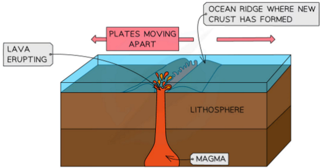
How volcanoes form at constructive boundaries
Plates moving away from each other
Constructive boundaries often under sea
Lava escapes through gap left when plates move away
Lava cools + hardens forming new crust
Lava is runny + eruptions less explosive
Forms shield volcanoes with gently sloping sides
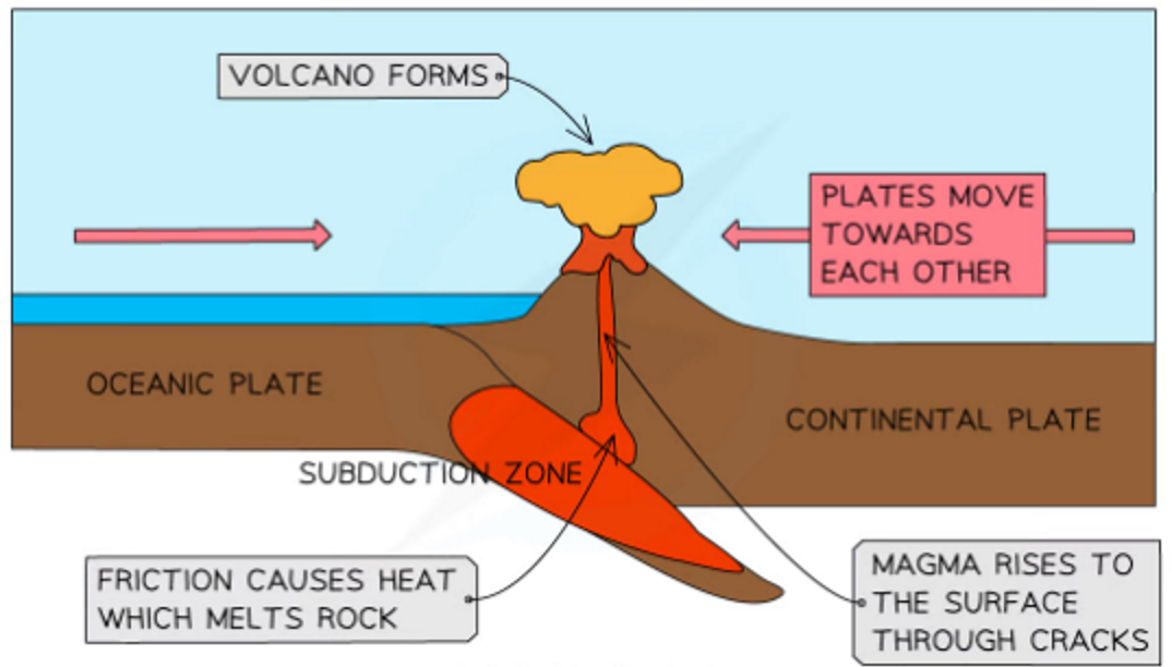
How volcanoes form at destructive boundaries
Plates move towards each other
Heavier, denser oceanic plate subducts under lighter continental plate
In subduction zone, plates come together causing friction
Friction causes heat + plate material melts forming magma
Magma rises to surface through cracks in crust
Cooling lava + ash builds up, forming volcano
Lava is sticky + explosive eruptions
Forms composite/stratovolcanoes
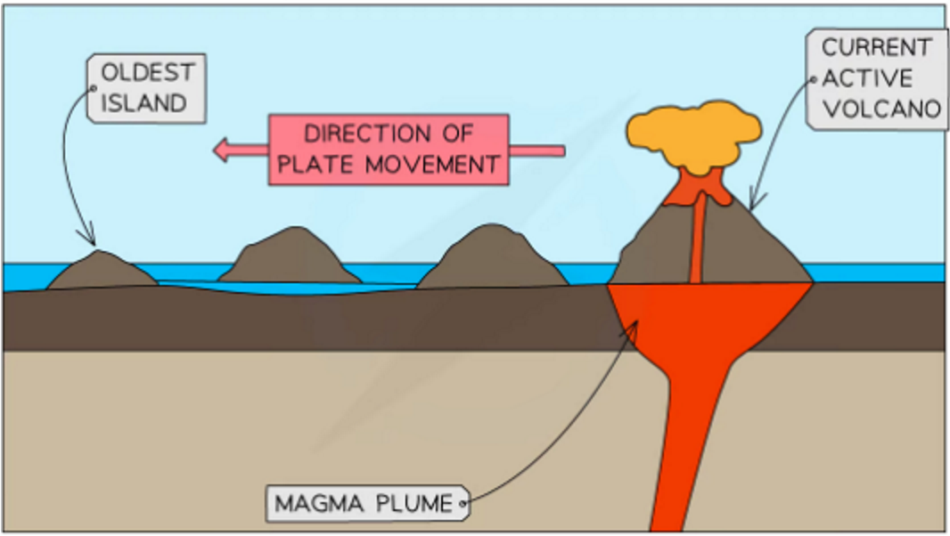
How volcanoes form at hotspots
Tectonic plate passes over magma plume
Magma rises to surface through cracks in crust
Volcano case study
Montserrat, 1995-2013
Short term impacts:
1997 - pyroclastic flow killed 19 people
Largest settlement, Plymouth (4000 pop.) was covered in ash and abandoned
75% of island covered in ash
Long term impacts:
High level of unemployment (>50%)
Population decreased by 90%
Housing shortages leading to 70% increase in rent
Constructive plate boundary
Two oceanic plates ← →
Magma rises to fill gap + turns into solid rock as it cools
New crust forms mid-ocean ridge
Both volcanoes + EQs here (caused by movement of magma through crust)
e.g. Mid-Atlantic Ridge
Destructive plate boundary
Oceanic + continental plate → ← due to convection currents in mantle
Denser, heavier oceanic plate subducts under lighter continental plate
Both volcanoes + EQs here (caused by friction of plates, when one slips past other, releases seismic energy)
e.g. Nazca + S American plates
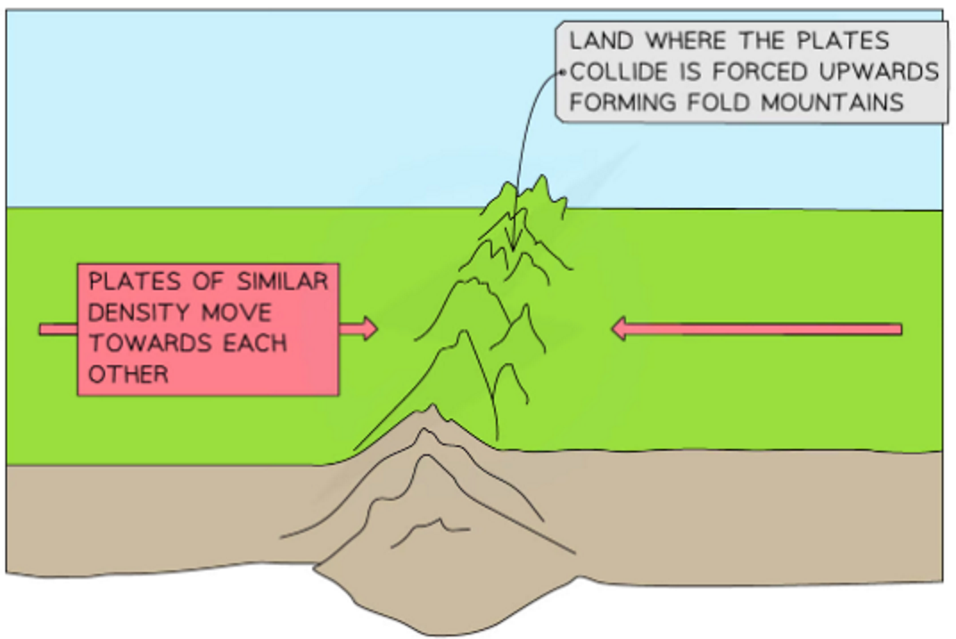
Collision plate boundary
Two continental plates → ←
Neither is dense enough to subduct so land pushed upwards
Forms fold mountains
Mainly EQs here
e.g. Himalayas
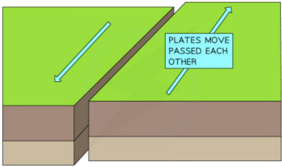
Conservative plate boundary
Two continental plates ⇆
Plates move past at diff speeds in opposite directions
Friction causes EQs
e.g. San Andreas Fault
Why people live in areas at risk from volcanoes
Minerals - valuable mineral resources such as diamonds, gold, copper emerge during eruptions
Fertile soil - volcanic ash contains mineral that enrich soil
Geothermal energy - water running through earth’s crust is heated by volcanic rock at plate margin. Hot water emerges as hot springs: can be used to heat homes, factories, business premises.
Tourism - volcanoes interest many people + attract tourists
e.g. Mount Vesuvius: hundreds of thousands of visitors each year
Reasons people live in areas at risk from natural hazards
Lack of education + info - people unaware of real risks, particularly in poor, undeveloped areas
People aware of risks but live there anyway - area may offer attractive benefits
People unable to move away from hazardous areas due to lack of money, being worried they won’t find a job elsewhere or they’re settled/have family
Cities in high-risk areas represent centuries of investment (human money + effort) - no society is rich enough to throw away all this investment and abandon those cities
Physical factors affecting vulnerability to natural hazards
Global location - some areas experience more hazards because they’re near plate boundaries/in tropical regions
Physical environment - steep slopes can increase chances of landslides; coastal areas more vulnerable to storm surges + tsunami
Social factors affecting vulnerability to natural hazards
Pop. density - more people in area = higher number of deaths + injuries. High pop. density also means buildings are likely to be more densely packed.
Education - people with higher level of education likely to be wealthier + able to afford better-quality housing. Education level also affects how informed people are about risks.
Economic factors affecting vulnerability to natural hazards
Wealth + level of development - quality of buildings, healthcare, infrastructure depend on wealth of country
Insurance - people in poverty can’t afford insurance + insurance companies only insure well-built homes/structures
Buildings - planning control, poverty, building styles, quality of materials affect safety of buildings
Technology - wealthier countries have more access to monitoring equipment so may get better warning of events