Geology Finals
1/84
There's no tags or description
Looks like no tags are added yet.
Name | Mastery | Learn | Test | Matching | Spaced |
|---|
No study sessions yet.
85 Terms
Explain how luster can be used to identify minerals
Luster describes how a mineral reflects light. It can be used to identify minerals by distinguishing between metallic (shiny like metal) and non-metallic (e.g., glassy, dull, pearly) appearances, which helps narrow down possibilities.
Explain how Hardness can be used to identify minerals
Hardness is tested by what the mineral can scratch or what can scratch it, using Mohs Scale. This quickly narrows down the mineral's identity.
Explain how Steak can be used to identify minerals
Streak is the color of a mineral's powder. By rubbing the mineral on a streak plate, you reveal its true color, which is more reliable for identification than its surface appearance.
Which of the following materials are mineraloids? The definition of mineral can be used to explain your choice.
i) Amber
ii) Calcite
iii) Coral
iv) Halite
iii) Agate
Amber, Agate
Which of the following material aren't a mineral? Definition of mineral can be used to explain your choice.
i) Water
ii) Calcite
iii) Glass
iv) Halite
iii) Gypsum
Water, Glass
Sha Tin Granite is found in shoreline of star fish bay. Give two minerals names that can be found in the granite. How do you identify granite in a site visit?
Quartz and Feldspar
You can recognize granite by its speckled look with different colored grains all stuck together. Look specifically for the hard, glassy grains of quartz and the lighter-colored feldspar crystals mixed in. The rock will feel rough and hard.
Describe with sketch the biological weathering. Which weathering grade of the rock can be broken by finger pressure? How can the six decomposition terms be used to classify weathering grades of rock?
Sketch root growing around a rock
Weathering grade that can be broken by finger pressure is GRADE V
The six decomposition terms (Grades I to VI) define a standardized scale for assessing the degree of weathering of a rock mass, primarily based on the material's strength and condition.
Explanation:
Grade I (Unweathered): Rock shows no sign of weathering.
Grade II (Slightly weathered): Discoloration on major discontinuity surfaces.
Grade III (Moderately weathered): Less than half of the rock material is disintegrated or decomposed.
Grade IV (Highly weathered): More than half of the rock material is disintegrated or decomposed.
Grade V (Completely weathered): All rock material is disintegrated into soil but the original mass structure is largely intact. The material can be broken by hand pressure.
Grade VI (Residual soil): All rock material is converted to soil, and the original mass structure and material fabric are destroyed.
Draw a labelled diagram to show the texture of clastic sedimentary rock including roundness and sorting.

Explain what is Tolo Harbour Formation
Tolo Harbour Formation:
A Permian-age rock formation found near Tolo Harbour, composed of a lower layer of mudstone and silty limestone, and an upper layer of mudstone, siltstone, sandstone, and conglomerate.
Explain what is Pat Sin Leng Formation
Pat Sin Leng Formation:
An Early Cretaceous-age rock formation characterized by a sequence of conglomerates, sandstones, and siltstones that are often reddish or purple in color, containing subrounded volcanic rock fragments.
Describe the features of following surface processes: Meandering River, Beach and Backshore.
Meandering River:
A winding river that erodes its outer bank and deposits sediment on its inner bank, creating a floodplain.
Beach:
The sloping zone of sand or gravel between low and high tide, actively shaped by wave swash and backwash.
Backshore:
The upper part of a beach, landward of the high-tide line, which is usually dry and only affected by waves during severe storms or exceptionally high tides.
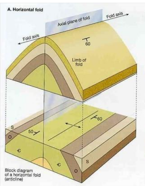
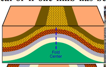
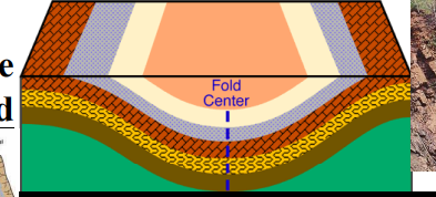
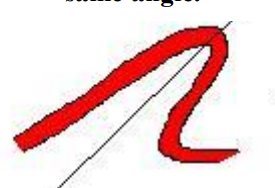
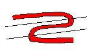
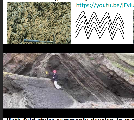
Draw diagram to compare the horizontal fold and plunging fold. How do they form? What is the implication of them?
Horizontal Fold: Forms when the compressive force is directed horizontally, and the resulting folds have a horizontal hinge line.
Implication: Create long, parallel ridges and valleys (anticlines and synclines). They are crucial for understanding the regional stress field and broad structural geometry of an area.
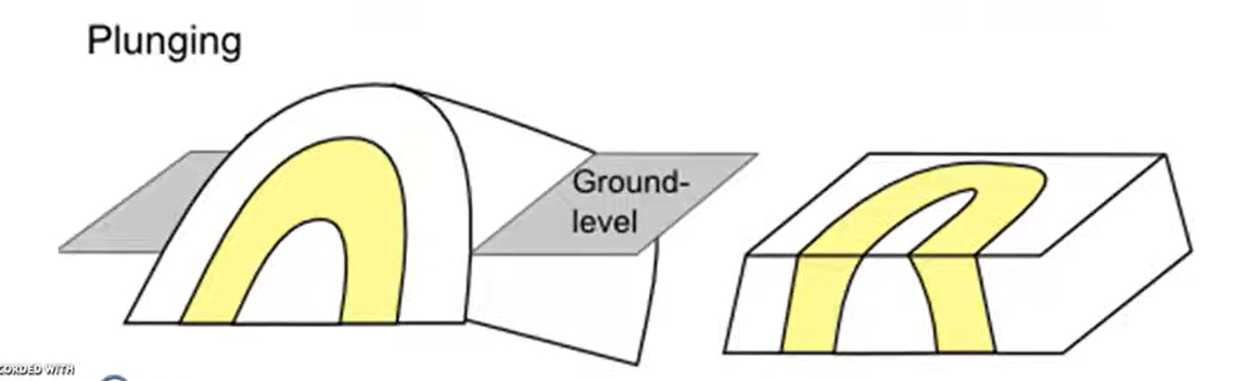
Plunging Fold:
A plunging fold is a fold whose axis (or hinge line) is inclined from the horizontal. The angle of this inclination is known as the plunge.
Implication: Create distinctive, curved or "V"-shaped outcrop patterns on geological maps
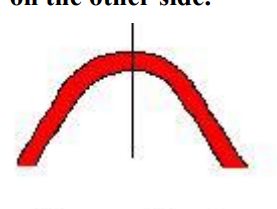
Anticline
An anticline is a convex up fold in rock that resembles an arch like structure with the limbs dipping away from the center of the structure.
syncline
A syncline is a fold where the rock layers are warped downward.
Symetrical Fold
Asymmetrical Fold
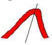
Overturned fold
Recumbent Fold
Isocline fold
The limb of the folded layers are parallel though the strata may vary in thick and the axial plane are parallel
Recumbent fold
A fold in which the axial plane is more or less horizontal. Bent back on itself.
Chevron fold
Angular fold - called a "chevron" where the hinge is very abrupt, the limbs are straight and symmetric.
Kink fold
A fold with planar limbs, sharp angular hinge and asymmetric.
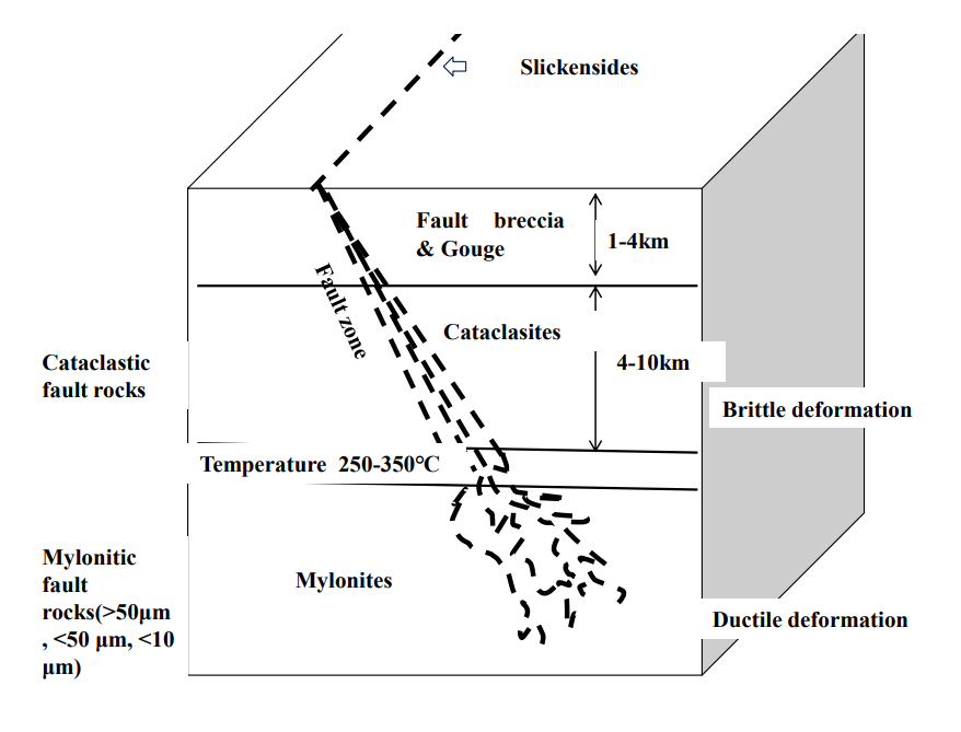
Give six pieces of evidence would you seek to prove the existence of fault. Draw diagram to show relationship of evidences within the fault zone.
1) Fault Slickenside - Polished, scratched surfaces on the fault plane showing movement direction.
2) Cataclasitic rocks(fault rocks) - cataclastic rocks present in the fault zone. Individual fragments are generally sharp, angular shape characteristic of brittle fracturing.
3)Fault breccia - The assembly of broken fragment frequently found along fault.
4) Gouge - produced by friction between the two sides when a fault moves.
5) Pseudotachylite- a dark, glassy, or very fine-grained rock that forms by frictional melting during rapid fault movement, typically in an earthquake.
6) Mylonitic rocks - are fine-grained, foliated metamorphic rocks formed by ductile deformation under high stress and strain within a shear zone, deep in the crust.
Hinge
Hinge - the point of maximum curvature.
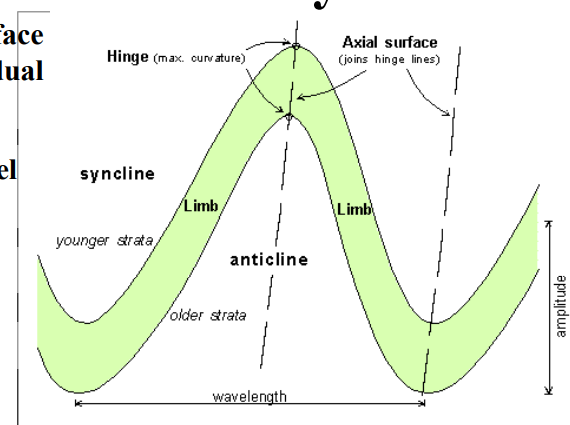
Limb
sides of the fold.

Axial plane or surface
the surface connecting all of the hinges of individual formations within one fold.

Axis
the line that when moved parallel to itself generates the fold.

Crest
the highest point on a fold.

Trough
the lowest point on a fold.

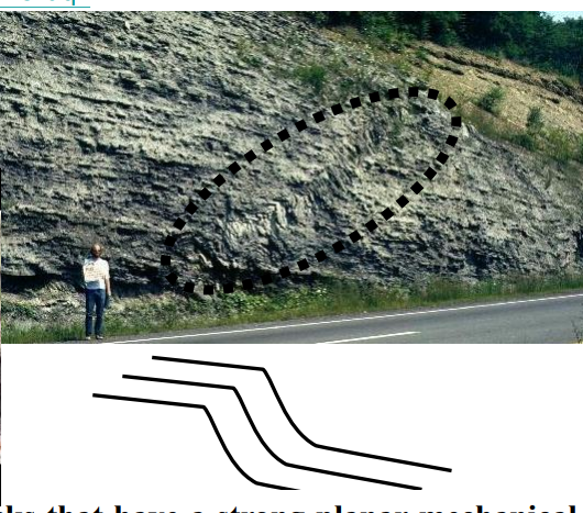
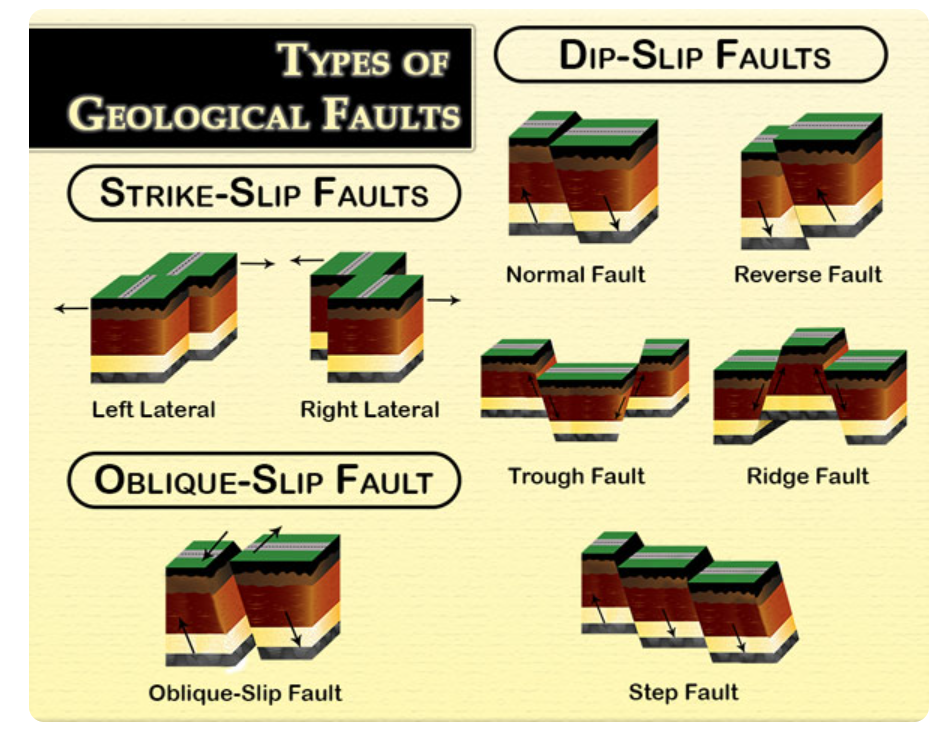
Sketch the types of faults. Describe the definition and formation of them.
Normal Fault:
Caused by tension (pulling apart). The hanging wall moves down relative to the footwall.
Strike-slip:
fault accommodate horizontal slip between adjacent blocks. (Left lateral or right lateral)
Reverse Fault:
Caused by compression (squeezing). The hanging wall moves up relative to the footwall.
Oblique-slip fault:
combination of strike-slip and dip-slip (normal or reverse) motion.
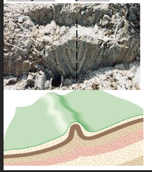
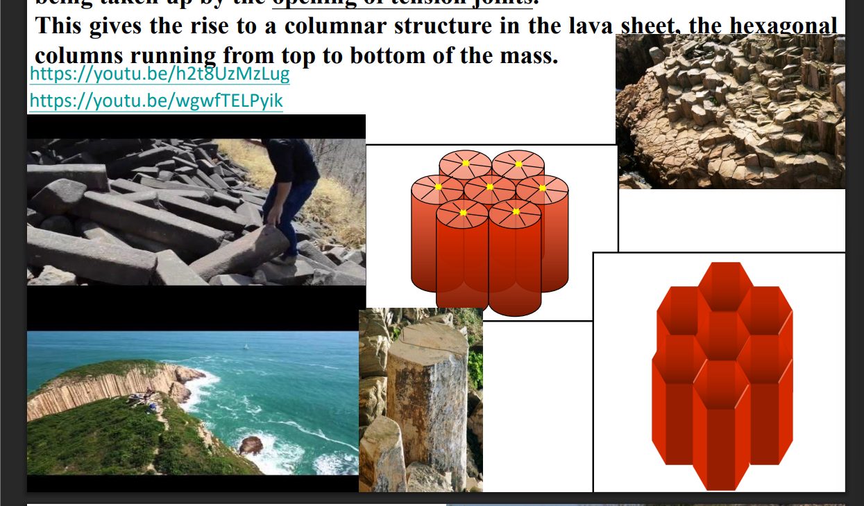
Sketch the rock joints in extrusive igneous rock. Discuss the formation of the joints.
In extrusive igneous rocks like basalt, joints form as the hot lava cools and contracts. The contraction creates tensile stresses, causing the rock to fracture into vertical hexagonal columns. These are called columnar joints, and they form perpendicular to the cooling surface.
Joint
is a surface fracture or parting in a rock, without displacement
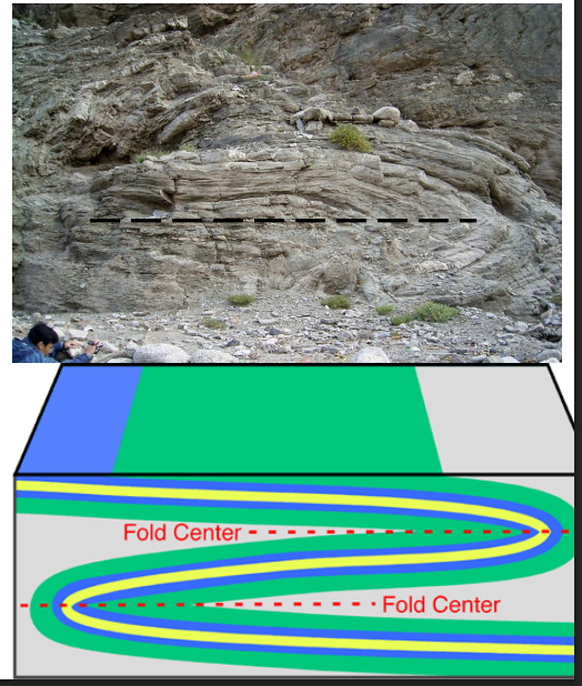
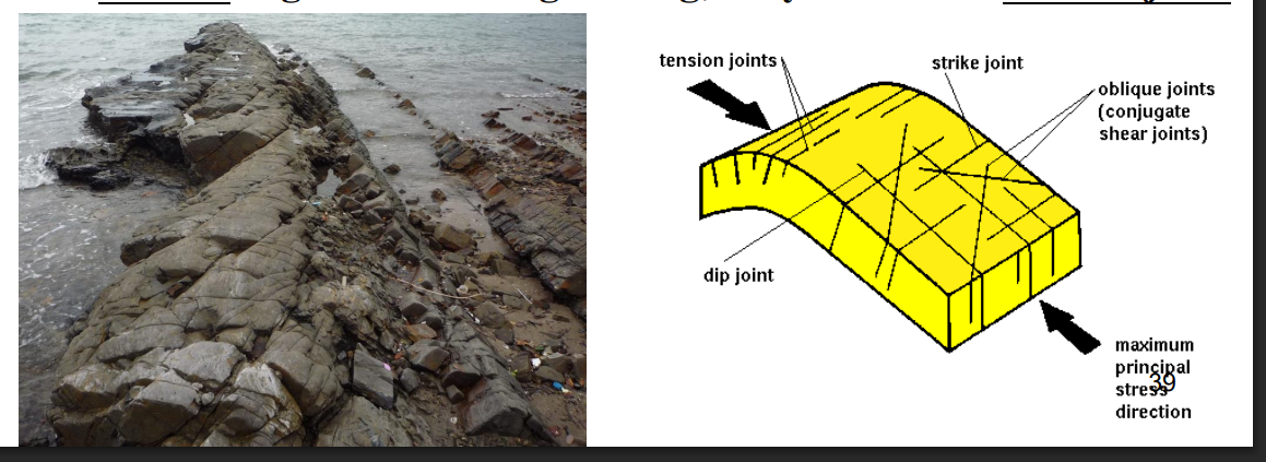
Joints in folded sedimentary rocks
In sedimentary rocks, joints usually form due to stress release, burial and uplift, or folding.
Common types include:
Strike joints – parallel to the rock layers’ strike.
Dip joints – parallel to the dip direction.
Tension joints – form at fold crests where stretching occurs.
These joints are typically perpendicular or oblique to bedding planes and form without displacement.
How to use the stereographic projection method to solve the geometric problem in structural geology.
The stereographic projection method in structural geology is used to show and analyze the orientation of planes and lines on a stereonet.
To use it:
Mark the strike of the plane on the outer circle.
Rotate the overlay so the strike aligns with the north–south line.
Plot the dip angle along the east–west line and draw the great circle.
Mark the pole (90° from the great circle) and rotate back to original position.
This method helps determine apparent dip, trend and plunge of lines, and angles between planes accurately.
Name two types of samplers commonly used to obtain relatively undisturbed soil samples from a borehole during geotechnical investigation.
Shelby tube sampler (thin‑walled tube sampler)
Piston sampler
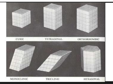
Give the name and sketch six crystal systems.
Cubic
Tetragonal
Hexagonal and Trigonal
Orthorhombic
Monoclinic
Triclinic
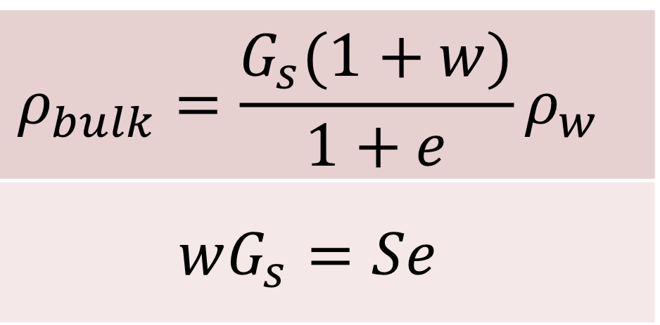
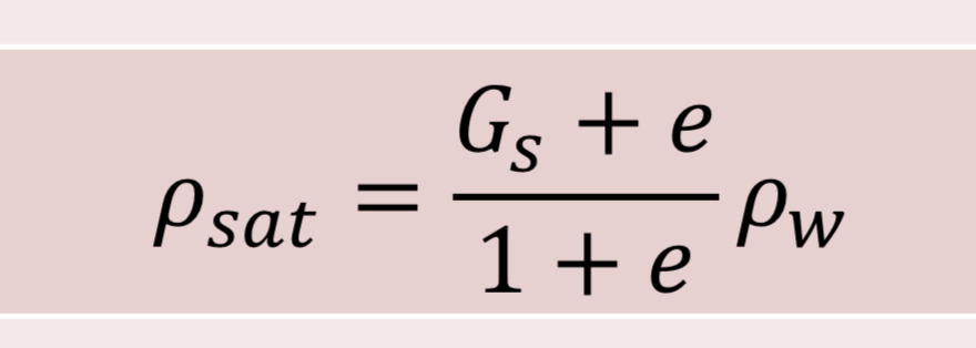
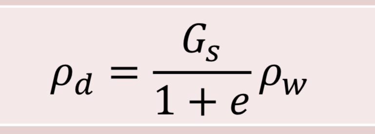
Bulk density
Pbulk=Total mass/total volume
Dry density
Pd=Mass of solid/total volume
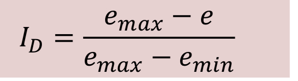
Void ratio
E=Volume of air and water/volume of solid
Porosity
N=Volume of air and water(Vv)/total volume
Water content
W=Mass of water/mass of solid
Specific gravity of soil particles
Gs=(Mass of solid/volume of sold)/(mass of water/volume of water)
Degree of saturation
S=Volume of water/volume of water and air(Vv)
Air content
A=Volume of air/total volume
Bulk density
Saturated density
Dry density
Unit weight(dry, saturated,bulk). “Just change p”

Submerged(buoyant) unit weight
Relative density
Explain what is Ma On Shan formation
Ma On Shan Formation
Age: Carboniferous (San Tin Group)
Rock: Marble
Key: 200m thick, dolomitic marble, found in boreholes
Lion Rock Suite
Age: Jurassic-Cretaceous
Rock: Granite/Quartz Monzonite
Key: 4th plutonic pulse (e.g., Kowloon Granite)
Describe the Lian Hua shan fault zone
a major northeast-trending deep fault zone in southeastern China.
It is a complex deformational and metamorphic belt featuring ductile shear zones, crushed rock, and dynamic metamorphism.
Hong Kong is located at the southwestern end of this zone, bounded by the Shenzhen and Haifeng faults.
What is Bluff head formation
Age: Devonian
Rock: Sandstone, siltstone, conglomerate
Key: Oldest rock in HK, Placoderm fossils proved Devonian age
Carboniferous rock
Carboniferous rock are present throughout the northwestern parts of Hong Kong.
all belong to the San Tin Group. This is divided into three formation: the oldest being the Yuen Long Formation and Ma On Shan Formation and Young being the Lok Ma Chau Formation.
Pat Sin Leng Formation
Age: Early Cretaceous
Rock: Conglomerate, sandstone
Key: Fluvial deposits, reddish-brown, tuffaceous
Yuen Long Formation
Age: Carboniferous (San Tin Group)
Rock: Marble
Key: 600m thick, found in boreholes, Long Ping (dark) & Ma Tin (white) members
Lok Ma Chau Formation
Age: Carboniferous (San Tin Group)
Rock: Metamorphosed siltstone/sandstone
Key: 700m thick, Mai Po (fine) & Tai Shek Mo (coarse) members
Tolo Harbour Formation
Age: Permian
Rock: Mudstone, siltstone, sandstone
Key: Fossiliferous (ammonites), exposed at Ma Shi Chau
Lamma Suite
Age: Jurassic-Cretaceous
Rock: Granite/Granodiorite
Key: 1st plutonic pulse (e.g., Tai Po Granodiorite)
Kwai Chung Suite
Age: Jurassic-Cretaceous
Rock: Granite
Key: 2nd plutonic pulse (e.g., Needle Hill, Sha Tin Granite)
Cheung Chau Suite
Age: Jurassic-Cretaceous
Rock: Granite/Rhyodacite
Key: 3rd plutonic pulse
Port Island Formation
Age: Late Cretaceous
Rock: Conglomerate, sandstone
Key: Terrestrial deposits, reddish-brown
Ping Chau Formation
Age: Tertiary
Rock: Silestone
Key: Youngest bedrock, thinly-bedded, on Ping Chau Island
note on the geological history of Hong Kong (DCJCQ)
Devonian: Deposition of Bluff Head Formation in a shallow sea (oldest rock).
Carboniferous - Early Jurassic: Marine sedimentation forming the San Tin Group marbles and Tolo Harbour Formation.
Middle Jurassic - Early Cretaceous: Period of intense volcanism (4 volcanic groups) and granite intrusion (4 granite suites).
Late Cretaceous - Tertiary: Post-volcanic sedimentation, forming Pat Sin Leng (fluvial) and Ping Chau (marine) formations.
Quaternary: Erosion forms modern landscape and superficial deposits.
Braided River
What it is: A wide, shallow river channel split into multiple, intertwining smaller channels.
Key Features:
Numerous sediment bars (eyots) are exposed.
High sediment load, highly variable water discharge.
Process: Occurs when a river carries more sediment than it can transport.
Foreshore
What it is: The part of a beach that is regularly covered and exposed by the tides.
Key Features:
Zone from the level of lowest tide to the average high-tide level.
The most active zone for wave action.
Location: The wet, sloping part of the beach you walk on at the water's edge
Lagoon
What it is: A shallow body of quiet seawater separated from the open ocean.
Key Features:
Formed behind a bay bar, barrier island, or sand spit.
calm, low-energy environment.
Process: Created when a bar completely cuts off a bay from the sea.
Tombolo
What it is: A ridge of beach material (sand or shingle) that connects an island to the mainland or another island.
Key Features:
A type of wave-deposited landform.
Created by longshore drift and wave action.
Example: Luk Keng in Hong Kong.
Weathering Types:
Physical: Block & Granular Disintegration, Freeze-thaw, Salt Crystallization, Insolation/Exfoliation
Chemical: Solution, Hydration, Oxidation, Carbonation, Hydrolysis
Biological: Root action, Lichen, Boring/Grazing organisms
5 Glacial Landforms
Cirque
Arête
Horn
Moraine
Drumlin
Cleavage
The tendency to break along flat, parallel planes of weakness.
Fracture
Breaks with irregular surfaces
Specific Gravity
Density relative to water.
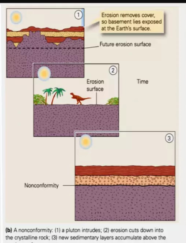
Nonconformity
Formation:
Igneous or Metamorphic rock forms deep underground.
It is uplifted and the overlying rock is eroded away, exposing the igneous/metamorphic basement at the surface.
The area subsides, and new sedimentary layers are deposited directly on top of this eroded basement.
Implication: Represents a very long gap in the geologic record, involving the deep burial/crystallization of rock, followed by uplift, extensive erosion, and finally a return to sedimentation.
What are the 5 defining characteristics of a mineral?
1) Naturally occurring, 2) Inorganic, 3) Solid, 4) Definable chemical composition, 5) Ordered internal crystal structure.
What is the difference between magma and lava?
Magma is molten rock below the Earth's surface. Lava is molten rock on the Earth's surface.
Compare the formation of tor, corestone, ventifact, and erratics. What type of landscape could you find them?
Tor: Formed by chemical weathering (spheroidal weathering) of jointed rock (e.g., granite) and subsequent erosion. Found in upland granitic landscapes.
Corestone: A rounded, unweathered boulder formed by in-situ chemical weathering; it is the component that makes up a tor. Found within weathered rock profiles.
Ventifact: A rock faceted and polished by wind-blown sand abrasion. Found in arid deserts or polar regions.
Erratic: A boulder transported and deposited by a glacier, differing from the local bedrock. Found in glacial landscapes.
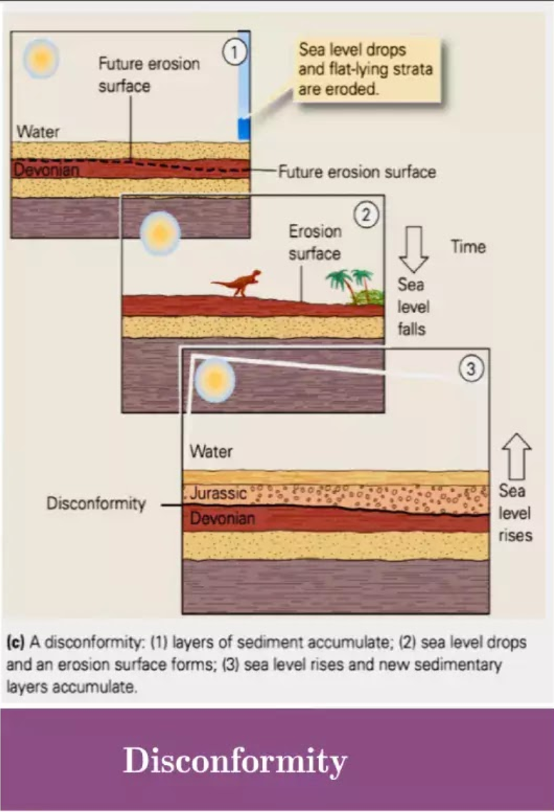
Disconformity
Formation:
Sedimentary layers are deposited.
Sea level drops, exposing the layers to erosion, creating a flat, irregular surface.
Sea level rises again, and new sedimentary layers are deposited on top of the old, eroded surface.
Implication: Represents a gap in the geologic record where a period of erosion occurred between periods of deposition, with no tectonic deformation.
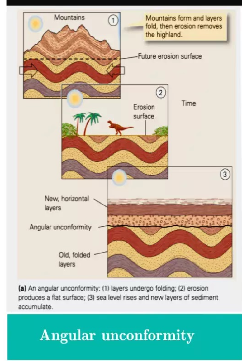
Angular Unconformity
Formation:
Sedimentary layers are deposited horizontally.
Tectonic forces (compression) tilt or fold these layers.
The area is uplifted and the tilted layers are eroded down to a flat plane.
The area subsides, and new, horizontal sedimentary layers are deposited on top of the eroded surface.
Implication: Represents a major mountain-building event (orogeny). It implies a sequence of deep deposition, tectonic deformation, prolonged erosion, and a return to subsidence and deposition. It shows the most dramatic change in the geological record.
Name three types of soil parameters that should be determined using undisturbed soil samples.
(a) Consolidation behaviour and parameters
(c) Shear strength
(d) Stiffness parameters
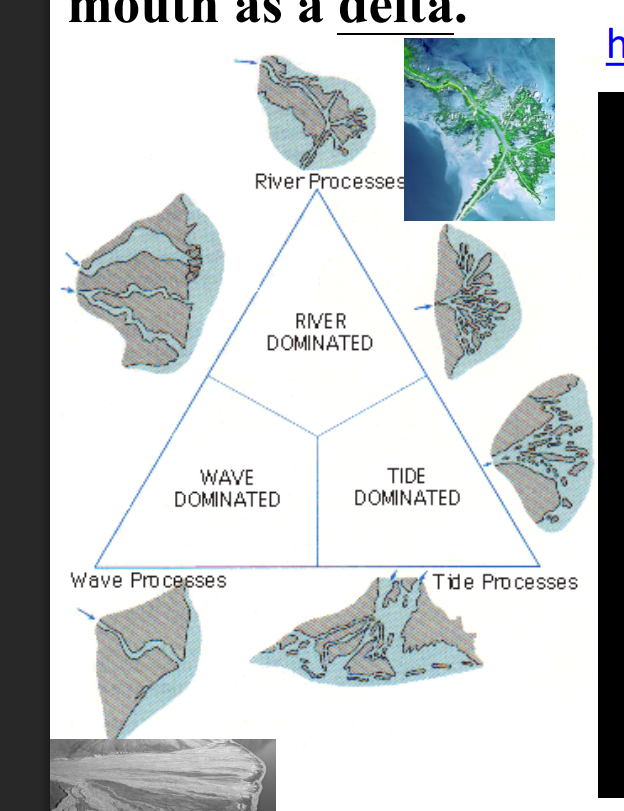
What factor reshaped the deltas? Draw a diagram to show the types of deltas.
River Discharge & Sediment Load: The volume and type of sediment (sand, silt, clay) the river carries.
Wave Energy: Waves can rework and redistribute sediment along the shoreline, creating beaches and barrier islands.
Tidal Range & Currents: Strong tides can scour sediment and create a network of tidal channels, preventing a classic delta shape from forming.
Basin Topography & Geology: The shape and depth of the coastline and the stability of the underlying sediment.
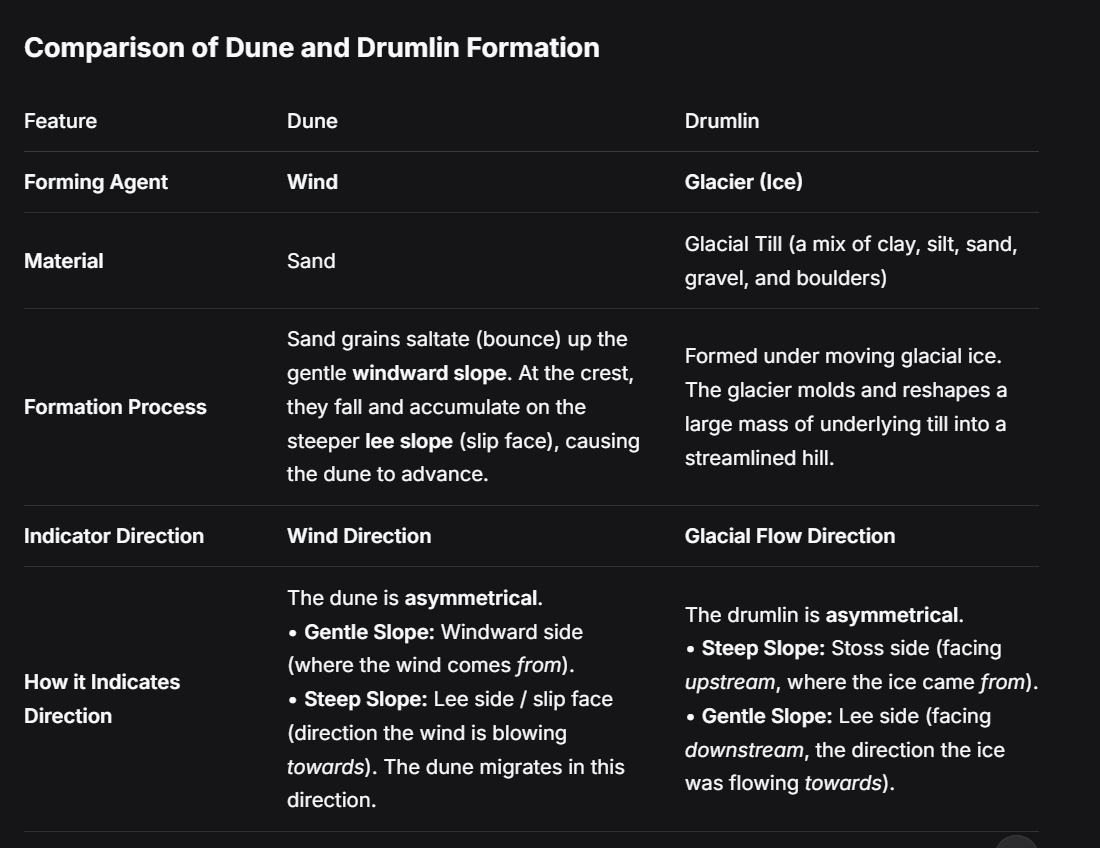
Compare the formation of dune and drumlin. How are they indicating the direction of wind and glaciers?