Hazardous Earth
1/51
There's no tags or description
Looks like no tags are added yet.
Name | Mastery | Learn | Test | Matching | Spaced | Call with Kai |
|---|
No analytics yet
Send a link to your students to track their progress
52 Terms
Structure of the earth’s crust
Thickness:
Continental - ~35km
Oceanic - 5-10km
Density:
Continental: 2.6kg/m^3
Oceanic: 3kg/m³
Mineral composition:
Continental: granitic, silicon, aluminium
Oceanic: basaltic, silicon and magnesium
Structure of the Earth’s upper mantle
Top layer - Lithosphere
Rigid layer
At least 80km in thickness most places
Bottom layer - Asthenosphere
Semi-molten/viscous.
Extends from 100km down to 300km
Believed that convection currents exist within the asthenosphere from the intense heat in the low mantle.
So, the semi-molten asthenosphere flows, carrying the solid lithosphere and crust with it
Define earthquake
Earthquakes are sudden and brief periods of time of intense ground shaking as a result of the release of pressure that has accumulated over time.
Define volcanic eruption
A Volcanic eruption is the release of magma, gases and ash from a volcano into the earths crust or onto the surface resulting from tectonic movement and a build up of pressure within the Earth’s crust.�
What is plate tectonic theory?
The theory that the Earth’s outer layer (lithosphere) is divided into large, slow-moving plates that float on the asthenosphere.
The movement and interaction of these tectonic plates at their boundaries explain geological phenomena like earthquakes, volcanic eruptions, formation of mountains and the movement of continents.
What is some geological evidence for continental drift theory?
The fit of continents such as South America and Africa on either side of the Atlantic
Evidence from 290 million years ago of the effects of contemporaneous glaciation in southern Africa, Australia, South America, India and Antarctica - suggesting that these land masses were joined close to the South pole
What is some biological evidence for continental drift theory?
Similar fossil brachiopods (marine shellfish) found in Australian and Indian limestones
Similar fossil animals found in South America and Australia, especially marsuials
Paleomagnetism
The Earth’s polarity changes orientation every 400,000 - 500,000 years. As igneous rocks cool, the iron minerals within them line up in such a way to indicate where the north pole was at the time of their formation.
A pattern of magentism was found in the basaltic rocks of the ocean floor, showing mirror images of repeating stripes moving away from the Mid-Atlantic ridge.
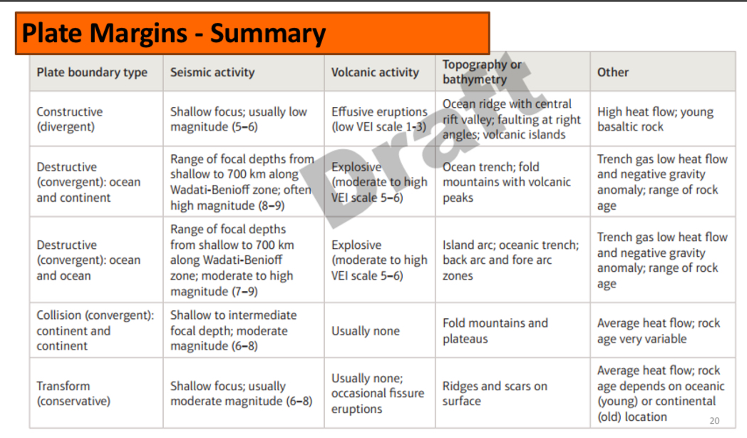
What plates do collision margins involve?
The convergence of two continental plates
What occurs at a collision margin?
As the two plates are of roughly equal density, there is no subduction
Ocean sediments between the two continental slabs are crumpled upwards, resulting in the formation of major uplift and fold mountain chains
No volcanic activity. Frequent earthquakes, but they are deep and have limited impact
Whats an example of a collision plate boundary?
The Himalayas:
250 million years ago, the Indo-Australian plate and the Eurasian plate were separated by the Tethys Sea.
The Indo-Australian plate moved northwards at a rate of about 5.8cm per year
It therefore collided with the Eurasion plate, leading to an orogeny (mountain building episode) about 50 million years ago
The Himalayas now rise to a height of about 9000m. Rocks found high up in the Himalayas contain fossils of small sea creatures, confirming the existence of the previously intervening ocean
What plates do destructive boundaries involve?
Occur when two plates move together due to converging convection currents in the mantle
Continental meets an Oceanic
or
Oceanic meets an Oceanic
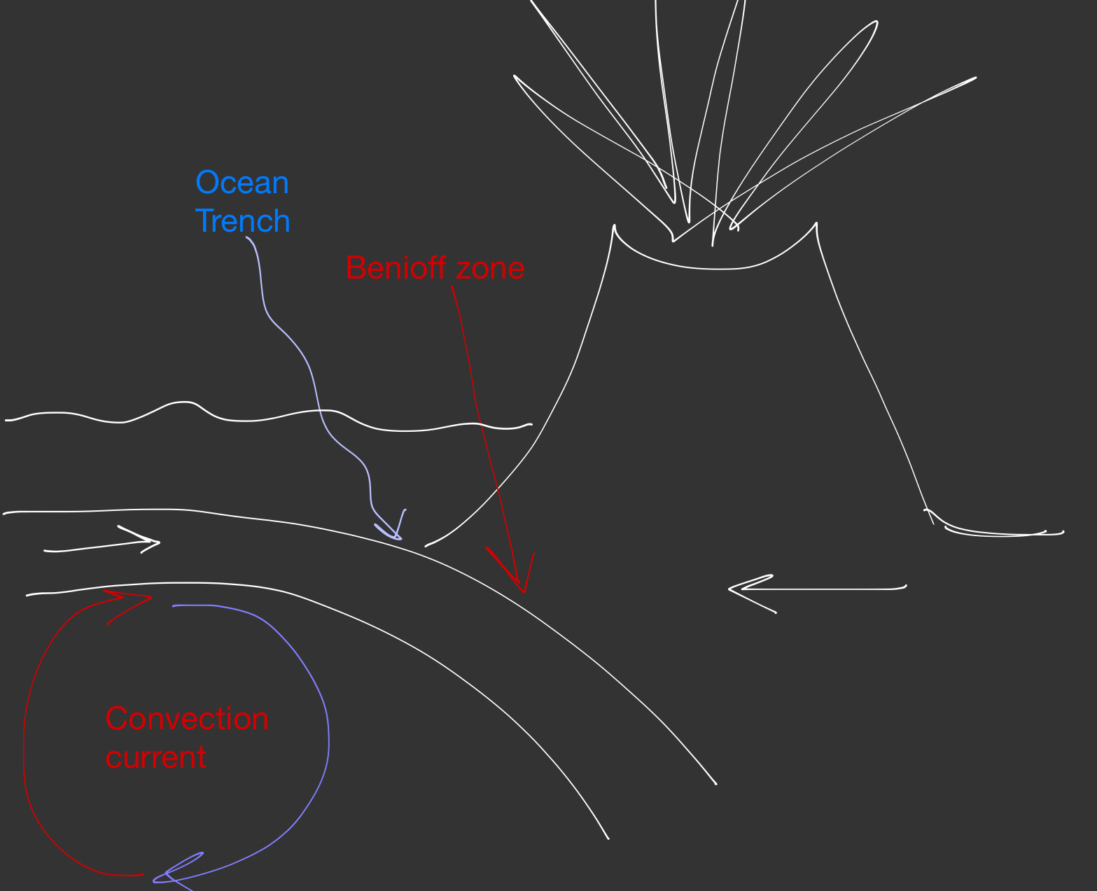
What occurs at a Continental-Oceanic Destructive boundary
On convergence, the oceanic plate will subduct beneath the continental due to its higher density
At the point of subduction, an asymmetrical ocean trench is formed
Friction in the subduction zone → a buildup of pressure. The periodic release of this pressure causes intense seismic activity along the Benioff zone
The continental plate buckles and uplifts into fold mountain chains. The newly formed silica-rich magma from the melting oceanic plate has a low density and rises and squeezes its way up through faults in this overlying rock.
So, some of the fold mountains become strato-volcanoes
Example: South America
What occurs at an Oceanic-Oceanic destructive boundary
Similar to continental-oceanic: One of the oceanic plates is likely to be slightly older and denser than the other, so subduction will still occur, oceanic trenches will still form, and earthquakes will still occur along the Benioff zone
However, there are no fold mountains (bc no continental plate)
Instead, magma that forms as the subducting plate melts rises through the overlying oceanic crust to form a series of volcanic island in a curved linear shape: island arc (e.g. the Mariana islands)
Also, slippage along subduction zone is more likely to cause tsunami due to large volume of overlying water
What plates do constructive margins involve
Involve the divergence of two plates
Two distinctive divergent boundaries: On land or under the sea

Example of a constructive margin on land
The African Rift Valley
Most continental interiors are described as ancient shields. These worn down lands are the oldest around and are rigid and stable
However Africa is not a stable ancient shield - a new constructive plate margin is being formed and africa is being ripped in two, with a new ocean beginning to form in between
Diverging convection currents under the African plate have stretched and thinned the overlying crust. The central portion has dropped to form the Great African Rift Valley
Has horst and graben topography
Extends for 4000km with sides up to 600m high
Example of a constructive margin under the sea:
The Mid Atlantic ridge:
The boundary of the Eurasian plate and North American plate
The two plates have diverged, creating a gap through which magma can rise. This cools to form new oceanic crust and the sea floor spreads at 2-5cm per year
The two separating plates are continental, with a new plate of oceanic crust forming in between
What landforms are being formed at the Mid Atlantic ridge
The magma that rises here stems directly from the mantle, and therefore has a silica content.
So, the lava is non-viscous and flows for a long distance, giving shield volcanoes at individual vents
The islands form a long ocean ridge. The ridge is constantly being stretched by the diverging plates beneath and often has its own rift valley down the centre
Small earthquakes do occur - shallow focus, low magnitude, high frequency
What occurs at a conservative plate boundary?
Two plates move past each other - either between or within plates (caused Haiti 2010.)
Usually shallow focus earthquakes. No volcanic activity
As the plates move alongside each other, either in the same direction at diff speeds or in opposite directions, they lock against each other
Friction causes pressure to build, which is eventually released as an earthquake. These usually occur in sequences, so is marginally easier to predict where they will happen.
The only landform present at these boundaries is the transform fault
Example of a conservative plate boundary:
The San Andreas fault:
Both plates are moving NW, but the Pacific plate moves faster
Pacific plate moving 6cm/year
North American plate moving 1cm/year
The San Andreas fault is 1300km long, 18km deep
Summary
Where do explosive eruptions occur?
Convergent plate boundaries
Explosive: What are the characteristics of the lava
Acid (high silica percentage)
High viscosity
Lower temperature at eruption
Explosive: What’s the style of eruption
Violent bursting of gas bubbles when magma reaches surface
Highly explosive
Vent and top of cone often shattered
Explosive: What materials are erupted
Gas
Dust
Ash
Lava bombs
Tephra
Explosive: Frequency of eruption
Tend to have long periods with no activity
Explosive: Shape of volcano
Steep-sided strato-volcanoes
Where do effusive eruptions occur?
Divergent plate boundaries
Effusive: Characteristics of lava
Basic (low silica %)
Low viscosity
Higher temperature at eruption
Effusive: Style of eruption
Gas bubbles expand freely; limited explosive force
Effusive: materials erupted
Gas, lava flows
Effusive: Frequency of eruption
Tend to be more frequent: an eruption can continue for many months
Effusive: shape of volcano
Gently sloping sides, shield volcanoes
lava plateaux when eruption from multiple fissures
Define calderas
Volcanic craters, usually mroe than 2km in diameter.
They develop when an explosive eruption destroys much of the cone and the underlying magma chamber is largely emptied. Without the support of the underground magma, the sides of the volcano collapse to form a caldera.
What are flood basalts
When basic magma erupts from multiple fissures, vast areas can be covered by free-flowing lava. These events are known as flood basalts
Example: the Deccan Plateau in central India covers more than 500,000km²
No large-scale events have taken place in the last 50 million years.
Define hot spot
A fixed area of intense volcanic activity where magma from a rising mantle plume reaches the Earth’s surface.
Example of a hot spot
As the Pacific plate has slowly moved northwest over the Hawaiian hot spot, vast amounts of basalt have accumulated on the ocean floor to produce the hawaiian islands.
Define super-volcano
A volcano that erupts more than 1000km³ of material in a single eruption event
The Yellowstone super-volcano in Wyoming has a caldera measuring 75km in diameter
Volcanic Explosivity Index
Combines magnitude (amount of erupted material) and intensity (speed at which material erupted) into a single number on a scale from 0 to 8.
Each increase in number represents nearly a ten-fold increase in explosivity
What are some hazards of volcanic eruptions
Lava flows, pyroclastic flows, gas emissions
Lahars and flooding associated w melting ice
Tsunamis associated w explosive eruption
Tsunami created by the eruption of Krakatoa in 1883 are believed to have drowned 36,000 people
Earthquake focus vs epicentre
Focus: The point where a series of seismic shock waves originate
Epicentre: Immediately above this point at the Earth’s surface
What are the three types of seismic waves that can travel both along the surface and through the layers of the Earth
Primary (P) waves - fast-travelling, low-frequency compressional waves that vibrate parallel to the direction of enerygu transfer
Secondary (S) waves - opposite of P
Surface (L) waves - slow, low frequency.
What are the categories of focus depth
Shallow focus: 0-70km
Deep focus: 70-700km
Richter scale
Uses the amplitude of seismic waves to determine earthquake magnitude
Logarithm scale, no upper limit
Modified Mercalli Scale
Measures earthquake intensity and its impact
Relates ground movement to impacts that can be felt and seen by anyone in the affected location
Moment Magnitude Scale (MW)
Measures the energy released by an earthquake more accurately than the Richter scale.
Uses the amount of physical movement caused by an earthquake, which is a direct function of energy
Hazards generated by earthquakes
Ground shaking and ground displacement
Liquefaction
Landslides and avalanches
Tsunamis due to sea bed uplift and underwater landslides
Flooding
Whats the disaster risk equation
Frequency/Magnitude of hazard (H) x Level of vulnerability (V)
———————————————————————-— = Risk
Capacity of population to cope and adapt (C)
Define vulnerability
The ability of a person or community to withstand exposure to, and risks from, a hazard such as an earthquake or volcanic eruption
Define resilience
An indication of the rate of recovery from a hazardous event that has put an individual and/or community under stress
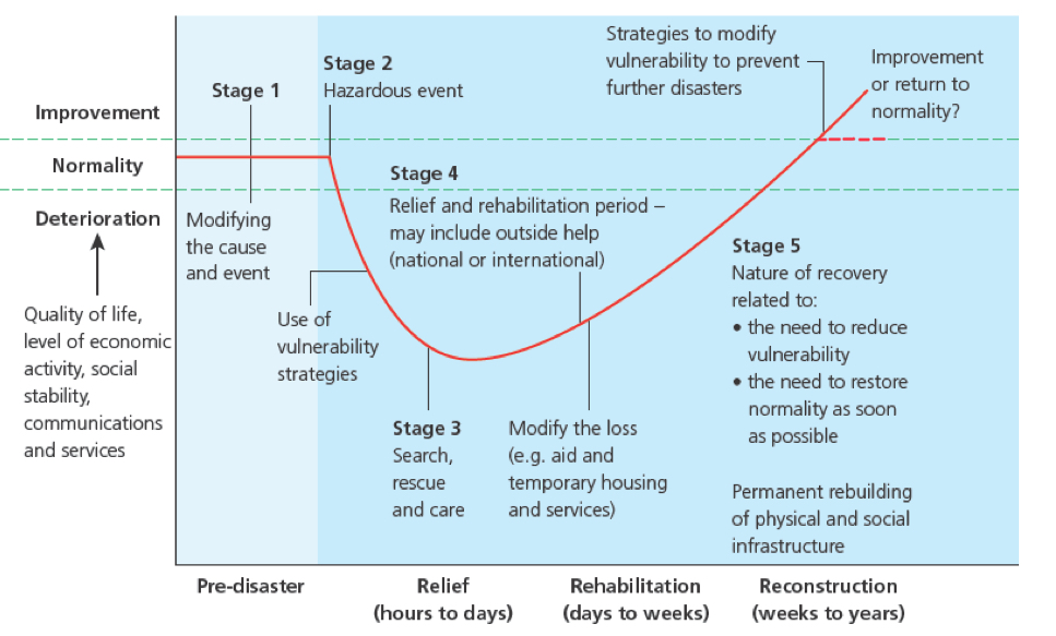
The Park model of disaster-response