Chapter 14: Groundwater Geology 111
1/140
There's no tags or description
Looks like no tags are added yet.
Name | Mastery | Learn | Test | Matching | Spaced |
|---|
No study sessions yet.
141 Terms
Groundwater is a major ___ of liquid freshwater
reservoir
Considering the hydrosphere or all of Earth's water, what percent occurs underground?
six-tenths of 1 %
stored in rocks and sediments beneath Earth's surface is a vast quantity
Groundwater represents the largest ____ of freshwater that is readily available to humans. Its value in terms of economics and human well-being is incalculable.
reservoir
Groundwater is important as an erosional agent
1. the dissolving action of groundwater slowly removes soluble rock such as limestone, allowing surface depressions known as sinkholes as well as creating subterranean caverns.
2. form of storage that sustains streams during periods when rain does not fall.
Groundwater: A basic Resource
Water is basic to life. It has been called the bloodstream of both the ___ and ____.
biosphere and society.
We use 349 billion gallons of freshwater
77% comes from ___ ____.
23 % comes from ___.
surface waters, like lakes and rivers
groundwater in pore spaces and fractures
As water is withdrawn from a well, the connected pore spaces and fractures act as a ___ that allows water to gradually move from one part of the hydrologic system to where it is being withdrawn.
piepline
Concept 14.1
What percentage of Earth's total freshwater supply is groundwater?
14.6%
What share of Earth's liquid freshwater is groundwater?
94%
Concept 14.1
List two geologic roles that groundwater plays.
1. erosional agent
2. is a form of storage that sustains streams during periods when rain does not fall
Concept 14.1
What share of U.S. freshwater is provided by groundwater?
What is most groundwater used for?
23 %
for irrigation
Section 14.2 Groundwater and the Water Table
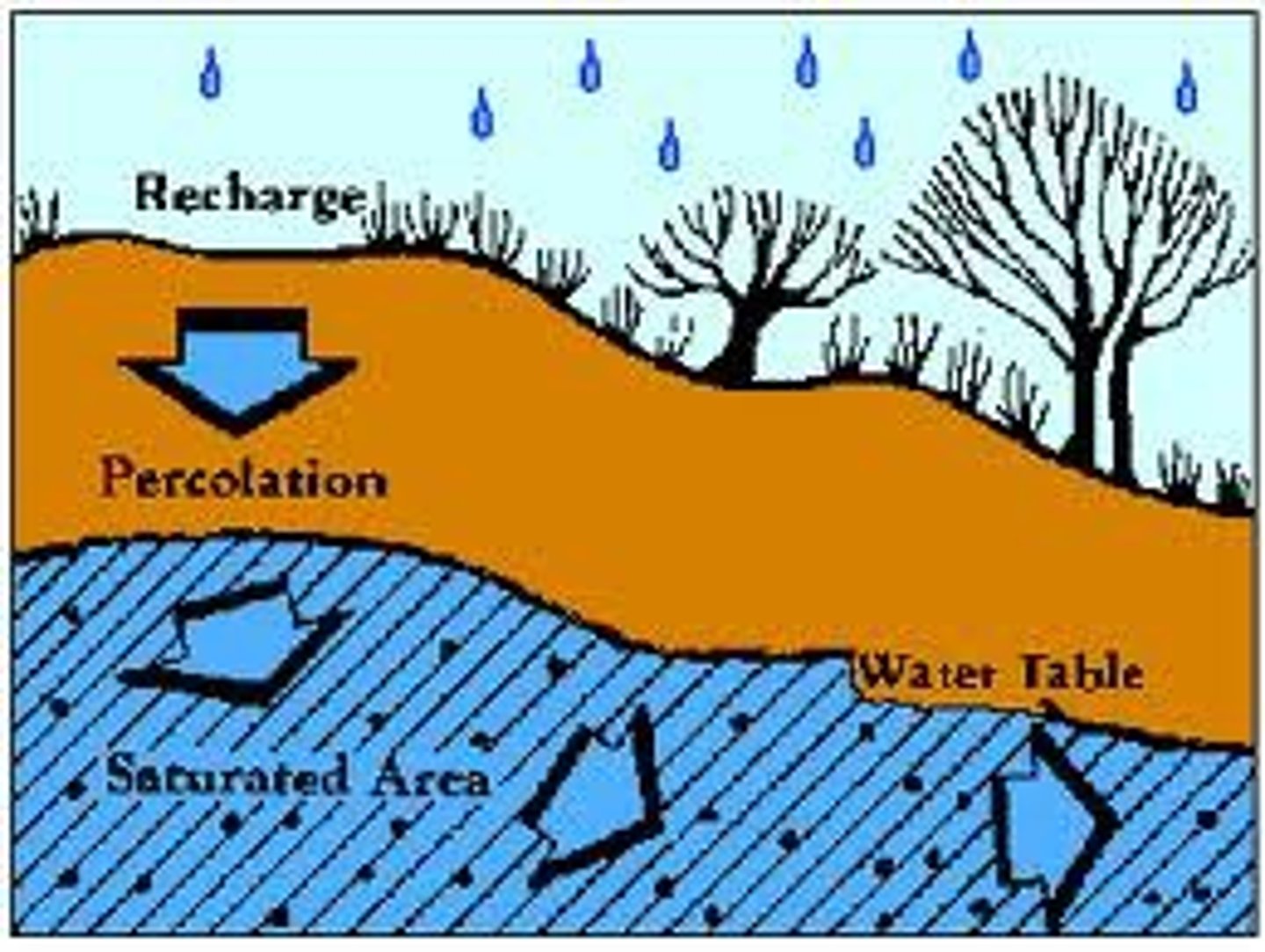
When it rains, some of the water runs off, some returns to atmosphere by evaporation and transpiration, and the remainder soaks into the ___. this last path is the primary source of all subsurface water.
ground
Distribution of Groundwater
zone of soil moisture
some of the water that soaks does not travel far because it is held by molecular attraction as a surface film on soil particles
It is criss-crossed by roots, voids left by decayed roots, and animal and worm burrows that enhance the infiltration of rainwater into the soil.
zone of saturation
water that is not held as soil moisture percolates downward until it reaches a zone where all the open spaces in sediment and rocks are completely filled with water.
also called phreatic zone
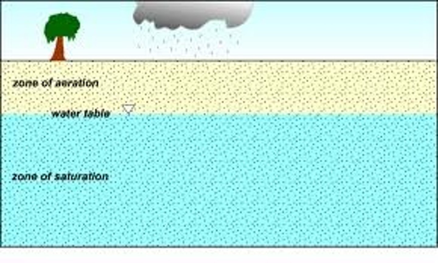
Water in the zone of saturation is called ____.
groundwater
The upper limit of this zone is known as the ___ ___
water table
Extending upward from the water table is the ___ ___. Here groundwater is held by surface tension in tiny passages between grains of soil or sediment.
capillary fringe
unsaturated zone
area above the water table that includes the capillary fringe and the zone of soil moisture
also called the vadose zone
pore spaces in this zone contain both air and water.
Although considerable amount of water can be present in the unsaturated zone, this water cannot be pumped by wells because it clings too tightly to rock and soil particles.

Below the water table, the water pressure is great enough to allow water to enter ___, thus permitting groundwater to be withdrawn for use.
wells
The Water Table
is the upper limit of the zone of saturation
significant feature of the groundwater system
is important in predicting the productivity of wells
explaining the changes in the flow of springs and streams, and accounting for fluctuations in the levels of lakes

Variation in the Water Table
The depth of the water table is highly variable and can range from ___, when it is at the surface, to hundreds of meters in some places. The water table configuration can vary seasonally and year to year
zero
Several factors contribute to the irregular surface of the water table.
1. the fact that groundwater moves very slowly and at varying rates under different conditions
2. Water tends to pile up beneath high areas between stream valleys.
3. variations in rainfall and permeability from place to place
Interactions Between Groundwater
Interactions Between Groundwater systems and streams is a basic link in the _____ cycle.
hydrologic
It can take place in one of three ways.
1. Streams may gain water from the inflow of groundwater through the streambed. Such streams are called ___ ___. for this to occur, the elevation of the water table must be higher than the level of the surface of the stream.
2. Streams may lose water to the groundwater system by outflow through the streambed. The term _____ ____ is applied. When this happens the elevation of the water table must be lower than the surface of the stream.
The third possibility is a combination of the first two: A stream gains in some sections and loses in others.
gaining streams
losing streams
Groundwater is a major source of water for __ and ___.
lakes and wetlands
Section 14.2 Concept
1. When rain falls on land, what factors influence the amount of water that soaks in?
1. steepness of slope
2. nature of surface material
3. intensity of rainfall
4. type and amount of vegetation
Concept 14.2
Define groundwater and relate it to the water table.
Water that is not held as soil moisture percolates downward until it reaches a zone where all the open spaces in sediment and rock are completely filled with water. This zone is the zone of saturation or phreatic zone. Water in the zone of saturation is called groundwater.
Concept 14.2 A kitchen table is flat. Is this usually the case for a water table? why?
Its shape is usually a subdued replica of the surface topography, reaching its highest elevations beneath hills and descending toward valleys
1. Groundwater moves very slowly and at varying rates under different conditions. (water tends to pile up beneath high areas between stream valleys)
2. In times of extended drought, the water table may drop enough to dry up shallow wells
3. Other causes for the uneven water table are variations in rainfall and permeability from place to place.
Concept Check 14.2
Contrast a gaining stream and a losing stream.
1. Streams may gain water from the inflow of groundwater through the stream bed. Such streams are called gaining streams.
2. Streams may lose water to the groundwater system by outflow through the streambed.
Section 14.3 Factors influencing the storage and movement of groundwater
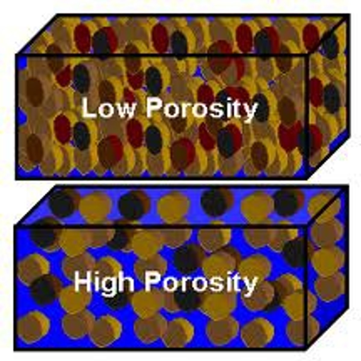
Water soaks into the ground because the bedrock, sediment, and soil contain countless voids or openings. These openings are similar to those of a sponge and are often called __ ___.
pore spaces
porosity
The quantity of groundwater that can be stored depends on the __ of the material, which is the percentage of the total volume of rock or sediment that consists of pore spaces.
permeability in rocks
is the ability to transmit a fluid
the pores must be connected to allow water flow and they must be large enough to allow flow.
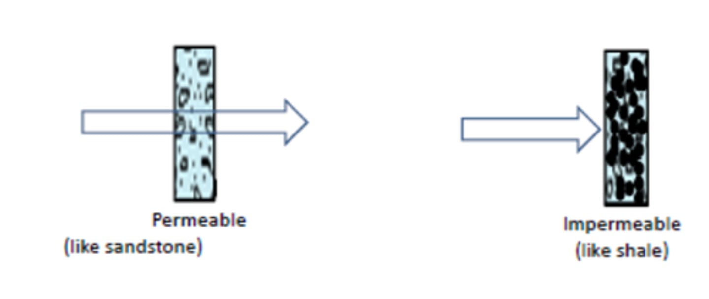
aquitards
impermeable layers that hinder or prevent water movement
clay is an example
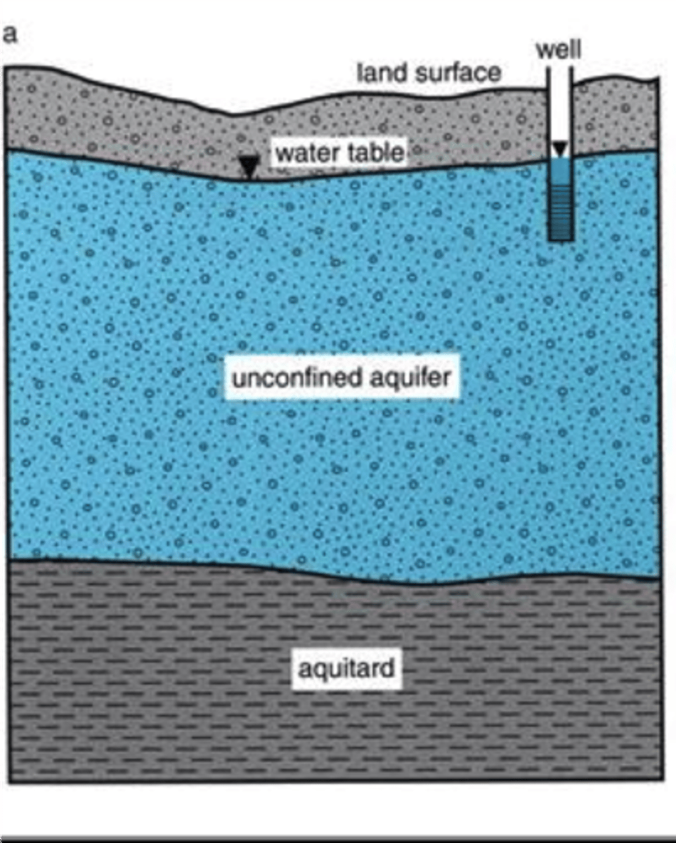
aquifers
permeable rock strata or sediment that transmit groundwater freely
ex: sands and gravels
Concept 14.3
Distinguish between porosity and permeability.
the quantity of water that can be stored in a material depends on the material's porosity (the volume of open spaces). The permeability (the ability to transmit a fluid through interconnected pore spaces) of a material is a very important factor controlling the movement of groundwater.
Concept 14.3
Distinguish between aquitards and aquifers.
Materials with very small pore spaces (such as clay) hinder or prevent groundwater and are called aquitards.
Aquifers consists of materials with larger pore spaces (such as sand) that are permeable and transmit groundwater freely.
Section 14.4 How Groundwater Moves
Groundwater exists in the pore spaces and ____ in rock and sediment.
fractures
Groundwater flow system
a three-dimensional body of Earth material saturated with moving groundwater
recharge
the water moving along flow paths from areas of __, where groundwater is replenished
discharge
along a stream where groundwater is flowing back to the surface
occurs at springs, lakes,or wetlands, and in coastal areas, as groundwater seeps into bays or the ocean
transpiration by plants whose roots extend to near the water table represents another form of groundwater discharge
wells where groundwater, is being pumped to the surface are artificial discharge areas
The energy that makes groundwater move is provided by the force of gravity. In response to gravity, water moves from areas where the water table is high to zones where the water table is __
lower.
Although some water takes the most direct path down the slope of the water table, much of the water follows long, curving ___.
paths
figure 14.10 shows water percolating into a stream from all possible directions:
Some paths clearly turn upward, apparently against the force of gravity, and enter through the bottom of the channel.
The deeper you go into the zone of saturation, the _____ the water pressure.
greater
Measuring Groundwater Movement
The velocity of groundwater flow is proportional to the ___. The steeper the slope, the faster the water moves (because the steeper the slope, the greater the pressure difference between two points.)
slope of the water table
The water table - slope is known as the _____ ____ and can be expressed as followed.
hydraulic gradient =
h1 - h2/d
h1 is the elevation of one point on the water table
h2 is the elevation of a second point on the water table
d is the distance between two points
Groundwater flows more rapidly through sediments having greater ___ than through materials having lower permeability. This factor is known as hydraulic conductivity and is a coefficent that takes into account the permeability of the aquifer and the viscosity of the fluid.
permeability
To determine discharge (Q) the actual volume of water that flows through an aquifer in a specified time the following equation is used
Q = KA (h1 - h2)/d
where h1 - h2/d is the hydraulic conductivity, and A is the cross-sectional area of the aquifer.
This expression is called Darcy's Law in honor of the pioneering French scientist- engineer.
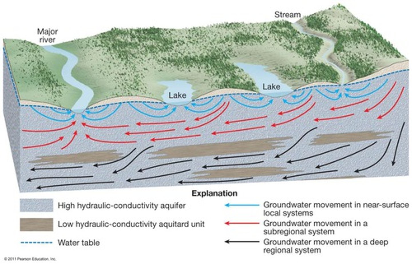
Different Scales of Movement
The diagram includes substyems at three different subsystems at three different scales. Variations in surface topography and subsurface geology can produce a complex situation. The horizontal scale of the figure could range from tens to hundreds of
kilometers
Concept 14.4
1. What factors cause water to follow the paths shown in figure 14.10
The looping flow lines result from the downward pull of gravity and the tendency of groundwater to move toward areas of reduced pressures.
Concept 14.4
2. Relate groundwater movement to hydraulic gradient and hydraulic conductivity
The velocity of groundwater flow is proportional to the slope of the water table. The steeper the slope, the faster the water moves (because the steeper the slope, the greater the pressure difference between two point). The water-table slope is known as the hydraulic gradient.
Groundwater flows more rapidly through sediments having greater permeability than through materials having lower permeability. this factor is known as hydraulic conductivity and is a coefficient that takes into account the permeability of the aquifer and the viscosity of the fluid.
Concept 14.4
3. Contrast ground movement in a near surface local system with that in a deep regional system.
The blue arrows represent water movement in several local groundwater systems that occur in the upper water table aquifer. They are separated by groundwater divides at the center of the hills and discharge into the nearest surface water body.
The black arrows show groundwater movement in a deep regional system that lies beneath the more shallow ones and is connected to them.
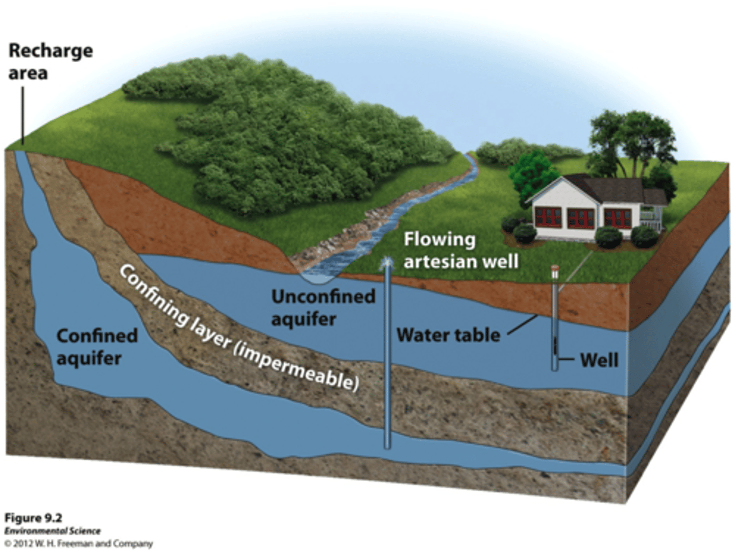
Section 14.5 Wells starts here:
1. principle source of drinking water for 50% of U.S. population
2. provides 96% of the water used for rural domestic supplies
The most common method for removing groundwater is to use a ___, a hole bored into the zone of saturation. Wells serve as small reservoirs into which groundwater migrates and from which it can be pumped to the surface.
well
Whenever water is withdrawn from a well, the water table around the well is lowered. This effect, termed _____, decreases with increasing distance from the well.
drawdown
The result is a depression in the water table, roughly conical in shape, known as the ___ ___ ___. Because of the cone of depression increases the hydraulic gradient near the well, groundwater will flow more rapidly toward the opening.
cone of depression
When two nearby wells are drilled to the same level and one is successful, it may be because there is a perched water table beneath them. A ___ ___ ___ forms where an aquitard is situated above the main water table.
perched water table
ex: massive igneous and metamorphic rocks provide a second example
Concept 14.5 Checks
1. Relate drawdown to cone of depression.
Whenever water is withdrawn from a well, the water table round the well is lowered. This effect termed drawdown, decreases with increasing distance from the well. The result if a depression in the water table, roughly conical in shape, known as a cone of depression.
concept 14.5
2. How does a heavily pumping well affect the water table?
When wells are heavily pumped for irrigation or for industrial purposes, the withdrawal of water can be great enough to create a very wide and steep cone of depression. This may substantially lower the water table in an area and cause nearby shallow wells to become dry.
concept 14.5
In Figure 14.15, two wells are at the same level. why was one successful and the other not?
It may be because there is a perched water table beneath one of them. A perched water table forms where an aquitard is situated above the main water table.
Massive igneous and metamorphic rocks provide a second example. these crystalline rocks are usually not very permeable, except where they are cut by many intersecting joints and fractures.
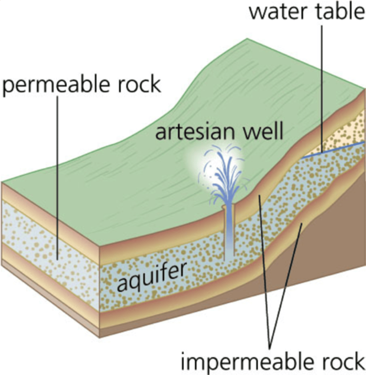
Section 14.6 Artesian System starts here:
Some wells rises, sometimes overflowing at the surface. Such wells are abundant in Artois region of northern France, and we call these self-rising wells ___.
artesian
artesian
is applied to any situation in which ground water under pressure rises above the level of the aquifer
1. water is confined to an aquifer that is inclined so that one end can receive water
2. aquitards, both above and below the aquifer, must be present to prevent the water from escaping.

confined aquifer
aquitards, both above and below the aquifer, must be present to prevent the water from escaping
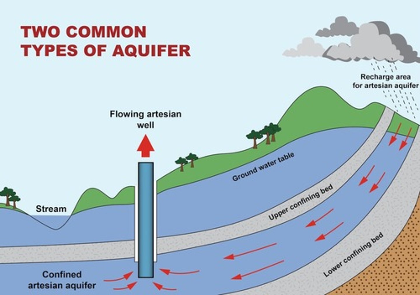
nonflowing artesian well
pressure surface is below ground level
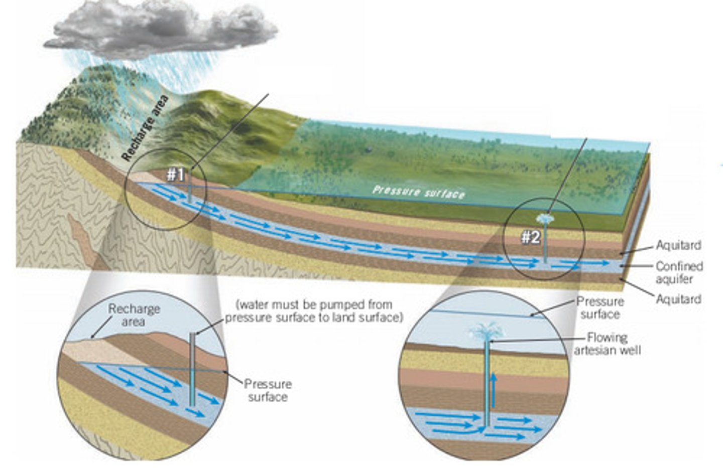
flowing artesian well
when the pressure surface is above the ground and a well is drilled into the aquifer, a ___ ___ ___ is created.
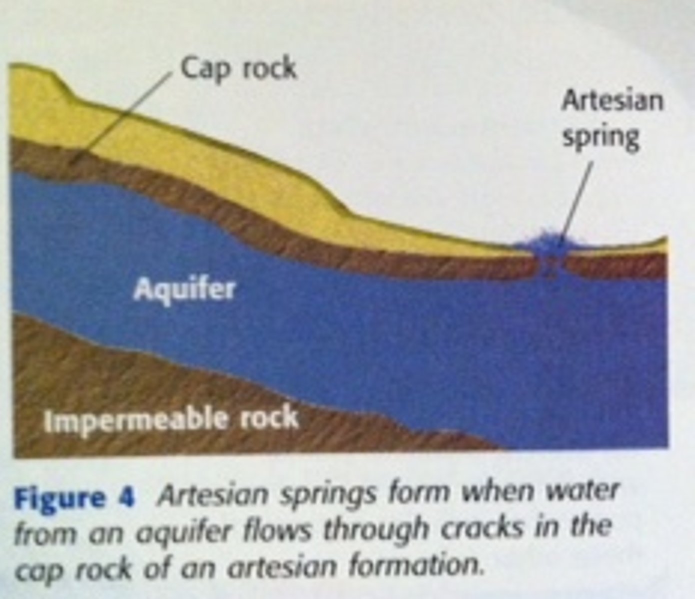
artesian springs
groundwater may reach the surface by rising along a natural fracture such as a fault rather than through an artificially produced hole.
In deserts, artesian springs are sometimes responsible for creating oases
Act as conduits, often transmitting water great distances from remote areas of recharge to points of discharge.
ex: Artesian system in SouthDakota
In the western part of the state, the edges of a series of sedimentary layers have been bent up to the surface along the flanks of the Black Hills.
City water systems can be considered examples of artificial artesian systems.
The water tower, into which water is pumped, would represent the area of recharge, the pipes the confined aquifer, and the faucets in homes the flowing artesian wells.
Concept Checks 14.6
1. Sketch a simple cross section of an artesian system with a flowing well. Label aquitards, aquifers, and the pressure surface.
Artesian wells tap into inclined bounded above and below by aquitards. For a system to qualify as artesian, the water in the well must be under sufficient pressure that it can rise above the top of the confined aquifer. Artesian wells may be flowing or nonflowing, depending on whether the pressure surface is above or below the groundwater.
artesian system
image to go with number 74

concept 14.6
2. Why do some artesian wells not flow at Earth's surface?
Because the pressure surface is below ground level.
Section 14.7: Springs, Hot Springs, and Geysers
The source of spring is ____ from the zone of saturation and the ultimate source of this water is precipitation.
water
spring
image of a spring

Whenever the water table intersects Earth's surface, a natural outflow of groundwater results and we call this a ____. Springs form when an aquitard blocks the downward movement of groundwater and forces it to move laterally. Where the permeable bed crops out, a spring results.
spring
ex: thousand springs
These well-known springs are along the Snake River in Hagerman Valley, Idaho
Springs are not confined to places where a perched water table creates a flow at the surface. Many geologic situations lead to the formations of springs, because subsurface conditions vary greatly from place to place. Even in areas underlain by impermeable crystalline rocks, permeable zones may exist in the form of fractures or solution channels. If these openings fill with water and intersect the ground surface along a slope, a ___ results.
spring
Hot springs
Water is 10 to 15 degrees F warmer than the mean annual air temperature for the locality where it occurs
ex: Warm Springs, Georgia (Presidential retreat for Franklin Roosevelt)
temp = 90 degrees Fahrenheit
ex: Hot Springs National Park, Arkansas
temp = 140 F
ex: hot springs and geysers of the Yellowstone National Park
hot springs
95% are found in the U.S. in the West
sources for the heat are magma bodies and hot igneous rocks
ex: Hot springs and geysers of the Yellowstone region

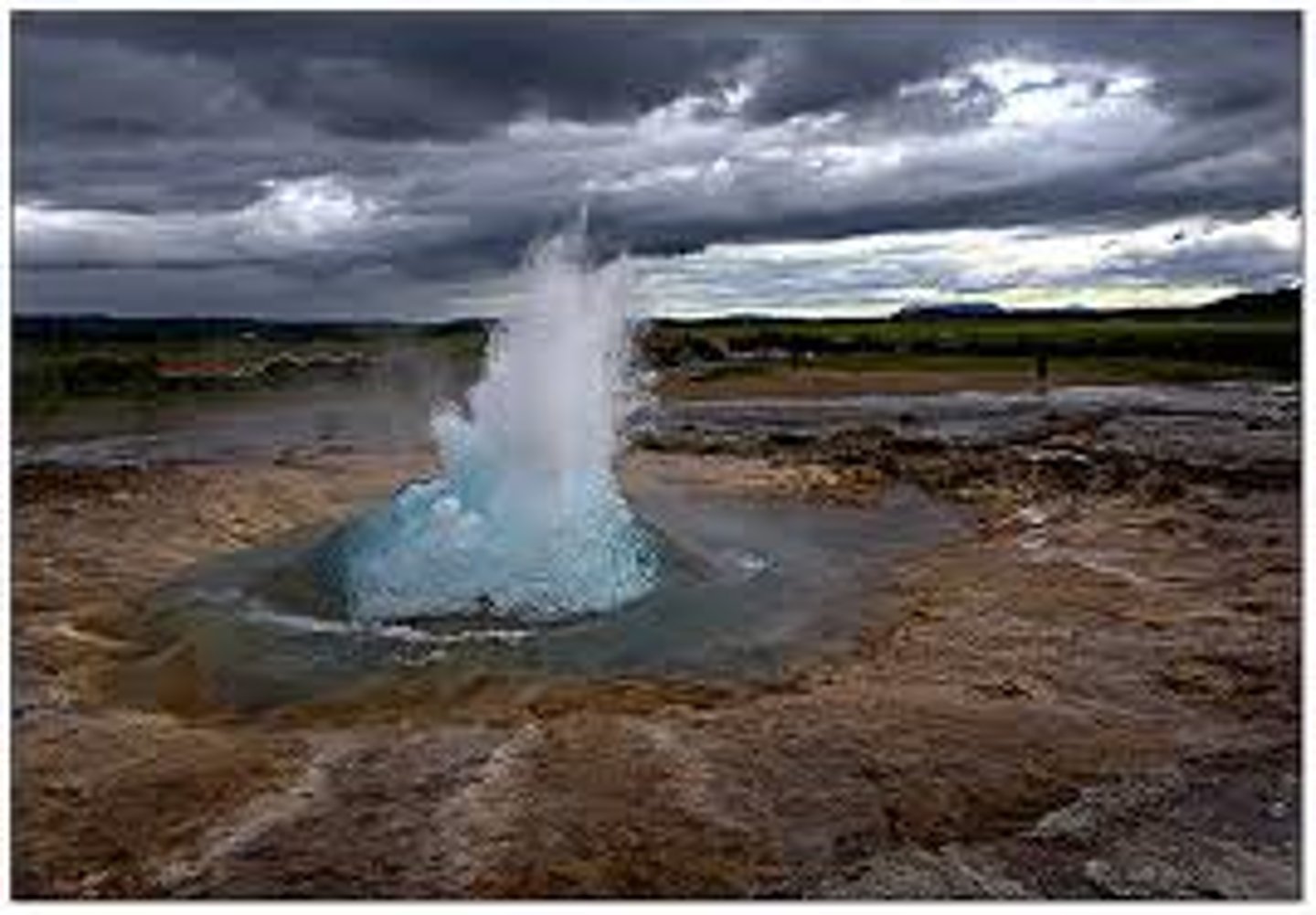
geysers
are intermittent hot springs or fountains in which columns of water are ejected with great force at various intervals often rising 100 to 200 feet
After the jet of water ceases, a column of steam rushes out, usually with a thunderous roar.
ex: Old Faithful in Yellowstone national Park
ex: New Zealand and Iceland
Icelandic word geysa means "to gush."
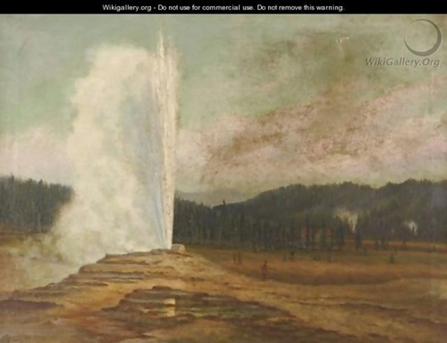
How Geysers Work
Geysers occur where extensive underground chambers exist within hot igneous rocks. As relatively cool groundwater enters the chambers, it is heated by the ____ rock. A portion of the water deep within the chamber quickly turns to steam, and the geyser erupts. following eruption, cool groundwater again seeps into the chamber, and the cycle begins
anew.
surrounding
Geyser Deposits
When groundwater from hot springs and geysers flows out at the surface, material in solution is often ____, producing an accumulation of chemical sedimentary rock.
precipitated
When the water contains dissolved silica, a material called ___ sinter or ____ is deposited around the spring.
siliceous sinter or geyserite
When the water contains dissolved calcium carbonate, a form of limestone called _____ or ____ ___ is deposited.
travertine, or calcareous tufa
The deposits of mammoth Hot Springs in Yellowstone Nationals Park are more spectacular than most others.
As the hot water flows upward through a series of channels and then out at the surface, the reduced pressure allows carbon dioxide to separate and escape from the water. The loss of carbon dioxide causes the water to become supersaturated with calcium carbonate, which then precipitates.
In addition to containing dissolved silica and calcium carbonate, some hot springs contain sulfur, which gives water a poor taste and unpleasant ___.
odor.
ex: Rotten Egg Spring, Nevada
Concept 14.7 checks
1. Describe some circumstances that lead to a formation of a spring.
1. Whenever the water table intersects Earth's surface, a natural outflow of groundwater results, and we call this a spring. Springs form when an aquitard blocks the downward movement of groundwater and forces it to move laterally. Where the permeable bed crops out, a spring results. Another example is illustrated in figure 14.15 which shows a perched water table intersecting a slope.
Concept 14.7 What warms the waters that flow at Hot Springs National Park, Arkansas, and at Warm Springs, Georgia?
The water in a hot spring is 10 to 15 F warmer than the mean annual air temperature for the locality where it occurs. In the U.S., there are more than 1000 springs.
Temperatures in deep mines and oil wells usually rise with increasing depth, an average of 45F per kilometer, a figure known as the geothermal gradient. When groundwater circulates at great depths, it becomes heated. If the hot water rises rapidly to the surface, it may emerge as a hot spring. The springs in eastern U.S. is heated in this manner.
ex: Warm Springs, Georgia
and
Hot Springs National Park, Arkansas
Concept 14.7
What is the source of heat for most hot springs and geysers? How is this reflected in the distribution of these features?
The majority (95%) of the hot springs and geysers in the U.S. are found in the west.
The sources of heat for most hot springs are magma bodies and hot igneous rocks, and it is in the West that igneous activity has occurred more recently. The hot springs of the Yellowstone region are well-known examples.
Concept 14.7
Describe what occurs to cause a geyser to erupt.
Geysers are intermittent hot springs that erupt hot water periodically. They are fed by underground chambers that fill with warm water that warms past the boiling point. Once most of the water in the chamber has been sufficiently heated, it will flash to water vapor and rapidly expand, expelling some liquid water as it forces its way to the surface in an eruption.
Section 14.8 Environmental Problems
Many people believe that groundwater is an endlessly ____ resource because it is continually replenished by rainfall and melting snow.
renewable
In some regions, groundwater has been and continues to be treated as a ____ resource. Where this occurs, the water available to recharge the aquifer falls significantly short of the amount being withdrawn.
nonrewable resource
Subsidence
The ground may also sink when water is pumped from wells faster than natural recharge processes can replace it.
This effect is pronounced in areas underlain by thick layers of unconsilidated sediments. As the water is withdrawn, the water pressure drops, and the weight of the overburden is transferred to the sediment. The greater pressure packs the sediment grains tightly together, and the ground subsides.
ex: outside the United States in Mexico City, a portion of which is built on a former lake bed.