OCR Geography A level, Coasts
1/126
There's no tags or description
Looks like no tags are added yet.
Name | Mastery | Learn | Test | Matching | Spaced | Call with Kai |
|---|
No analytics yet
Send a link to your students to track their progress
127 Terms
What is a system?
a set of interrelated objects comprising of components (stores) and processes (links) that are connected together to form a working unit or unified whole
Components of coastal system
INPUTS - including kinetic energy from wind and waves, thermal energy from the heat of the Sun and potential energy from the position of material on slopes; material from marine deposition
THROUGHPUTS - consists of stores and flows
OUTPUTS - including marine and wind erosion from beaches, rock surfaces and evaporation
When is a system equal?
When a system's inputs and outputs are equal, a state of equilibrium exists
What happens when equilibrium is disturbed?
The system undergoes self-regulation and changes its form in order to restore equilibrium - dynamic equilibrium and negative feedback
How many sediment cells are there in the UK?
11
How are boundaries defined in a sediment cell?
Topography and shape of coastline
Why is a sediment cell not a completely closed system?
Due to variations in wind direction and presence fo tidal currents = some movement of material so are regarded as largely closed systems
Where does energy come from for coastal erosion and sediment transport?
Wave action which is generated by the frictional drag of winds moving across the ocean surface
Relationship between wind speed and fetch
Higher the wind speed, the longer the fetch so the more energy the waves possess
How is longshore drift generated?
If winds blow at an oblique angle to the coast, the resultant waves will also approach obliquely and generate LSD
Do waves move forward?
Waves do not move forward, but waves impart a circular motion to the individual water molecules
What is the equation for energy in a wave?
P = H2 x T, where P is power (kW/m), H is height (m) and T is time interval between crests (s)
Characteristics of swell waves
Swell waves have a long wavelength with a wave period of 20 seconds
Characteristics of storm waves
Storm waves have a short wave length, greater height and a shorter wave period
Affect of friction of breaking waves
Friction between the seafloor and the water profoundly changes the speed, direction and shape of the waves:
- slow as they drag
- wavelength decreases, successive waves bunch up
- deepest part of the waves slows down more than the top
- waves steepen
3 types of breaking waves
spilling: steep waves break onto gently sloping beaches, plunging: kind of steep waves break onto steep beaches, surging: low-angle waves break onto steep beaches
What happens to the speed of a wave as it travels up the beach?
Speed of wave decreases due to friction
What is backwash?
The movement of water back down the beach
Characteristics of constructive waves
- Low in height
- Long wavelength, low frequency
- Spilling waves
- Strong swag
- Retains energy as not disrupted by breaking of another wave
- Lots of percolation
- Material moved onshore
- SWASH EXCEEDS BACKWASH
Characteristics of destructive waves
- Greater in height
- Short wavelength, higher frequency
- Plunging waves - little forward energy
- Swash is slowed by friction of meeting the backwash of a previous wave
- Little percolation
- Material deposited offshore
- BACKWASH EXCEEDS SWASH
Relationship between beach gradient and wave type
- High-energy waves remove material and transport it offshore, reducing beach gradient
- Low-energy waves, build up beach face, steepening the profile
How is a high tide created?
The Moon pulls water towards it, creating a high tide, and there is a compensatory bulge of the opposite side of the Earth - locations between the bulges will be at low tide
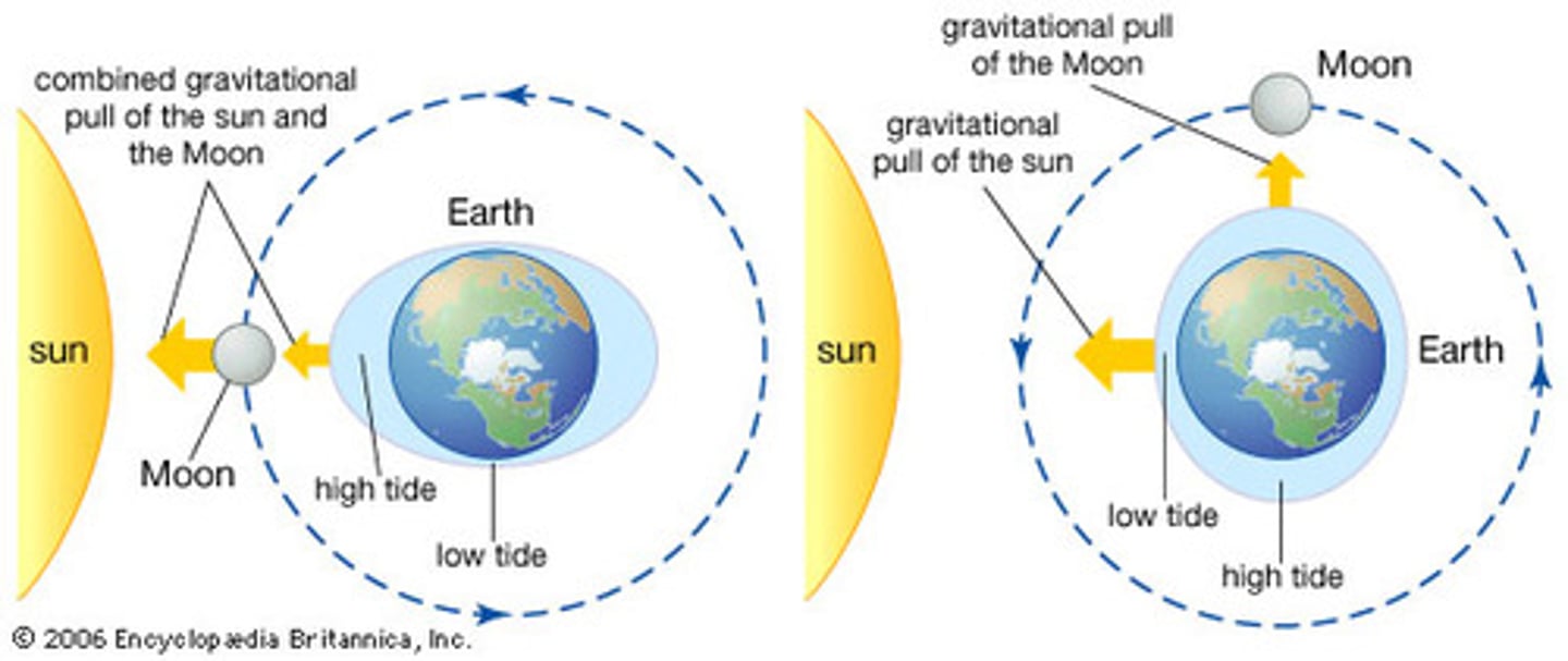
When does a spring tide occur?
When the Sun and the Moon are in alignment, occurs twice a lunar month
When does a neap tide occur?
Moon and Sun are at right angles to each other, gravitational pull is weakest, occurs twice a lunar month
How does tidal range affect development of coastal landscapes?
Tidal range influences where wave action occurs, the weathering processes that happen on land exposed between tides and the potential scouring effect of waves along coasts with a high tidal range
Influence of rock structure on rock strata
- Horizontally bedded and landward-dipping strata support cliffs with steep, vertical profiles
- Seward-dipping strata tend to follow the angle of dip of the bedding planes
Affect of rip currents of coastlines
Play an important role in the transport of sediment - caused by either tidal motion or by waves breaking at right angles to the shore
Rip currents modify the shore profile by creating cusps which help to perpetuate the rip current, channeling flow through a narrow neck (small scale)
What are ocean currents?
Masses of ocean water that flow from one place to another, much larger scale and are driven by the Earth's rotation and by convection, and are set in motion by the movement of wands across the water surface
Affect of current strength on coastal landscape
Strength of the current has little effect of the coastal landscape system in terms of geomorphic processes, but the transfer of heat energy can be significant, as it directly affects air temp and therefore, sub-aerial processes
Affect of rivers on coastal sediment budget
Rivers are major sources of sediment input to the costal sediment budget - particularly coasts with steep gradient where rivers directly deposit material
Where does sediment come from?
Erosion of inland areas by water, wind, and ice as well as sub-aerial processes of weathering and mass movement
Wave erosion and sediment budget
Wave erosion is also the source of large amounts of sediment and makes a major contribution to sediment budgets
- Cliff erosion can be increased by rising sea levels and is amplified by storm surge events (AO2: likely to get worse in the future
Constructive waves and the movement of sediment
Constructive waves bring sediment to the shore from offshore location and deposit it (marine deposition, adding to the sediment budget (tides and currents do the same)
What can be done is a sediment budget is in deficit?
Beach nourishment is one way n which a sediment equilibrium can be maintained
- Used globally to preserve and protect coastal environment
+ Sustainable
- Expensive
What is freeze-thaw weathering?
Water enters cracks/joints and expands by 9% when it freezes. In confined spaces this exerts a pressure on the rock, causing it to split or pieces to break off, even in very resistant rocks
What is pressure release?
When overlaying rocks are removed by weathering and erosion, the underlying rock expands and fractures parallel to the surface. this is significant in the exposure of sub-surface rocks such as granite
What is thermal expansion?
Rocks expand when heated and contract when cooled. If they are subject to frequent cycles of temperature change, then the outer layers may crack and flake off
What is salt crystallisation?
Solutions of salt can seep into the pore spaces in porous rocks. Here, salts precipitate, forming crystals. Growth of these crystals creates stress in the rock causing it to disintegrate.
What is oxidation weathering?
Some minerals in rocks react with oxygen, either in the air or in water. Iron is especially susceptible to this process. It becomes soluble under extremely acidic conditions and the original structure is destroyed. It often attracts the iron-rich cements that bind sand grind together in sandstone.
What is carbonation weathering?
Rainwater combines with dissolved carbon dioxide in the atmosphere to produce a weak carbonic acid. This reacts with calcium carbonate in rocks such as limestone to produce calcium bicarbonate, which is soluble
What is solution weathering?
Any processes by which a mineral dissolves in water is known as solution
What is hydrolysis weathering?
This is a chemical reaction between rock minerals and water. Silicates combine with water, producing secondary minerals such as clays. Feldspar in granite reacts with hydrogen in water to produce china clay
What is hydration weathering?
Water molecules added to rock minerals create new minerals of a larger volume. This happens when anhydrite takes up water to form gypsum. Hydration causes surface flaking in many rocks, partly because some minerals also expand by about 0.5% during chemical change because they absorb water
Tree roots as a form of biological weathering
Tree roots into cracks or joints in rocks and exert outward pressure. When trees topple, their roots can exert leverage on the rock and soil, bringing the to the surface and exposing them to further weathering. Burrowing animals may have a similar effects. This may be particularly significant on cliff tops and cliff faces
Organic acids as a form of biological weathering
Organic acids produce during decomposition of plant and animal litter cause soil water to become more acidic and react with some minerals. Blue-green algae can have a weathering effect, producing a shiny film of iron and manganese oxides on the rocks. On shore platforms, molluscs may secrete acids which produce small surface hollows in the rock
What is rockfall?
On cliffs of 40 degrees or more, rocks may become detached from the slope by physical weathering processes. these rocks then fall to the foot of the cliff under gravity. Wave processes rove this material, or it may accumulate a a relatively straight, lower, angled scree slope
What are slides?
These may be linear, with movement along the slip plane. Rotational slides are known as slumps. On coasts, slides occur due to undercutting by wave erosion at the base of the cliff which removed support of the materials above
Define waves
Waves are a source of energy in coastal landscapes, and when they beak onshore, the energy can be expended through geomorphic processes to shape landscapes. They can also supply material to the system in the form of sediment, which is either deposited in or transported within the system
What is abrasion?
When waves hurl stones at the coast and scour the coastline
What is attrition?
When rocks collide with each other and become worn away. They become smoother, more round and small. Eventually producing sand
What is hydraulic action?
Air may become trapped in joints and cracks on a cliff face. When a wave breaks, the trapped air is compressed. When the wave recedes, pressure is released, the air suddenly expends and the crack is widened
What is pounding?
When the mass of a breaking wave exerts pressure on the rock causing it to weaken
What is solution (transportation)?
Minerals have been dissolved into mass of moving water. Minerals will remain in solution until water is evaporated and they precipitate out of solution
What is a suspension (transportation)?
Small particles carried by currents
What is saltation (transportation)?
Series of irregular movements of material which are too heavy to be carried continuously in suspension. Turbulent flow causes material to be picked up and carried for a short distance to be dropped again (bouncing)
What is traction (transportation)?
The largest particles in the load may be pushed along the seafloor by the force of the flow (rolling)
What is longshore drift?
When waves approach the coast at an angle due to the direction of the dominant wind. When the waves have broken, the swash carried particles diagonally up the beach. Under the influence of gravity, the backwash moved them perpendicularly back down the beach. If this movement is repeated, the net result is a movement of material along the beach. This also leads to the attrition of beach sediment, so particles tend to become smaller and more rounded with increasing distance along the beach.
When does deposition tend to occur?
- When the rate of sediment accumulation exceeds rate of removal
- When waves slow down immediately after breaking
- At the top of the swash, where for a brief moment, water is no longer moving
- During backwash, when water percolates
- Low energy environments
What is settling velocity?
The velocity at which sediment particles are deposited
Describe fluvial deposition
- As rivers enter the seam there is a reduction in velocity as the flowing water moving through the channel enters the relatively static body of sea water.
- Available energy is reduced so some or all of the river's sediment is deposited
- As the reduction in energy is progressive, deposition is sequential, with the largest particles being deposited first and the finest being carried further out to sea
What causes flocculation?
Meeting of fresh and salt water causes flocculation of clay particles. These fine materials clump together due to electrical charges between them in saline conditions. As a result, they become heavier and sink to the seabed
How does wind move material?
Deflation
Describe aeolian processes (erosional) along a coastline
Sand grains are moved by surface rolling and salvation as grains are relatively heavy compared to silt and clay, they are carried in suspension, restricting erosion by abrasion
Erosive force increases with wind velocity
When is material deposited by aeolian processes?
Material carried by wind will be deposited when wind speeds fall, usually as a result of surface friction
Describe the formation of erosional landforms: cliffs and shore platforms
- When destructive waves break repeatedly on relatively steeply sloping coastlines, undercutting weakens between eh high and low tide levels where it forms a wave-cut notch.
- Continued undercutting weakens support for the rock strata above, which eventually collapses, producing a steep profile and a cliff.
- Regular removal of debris at the foot of the cliff by wave action ensures the cliff profile remains relatively steep and that the cliffs retreat inland parallel to the coast.
- Cliff profiles vary depending on their geology
- As undercutting continues, collapse and retreat also continue as the cliff becomes higher
- At the base, a gently sloping shore platform is cut into the solid rock. Although superficially appearing to be flat and even, shore platforms are often deeply dissected by abrasion due to large amounts of rock debris that is dragged along the surface by wave action
- When rock debris is too larger to be removed by the waves it will accumulate on the platform.
Relationship between size of shore platform and wave speed
- Eventually, the platform will become so wide, that produces shallow water and small waves, even at high tide.
- Friction from the platform slows down approaching waves sufficiently for them to break on the platform rather than the base of the cliff and so undercutting slows and eventually ceases - Robin Hood's Bay (500m)
Erosion of shore platforms
Shore platforms usually slop seawards angles between 0 and 3, as wave erosion can occur between the high and low tide levels. Erosion is greater at high and low tide. This explains the formation of a ramp at the high tide level and a small cliff at low tide
Explain the formation of headlands and bays
- Bays and headlands form adjacent to each other due to differing resistance to erosion
- If rocks lie perpendicular to the coastline, the weaker rocks are eroded more rapidly to form bays while the more resistant rock remains between bays as headlands - due to DISCORDANT COASTLINE
Relationship between depth of bay and erosion
A bay will be deeper is rates of erosion are higher
Define concordant coastlines
Rocks lying parallel to the coastline produce concordant coastlines
When does wave refraction occur?
As waves approach irregularly shaped coastlines, wave refraction occurs
What happens have a wave reaches a coastline?
When a wave reaches a coastline, it is slowed by friction in shallower water. At the same time, the part of the wave crest in deeper water moves faster and is not slowed so the wave bends around the headland and the orthogonal converge so energy is focussed on the headland
What are the three main sources of beach sediment?
Cliff erosion: 5%
Offshore: 5%
Rivers: 90%
Beach profile of sand beaches
- Sand produces beaches with a gentle gradient, usually less than 5 degrees, because of its small particle size means that is can compact when wet, allowing little percolation during backwash
- As little energy is lost to friction, material is carried back down the beach, resulting in a gentle gradient and the development of ripples and runnels
Beach profile of shingle beaches
- Shingle produces steeper beaches, because swash is stronger than backwash
- Upper part of the beach due to rapid percolation due to air spaces so little backwash so left at the top of the beach
What are berms?
A series of smaller ridges formed beneath the storm ridge, marking the successive high tides that follow the spring tide through to the neap tide. Following tides cannot reach these features, so they remain untouched
What are cusps?
Crescent-shaped indentations that form on beaches of mixed sand and shingle formed by a collection of waves reaching the same point and when swash and backwash are similar in strength
What are ripples?
Develop due to orbital movement of water in waves
Wave energy and beach profile
- High-energy, destructive waves remove sediment offshore and create flatter beaches, shallower water, more friction and a reduction in wave energy
- Low-energy, constructive waves transfer sediment onshore and form steeper profiles, deeper water, less friction and increase wave energy
What is a spit?
an elongated ridge of sand that projects from the land into the mouth of an adjacent bay
Explain the formation of a spit
- Generally formed by LSD occurring in one dominant direction which carries manila to the end of the beach and then beyond into open water
- The end of the spit may become recurved as a result of wave refraction around the end of the spit and the presence of a secondary wind/wave direction
- Over time, spits may continue to grow, and a number of recurved ends may develop
How does a salt marsh develop behind a spit?
In the sheltered area behind the spit, deposition will occur as wave energy is reduced. Silt and mud deposited will build up and eventually, salt-tolerant vegetation may colonise, leading to the formation of a salt marsh
What is an offshore bar?
Can develop if a spit continues to grow across an indentation such as a cove or bay, in the coastline until it joints onto the land at the other end. This forms a lagoon of brackish water on the landward side
Name an example of an offshore bar
Slapton Sands, Devon
What are tombolos?
Tombolos are beaches that connect the mainland to an offshore island. They are formed from spits that have continued to grow seawards until they reach and join an island
Name an example of a tombolo
Chesil Beach, Dorset
Where do salt marshes form?
Low-energy environments
What is a salt marsh?
an area of coastal grassland that is regularly flooded by seawater.
How does the height of a salt marsh affect the period of submergence?
The higher the marsh = the shorter the period of daily submergence and less saline the conditions
What is the gradient of a salt marsh?
Shallow gradient which slopes seawards
How does vegetation affect sediment in a salt marsh?
Greater vegetation cover = trap and stabilise sediment
What are saltpans?
Between creeks, depressions occur so water is trapped when the tide falls forming saltpans
Development of salt marshes is dependent on...
Sediment accumulation
Where does deltic sediment come from?
Rivers and tidal currents
When do deltas form?
When rivers and tidal currents deposit sediment at a faster ate than waves and tides can remove it
Where do deltas form?
Where:
1. Rivers entering the sea are carrying large sediment loads
2. A broad continental shelf margin exists at the river mouth to provide a platform for sediment accumulation
3. Low-energy environments
4. Tidal range is low
Describe the structure of a delta
1. Upper delta plain - furthest inland, beyond reach of tides and composed of river deposits
2. Lower delta plain - inter-tidal zone, regularly submerged and composed of both river and marine deposits
3. Submerged delta plain - lies below the mean water mark, is composed mainly of marine deposits and represents the seaward growth of the delta
Describe a cuspate delta
A pointed extension to the coastline occurs when sediment accumulates but this is shaped by regular, gentle currents in opposite directions
Name an example of a cuspate delta
Tiber Delta, Italy
Describe an arcuate delta
Sufficient sediment supply is available for the delta to grow seawards but wave action is strong enough to smooth an trim its leading edge