Arky 303- Southwest Pueblo
1/31
There's no tags or description
Looks like no tags are added yet.
Name | Mastery | Learn | Test | Matching | Spaced | Call with Kai |
|---|
No analytics yet
Send a link to your students to track their progress
32 Terms
Defining the American Southwest
The American southwest is often defined as stretching from Las Vegas Nevada in the west to Las Vegas New Mexico in the east, and from Durango, Mexico in the south to Durango Mexico in the north.
This large area contains both semi-arid desert and Ponderosa Pine and Mixed hardwood forests - with pronounced changes in vegetation occurring with elevation.
The Lower Pecos Valley, while not officially part of the Southwest proper, served as a frontier between the southwest and other semi-arid environments, as well as hilly regions and the southern Plains.
Linda Cordell (1984) points out that the American Southwest can be defined in the following way.
• By the presence of agriculture, farming implements, the construction and use of large multi-room “pueblos” and some public architecture.
1)a variety of ingenious methods were devised to farm maize, beans and squash under a variety of harsh environmental conditions. In addition, the large adobe pueblos constructed in areas such as Chaco Canyon, Canyon de Chez, and the Rio Grande are among the most spectacular architectural achievements in the pre Columbian world
• By the absence of formal social stratification, large cities, writing systems, and major monumental architecture on the scale of that witnessed in Mesoamerica at sites such as Tikal, and Teotihuacan
not to say that southwestern peoples lived in isolation from the events and peoples occurring in areas to the north and south of them- many areas of american southwest appear to have had strong trade and exchange ties with groups in mexico and mesoamerica (macaw parrot feathers
Some archaeologists attribute the development of pottery and maize/beans/squash agriculture to the diffusion of these traits from Mesoamerica, while other archaeologists see them as indigenous developments
As mentioned previously, the hot, dry environmental conditions which characterize large areas of the southwest demand a flexible subsistence-settlement system - and in response, groups often “switched gears” between hunting and gathering and food production. Thus, the archaeological record of the southwest is one of extreme variability in different chronological periods - with people periodically abandoning large centers and returning to dispersed villages. Another response to the unpredictability of thesouthwestern environment was the formation of wide-ranging social networks - allowing food and people to be moved into and out of areas affected by periodic drought
Southwestern Peoples
Although the American southwest has a fairly long history of contact - with Spanish Entradas appearing at the end of the 16th century, many southwestern aboriginal peoples have managed to retain a unique sense of their own distinctive cultural identity. Anthropologists recognize four distinctive groups or cultures - based on language, and cultural differences:
• Yuman speaking peoples. f the Colorado River Valley and Baja California. These groupspracticed agriculture on the flood plains of river systems when they were able, and supplemented their food production with hunting and gathering. The Yuma were skilled warriors and traders, and established exchange networks with their Pima neighbors to the south, as well as groups living on the Pacific Coast
• Pima, Papago and other peoples living in southern Arizona, Sonora, and parts of northern Mexico. These groups are Uto-Aztecan speakerswho live in an environment characterized by both inhospitable deserts and lush river valleys.Members of these groups lived in small villages called racherias - consisting of several related nuclear families living in separate dwellings
• Pueblo Indians (Zuni, Acoma, Laguna, Hopi). of Arizona and New Mexico - groups who share a common culture, yet speak different languages. Pueblo groupsconsist of the Zuni, Acoma, Laguna, and Hopi - as well as a variety of groups speaking Keresan and Tanoan languages
Several of these languages have roots in other areas - for example, Tanoan languages are similar to some spoken on the Great Plains.
Unlike the Pima and Papago, Pueblo groups live in nucleated settlements consisting of large, multi-room structures known as pueblos.
Pueblos were constructed of adobe and stone, and often consisted of rooms of various purposes; for example, living quarters, storage, and ceremonial rooms known as kivas.
There are important socio-political differences between various Pueblo groups - for example, while the western Pueblo groups are matrilineal and exogamous, those of the east are organized around matrilineal bilateral extended families and non-exogamous moieties. If a society is divided into exactly two descent groups, each is called a moiety, after the French word for half.
The leaders of moieties and ceremonial groups associated with kivas coordinate tribal activities at the level of sociopolitical organization above the local family.
• Apache and Navajo- Athapaskan groups originally from Northern Canada that moved into the Southwest sometime during the 16th century; perhaps as early as AD 1450. The white River Ash Eruption of Mount Churchill in eastern Alaska blanketed large areas of the Yukon and NWT that occurred 1200 years ago, and may have stimulated the movement of Athapaskan speaking groups out of these areas and south towards the southwest. This may explain the origins of the Apache and Navajo.
The Southwestern Environment
• Physiography.
straddles several physiographic zones and consists of both mountain ranges to the south and west, and several large basins. the landscape is broken up by mesas and steep sided canyons. Volcanic deposits in many areas provided groups with access to obsidian - an important lithic raw material source.
Along the edges of mountains and rivers, groups took advantage of moister environmental conditions and engaged in agriculture
• Precipitation. Precipitation is extremely seasonal and highly localized - making broad generalizations aboutclimatic conditions during the Holocene difficult
• Weather Patterns.
The extreme variability in weather patterns throughout the southwest necessitates that plants remain dormant until moist conditions allow them to flower or bear fruit. As a result, human groups had to remain highly mobile - foraging over large areas in search of foodstuffs.
• Biogeography.
Animals such as mule deer, prong horn sheep, and rabbits were hunted - as were birds, especially in marshland settings. Fish were also taken in many of the large rivers. Regardless, maize formed the most significant portion of the subsistence base of many southwestern groups - especially from the late archaic onwards into Pueblo times
• Agriculture
Agriculture was often limited by summer temperature, surface evaporation rates and the length of the frost-free season. Under such conditions, maize takes longer to mature, and therefor must remain in the ground for longer periods of time
As a result of such variations, farmers devised a number of techniques to minimize the risks associated with crop failure - including the controlled use of water, and the careful placement of gardens
Conceptual Frameworks- pecos
The Pecos Classification System represents one of the first developmental frameworks for understanding prehistoric culture change. Developed by A.V Kidder in the 1930’s,
Basketmaker I - a pre-agricultural stage no longer used as this period is now subsumed under the label “archaic”
Basketmaker II - where people were farming and using atlatls (spear throwers)
Basketmaker III - associated with the development and use of ceramics, and the construction of pit houses
Five Pueblo stages (I-V) which track the emergence of Pueblo culture into historic times Kidder referred to this northern tradition as Anasazi - a Hopi Indian word meaning “the old ones”. Now, the preferred term is “Ancestral Pueblo”.
Over the years, however, the Pecos Classification Scheme has been expanded and now includes many southern areas of the southwest.
The Scheme has been widely criticized for a number of reasons:
• First, it portrays the development of southwestern cultural traditions as linear and ladder-like. We know now that much more cultural variation exists in the American Southwest.
• Second, it is based on pottery styles that are assumed to have been manufactured at individual villages and rarely traded from one region to another. In actuality, archaeologists now know that pottery was manufactured locally and traded over extremely large areas of the southwest.
Conceptual Frameworks
Today, southwestern prehistory is understood within a broad cultural framework which includes the Paleo-Indian Period (prior to 5500 BC); the Southwestern Archaic (5500 BC and AD 200); and the so-called Pueblo cultures which flourished after this time period. This later time period in southwestern prehistory is often divided up into four chronological phases or culture periods:
• Anasazi (Ancestral Pueblo): (? AD to modern times).The Anasazi tradition flourished in the northern Southwest and subsumes the old Basketmaker-Pueblo developmental scheme. Such major developments as Chaco Canyon and Mesa Verde with their magnificent pueblo architecture lie within the Anasazi tradition. Now referred to as “Ancestral Pueblo”
• Hohokam (AD 1400 to modern times). The Pima word “Hohokam” means “those who have gone”. The Hohokam tradition differs from Anasazi in its rectangular, single unit dwellings, low platform mounds, ball courts, cremations, and a reliance on extensive irrigation systems and paddle-and- anvil decorated pottery. This tradition flourished in the southern desert regions of the southwest, and has been subdivided into as many as six different periods at various times. Irrigation canals, ball courts, platform mounds, and elaborate pottery, stone, and shell working are all characteristic of Hohokam at the height of its development. connections with mexico.
• Mogollon (AD 150 to AD 1450. This tradition is centered around the mountains of southeastern and western New Mexico, and its name is taken from a Spanish Colonial administrator who served in this area. The Mogollon are renowned for their distinctive red-on-brown and polished red Mogollon ceramics which are found over a large area. The Mogollon period is associated with a great deal of variation, and as a result, it has been subdivided into several stages based on changing pithouse designs and ceramic styles.
• Patayan ( 850 AD to modern times). “Patayan” comes from a Yuman word meaning “old people” and it is used to describe prehistoric peoples who once occupied the areas west of the Hohokam and north to thevicinity of the Grand Canyon. Patayan is still, however, weakly defined as a prehistoric culture - and much more work needs to be done on it. It should be noted that these characterizations are meant to be very broad generalizations of the considerable variability that has been noted for the southwest
Southwestern Archaic
• Oshara Tradition (c.5500BC to AD.600).
• San Dieguito-Pinto Tradition (c.8200BC to 6000BC).
• Cochise Tradition. (5000BC to 200BC)
Three traditions define the Southwestern Archaic.
• Oshara may be ancestral to Anasazi
• San Dieguito-Pinto may be ancestral to Mogollon
• Cochise may be ancestral to Hohokam
The Oshara Tradition (5500BC to AD.600)
Located in New Mexico, southern Colorado, and Southeastern Utah.
•Jay Phase (7,450 to 6,750 years before present) – Artifacts of hunter-gatherers, distinguished from earlier Paleo-Indians, and evidence suggests that people concentrated on hunting and gathering of locally available game and food, often living near canyon heads. Artifacts found include crude stone tools for processing food and long, narrow projectile points
•Bajada Phase, (6,750 to 5,150 years BP) – Distinguished from the Jay phase by the presence of different projectile points, different hearths, ovens, and more sites)
•San Jose Phase (6,750 to 3,750 years BP) – Metates and manos were used to process food. There was an increase in both the size and number of sites during this period. Trash heaps were also now found
•Armijo Phase (3,750 to 2,750 years BP) – Cultivation of maize began during this period which allowed for food surpluses. A new type of site was introduced, a seasonal site for gathering of up to 50 people, believed to be possible due to the stores of cultivated maize. Irwin-Williams concluded that the Oshara may have been the first Southwestern culture to cultivate crops. Projectile points were different from the concave, short projectile points of other cultures of the northern Colorado Plateau during this time, the Middle Archaic period. Late in the phase the points were serrated, stemmed blades
•En Medio Phase (2,750 to 1,550 years BP) – During this period there was again an increase in the number of sites, but generally now at the base of cliffs, and the introduction of the use of storage pits for surplus food. It was roughly analogous to the southwestern Basketmaker culture
•Trujillo Phase Trujillo phase (starting about 1,550 years BP) – Pottery was introduced during this period.
Oshara eventually becomes the Anasazi
The Oshara may have ancestral roots in earlier Paleo-Indian traditions, but these postulated roots are much disputed and the debate is currently unresolved. It is considered as a transitional period between PaleoIndian and Archaic in the Rio Grande Basin. The beginnings of Oshara to about 5500 BC, as dated by Cynthia Irwin-Williams, then developed a sequence of Archaic culture for Oshara in the Arroyo Cuervo area of north central New Mexico. This sequence defines no fewer than six phases of occupation, each identified by Projectile point forms and other less well defined artifacts
San Dieguito- Pinto Tradition (c.8200BC to 6000BC)
• Located in southern California and northwestern New Mexico.
• Abundant scrapers
• Large percussion bifaces
• Scarcity of milling stones (manos and metates).
• Absence of small projectile points and pottery
The San Dieguito-Pinto Complex is an archaeological pattern left by early Holocene inhabitants of southern California and surrounding portions of the southwestern United States and northwestern Mexico. Radiocarbon dating places a 10,200 BP (Before Present) (8200 BCE) date consideration. Based on these findings, this tradition exploited nearby coastlands and marchlands, which is a very different type of environment than in other regions of the southwest. Of course, it was marshlands and not coastlines that were exploited in New Mexico. San Dieguito may become Mogollon 24
Cochise Tradition. (5000BC to 200BC)
The Cochise Tradition (also Cochise Culture) refers to the southern archeological tradition ofthe four Southwestern Archaic Traditions, in the present day Southwestern United States(? before 5000 to c. 200 BC) lasted for a very long time, with its earliest manifestations, Sulphur Spring, perhaps before 5000 BC. Its two later phases, the Chiricahua and San Pedro, are much better known. named after Lake Cochise, an ancient lake which is now Willcox Playa in Cochise County, Arizona. appears to ancestral to the prehistoric Mogollon (Mimbres) and Hohokam traditions.
• Located in southwestern US.
• Chiricahua Phase: Variety of points and seed processing tools. The phase has been dated to between about 3500 and 1500 BC, but the chronology is open to doubt and the beginnings may be much earlier, and has been formulated on the basis of occupations in Ventana Cave, near Sells, Arizona, and from other locations in the state, as well as in western New Mexico
• San Pedro Phase: pithouses; semi- permanent settlements; cultivation of maize crops. San Pedro follows the Chiricahua in the southern Southwest, characterized by large projectile points with corner or side notches and straight or convex bases. Provisional radiocarbon dates have San Pedro flourishing from about 1500 to 200 BC. By this time, the Archaic population of the Southwest appears to have grown, with groups exploiting a wider range of environmental zones and sometimes living in larger, perhaps more permanent, settlements. Some San Pedro sites contain oval pithouses excavated about 1.6 ft. below the ground level, dwellings requiring sufficient effort to build that they must have been occupied for some time. Without question, some of San Pedro communities were cultivating maize and other crops.
*Coschise may become Hohokam and Chihuahua cultures of northern Mexico* (?) 25
The Southwestern Archaic (before 7500 BC to AD 200)
With the onset of the Middle Holocene, warmer climatic conditions produced vegetation patterns which approached their modern distributions
• Use of domesticated plants to supplement foraging lifestyle .As conditions became warmer, hunter gatherers replaced their generalized subsistence strategy with one that was much more specialized. he archaic is an important formative period in southwestern prehistory as groups began to experiment with domesticated plants as a means of supplementing their hunting and gathering lifestyle.
• Archaic remains known from dry rockshelters and caves. as well as small pithouse villages which dotted the edges of intermountain basins
• Formation of pithouse villages during Basketmaker times. Work by Fred Plog on the Colorado Plateau demonstrates that the formation of pithouse villages during the Basketmaker (archaic) phase of southwestern prehistory were episodic. Plog speculates that weakly developed political institutions external to the family prevented villages from fractioning off because conflicts and the redistribution of foodstuffs could not be regulated efficiently
Systems of Regional Integration: AD. 900-1150
• Northern southwest dominated by regional system of interaction.
• Centered at Chaco Canyon (11th century).
• Similar systems developed among other groups.
• Despite this, most people lived in more simply organized communities.
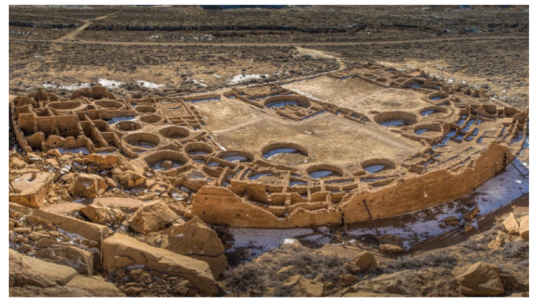
The Chaco Phenomenon
• Chaco interaction sphere: 53,107 km.
• Large planned towns.
• Water control features, roads
• Luxury items.
• Chacoan outliers. sites situated physically outside of Chaco canyon, but that express connections to Chaco by roadways and visual systems of communication (signal towers), Chacoan style masonry and ceramics, Great Kivas or Tower Kivas.
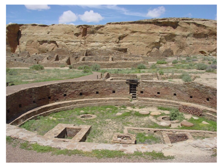
Chetro Ketl
An image of the ruins of Chetro Ketl in Chaco Canyon (New Mexico, United States); shown is the complex's great kiva
Pueblo Bonito
Hosta Butte Phase Villages
Towns verses Villages The difference between town and villages sites in Chaco Canyon has always been a bit of a puzzle for archaeologists. Hosta Butte Phase villages and Bonito Phase towns were originally thought to represent different time periods, with Hosta Butte Villages giving rise to later Bonito Phase towns. However, using tree ring dating, Florence Hawley Ellis was able to demonstrate that these two phases were, in fact, contemporaneous
• Smaller and appear to have grown by accretion. They average 16 rooms in size, are generally single-story structures oriented southeast, and they appear to have grown accretionally.
• Small rooms and small kivas. Rooms are typically small with low ceilings, plazas open and unroofed, and kivas are small. Great Kivas are not usually associated with Hosta Butte Phase villages, but a single Great Kiva known as Casa Rinconada appears to have served a small cluster of Hosta Butte villages.
• More numerous in the vicinity of Bonito towns. Hosta Butte Phase villages also appear more numerous in the vicinity of Bonito towns and Chaco outliers, and lack tower kivas and exotic materials such as copper bells, macaws, and cylindrical vases. Finally, the room to kiva ratio is approximately 6.5 to 1
Bonito Phase Towns
• Planned communities. constructed by large labor pools. They average 216 rooms with a kiva to room ratio of 1 kiva for every 29 rooms. Bonito Phase towns consist of multi-storied buildings with cored-veneer masonry that were oriented south. Plazas are almost always enclosed by rooms or high walls, and kivas are enclosed using cribbed log roofs comprised of finely hewn pine logs brought in from great distances. Each of the nine Bonito towns within Chaco Canyon has one Great Kiva associated with it.
• Great Kivas. Chacoan Great Kivas are both unusual and unique in terms of their size and distinctive floor features. Entrance to the kiva was gained through a recess or underground passage and inside, fire boxes, bench seats, and masonry vaults would have been oriented north-south. Great Kivas.Along the walls of the kiva would have been recesses or crypts used for offerings of strings, stones, and beads. Estimates of the original wall height of the Great Kiva at Pueblo Bonito suggest 3.35m, and given the size of the structure, this indicates that it would have required a great deal of effort to construct. Fourteen tower kivas (multi-storied kivas) have also been documented at Bonito Phase sites and are often incorporated within a room block
• Absence of burials. One of the most puzzling features of Chaco Canyon is the absence of burials. James Judge estimates that 4700 to 5400 deaths would have occurred during the time period associated with the Chaco Phenomenon. Yet, we only have between 50 and 60 individuals associated with Bonito Phase construction. Bonito Phase towns are always located along the north wall of the Canyon. While this would have put them at considerable risk due to flooding of the Chaco wash, it had the effect of maximizing their exposure to solar radiation, making the pueblos more comfortable to occupy during the winter months
• Signal towers used as system of communication. These stations are placed in the line of site ofseveral Bonito towns, and during a recent experiment using railroad flairs, archaeologists found that line of site communication could bemade between a signal station and its two nearest neighbors. Another Bonito feature associated with the north side of the canyon is a system of water control features consisting of head gates, dams and water control ditches
• Chacoan road system.that snakes out from the canyon proper and outwards towards Chacoan outlier sites. While the Chacoan road system was known to the Navajo, archaeologists have only recently begun to study them. road system does not follow topographic contouring. When a major topographic obstacle such as a cliff is encountered, a series of steps with finger holds were carved into the wall to assist its ascent. Likewise, other obstacles were navigated using sharp angular turns rather than gentle curves.There is also a great deal of variation in terms of the preparation of the roads. The widths of roadways are also important with major roadways averaging 9.5 meters and minor ones 4.5m.
Trails or Roads?: Some of these roads lead to Chacoan outliers while others lead to resource areas. The length of these roads and their standardization make them unlike any other Indigenous trail system north of Mexico
Chacoan Outliers
• Any site found with ties to Chaco Canyon which is found outside of the Canyon proper.
• Core-veneer masonry, Chaco ceramics.
• Connected via roads or signal towers. and they all have great kivas, tower kivas or both. Excavations at Salmon Ruin, near Bloomfield New Mexico reveal that the site was occupied by both local groups and Chacoan immigrants, who seem to have supervised special purpose activities that occurred at Salmon Ruin. These activities seem to have included the processing/milling of flint corn. the absence of burial information makes comments on social stratification within the Chacoan system impossible to establish
• Presence of site hierarchy. with sites in the Canyon proper being the most important followed by outliers, and then the small non- Chaco affiliated sites that surrounded the outliers.
Development and Collapse of Chaco Canyon
What caused the Chaco Phenomenon to develop? And why did it only last for 300 years?
Does Chaco represent an attempt to pool risk and manage uncertainty?
Did it develop as a central place through interactions of adjacent groups?
Do all pueblo societies move through periods of aggregation and dispersal?
base upon the idea that pueblo societies move through a series of developmental stages - from dispersed to aggregated and then to nucleated. Each of these three stages is associated with a different level of internal integration. Of these three stages, Irwin-Williams considers the nucleated stage at Chaco Canyon to be the most fragile and short lived, while the aggregation pattern was more resilient and flexible. Aggregated settlement patterns mean more site autonomy and less rigid control, and this is reflected at Salmon Ruin, a Chacoan outlier site I mentioned earlier on.
Development and Collapse of Chaco Canyon- What caused the Chaco Phenomenon to develop? And why did it only last for 300 years?
Many of the scion communities in the Chacoan system were constructed late in the Chacoan period, leading some archaeologists to suggest that they may represent attempts to:
Increase the carrying capacity of the canyon by moving people out of the canyon proper, or establishing sites in new areas to provision the canyon core. This would have been triggered by growing population densities in the Canyon.
A response to factionalism within the Canyon leading to out migration.
As an organized effort to develop logistical nodes along roadways.
Thus, the establishment of outliers may have been an extension of an existing pattern that, earlier on, lead to the emergence of Bonito Phase architecture
James Judge suggests that by AD 500 to 900, population densities were increasing in the Canyon. In response, pithouse groups seem to have abandoned the mesa top in favor of the settlement of the lower canyon. With hunting and gathering opportunities limited by competition for resources, residents may have attempted to increase their commitment to agriculture.
Development and Collapse of Chaco Canyon- Does Chaco represent an attempt to pool risk and manage uncertainty?
Does Chaco represent an attempt to pool risk and manage uncertainty?
food production in the Canyon is a risky endeavor due to rainfall patterns, residents may have attempted to “pool” the risk of bad crop years by storing foods in a central repository for redistribution
This, of course, would have required some sort of managerial mechanism. The construction of three sites in the 10th century: Pueblo Bonito, Penasco Blanco, and Una Vida may have served these purposes. Expansion of this risk pooling network would have likely occurred during periods of resource stress, and would eventually have evolved into a canyon wide network that would eventually reach out to areas beyond.
Development and Collapse of Chaco Canyon-Did it develop as a central place through interactions of adjacent groups?
Did it develop as a central place through interactions of adjacent groups?
In this model, the great pueblos of Chaco Canyon represent a sort of disembedded capital which is governed by an authority representative of autonomous regional governments in other areas. There are a number of problems with this idea, however, and perhaps the most important is that we have no evidence of centralized authority outside of the Canyon in outlying areas before the 10th century
Development and Collapse of Chaco Canyon-Do all pueblo societies move through periods of aggregation and dispersal?
Do all pueblo societies move through periods of aggregation and dispersal?
base upon the idea that pueblo societies move through a series of developmental stages - from dispersed to aggregated and then to nucleated. Each of these three stages is associated with a different level of internal integration. Of these three stages, Irwin-Williams considers the nucleated stage at Chaco Canyon to be the most fragile and short lived, while the aggregation pattern was more resilient and flexible. Aggregated settlement patterns mean more site autonomy and less rigid control, and this is reflected at Salmon Ruin, a Chacoan outlier site I mentioned earlier on.
During the later Mesa Verde occupation, there is a fundamental re-organization of living space within the pueblo, including the use of inferior masonry.
Many of the special purpose rooms become more general purpose, there is an increased use of wild plant foods over maize, and a greater use of local materials.
So, it would seem as though the tight rein that Chaco Canyon holds over sites outside of the canyon proper tends to loosen between Ad 1120 and 1220.
This may correspond with the intrusion of Mesa Verde migrants into the area. Within Chaco Canyon, we see the introduction of a new masonary style at about this time called McElmo.
The McElmo Phase is also associated with the introduction of new pottery styles like Chaco McElmo, McElmo, and Mesa Verde Black on White types.
Archaeological data suggests occupational continuity between Bonito Phase and McElmo phase, suggesting that Chacoan groups are still around, but they are not as influential as they once were.
Thus, the current interpretation of the McElmo Phase in Chaco Canyon is that it represents a change in economic affiliation towards the Mesa Verde area which was the major remaining population area following the disruption of the Chacoan System
Summary of Chaco Canyon
Models for Chacoan development:
A) Economic and political centralization due to resource stress
B) Consolidation of economic and political units outside the canyon.
C) Indirect influences from Meso-America (Aztec Pochteca)
models for Chacoan development that emphasize economic and political centralization due to indigenous population growth and resource stress leading to expansion out from the Canyon, and we have models that see Chaco Canyon develop in the eastern Anasazi area outside of the Canyon, where different groups consolidate economics and politics in a central location (the Canyon).
Added to this is a third idea which suggests that developments in Chaco Canyon were not iindigenous and local, but were the direct result of interference by Meso-American cultures.
Individuals similar to Aztec Pochteca or traders would have traveled into the American southwest, where they would have introduced such things as coor-veneer masonry, column- fronted galleries, and possibly platform mounds at sites like Chetro Ketl.
The most ardent devotees of the idea that Chaco Canyon developed indigenously do not doubt that there was contact with Mesoamerica....this is reflected in the presence of Macaw skeletons, turquoise and copper bells.
However, the degree of this influence has been disputed and is the subject of currently debate and research
Interregional Integration at Chaco Canyon
• How were so many people integrated together into one economic and socio- political system?
• Archaeoastronomy and Symmetrical Analysis of site plans.
It is not unusual for farming peoples to utilize calendars constructed using the observations of astronomical phenomenon for regulating planting and harvesting of crops.
however, at many sites in Chaco Canyon, astronomy may have also served as a basic organizing principle in life.
There are lots of lines of evidence indicating that the residents of Pueblo Bonito and other Bonito Phase sites were aware of the movement of the sun and the stars, and its relationship to the seasons.
For example, second story windows in Pueblo Bonito are positioned to permit the observation of sunrise at winter solstices. Likewise, notches on the walls of great kivas also seem to align up with the summer and winter solstice sunrise.
Interestingly, the high degree of town planning reflected in Bonito Phase sites in Chaco is also reflected in a basic north/south - east/west axis of building organization and orientation. This is reflected in the equivalency of spaces east and west of a north/south dividing line. whether this represents a metaphor for natural, social, or ideological relations is difficult to establish, but the pattern seems to be consistent throughout the canyon
• Sun Dagger on Fajada Butte.
The Sun Daggar of Fajada
The Sun Dagger is an ancient solar alignment feature located on Fajada Butte in Chaco Culture National Historical Park in northwestern New Mexico.
It consists of:
• A set of three large sandstone slabs leaning against a cliff face
• Behind them, on the wall, two spiral petroglyphs
• As the sun moves across the sky throughout the year, beams of light— “daggers”—shine through the spaces between the slabs and strike the spirals in precise ways.
• This setup forms a solar calendar tracking major solar events: summer solstice, winter solstice, and equinoxes.
How It Works
Summer Solstice
A single, thin shaft of light passes neatly through the center of the larger spiral. → A precise marker of the longest day of the year.
Winter Solstice
Two light bands bracket the large spiral.
→ Marking the shortest day of the year.
Equinoxes
A light band passes through the center of the small spiral. → Marking the midpoint between solstices. This demonstrates a remarkably advanced understanding of solar motion.
Cultural Significance
The Sun Dagger is tied to Chacoan ritual life, timekeeping, and ceremonial scheduling—especially for agricultural and ritual cycles. It parallels other ancient astronomical structures worldwide (e.g., Stonehenge, Mesoamerican sun temples). Its precision is extraordinary: the alignments appear intentional rather than accidental.
Current Status
The site became unstable in the 1980s due to increased visitor foot traffic that shifted the rock slabs. The National Park Service has restricted public access to protect it.
Today, the slabs have shifted enough that the original light patterns no longer occur, but the feature remains one of the most important examples of pre- contact astronomical engineering in North America.
1054 Supernova Petrograph
• 1054 Supernova (now Crab Nebula) above, Halley's comet below.
• photo by Ron Lussier
The Anasazi residents of Chaco Canyon were attentive to the movements of the heavens, that much is clear.
The famous Sun Dagger on Fajada Butte in the center of Chaco Canyon is a solar calendar that heralds the winter solstice when a band of sunlight passing through between two slabs intersects the center of a spiral.
A square of light floods a notch in the wall of Casa Rinconada's Great Kiva on the summer solstice, and locations marked within the Great Kiva are thought by some to create a simple stellar observatory.
There are many similar phenomena throughout Chaco Canyon and San Juan basin to the northwest. Sometimes a correlation suggests a dubious conclusion, another might seem obvious. Regardless of the validity of any particular claim, there is little doubt that the Chacoans cared about what happened above them, because there are so many correlations
Depicting Crab Nebula Supernova
If you look through a telescope tonight, in the constellation Taurus, you will see a formation we call the "Crab Nebula." This cloudy, glowing mass comprises about 90% of the remains of a supernova that first appeared here around July 4, 1054.
A supernova is the explosion of a large star. Our sun is too small to create a supernova. The star that created the Crab Nebula was much bigger. When a supernova occurs, the majority of the matter in the star is blown out at nearly the speed of light.
If you are close, you don't get to watch it very long before you are blown to bits. If you are far away, it will look like a very bright star, once the light from the explosion has taken its time to reach you.
The star that caused the 1054 supernova is about 4000 light years away, and much of the supernova's energy had diminished through space before it reached the earth. Nevertheless, on July 4, 1054, 4000 years after the Crab Nebula supernova actually occurred, a star six times brighter than Venus appeared in the sky.
It was visible on Earth at high noon, and stayed visible for 23 days. The supernova was so strong that had it occurred within 50 light years of Earth, all living things on the planet might have been destroyed.
The Chinese and Japanese record the appearance of a very bright "guest star" around this time. And if you were a Chacoan living at the same time, you would notice it, probably even record it.
In fact, on the underside of a shelf below West Mesa in Chaco Canyon, just outside the great house called Peñasco Blanco, is a panel containing three symbols: a large star, a crescent moon, and a handprint.
Halley's comet made its appearance just a few years after the 1054 supernova. If you were a Chacoan living around this time, you would definitely notice Halley's comet: its appearance threw many civilized peoples into fear. And since observing the heavens was an important aspect of Chacoan culture, you would probably record it.
Perhaps you would record Halley's comet where you depicted another one-time astronomical event: below West Mesa, near Peñasco Blanco. Below the star, hand, and moon, in a distinct panel, are three concentric circles, approximately a foot in diameter, with huge red flames trailing to the right. The flames are now so faint that black and white pictures often fail to record it.
Drawing conclusions from these correlations is speculation: we can't ask the Chacoans why they drew the things they did. But the circumstantial evidence is very strong.
Every 18 1/2 years, the moon and earth return to approximately the same positions they hadon July 4, 1054. If you happen to be in Peñasco Blanco around this time, situate yourself with a telescope under that shelf of West Mesa and look up in the sky. Wait until the moon is in a position pointed to by the fingers of the hand. And then use the diagram under the shelf to position your telescope at the large star depicted in the petrograph. Look in your telescope, and you will see the Crab Nebula.
And perhaps you will imagine how the Chacoans felt the day a visiting star appeared in their sky
Hohokam (AD 900-1150)
Hohokam
In the Sonoran desert of Arizona, a third regional system emerged between AD. 900 and 1150 among the Hohokam.
Sites like Snaketown, found in the core area of the Hohokam regional system, suggest large populations of about 630 to 1000 individuals living in a planned community
An inner habitation zone around a plaza was surrounded by a series of mounds and two ball courts. There was also an outer habitation zone. Possible prehistoric trails lead to the north and to the east, and may be analogous to Chacoan roads.
As I’ve mentioned before, all of the houses are pithouses and are more or less the same size.
However, information from Hohokam cemeteries suggests that some inequality wasbeing expressed in death in the form of the inclusion of exotic mortuary offerings, including beads, heavy bracelets and carved ornaments.
The presence of unique projectile points with finely serrated edges has lead some archaeologists to speculate that they were produced by craft specialists.
Evidence from the Gatlin site near Gila Bend indicates the possible use of special purpose ceremonial sites by Hohokam peoples during this time period.
The Gatlin site contained oval shaped Casas Grande like ball courts, platform mounds capped with caliche or lime, and an irrigation canal. the Gatlin site also revealed evidence of specialized production of shells, copper bells and a macaw skeleton.The presence of only two pithouses suggests that this was not a residential site. Some Hohokam sites possess greater numbers of unfinished objects than others, leading some archaeologists to speculate that these sites manufactured objects for trade across the Hohokam world. It is possible, for example, that finished shell objects were traded with other areas for agricultural products, but this idea is in need of further testing. Expeditionary trade seems to have been a feature of Hohokam interregional exchange networks. Within this framework, groups of traders would have traveled to different areas within the Hohokam world to exchange items. This is reflected at sites like Verde Valley, dating from 800 to 1000 AD, where pithouses consist of both northern and Hohokam styles. The following is an overview of some of the more important trends occurring within Hohokam culture:
Hohokam: The Sedentary Period (975 -1150 AD).
The following is an overview of some of the more important trends occurring within Hohokam culture:
• Extensive working of shell.
• Exotic objects from Mesoamerica. including mosaic mirrors, shell, and copper bells from Mesoamerica, obsidian, chert, and other stones, exotic pottery from all directions.
• Evidence for craft specialization and craft specialists in the production of ground stone artifacts and pottery
• Maximum extension of irrigation systems.
• More public architecture including possible dance plazas and evidence of mound rebuilding.
Hohokam: The Classic Period (1150 - 1350 AD).
• absence/decline in exotic goods. No more figurines, effigies elaborate points and pyrite mirrors. shell working increases
• aggregated settlements with adobe walls. Settlements change to aggregated villages within adobe walls
• switch to multi-roomed pueblo structures. Move from houses in pits to single adobe houses and multi-roomed pueblo structures.
• fewer ball courts/more platform mounds enclosed within compounds. Sites with platform mounds occur at 5km intervals along Classic period canals. Construction of the great house - a large multi- story house at Casa Grande. This and other similar structures have been interpreted as high status dwellings, special ceremonial structures, astronomicalobservatories, communal storage facilities, and as defensive structures. inhumation burials occur as well as cremations
Pueblo Abandonment: Environmental Triggers
• Episodic abandonments of areas documented archaeologically. Why?
1. Land Clearing- The depletion of locally available resources hasbeen suggested by Southwestern archaeologists as one important causal factor that may have triggered the abandonment of specific sites
2. Switching Adaptive Strategies- An alternative response to periodic or long term resource depletion would be cyclical adaptive shifts alternating between hunting/gathering andagriculture
• Resource Depletion.
• Climatic Change
Abandonment: Social Triggers
• Factionalism
When such relationships break down, individual households often increase their autonomy by establishing new communities or moving to other existing ones. A famous ethnographic example of this type of factionalism is the abandonment of the Hopi village of Old Oraibi in 1906.The dissection of a wash located near the village by natural processes of erosion resulted in theloss of 800 acres of good farming land over a period of 5 years (Bradfield 1971: 23). As a result, the economic grounding of the leadership of several dominant lineages in the village was sufficiently undermined to produce a number of splits within the community (Bradfield 1971: 23). Over the next 20 years, the continued movement of people out of Old Oraibi eventually resulted in the formation of two new villages: Hotevilla and Bakabi (Bradfield 1971: 30). Although use of this study as an analog for prehistoric southwestern abandonments has been criticized because of the likely contribution of U.S Government intervention to the inter-community conflict, factional disputes are common in villages throughout the world. Hence, the possibility exists that factional disputes may have played a similar role in the dissolution of a number of Pueblo communities
• Warfare.
2. Raiding Nomads- One of the first explanations developed by New World archaeologists to account for abandonments in the American Southwest involved warfare with raiding nomads; traditionally assumed to have been Athapaskan groups which later became known as the Apache and Navajo of the historic period. This conclusion was most likely reached after the recognition of the highly defensible locations that characterize many late prehistoric Puebloan sites (Cordell 1984: 306).
Sites such as Cliff Palace at Mesa Verde are located deep inside cliff fissures which do not permit easy access.
There are, however, a number of fundamental problems with this interpretation. Because many Athapaskan groups are highly adaptive and possess a very flexible and fluid social organization, their presence in the archaeological record is often very difficult to document.
As a result, opinions vary as to whether or not Athapaskans were present in the Southwest at the time many abandonments were taking place (Cordell 1984: 305).
Second, many ethnohistoric accounts of interactions between Puebloans and Athapaskans during the historic period suggest that such confrontations could be both antagonistic and friendly (Cordell 1984: 306).
A good example of a mutualistic relationship that can be classified as asymmetrical is depicted in the interactions between the La Junta Indians of the Rio Grande and the Apache (Kelley 1952: 376).
Kelley suggests that when both groups had goods to trade, associations were characteristically peaceful.
However, instances may have occurred when La Junta farmers had no surplus agricultural produce to offer in trade (Kelley 1952: 376).
Situations such as these presumably resulted in ill feelings between the two groups and might explain a number of ethnohistorically reported Apache raids on La Junta villages (Kelley 1952: 377).
Athapaskan Migrations
Athapaskan Migration To Southwest U.S. Illuminated With Y Chromosome Study
• Athapaskan migration involved small groups from Northern Canada.
July 21, 2008 — A large-scale genetic study of native North Americans offers new insights into the migration of a small group of Athapaskan natives from their subarctic home in northwestNorth America to the southwestern United States. The migration, which left no known archaeological trace, is believed to have occurred about 500 years ago.
The study, led by researchers at the University of Illinois, is detailed this month in the American Journal of Physical Anthropology. It relied on a genetic analysis of the Y chromosome and so offers a window on the unique ancestral history of the male Athapaskan migrants. Previous genetic studies of this group focused on mitochondrial DNA, which is passed down exclusively from mothers to their offspring
• Language and genes successfully spread through intermarriage and assimilation.
The new findings reinforce the hypothesis that the Athapaskan migration involved a relatively small group that nonetheless was very successful at assimilating and intermixing with native groups already living in the southwest. The newcomers were so influential that the Athapaskan language family now dominates many parts of the Southwest. Now called Apacheans, the Navajo and Apache descendants of the early migrants are dispersed throughout the central Southwest and speak languages closely related to the Chipewyan, an Athapaskan language found in the subarctic.(Language studies also revealed that Athapaskans migrated to the northwest U.S. and settled on the coast in parts of California and Oregon.)
• Historic groups include: Apache and Navajo
How the Athapaskan migrants were able to spread their language -- and genes -- so successfully is unknown. Anthropologists note that the migrants probably arrived in the Southwest at a time of stress among indigenous groups as a result of an extended drought. Consistent with a previous study of native North American mitochondrial DNA, the new analysis found a pattern that indicates that a small group of subarctic Athapaskans migrated to the Southwest. This pattern is reflected in the fact that many Apacheans carry the genetic signature of a small subset of subarctic Athapaskans. The new study, along with the earlier genetic and protein studies and the language analyses, is filling a gap in the archaeological record of Athapaskan migration. This gap is the result of the fact that the Athapaskan migrants seem not to have altered the physical landscape, architecture or cultural practices of the populations they assimilated in the southwest U.S
Geronimo, a well-known military leader of the Chiricahua Apache in New Mexico, may have been a descendant of subarctic Athapaskan immigrants.