Social Studies - Geography Vocabulary
1/22
There's no tags or description
Looks like no tags are added yet.
Name | Mastery | Learn | Test | Matching | Spaced | Call with Kai |
|---|

23 Terms
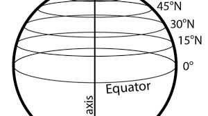
latitude
an imaginary line that runs parallel to the equator, measuring degrees north or south of it. (also known as a parallel)
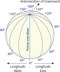
longitude
an imaginary line that runs north and south and measures distances east and west of the Prime Meridian
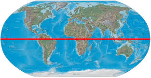
equator
the line of latitude that runs halfway between the North Pole and the South Pole (0 degrees latitude)
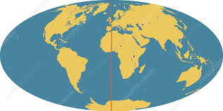
Prime Meridian
an imaginary line on the Earth that is used as the starting point for measuring distances east and west
continent
a large landmass on Earth
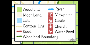
map key (legend)
a guide on a map that tells you what each symbol stands for
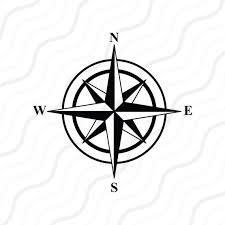
cardinal directions
north, south, east, west
compass rose
directional arrow that shows cardinal and or intermediate directions
insert map
a smaller map set within the border of a larger one
hemisphere
half the earth
degrees
units of latitude and longitude
coordinates
the latitude and longitude address of a place on a map (kind of like (X,Y) in math)
axis
an imaginary line that passes through the center of the Earth, halfway between the North and south Poles on which the Earth ROTATES
ocean
large body of salt water
climate map
shows information about the climate of an area. shows things like specific climatic zones of an area based on the temperature, amount of snow, or average of cloudy days. Use colors to show different climatic areas
Historical map
modern maps that show an event, place, or era from the past. These maps help us visualize locations and events from long ago. Shows multiple aspects of history: migrations patterns, ancient boundaries, political changes, etc.
Landform map (aka Physical Map)
shows the locations of landforms in a place. often use colors to show mountains, hills, plateaus, plains, and more. Also major bodies of water
landforms
natural physical features of the Earth's surface, including mountains, valleys, plateaus, and plains.
climate
the long-term average of weather conditions in a specific area, including temperature, humidity, and precipitation patterns.
population
the type of people and number of people who live in an area
culture
the beliefs, customs, arts, and social practices of a particular group of people.
economics
natural resources, agricultural products, income
temperatures are _____ at higher elevation
colder