Dawlish Warren Case Study
1/46
There's no tags or description
Looks like no tags are added yet.
Name | Mastery | Learn | Test | Matching | Spaced | Call with Kai |
|---|
No analytics yet
Send a link to your students to track their progress
47 Terms
What will happen to flood risk if the Dawlish warren is lost?
There is a higher flood risk for the the large populations behind the warren in Dawlish estimated at 2900 properties
What will happen to jobs if the Dawlish Warren is lost?
There is a golf course which will be lost decreasing jobs and the tourism provides jobs to the area so losing this will decrease economic prosperity
What will happen to local railway if Dawlish Warren is eroded?
50 towns/villages rely on the railway that passes through Dawlish to access London and the rest of the country
Such as the Penzance to London line with the section in Dawlish built by Brunel in 1846
This is highly vulnreable to flooding and losing the Dawlish warren will increase the risk of this flooding and being damaged
What will be the loss of ecosystems if the Dawlish Warren is eroded?
There will be a loss of internationally protected RAMSAR site for 23,000 wading birds
How has the Dawlish warren changed from 1945-Today?
In 1945 the spit was arround half the size it is today with no hook and defences were only present near the town of Dawlish
Compared to today the spit is longer but thinner with the distil end of the spit being highly hooked and recurved, there is a developed salt marsh formed behind the sheltered spit and there is groynes along the spit, a geotube and concrete beding placed across it
What does the ecosystem of Dawlish warren provide for animals?
Dawlish Warren nature reserve supports a huge diversity of species, many of which are nationally rare
It covers 214 hectares
Home to species like Sand lizards which is the UK’s rarest lizard and one of three native species
What are the different environmental recognitions Dawlish Warren has?
Site of Special Scientific interest
Special protection area
Special area for conservation
National nature reserve habitat NNR
Protected by the convention of wetlands (Ramsur)
How many tourists visit Dawlish warren each year?
480,000 people each year
In 2013-2014 how much sand was lost from the Southern face?
Around 5m
What coastal defence was used to protect the sand dunes and what has changed?
Around 1.2km of gabion baskets which were mostly removed in 2017 to allow dunes to follow their natural alignment.
A 450m long Geotube was buried within the dunes instead to support them and provide flood protection.
How many groynes have been implemented at Dawlish Warren?
17
What is the Dawlish Warren Beach Management Scheme?
The Teignbridge council proposed a range of works to allow the spit to exist
Using a hold the line scheme
This included beach nourishment using local sand, maintaining the sea wall at the western end to protect tourist facilities, replacing damaged groynes and removal of gabions to let dunes follow a natural alignment
Cost of £14 million to help the 3000 properties
What is an SMP?
A shoreline management plan which is a specific, technical document produced for a defined stretch of coastline
What is the shoreline management plan for Dawlish Warren?
Manage the spit of Dawlish Warren in a sustainable way, such that its function as a flood defence for the wider inner estuary is maintained
As well as creating new habitat in Exe estuary to provide compensation for habitat loss
The SMP position is hold the line at Dawlish Warren
What are the four possible SMP positions for a coastline?
Advance the line
Hold the line
Managed realignment
No active intervention
How do ICZM and SMP relate?
ICZM is the philosophy while SMP is the plan, where the SMP operationalises ICZM principles into actionable, costed policy decisions for specific coastal cells
What is an ICZM?
Integrated coastal zone management
What is integrated coastal zone management and what are the 3 main ideas of it?
A broad, strategic approach to managing the entire coastline in a coordinated way
Take a holistic long term view- balancing environmental, economic, social and cultural interests simultaneously
Involves multiple stakeholders such as local authorities, Environment Agency, Natural England, landowners and tourism business owners.
It aims to reduce conflict between competing uses e.g. tourism versus conservation tend to clash
What is the ICZM specific to Dawlish Warren?
At Dawlish Warren specifically, ICZM co-ordinates the tensions between protecting the National Nature Reserve habitat, maintaining the tourist economy and managing coastal erosion and flooding risk.
What is the plant species found exclusively at Dawlish Warren in the whole of the UK?
Sand crocus
What is the perceived long term benefit of the 2017 beach management scheme?
£158 million far exceeding the cost
This comes in the form of protecting the main railway line from storms and sheltering communities as nearly 2900 properties are protected
As well as ensuring the tourism industry providing millions annually does not decline
How big is the NNR at Dawlish Warren and what is it?
Dawlish Warren is classed as a national nature reserve
This spans 2km and 505 acres acting as a vital habitat for birds and lizards
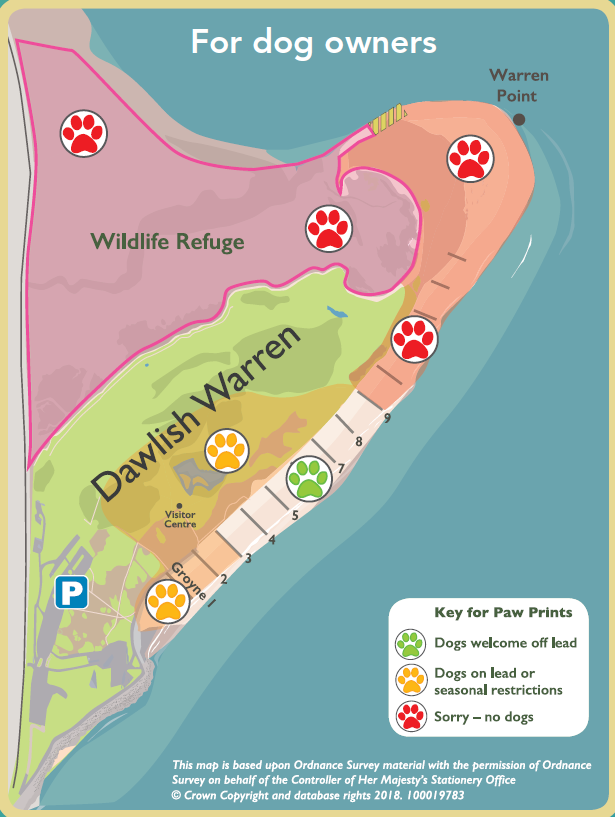
How has the ICZM philosophy been implemented with land management?
No dogs are allowed in the North Section of Dawlish Warren and at Warren Point to ensure the wildlife refuge for vital animals such as sand lizards and nesting birds are protected
The southern central zone of Dawlish Warren allows dogs on leads acts as a buffer zone allowing people to move from the car park to the beach
Meanwhile the narrow central spit near the south has been designated as a recreational area where dogs are allowed to ensure the stakeholders promoting tourism are also heard and zones for them are established
What has been the change in the shoreline management plan going forward and what does this mean in practice?
The SMP right now is hold the line but this will change to no active intervention in the future
This means no further beach nourishment or hard engineering investment
Allowing the spit to migrate and natural processes to occur
Accepting that the spit’s shape, position and extent will change over time
Why has the decision to change the SMP been made?
Change on the shite was greater than predicted following the 2017 scheme with the geotube now exposed and being a large failure
Hard structures were found to work against natural processes rather than with them
Climate change and sea level rise will make holding the line increasingly costly and ineffective as the spit can be eroded at higher points and faster rates
Also the role of the spit as a wave barrier for the Exe estuary may gradually diminish regardless of intervention due to changing climate.
With the new SMP plan what will happen with wildlife zones and existing defences?
Existing defences will be removed by 2050 such as the geotube, groynes and left over gabions
New wildlife zones are being provided near the Exe estuary in Devon to compensate for what has been lost.
Also all houses within 10km of a protected site must pay a contribution per dwelling into a central fund which pays for wildlife wardens patrolling the NRR, wildlife refuges, the zoning zones implemented and education campaigns.
How many visit Dawlish Warren annually?
Peak numbers in recent years reached numbers of around 850,000 visitors
What is the location of the Dawlish Warren?
South Devon at the mouth of the Exe estuary
What is the SMP called for Dawlish Warren?
The SMP (Sub-cell 8b)
What is a sub cell and what is the sub cell for Dawlish Warren?
A sub cells is the smaller section of land within a sediment cell that sediment is usually contained in
For Dawlish Warren the sub cell is from Langstone cliff and orocombe rocks where breakwater acts as a natural barrier for sediment
What is the issue with habitat replacement?
The law only requires compensation
It does not require exact like for like change of lost habitat meaning the value of the NRR at Dawlish Warren will likely not be recovered
What parties are involved with the ICZM at Dawlish Warren
The Environment Agency, Teignbridge district council, Natural England, Network Rail, Devon Wildlife Trust and the RSPB are all coordinated across the wider Exe estuary.
What shifted the Shoreline Management Plan and what does this suggest about sea level rise management?
The 2023 Post scheme review shifted the SMP from hold the line to no active intervention
This suggests the SMP has been largely unable to solve the issue of SMP and is buying time rather than solving the underlying threat
What is the limitation or catch with the change in the shoreline management plan and what does this highlight?
The change is not confirmed until the Exe Estuary Strategy Update in 2027
This means it may yet change and any changes in policy takes years to formalise and this highlights how bureaucracy and slowness in action can lead local government unable to actually manage rising sea levels which won’t wait
What is the coastal squeeze occuring at Dawlish Warren?
Rising sea levels combine with fixed hard defences to cause coastal squeeze
This is where saltmarsh and mudflat habitats are compressed between an advancing sea and immovable structures, becoming progressively smaller.
At Dawlish Warren, this threatens the internationally important intertidal habitats
What does the SMP pivot to No active intervention by 2050 show about SMP and ICZM?
It shows that ICZM and SMP are considerably more effective at managing the short term consequences of positive eustatic change
Whilst also conceding that in the long run these frameworks cannot hold back sea level rise indefinitely
However the impacts of these plans should be judged against the realistic impacts of mitigating the impacts of eustatic change as sustainably as possible not the impossible goal of preventing any impacts against the face of major climate change driven eustatic change
How old is Dawlish Warren?
A mere 7000 years old very young formed by post glacial sea level rises
What has been the change in the width of the Dawlish Warren over the past 250 years?
The Dawlish Warren spit has been reduced from around 250 m wide to only around 50m wide today over the past 250 years
What led to the formation of the spit and what maintains it?
Longshore drift in a northeasterly direction along the coastline
What is the prevailing wind and secondary wind at Dawlish Warren?
The prevailing wind originates from the South West which has led to longshore drift in a north easterly direction
Whilst the secondary winds come from the South East towards warren point which have contributed to the recurved spit head alongside wave refraction
Where is the geotube located?
At Warren point located at the end of the spit
What is flocculation?
When small, negatively charged clay particles suspended in freshwater meet saltwater and clump together due to chemical attraction as the salt causes the clay particles to lose their negative charge and instead stick together
How does flocculation play a role at the Dawlish Warren?
The sheltered low energy environment behind the spit allows floc which is clay particles clumped together due to flocculation to settle
These settle on the mudflats and saltmarsh behind the Warren and contribute to the development of these
What is the role of flocculation in forming salt marshes describe the transition steps?
Firstly fine sediment carried in the suspension by the Exe meets saline water and flocculation occurs
These flocs settle on the mudflat at low energy
Mudflats build up and pioneer species like cord grass colonise the area trapping more sediment
Organic matter accumulates and saltmarsh develops through halosere succession
Surface level gradually rises as more sediment is trapped by sediment
What also contributes sediment and deposits at the Dawlish Warren? (waves)
Constructive waves deposit sediment from the pole sands
These are sand banks in the sea which act as a source and were largely developed by a storm eroding dunes at Exmouth
What are the 4 main processes eroding the Dawlish Warren?
Wave action- the dominant process which occurs at the the distal end of the spit at Warren point which is the most exposed part of the landform facing open water with no shelter. What occurs is hydraulic action compresses air into any weaknesses in the unconsolidated spit. while abrasion from the suspended sediment grinds away at the tip and wave refraction occurs at the tip these have caused the distal end of the spit to rapidly erode and almost become an isolated island.
Tidal scour- Strong tidal currents up to 3m/s during spring tides actively remove sediment from the spit, particularly on the sturary-facing side at the mouth of the Exe.
Storm wave erosion- high energy southwesterly storms rapidly strip large volumes of sand from the seaward face of the spit
Aeolian processes- Onshore winds remove dry sand from the spit surface, which can result in net sediment loss from the spit if that sand is carried inland beyond the dune system