Earth Systems Lecture 21
1/11
There's no tags or description
Looks like no tags are added yet.
Name | Mastery | Learn | Test | Matching | Spaced |
|---|
No study sessions yet.
12 Terms
Air Masses around UK
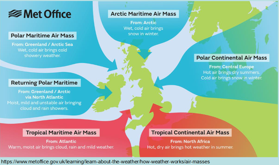
• Six airmasses affect the British Isles...
• Most common are Tropical Maritime (southwesterly flow) and Returning / Polar-Maritime (west or northwesterly flow)
Atmospheric Pressure in the Northern Hemisphere
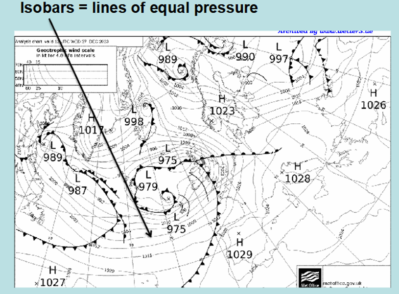
The atmospheric pressure is the pressure of the Earth’s atmosphere being exerted on a given location at the Earth’s surface.
Sea-level pressure is a standardised pressure, corrected for sea-level, so that we can compare atmospheric pressure regions.
Reminder from a previous lecture: Pressure Gradient Force and Coriolis Force play a big role movement of air through the Earth’s atmosphere
Average surface pressure is 1013 hPa
Opposite direction in southern hemisphere
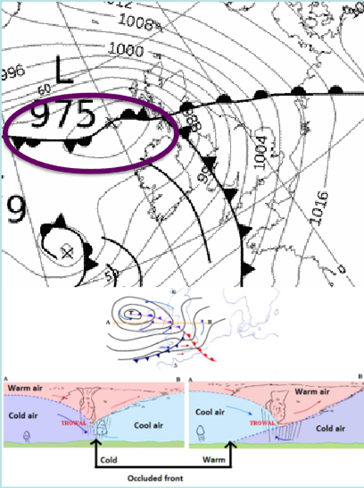
A Synoptic Weather CHart
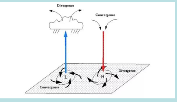
High pressure/anti-cyclone
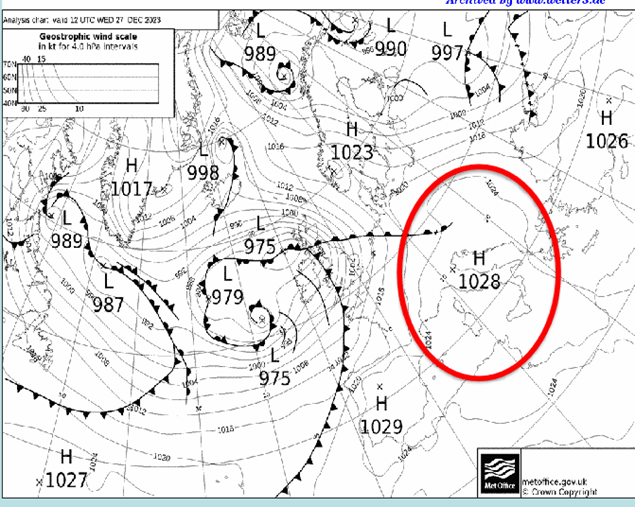
• High pressure, sometimes called an anti-cyclone is an atmospheric pressure distribution in which there is a high central pressure relative to the surroundings. It is
characterised on a synoptic weather chart by a system of closed isobars, generally approximately circular or oval in form, enclosing the central high pressure.
• Typically delivers a large area of stagnant weather conditions, which are often dry and settled (brought on by descending air drying from the mid-levels)
Low pressure/mid-latiture cyclones
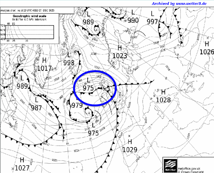
• Within an area of low pressure, air is generally rising vertically through the atmosphere. As it rises and cools, water vapour condenses to form clouds and can often times lead to precipitation.
• Consequently, the weather within an area of low pressure is often cloudy, wet and windy (with winds blowing in an anticlockwise direction around the depression in the Northern Hemisphere).
• There are usually frontal systems associated with depressions.
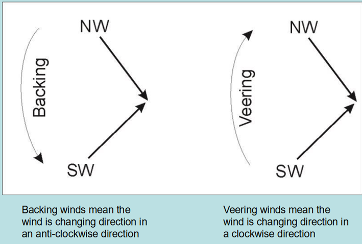
Wind change terminology: Backing and Veering Winds
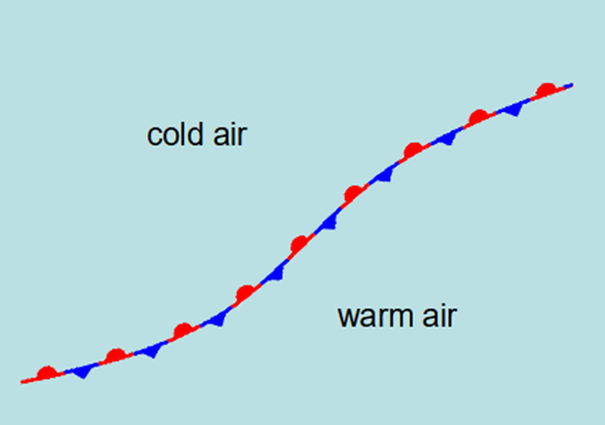
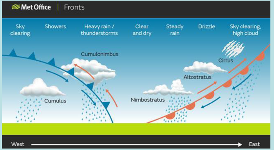
Cold Fronts Typical Weather Conditions
• A band of rain just ahead and along the cold front
• A sharp wind veer is common, southerly winds will veer northwesterly as the front
moves through the area
• Colder and drier conditions will follow as the front passes.
• In Britain showers can follow hours later
Warm Fronts Typical Weather Conditions
• Cool with increasing cloud (lowering in height as it approaches) with some periods of usually light rain ahead of the front.
• Winds often “back” from an easterly to southerly direction as the front moves through (N Hemisphere)
• Warmer, more humid air in place after it passes
• The area between the warm front and cold front is known as the warm sector
Occluded Fronts Typical Weather
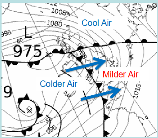
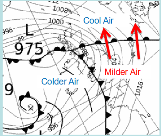
• Cold air is more dense, and thus moves faster into the milder air. This means a cold front as it circulates an area of low pressure will move faster than the warm front and “catch up” to the warm front, this produces what is known as an occluded front.
• Common conditions are cloudy, unsettled weather around the occlusion with a mixture of rain and showers
Stationary Front Typical Weather
• A front that is not advancing into a different airmass, at this stage it’s simply a boundary separating different airmasses
Cross-Section View of Weather Fronts
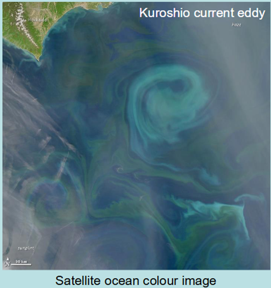
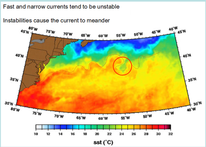
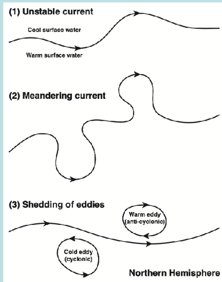
In the Ocean - Meanders and Eddies
Eddies are the ocean’s “weather”
– Longer lasting than atmospheric weather systems (months to years)
– Smaller radius (10s to 100s of km)
– May circulate cyclonically or anti-cyclonically
– Formed by “pinching off” of loops as a current meanders
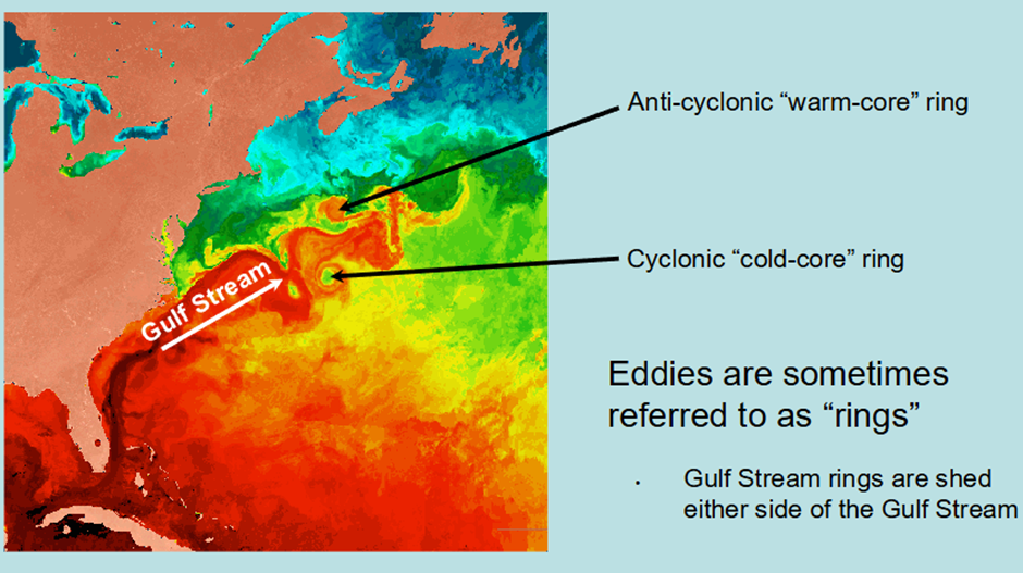
Gulf Stream Rings
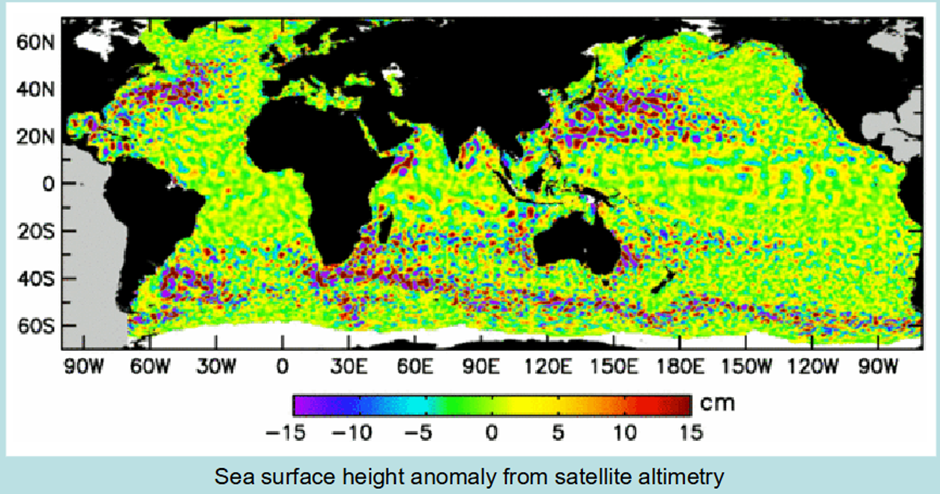
Global Eddie Variety
Why are eddies important?
• Eddies contain a different water mass (i.e., temperature and salinity) to the surrounding water
• Hence, they are a mechanism for the horizontal transport of heat and salt between water masses → eddy mixing
• They also may contain different nutrients and plankton species to the surrounding water → phytoplankton blooms
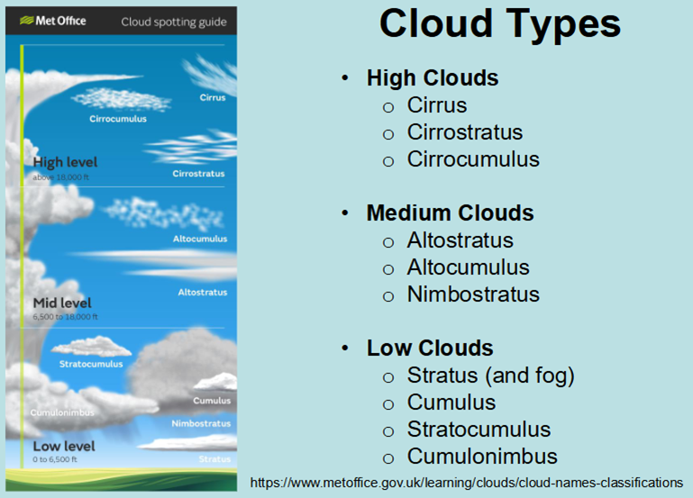
Cloud Types
Types of Fog
Radiation Fog
• Radiation fog usually occurs in the winter, aided by clear skies and calm conditions. The cooling of land overnight by thermal radiation cools the air close to the surface. This
reduces the ability of the air to hold moisture, allowing condensation and fog to occur. Radiation fogs usually dissipate soon after sunrise as the ground warms. An exception
to this can be in high elevation areas where the sun has little influence in heating the surface.
Advection Fog
• Advection fog occurs when moist air passes over a cool surface and is cooled. A common example of this is when a warm front passes over an area with snow cover. It is
also common at sea when moist tropical air moves over cooler waters. If the wind blows in the right direction then sea fog can become transported over coastal land areas.
Evaporation / Steam Fog
• Evaporation fog is caused by cold air passing over warmer water or moist land. It often causes freezing fog, or sometimes Types of frost. When some of the relatively warm water evaporates into low air layers, it warms the air causing it to rise and mix with the cooler air that has passed over the surface. The warm, moist air cools as it mixes with
the colder air, allowing condensation and fog to occur.
• Evaporation fog can be one of the most localised forms of fog. It can happen when:
• Cold air moves over heated outdoor swimming pools or hot tubs, where steam fog easily forms.
• Cold fronts or cool air masses move over warm seas. This often occurs in autumn when sea temperatures are still relatively warm after the summer, but the air is already starting to cool.
Valley Fog
• Valley fog forms where cold dense air settles into the lower parts of a valley condensing and forming fog. It is often the result of a temperature inversion with warmer air passing above the valley. Valley fog is confined by local topography and can
last for several days in calm conditions during the winter.