SSC Exam 3
1/82
There's no tags or description
Looks like no tags are added yet.
Name | Mastery | Learn | Test | Matching | Spaced | Call with Kai |
|---|
No analytics yet
Send a link to your students to track their progress
83 Terms
Cohesion
the attraction of water molecules for each other primarily due to hydrogen bonding.
Adhesion
the attraction of water molecules for solid surfaces. Water adsorption to the surface of soil via H-bonding.
Surface Tension
when water molecules have a greater attraction for each other than the air above, this creates the water-air interface.
Capillarity
the movement of water up a wick made of hydrophilic solid materials.
Gravitational Water Protential
Pulls water down.
Positive (i.e., work can be done by the water)
Matric Water Potential
Results from cohesion and adhesion
Negative potential (i.e., work must be done to extract the water).
Affected by differences in adhesion
related to pore size distribution.
Normally has the greatest effect on release of water from soil to plants.
As soil dries, matric potential decreases from zero (saturated) to a more negative number.
Osmotic Water Potential
Soil solution is a mixture of water and dissolved solutes such as:
Inorganic salts
Organic compounds
The greater the concentration of solutes the more negative is the water potential (energy is required).
Water moves toward the higher concentration to reach an equilibrium concentration.
Important for water entering roots.
Wilting point
water is held tight as a thin "film" surrounding soil particles… Adhesive forces are far greater than gravity.
Field Capacity
the amount of water a soil can hold against the pull of gravity. Where gravitational water stops draining.
Saturation
Macro, meso and micro-pores are filled with water. Oxygen is limited and the soil becomes anaerobic.
Gravitational Water
water that will drain freely due to gravity.
water between saturation and field capacity
The water is held in the macropores and not available for plants to use.
Plant Available Water
Water that the soil will relinquish to the plant.
Water between field capacity and permanent wilting point
The water is held in the mesopores
Unavailable Water
Water between permanent wilting point and oven dry
The water is held in the micropores and unavailable for plants to use
Evaporation (Hydraulic Cycle)
Radiant energy from the sun heats water.
Vapor is formed when water molecules become “excited” and transform from liquid phase to a gas phase.
Transpiration (Hydraulic Cycle)
Plants take in water through the roots and release it through the leaves.
Evapotranspiration (Hydraulic Cycle)
the cumulative loss of vapor to the atmosphere from evaporation and transpiration.
Runoff (Hydraulic Cycle)
Precipitation that reaches the surface of the Earth and ponds or flows over the surface
Infiltration (Hydraulic Cycle)
Portion of the precipitation that reaches the Earth's surface seeps into the ground.
How do infiltration rates vary?
Slope
Amount and type of vegetation
Whether the soil is already saturated by water
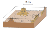
Soil Erosion Steps
Detachment
Transport
Deposition
Detachment (Erosion)
individual particles are loosened from the soil mass (rain splash, flowing water, wind).
Transport (Erosion)
Water or wind carries the detached particles downslope or downwind.
Soils need to be saturated before runoff can occur.
Once rainfall exceeds soil infiltration, water begins to flow overland.
Clayey soil tend to have more runoff.
Sandy soils tend to have less runoff.
Deposition
Detached particles are deposited in places of a lower elevation
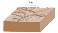
Sheet erosion
Uniform erosion from the entire soil surface following detachment due to raindrops.
Particles transported by shallow sheet flow and delivered to rill channels, leading to soil loss.
Rill Erosion
The removal of soil by concentrated water running through little streamlets. Rills can be repaired by tillage or minimal land leveling.
Typically form in different locations from year to year
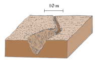
Rills develop and deepen downslope:
Water flowing in rills expands erosion.
Head cutting moves upslope.
Significant sediment transport.
Gully Erosion
Channels deeper than 18 inches that cannot be erased by cultivation or simple land leveling.
Looks more catastrophic and is locally destructive.
Most soil is lost by sheet and rill erosion.
“R” in the Revised Universal Loss Equation (RUSLE)
rainfall and runoff factor
“K” in the Revised Universal Loss Equation (RUSLE)
soil erodibility factor
“LS” in the Revised Universal Loss Equation (RUSLE)
slope and length factor of area
“C” in the Revised Universal Loss Equation (RUSLE)
cover/vegetation and management factor
“P” in the Revised Universal Loss Equation (RUSLE)
practices put in place to prevent erosion
What particle size is most easily eroded from soil?
Silt
Diagnostic Horizon
a layer or soil zone whose properties meet certain criteria specified for the purposes of classification.
A diagnostic horizon may be comprised of one or more of the genetic (A, E, B, C, etc) horizons.
Epipedons
what we call surface diagnostic horizons. Horizon that forms at or near the surface but is not the same as an A- horizon.
Subsurface diagnostic horizons
Horizon that forms below the surface. Can include one or more genetic horizons.
Mollic Epipedons
A thick, dark, colored mineral horizon (generally > 25 cm) at the surface.
The percent base saturation is greater than 50%.
Base saturation - the concentration of base cations (Ca, Mg, & K) divided by all cations (Ca, Mg, K, Al, H , etc.).
Characteristic of soils developed under native prairies.
Umbric Epipedons
Same characteristics as the Mollic except the percent base saturation is less than 50% due to leaching of basic cations (Ca, Mg & K).
The umbric develops in areas with higher rainfall than the mollic.
Melanic Epipedons
Soils developed from volcanic ash.
Mineral horizon that is very black in color due to its high organic matter content.
Bulk density is very low.
Organic Epipedons
Histic – A layer of organic soil that is naturally saturated with water.
Folistic – Like the histic except it is not saturated with water for more than 30 days. Tends to form in colder environments.
Orchric Epipedons
Fails to meet the definitions for any of the other epipedons.
Too light
Too thin
Too low in organic matter
If a soil's epipedon does not meet any of the criteria for the other epipedons, then it is ochric.
Argillic Horizon
A horizon that accumulates clay that has translocated from above.
The Bt horizon identifies the argillic horizon.
Natric Horizon
Like the argillic with the addition that sodium has accumulated and where there is > 15 % exchangeable sodium.
The horizon will also have columnar soil structure.
Kandic Horizon
An accumulation of Fe and Al oxides and kaolinite clays.
Low cation exchange capacities.
Form in areas of intense weathering.
Oxic Horizon
Highly weathered, very high in Fe and Al oxides.
Only has 10% weatherable minerals in the sand, silt or clay sizes, as compared to other soils which have weatherable minerals in the 50 to 90% range.
found mostly in humid tropical and subtropical regions.
Spodic Horizon
An illuvial horizon characterized by the accumulation of colloidal organic matter, aluminum oxide and iron.
It is commonly found in highly leached forest soils of cool humid climate, on sandy parent materials.
The Bh horizon identifies the spodic horizon.
Albic Horizon
A light colored eluvial horizon that is low in clay and other oxides which have been removed by leaching.
Often the E-horizon.
The color of the horizon is often white or light tan.
Calcic Horizon
An illuvial accumulation of carbonates (mostly CaCO3).
The carbonates will react with HCl giving off CO2 or bubbles.
Cambic Horizon
A slightly altered layer that has not undergone enough illuviation to become argillic.
The Bw horizon identifies this horizon.
Soil orders
Fine-loamy Mixed, Superactive, Mesic Aquic Argiudolls
= Mollisols
Soil Suborders
Grouped by similarities in soil formation such as wetter/dryer soil, colder/warmer soil, etc.
Our Example:
Fine-loamy Mixed, Superactive, Mesic Aquic Argiudolls
Suborder = Udolls
Formative element: Ud
A characterization of moisture regime
Ud = humid climates
Soil Great Group
Based on differences between soil horizons.
Our Example:
Fine-loamy Mixed, Superactive,
Mesic Aquic Argiudolls
Formative element: Argi
Presence of a specific diagnostic horizon
Argi = Argillic or Bt horizon
Soil Subgroup
Describes a profile characteristic, wetness, sand, etc.
Always the second to last word (and only one word).
Our Example:
Fine-loamy Mixed, Superactive, Mesic Aquic Argiudolls
Subgroup = Aquic Argiudolls
Formative element: Aquic
Aquic = Wet
Soil Family
Based on soil properties that affect management and root penetration, such as texture, temperature, clay minerals, cation exchange capacity, and depth.
One or more words separated by a comma.
Our Example:
Fine-loamy Mixed, Superactive, Mesic Aquic Argiudolls
= Fine-loamy Mixed, Superactive, Mesic
Soil Series
Named from the town or landscape feature near where the soil was first recognized
Examples:
Norfolk
Lynchburg
Goldsboro
Pantego
Irrigation
applying controlled amounts of water to land to help plant growth
Macropores
Large pores, water drains rapidly through them due to the force of gravity. Difference between saturation and field capacity.
Micropores
Small pores, tend to retain water so tightly, its unavailable to plants. Think about capillary action! Difference between wilting point and oven dry.
Mesopores
Medium-sized pores, is the pore space where you will find plant-available water. Held tighter than the force of gravity but not so tight that plants can’t extract the water. Difference between field capacity and wilting point.
Gypsum blocks
The resistance of electrodes embedded in a porous block is proportional to its water content.
Tensiometers
Measuring the tension of water due to adhesive forces with soil solids
Time domain reflectometry (TDR)
Using radar to transmit signals into soil and analyzing the reflected signals
Gelisols
frozen
Histosols
Organic soils rich in decomposed plant material, typically found in wetlands.
Spodosols
Organic matter has eluviated from the topsoil & accumulated in the subsoil zone of illuviation
Strong E Horizon (Bh)
Andisols
Recent volcanic ash deposits and subjected to only mild weathering.
Oxisols
Highly weathered tropical soil Low Cation exchange capacity
Vertisols
Large accumulations of shrink swell clay
Aridisols
Soil typical of deserts and dry
Ultisols
Highly weathered soils, fertile in humid regions,
Base Saturation <35%
Mollisols
Soils w/ thick, dark surface horizons typically in prairies.
Alfisols
Argillic fertile soil, found in subtropical forest
Base saturation >35%
Inceptisols
young, weakly developed B horizon
Entisols
young age minimal soil horizon development
No B horizon
Mollic
Thick dark rich >50% BS
Udic
Moist
Aquic
Saturated
Umbric
Dark <50% BS
Argillic
Clay accumulation
Kandic
Low activity clay
Xeric
Mediterranean
Cambic
Weak B horizon
Folistic
Unsaturated for 30 days
Histic
Organic saturated