Geological maps
1/81
There's no tags or description
Looks like no tags are added yet.
Name | Mastery | Learn | Test | Matching | Spaced | Call with Kai |
|---|
No study sessions yet.
82 Terms
What are the main stratigraphic principles?
Original horizontality
Stratigrapgic superposition
Lateral continuity
Cross-cutting relationships
Define contact and deposition.
Contact: The boundary between 2 lithologies
Deposition: Material carried by fluid/gravity and settled on a substrate
What is emplacement?
Forcible intrusions or eruption of magma (subsurface) or lava (surface) or veins from hot fluids
What are thress measurements used for planar features?
Strike
Dip
Dip direction
Define dip
The steepest angle between an inclined planar feature and a horizontal plane - record as an angle
Define strike
The compass direction of the intersection between a dipping plane and a horizontal plane. - recorded as a three-digit (000)
How is dip direction related to strike?
Dip direction is always 90 degrees from strike. [ Use the left-hand rule: index finger points along strike, thumb points in dip direction.]
Name examples of geological features which can have strike and dip measurements.
Bedding
Faults
Cleavage
unconformities
fold axial planes
lithological contacts
metamorphic fabrics
What is the difference between true dip and apparent dip?
true dip is always perpendicular to strike whereas apparent dip is based on the perspective/viewing direction
What is the Rule of V’s?
A tool to work out dip direction using maps. A planar feature intersecting a valley will make a V shape pointing in the direction it is dipping.
What determines outcrop patterns?
Defined by geology interacting with topography
predictable once you measure planar features
steeper features make less exaggerated patterns
shallower features make more exaggerated outcrop patterns
What is deformation and what does it tell us?
The change in shape, size, or position of an object resulting from an applied force
Allows us to interpret the structural history and the deformation conditions
What is rheology?
The study of material responses to deformation. Environmental conditions like pressure, temperature, and fluids partially govern rheology.
What is stress and what are its units?
Stress = Force / Area
Units include:
Pascal (Pa) N/m2
MegaPascal (MPa)
100MPa = 1kbar
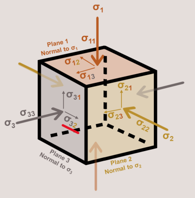
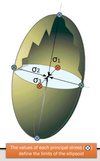
What are the three principle stresses?
σ1 = Maximum principal stress (compressive/squashing axis)
σ2 = Intermediate principal stress
σ3 = Minimum principal stress (extensional/stretching axis)
Define different types of stress
Mean stress: Average of principal stresses
Differential stress: σ1 - σ3 (difference between the max and min principal stresses
Deviatoric stress: represents `distortion/ deformation relative to mean stress
Total stress: σ1 + σ2 + σ3 (combination of volume and shape changes)
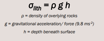
What is lithostatic stress?
Mean stress equivalent
Gives estimate for stress/pressure at given depth
Does not account for anisotropic nature of stress
lithostatic stress = p g h
What is hydrostatic stress?
Pressure exerted by fluid contained within geological formations
Isotropic like lithostatic
hydrostatic stress = pgh
What happens with pore-fluid pressure/overpressure?
Fluids get trapped in rock pore space become pressurised
Can lead to hydrofracturing
Results in: mineral vein formation, earthquakes and fracking
How does differential stress operate on tectonics?
Slab pull and ridge push mechanism
governed by density difference
graviational push of cooling oceanic crust with age as it moves from MOR
Cold, dense ocean crust sinks into mantle at sunduction zone
What are the three main tectonic stress regimes?
Vertical σ1 (maximum):
Vertical compression - gravity and/or upwelling mantle
Results in normal/extensional fault systems
Creates extensional basins
Vertical σ3: minimum principle stress
Horizontal compression
Creates folds and thrust belts
Forms mountain belts and plateaux
Vertical σ2:
Both compression and extension are parallel to Earth’s surface
Results in strike-slip regimes and shows translation of geological markers obvious in map view
Development of strike-slip fault systems
What is strain?
Size or shape changes to an object in response to deformation
Differs from rigid body deformation (rotation/translation without changing volume/shape)
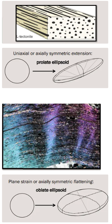
What are the two main types of rock fabrics?
L.tectonites
Linear tectonic fabric
Looks like a fistful of pencils
Examples: amphibolite fabrics, stretch pebbles
S-tectonites
Planar tectonic fabrics
Sheet-like
Examples: mica-defined/gneissose banding
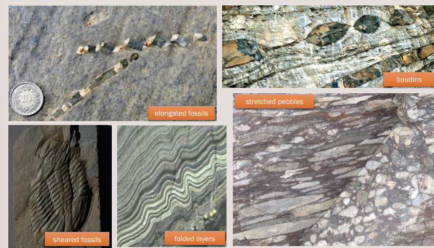
Measuring strain in 1D
Linear strain causes a change in length or geological materials
extension/contraction
the change in length of a stretched object e.g fossil in a fault or shear zone
Measuring strain in 2D
Shear strain causes change in shape or orientation of geological materials
If the initial shape of the object is know → we can measure the angular rotation between known linear strain markers
particularly in fossils
Can also measure the x, y and z dimensions 2-D and possible 3D strain
Assume it they are perfect spheres → not real life
What is fold anatomy?
Form where initially planar features become curved/bent
Consists of hinge flanked by two limbs
Hinge point = point of maximum curvature
Hinge zone = volume of high curvature material around hinge point
Hinges extrapolated along hinge lines
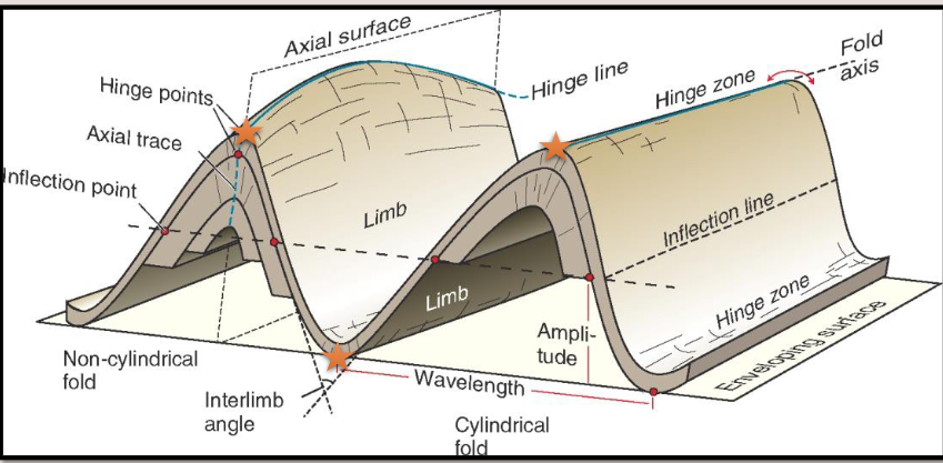
What’s the difference between cylindrical and non-cylindrical folds?
Cyclindrical folds: hinge projects as straight (like a toilet roll)
Non-cylindrical folds: hinge projects as curved line (can indicate redeformation or dome/basin structure)
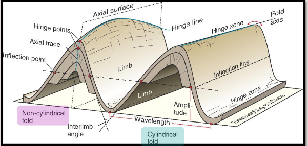
Define fold wavelength and amplitude
Wavelength: measured between two hinges
Amplitude: measured between hinge and inflections
What is an axial plane/surface? Starred
Connects the hinge lines of multiple folded layers
Can be measure as a planar feature (strike/dip/dipdirection)
Creates axial trace where it intersects Earth’s surface
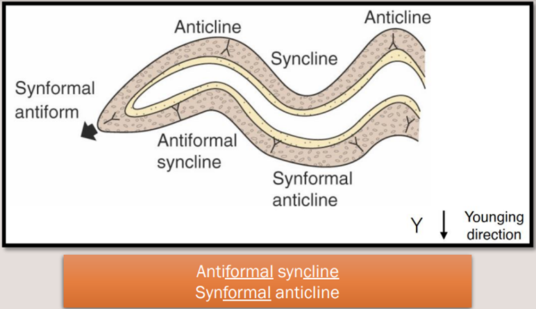
Explain the difference between -forms and -clines
Antiform : oppositely dipping limbs
Synform: limbs dipping towards eachother
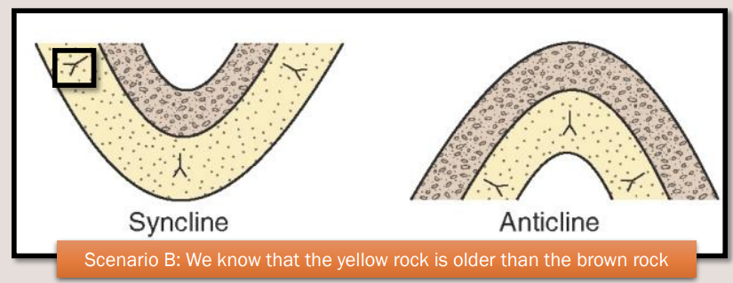
Anticline: oldest rocks in core, younging outward
Syncline: rocks in core, younging inward
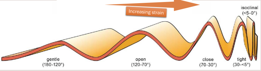
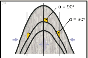
What determines fold tightness?
Determined by size of interlimb angle
Qualitative way of determing how much strain a folded layer has experienced (Arms out and being pushed inwards → the more strain on your arms the smaller the angle would be.)
Interlimb angle can measured with protractor or compass clino
Isoclinal folds: both limbs orientated parallel
What are some descrptive terms for the curvature of a fold
Low radius of curvature = sharp fold
High radius of curvature = rounded fold
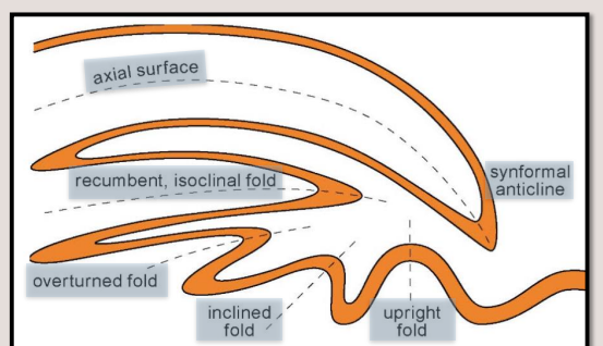
How is the orientation of a fold classified?
Classified based on the inclination of the hinge line
an uptight fold has a vertical axial surface
Inclined folds have inclined axial surfaces
Increased inclination can lead to one limb becoming overturned as the axial surface becomes flatter
A flat axial surface = a recumbent fold
Rotation of the axial surface >90o from upright produces an inverted fold (synformal anticline, antiformal syncline)
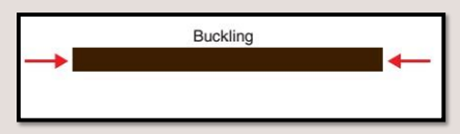
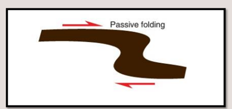
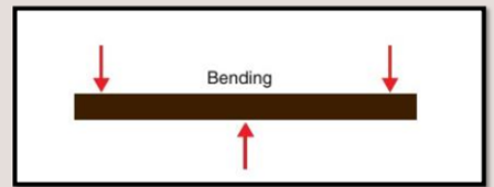
What are the three main folding mechanisms?
Buckling: active folding by forces acting parallel to layers of different competency (squash it on its side
Passive folding: layers of comparable competency are passively sheared (when in lower crust and it is hot and sticky the layers will flow passively due to the stress)
Bending/Flexure: Warping of layers in response to orthogonal stress (salt or magmatic loading)
What are the controls of buckling?
Viscosity/ competency contrast between the layer and the surrounding layers
Layer thickness - thicker layers produce folds with longer wavelengths
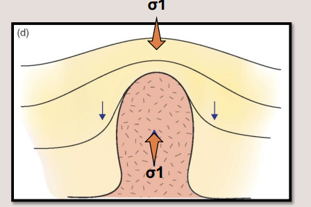
What causes bending/flexure?
Monoclinal fold forming during rifting
can occur in settings where you may have a buried fault beneath some ductile layers
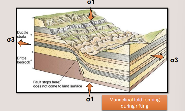
Salt or magmatic loading
the crust can be loaded by putting a big suite of magma.salt dome and cause the layers to flex around it
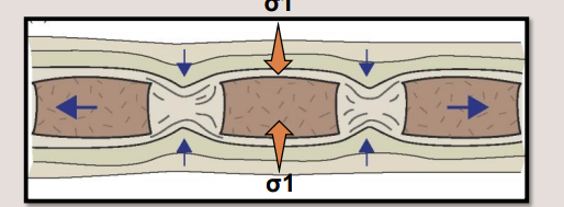
Boundinage
One less competent unit bends into a broken more competent unit
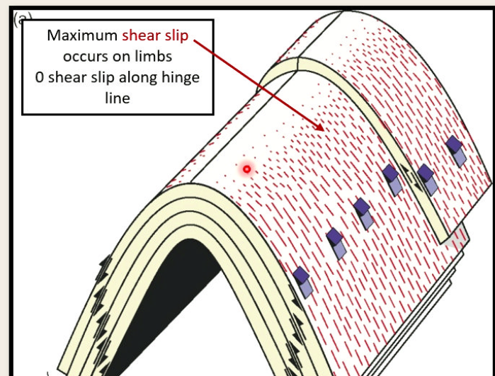
What are the three main mechanism of flexure?
Flexural slip
like bending book pages
Frictional sliding at layer interfaces
Low-temperature at layer interfaces
Low-temperature conditions
Shows striations on bedding surfaces
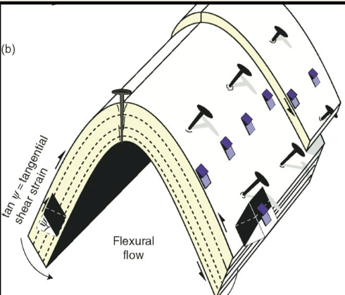
Flexural flow
Internal ductile deformation within layers
May occur at high temperatures
Common in weaker materials (mudstones )
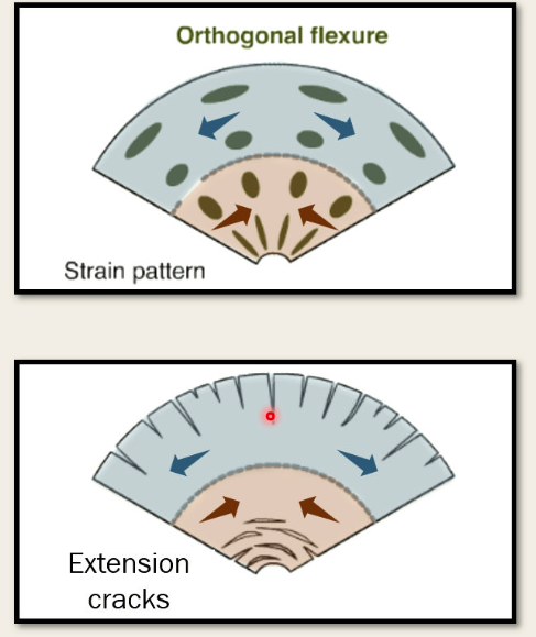
Orthogonal flexure
How the fold, folds at the hinge
Causes tension in outer arc
causes compression in the inner arc
What are parasitic folds?
Form when thin layers buckle earlier than thick layers
Become asymmetric on fold limbs (Habe a long limb and a short limb)
Long limb lean toward hinges of larger structures
Form predictable S,Z and M- fold patterns
What is cleavge and how does it form?
Rock cleavage is penetrative foliation governed by minerals with themselves have a strong cleavage
Is is a strain fabric produced during deformation
Can form where minerals align under tectonic stress
Cleavage = low grade metamorphism
What is crenulation cleavage?
Forms when original cleavages are deformed by later events
Creates crepe-like paper texture
common in metamorphosed mudstones
Shows folding/crinkling of initial cleavage
How does cleavage help predict fold structure?
If cleavage forms at the same time with fold → the cleavage will form parallel to axial planes
If the cleavage is axial planar, you can measure the angle between the bedding and the cleavage to find where you on the fold
fold hinge = 90 degrees
fold limb: <90 degrees
What shows the true geometry of a fold?
Only a profiles taken 90 to the hinge line/axial plane (only cross ections parallel to the true profile)
How do upright vs plunging folds appear on maps?
Upright folds show barcode/traintrack patterns
PLunging folds show fold closures:
Antiforms close down-plunge
Synforms open down-plunge
How can you identify folds on maps when closures aren’t visible?
You can identify folds through:
Reflected stratigraphy - mirrors of the same strata)
Reversal of younging direction across fold axes
Reversal of dip markers - but not reliable for overturned folds
How do structure contours appear in folded rocks?
They are parallel on the limbs for upright folds with horizontal axes.
They increase elevation towards antiform hinge
They decrease in elevation towards synform hinge
Spacing varies due to dip direction:
Wider spacing in hinge
Narrower spacing on limbs

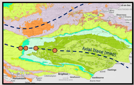
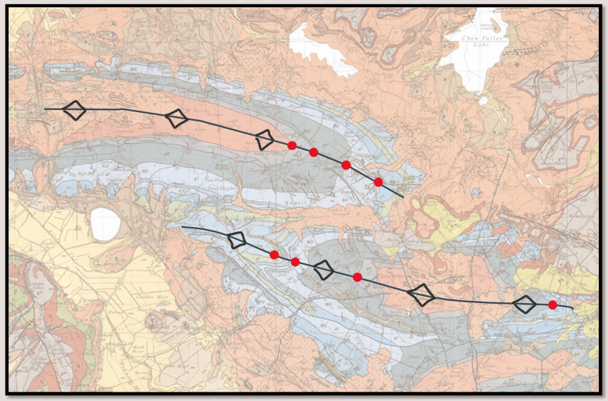
How are fold axial traces shown on maps?
Axial traces connect hinge points
Antiforms: chevrons pointing away from axial trace (not coloured in)
Synforms: chevrons pointing toward axial trace
Anticlines/Synclines: same as above but coloured in
Arrows indicate plunge direction
Two opposite arrows indicate a dome
What is vergence and how is it shown?
Vergence shows the way a fold leans and it will affect the spacing of structure contours on each limb
Shown with a single chevron indicating lean direction
Affects structure contour spacing:
steep limb = narrow structure contours
Shallow limbs = wide structures contours
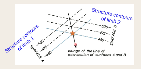
How can you determine fold hinges from structure contours?
Match up equivalent structure contours
The point where they meet = hinge points
Joining successive hinge points from other structure contour intersections = hingeline
This methos works for intersections of any two planr features.
How do you distinguish between topographic features and actual folds
If curvature of contact is associated with curvature of topographic contours, it’s likely a feature dipping into valley (not a fold).
If curvature of contacts occurs where topographic contours are not curved it indicates structural variation
What is elastic behaviour in rocks?
Rocks behave elastically in the upper crust, where deformation is fully recoverable until applied stress is relaxed to a point.
Important factors include:
strain rate
temperature,
cohesion/lithification of rock
What happens when rocks reach their yield point?
When rocks reach their yield point, they can’t appreciate any more strees and fracture in the brittle/frictional regime of the crust. This immediately relieves stress but causes irreversible damage to the rock
What are cracks and how does stress act on it?
They are 3D ellipsoids - not square or lines
Stress concentrates at the tip of a crack
The more elliptical, the more stress concentrates
What are the main types of fractures?
Mode i (extension fractures)
propagate along σ1 and σ2 axes
Open and widen along σ3 axis
Son’t show any sense of offset
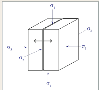
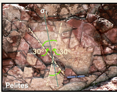
Mode ii (shear fractures)
Accommodate slip and offset geological markers
Form ~30 degrees from σ1
Can from conjgate pairs ( dipping in opposite directions
when shear fractures grow they create faults
What is a fault zone?
A tabulate volume of rock undergoing deformation with a localised slip zone
must have brittle or frictional deformation mechanisms, as ductile behaviour in mid-lower crust inhibits fracturing.
Define hanging wall and foot wall
Hanging wall: the block you would hang a lamp on
Footwall: the block you would stand your foot on
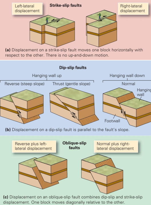
What are the three types of fault displacement?
Strike slip
Fault slip is parallel to the strike of the fault
Side-to-side motion across the fault
Dip slip
Fault slip is 90 degrees to the strike of the fault
Up-and-down motion across fault
opposite to strike slip
Oblique slip
a mixture of the two
Diagonal motion across fault
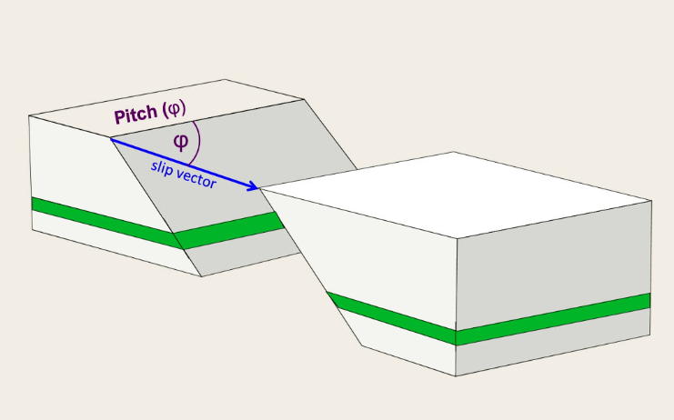
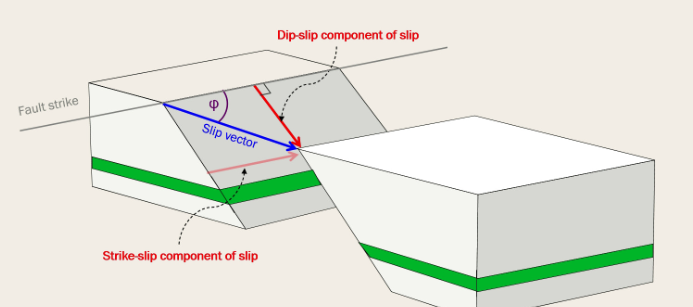
What is the slip vector and the pitch?
The slip vector represents the magnitude at which a fault has moved along a particular direction.
Only a cross-section parallel to the displacement vector will show true displacement of offset markers
Pitch is the angle between the fault strike and the slip vector
What are the main types of dip-slip faults?
Normal faults:
hanging wall downthroan relative to footwall
down-dip slip vector
Usually high angle (~60)
Accomodates stretching/extension
Reverse/thrust faults:
Hanging wall upthrown relative to footwall
Up-dip slip vector
Usually 45- 60 dip angle (thrust <30 - shallow)
Accomodates shortening/contraction
What are the types of strike-slip faults?
Sinistral (left-lateral):
Left-lateral displacement
Near-vertical dip
Accommodates translation
Dextral (Right-lateral):
Right-lateral displacement
Near-vertical dip
Accommodates translation
What is Andersonian faulting?
Stress configurations relative to Earth’s surface produce particular fault geometries
σ1 vertical: extensional regime, normal faulting
σ2 vertical: compressional regime, thrust faulting
σ3 vertical: translational regime, strike-slip faulting
What are slickensides, slickenlines and slickenfibres?
Slickensides: polishes fault surfaces resulting from abrasion/frictional wear
Slickenlines: grooves/lineations onslickensides indicating abrasion pathway of clast/minneral
can measure plunge and trend of slickenlines to approximate fault slip vector
Slickenfibres: during slips, gaps open along fault planes and develop fibrous textures
What are the main types of fault rocks and where do they form?
Brittle fault rocks (up to 10-15km depth)
Grain size is reduced by fracturing and frictional wear. incohesive or cohesive
Fault gouge or falt breccia
cataclasite
Pseudotachylite
Ductile fault rocks (>10-15km depth)
Mylonites - rocks deform plastically in shear zones
deformation achieved by diffusion of atoms
How do fault rocks form?
From physical damage, chemical alteration and fluid-rock interaction
What is a fault trace?
The intersection of a fault plane with the Earth’s surface
What is a fault scarp?
An exposed fault plane with marked relief change
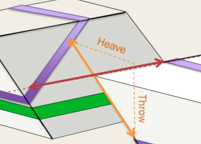
What’s the difference between slip and separation?
Slip: quantitative measurement of magnitude and direction of fault motion (slip vector has dip-slip and strike-slip components)
Separation: Displacement of a marker horizon along strike or up-down dip surface
What are heave and throw?
Heave: Horizontal component of dip separation
Throw: Vertical component of dip separation
How can fault mechanics be determined from mapping?
Map symbols
Offset of oppositely dipping markers
Fault dip direcction
Stratigraphic knowledge
What happens to stratigraphy around faults?
Faults can result in the repetition or omission of stratigraphy either down a borehole or in outcrop patterns
What are piercing points?
Sawn off, diplaced narkers which can be found located at either side of the fault (incredibly rare)
How does erosion affect fault identification?
Erosion often removes topographic evidence of fault scarps, leaving only patterns that show offset of geological markers
What effect do fault zones have on geomorphology?
Faulting physically and chemically damages and alter rocks
Fault zones are often easily eroded - greating gullies and valleys
Can cause vegetation changes by drainage
How can fault dip direction be determined?
Using the V-in-the-valley rule
Lookung at how exaggerated the outcrop pattern is
Constructing structure contours on a fault
What is the Law of Superpositions role in fault interpretation
Young rocks must come down to be in contact with older rocks
What are the characteristics of conformablesequences on maps?
Rock units initially deposited continuously
No erosion or time gaps
Right-way-up strata young in direction of dip
Geological contacts do not cross cut one another
Conformable layers are not repeated (unless faulted)
How can you recognise unconformable contacts?
An unconformity surface truncates or cuts into older geological features.
What are the characteristics of angular unconformities?
Demonstate change in orientation of strata across their interface
Visually striking in field and on maps
Signified by abrupt changes inn dip and/or strike of units
How do disconformities differ friom angular unconformities?
Disconformities are subtle features in the field and on maps
They represent a time gap or erosion in parallel rock units
Strike and dip values may be identical or very subtly different
Look for evidence of missing stratigraphy and major environmental changes across contacts
What is a flat planar unconformity?
produced by peneplanation
represents mature landscape with very low relief above sea level
Found in mature river courses and shallow marine settings
Shows evenly spaced, parallel structure contours
What are irregular unconformities?
REpresent buried landscape with preserved paleotopography (hills and valleys)
Sedimentary/volcanic rocks above may be highly variable in thickness and lithology
Common in alluvial and aeolian deposits
Difficult to structure contour
What is subcrop?
Defines the intersection of features beneath an unconformity with the unconformity surface
If both unconformity and subcrop features are planar - their intersection forms a line
Can be projected beneath unconformity to determine in subsurface
Pattern can be defined by joining intersection points if same elevation using structure contours