Tema 2 Econ Geo
1/17
Earn XP
Description and Tags
Earth Basics & Geometry
Name | Mastery | Learn | Test | Matching | Spaced | Call with Kai |
|---|
No analytics yet
Send a link to your students to track their progress
18 Terms
Key Earth Parameters
Equatorial Diameter: 12,757 km
Polar Diameter: 12,714 km (Earth is an oblate spheroid)
Equatorial Circumference: 40,077 km
Polar Circumference: 40,009 km
Axial Inclination: 23.5° (obliquity of the ecliptic)
The angle between Earth's equatorial plane and its orbital plane (ecliptic).
Consequence: Creates seasons and unequal distribution of solar radiation across latitudes.
Seven Principal Tectonic Plates
# | Plate |
|---|---|
1 | Antarctic Plate |
2 | Pacific Plate |
3 | South American Plate |
4 | North American Plate |
5 | African Plate |
6 | Eurasian Plate |
7 | Australian-Indian Plate |
Flashcard 2: Smaller Tectonic Plates
Region | Plates |
|---|---|
Mediterranean / Middle East | Hellenic-Turkish Plate, Iranian Plate, Arabian Plate |
Pacific / Americas | Juan de Fuca Plate, Caribbean Plate, Nazca Plate, Cocos Island Plate, Scotia Plate, Philippine Plate |
Main Volcanic Zones of the Earth (5 Zones)
(5 Zones)
Zone | Key Examples |
|---|---|
1. Pacific Ring of Fire | Most active zone; includes Kamchatka (Klyuchevskaya Sopka), Japan, Andes, Cascades |
2. Mid-Atlantic Ridge | Iceland, Azores; divergent plate boundary |
3. East African Rift Valley | Kilimanjaro, Nyiragongo; continental rift zone |
4. Mediterranean-Alpine Belt | Vesuvius, Etna, Santorini; collision zone |
5. Intraplate Hotspots | Hawaii (Mauna Loa), Yellowstone, Canary Islands |
Volcanic Zones – Recognition
Volcano | Location | Zone |
|---|---|---|
Klyuchevskaya Sopka | Kamchatka, Russia | Pacific Ring of Fire |
Mauna Loa | Hawaii, USA | Intraplate Hotspot |
Vesuvius / Etna | Italy | Mediterranean-Alpine Belt |
Eyjafjallajökull | Iceland | Mid-Atlantic Ridge |
Kilimanjaro | Tanzania | East African Rift |
Post-Volcanic Phenomena – Definitions
Type | Temperature | Characteristics |
|---|---|---|
Fumarola | ~200°C | Mineral-rich water vapor eruptions |
Solfatara | ~100–200°C | Water vapor containing hydrogen sulfide (H₂S) and sulfur dioxide (SO₂); sulfur deposits |
Mofetta | 0–100°C | Dry carbonic acid vapor (CO₂); no water vapor |
Geyser | Varies | Intermittent hot water eruptions; natural hot springs |
Atmospheric Layers – Order & Boundaries (Bottom to Top)
Layer | Altitude Range | Key Characteristics |
|---|---|---|
Troposphere | 0–16 km | Weather forms; contains 75% of atmosphere; temperature decreases with altitude; extends 8 km at poles, 16 km at equator; top temp: -75°C |
Stratosphere | 16–50 km | Ozone layer peaks at ~22 km; contains 20% of atmospheric molecules; temperature increases with altitude |
Mesosphere | 50–80 km | Meteors burn up ("shooting stars"); coldest layer (as low as -90°C at top) |
Thermosphere | 80–640 km | Temperature rises (up to 230°C); contains ionosphere (charged particles) & magnetosphere; Northern & Southern Lights occur here |
Exosphere | 640–64,000 km | Farthest layer; air dwindles to nothing; molecules drift into space |
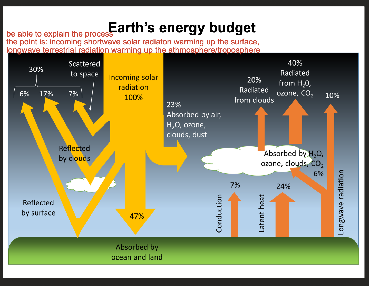
Earth's Energy Budget – Core Mechanism
Incoming: Shortwave solar radiation passes through atmosphere
Surface: Warms the Earth's surface
Outgoing: Surface emits longwave terrestrial radiation
Atmospheric Warming: Longwave radiation is absorbed by greenhouse gases (H₂O, CO₂, ozone) and clouds, warming the atmosphere/troposphere
Incoming Solar Radiation (100%)
Component | Percentage |
|---|---|
Reflected/Scattered to Space | 30% (total) |
└ Reflected by clouds | 17% |
└ Reflected/scattered by atmosphere | 7% |
└ Reflected by surface | 6% |
Absorbed | 70% (total) |
└ Absorbed by atmosphere (air, H₂O, ozone, clouds, dust) | 23% |
└ Absorbed by Earth's surface | 47% |
Longwave Radiation (Outgoing)
Component | Percentage |
|---|---|
Radiated from clouds | 20% |
Radiated from H₂O, ozone, CO₂ | 40% |
Latent heat (evaporation/condensation) | 24% |
Conduction (surface to air contact) | 7% |
Longwave radiation escaping to space | 6% |
Energy Budget – Summary
Incoming: 100% shortwave solar radiation
Reflected: 30% returned to space (albedo)
Absorbed: 70% warms Earth system
Atmospheric Warming: Primarily from absorbed longwave terrestrial radiation (greenhouse effect)
Key Insight: The atmosphere is heated from the ground up—surface absorbs shortwave radiation, then emits longwave radiation that greenhouse gases trap
Key Terminology for Earth's Energy Budget
Term | Definition |
|---|---|
Shortwave Radiation | Incoming solar radiation (visible light, UV) |
Longwave Radiation | Outgoing terrestrial radiation (infrared) |
Albedo | Reflectivity of a surface; Earth's average albedo is ~30% |
Greenhouse Effect | Trapping of longwave radiation by atmospheric gases (H₂O, CO₂, O₃) |
Latent Heat | Energy absorbed or released during phase changes (evaporation, condensation) |
Conduction | Direct heat transfer between surface and air |
Climate Zones Recognition
Zone | Latitude | Key Features |
|---|---|---|
Tropical | 0°–30° | High temperatures year-round; high precipitation (rainforest) or seasonal (savannah) |
Temperate | 30°–60° | Four distinct seasons; moderate temperatures; westerly winds dominate |
Polar | 60°–90° | Very cold; low precipitation; polar easterlies; permanent ice or tundra |
Arid vs. Humid Climate
Arid vs. Humid Climate
Type | Definition | Characteristics |
|---|---|---|
Arid Climate | Annual evaporation exceeds annual precipitation | Endorheic basins (no drainage to ocean); rivers lose water to evaporation or flow into impermeable lakes |
Humid Climate | Total precipitation exceeds maximum possible evaporation | Excess removed as surface runoff (rivers flow to ocean) |
Semi-Humid Climate | Evaporation exceeds precipitation for only a few months | Transitional between humid and arid |
Climate Definitions
Term | Definition |
|---|---|
Climate | Set of near-Earth atmospheric and weather processes affecting Earth's surface over a long period, specific to a place or region |
Climate Elements | Measurable atmospheric phenomena: solar radiation, pressure, humidity, temperature, wind, evaporation, precipitation, cloud cover |
Climate Factors | Surface features influencing climate: latitude, altitude, land cover, exposure |
Climate Zones | Zonal areas with typical climatic characteristics; shaped by irradiation patterns and wind cycles; closely linked to vegetation zones |
Climate Diagram
Definition: A simplified graphic representation of the most important climate elements (primarily temperature and precipitation)
Purpose: Primarily used to compare different climate types
Typical Format: Red line (temperature), blue bars (precipitation), months on x-axis
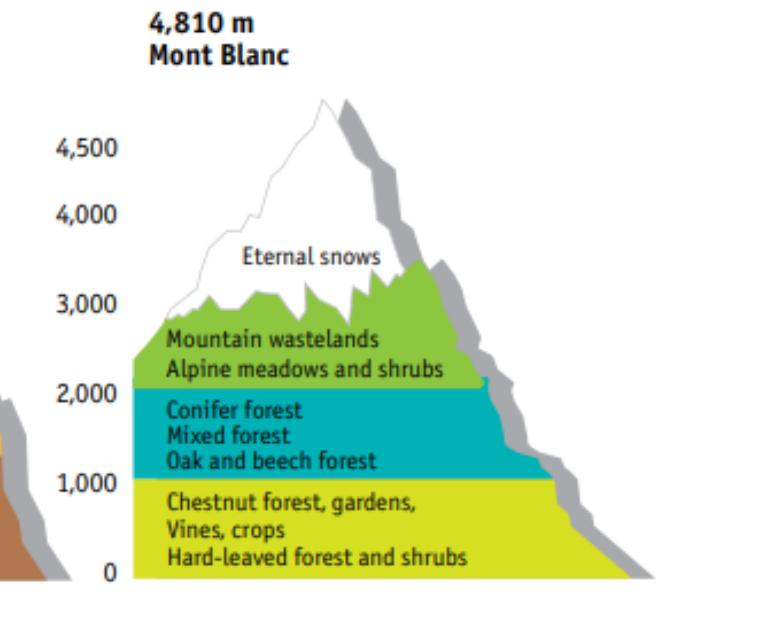
Altitudinal Zonation – Key Principle
Concept: As altitude increases, climate becomes colder and harsher, creating vegetation zones similar to those found at increasing latitudes (from tropical to polar)
Rate: Temperature drops approximately 6.5°C per 1,000 m elevation (lapse rate)
Alps (temperate zone): Shorter vertical sequence (base: temperate forest → top: snow)
Himalayas (tropical zone): Longer vertical sequence (base: tropical forest → top: snow)
Altitudinal Zones – Mont Blanc (Alps) – From Bottom to Top
Altitude Zone | Vegetation |
|---|---|
Lowest (foothills) | Hard-leaved forest and shrubs (Mediterranean influence) |
Chestnut forest, gardens, vines, crops | |
Oak and beech forest | |
Mixed forest | |
Mid-altitude | Conifer forest |
High altitude | Alpine meadows and shrubs |
Mountain wastelands | |
Highest | Eternal snows |
Atmospheric Circulation – Key Pressure Zones
Zone | Pressure | Air Movement |
|---|---|---|
Equator (0°) | Low | Rising air (convergence) |
Subtropics (~30°) | High | Descending air (divergence) |
Subpolar (~60°) | Low | Rising air |
Poles (90°) | High | Descending air |
Global Wind Belts
Wind Belt | Latitude | Direction | Pressure System |
|---|---|---|---|
Polar Easterlies | 60° – 90° | East to west | High pressure at poles; low pressure at 60° |
Westerlies | 30° – 60° | West to east | Low pressure (rising air) |
Northeast Trade Winds | 0° – 30° N | From NE to SW | Descending air at 30°; rising air at Equator |
Southeast Trade Winds | 0° – 30° S | From SE to NW | Descending air at 30°; rising air at Equator |
Intertropical Convergence Zone (ITCZ): Zone of rising air at Equator; low pressure; heavy rainfall
Major Latitudinal Circles
Circle | Latitude |
|---|---|
North Pole | 90° N |
Arctic Circle | 66° 33' 39" N |
Tropic of Cancer | 23° 26' 22" N |
Equator | 0° |
Tropic of Capricorn | 23° 26' 22" S |
Antarctic Circle | 66° 33' 39" S |
South Pole | 90° S |
Prime Meridian: 0° longitude (runs through Greenwich, UK)
Number & Location of Climate Zones (3 main zones per hemisphere)
Zone | Latitude Range |
|---|---|
Tropical Zone | 0° – 30° N / S |
Temperate Zone | 30° – 60° N / S |
Polar Zone | 60° – 90° N / S |
Key Driver: Different irradiation patterns based on angle of incoming solar radiation
Equinoxes
Event | Date | Key Feature |
|---|---|---|
Spring Equinox (Vernal) | March 21 | Day and night equal length (12 hours) everywhere on Earth |
Autumn Equinox | September 23 | Day and night equal length (12 hours) everywhere on Earth |
During Equinoxes: The Sun is directly above the Equator; neither hemisphere is tilted toward or away from the Sun
Solstices
Event | Date | Northern Hemisphere | Southern Hemisphere |
|---|---|---|---|
Summer Solstice | June 21 | Summer (longest day, most direct sunlight) | Winter (shortest day) |
Winter Solstice | December 21 | Winter (shortest day) | Summer (longest day, most direct sunlight) |
During Solstices: One hemisphere is tilted maximally toward the Sun (summer), the other away (winter)
Seasonal Process Explanation
Cause: Earth's 23.5° axial tilt
Effect: As Earth orbits the Sun, different hemispheres receive more direct solar radiation at different times of year
Summer: Hemisphere tilted toward Sun → higher sun angle → more concentrated solar energy → warmer temperatures
Winter: Hemisphere tilted away from Sun → lower sun angle → more dispersed solar energy → cooler temperatures