Hazards
1/45
Earn XP
Description and Tags
Name | Mastery | Learn | Test | Matching | Spaced |
|---|
No study sessions yet.
46 Terms
Accretion Wedge
The accumulation of material at the point of subduction.
Aseismic Buildings
Buildings designed to withstand or minimize destruction during an earthquake
Asthenosphere
The upper mantle layer of the Earth. (Semi-molten and approx. 2000km wide)
Ash
Fine particles and dust ejected during an eruption, which can remain airborne as clouds or accumulate on the ground
Continental crust
Crust that forms continents of the lithosphere (average 35km thick).
Continental drift
Movement of tectonic plates, due to varying weights of crust. It was originally thought that convection currents caused the movement of the plates, but now Slab Pull is thought of as the primary driving force.
Controlled burning
Intentionally burning vegetation with the aim of reducing fuel available for a wildfire + disrupting fire’s path.
Convection currents
Circulation of magma within the asthenosphere. Magma is heated by radioactive processes in the core, and cools at the surface - so it circulates between the 2 places.
Coriolis effect
Earth’s spin affects the movement of air masses and winds (depending on a location’s latitude)
Crown fires
Most destructive type of wildfire: burn the entirety of a tree (top to bottom)
Degg’s model
A hazard becomes a disaster if it affects vulnerable people
Epicentre
Point on surface directly above the earthquake’s origin
Fatalism
Belief that hazards are uncontrollable, so mitigation = unnecessary and losses = accepted.
Fire breaks
Creating a gap to disrupt fire’s path by felling trees + clearing veg.
Focus
Place in the crust where the seismic energy is released
‘It is possible to manage the impacts of volcanic eruptions, but the impacts cannot be prevented.’ To what extent do you agree with this view? [20 marks]
Introduce impacts (social, economic, environmental, political)
Mitigation: reduces the severity of impacts of a hazard (short-term or long-term responses) (social impacts minimized by evacuation, but not environmental or economic)
Preparedness: what happens before the eruption to minimize risk of vulnerability (social impacts minimized by education, economic impacts minimized by insurance, environmental impacts minimized by lava barriers). Mention community preparedness
Adaptation: how people change their behavior to surroundings to minimize risk (an maximize benefits) of living near a volcano (strengthening buildings for ash)
Analyse how successful each one will be at managing all types of impacts
Only some impacts can be prevented (land-use planning by Gov, but that wouldn’t prevent environmental damage)
Use a case study throughout each point
SASSY conclusion
Using the map above and your own knowledge, explain the distribution of the areas of highest tsunami risk. [6 marks]
Highest risk = west and east coast of pacific plate (along destructive plate margins) and central and north America.
What is a tsunami
@ destructive margin because most powerful earthquakes (sometime conservative too). E.g. Tohoku tsunami 2011
Closer to margin = more risk of more damage
Assess whether the secondary impacts caused by seismic hazards are more dangerous than the primary impacts. [9 marks]
Intro: Describe different types of seismic hazards (earthquakes cause tsunamis, landslides and avalanches, and soil liquefaction). Describe the difference between primary responses and secondary responses (secondary = a result of primary)
Describe primary impacts: drowned in tsunami, buried in landslide. E.g. 19 killed by avalanche in Gorkha, Nepal earthquake or 160,000 killed in Tohoku tsunami.
Describe secondary impacts: broken gas pipes = fires, poor sanitation = diseases spread (e.g. Ghorkha earthquake. However, poor sanitation in LICs not HICs = development influences impact.
Your own opinion: SASSY conclusion. Disagree, as primary = more deaths. However, depends on country’s wealth?
Evaluate the role of adaptation in reducing the impact of storm hazards. [9 marks]
Define Impacts of storm hazards: social, economic, environmental and political. Define adaptation: people changing behavior to minimize risk.
Adaptations: strengthening/ adapting buildings. Evaluate it (reduces social and economic impacts, but gives people false sense of security = don’t evacuate = higher death toll) or planting mangroves (absorbs storm E, but doesnt protect buildings)
Other techniques: preparation (evacuation procedures, emergency kits). Might decrease death toll, but not economic impacts.)
Conclusion: does adaptation or preparedness or prevention have a bigger role in reducing impacts?
“The impacts of tropical storms are always more severe in less developed countries.” To what extent do you agree with this view?
Intro: state the different types of storm hazards (storm surges, high wind, heavy rain) and their impacts (social, economic, environmental, political).
LICs might not have as advanced warning systems as HICs = less evacuation time = higher death toll (social impact) E.g. 6,300 killed in Typhoon Haiyan, but only 111 people killed in Storm Sandy in USA. However, warning systems don’t always work as path is unpredictable. (Storm Sandy)
However, HICs will have greater economic impact = more developed infrastructure = more expensive. E.g. Typhoon Haiyan cost a total of $12 billion, but Storm Sandy in USA cost $63 billion. Despite them having more money to prepare and protect buildings…
Conc: LICs have greater social impacts, HICs have greater economic impacts. As more countries are developing and more rural-urban migration occurring = increasing problem for future. I agree, because LICs depend on aid (not always accessible either) increases secondary impacts.
Where is volcanic activity found?
constructive plate margins
Destructive plate margins (in the subduction zone)
Over hot spots
What affects the freqency and magnitude of a volcanic eruption?
The type of magma:
basaltic = runny, low silica content, less explosive
Adesitic
Rhyolitic = thick, high silica content, very explosive (gas builds up)
What are the primary and secondary effects of a volcanic eruption?
Primary effects:
tephra (solid material) - ash covered 3km down mountainside of Mt Ontake and grounded flights and transport
Pyroclastic flows - killed 23 people in Montserrat eruption 1997
Lava flows (slow and untoppable) - total cost of destruction was $1 billion in Montserrat
Volcanic gases (caused breathing issues and killed rare ‘Mountain Chicken"‘ frog species in Montserrat)
Secondary effects:
lahars (volcanic mudflows caused by heavy rain or melting ice) covered Capital (plymouth) with ash and mud and airport buried by lahars in Feb 2010.
Volcanic landslides (buried Plymouth)
Flooding from melting ice
Acid rain from emitted sulfur (affected farmland 1-2 miles away from Montseratt Volcano) = no income
Climate change as global temps changed (decreased)
earthquakes: increased after eruption of Mt Ontake
economic effects: long term decline of tourism (mt Ontake) and expensive to monitor and build defences (a $3 million lava flow diversion was built)
Compare the effects and responses to volcanic eruptions in 2 case studies of your choice
Effects:
both experienced dramatic primary effects, such as pyroclastic flows, that killed people (Mt Ontake experienced them worse because they were unprepared and it was sudden, whereas Soufrier hills showed tremors/dust ejections)
both experienced decline in tourism
both experienced an increase in soil fertility as ash covered soil (3km down slope of Mt Ontake)
Responses:
difference in scale due to the wealth of the country: Mt Ontake was primarily a domestic effort (gov spent $3 million on lava diversion route, search and rescue done by Japanese self defence force) and Montserrat relied on aid (UK sent $17 million)
both established evacuation plans and zoned out different areas, both proactive as people were educated and relocated
both imrpoved their monitoring after the event: Japanese Gov promised better monitoring, Montserrat Volcano Observatory built for monitoring (tilt-meters etc)
What was the cause of the Ghorka earthquake, 2015?
Collision plate boundary between the Indian and Eurasian plate boundary
what are the primary and secondary effects of seismic hazards?
Primary effects:
ground shaking (depends on Magnitude)
ground rupture
Secondary effects:
soil liquefaction (Christchurch 2011 produced 400,000 tonnes silt)
land slides/ avalanches (avalanche killed 19 people in Ghorka, Nepal at Mt Everest base camp) - blocked roads which stopped relief
tsunamis (Tohoku tsunami triggered in 2011 by offshore 9.1M earthquake) - killed 16,000 and destroyed 127,000 buildings and Fukishima Nuclear Power plant
fires
Compare the effects and responses of 2 seismic events of your choice.
Effects:
Ghorkha had a greater magnitude earthquake (7.8 but Christchurch was 6.3) so Gorkha had larger primary effects due to Gorkha being destructive plate boundary and Christchurch being a conservative one)
Christchurch also suffered less damage due to more modern infrastructure - Gorkha had old buildings (which is why 50% schools and 26 hospital destroyed in Gorkha). currently, their GOV is trying to reduce poverty to build earthquake-resistant structures.
much fewer deaths in Christchurch (184) than in Gorkha (8,800) for this reason.
both suffered loss in moral after heritage and cultural site destroyed (90% Kathmandu destroyed and Christchurch Cathedral destroyed)
Gorkha had worse secondary effects due to the mountainous terrain making rescues tricky
both suffered slope failures (avalanche in Mt Ev,LangTang Village covered which killed 310 people, and slope failures in whole region of Canterbury)
Responses:
wealth of country determines how heavily they rely on international aid (Gorkha had $1 billion in aid donated by China and India and had 225,000 peopls’ worth of tents, but Christchurch only received 300 police from Aus)
Christchurch had a much better coordinated response - an emergency plan was set in place 2 hours after quake using satellite imagery
both experienced decline in tourism and increased emmigration (fear = people moving out)
Christchurch had water and sewage repaired within 6 months, but took 3 years for people to live back in their homes after Gorkha, 2015.
what do the effects of a tsunami depend on?
height of waves + distance they have travelled
length of the event at the source
extent to which warnings were given
coastal physical geography
coastal land use (population density)
what do the effects of a seisimic event depend on?
the depth of the focus (shallow/ intermediate/ deep)
how can earthquakes be measured?
size measured by Moment Magnitude Scale (energy released)
intensity of quake measured by Mercalli scale (qualitative from 1 to 13)
how can seismic events be mitigated against?
Prepare:
drop/ cover/ hold education
homes built according to building codes (inspections regularly)
early warning systems (Earthquake Early Warning in Japan)
hazard-resistant structures that have shock absorbers, retrofitting, etc)
tsunami protection (Pacific Tsunami Warning System in Hawaii reduced deaths in California to only 63, compared to Armenia which was 25,000)
Adaptation:
land use planning (identifying high risk areas, place key buildings in low risk areas, include open spaces)
how can volcanic events be mitigated against?
Prediction:
improve monitoring (monitored for increased levels of gas emitted, rises in lava lake levels, bulging of land, increased frequency of earthquakes).
Prepare:
Land zoning and evacuation
modify buildings: reinforcement (wont collapse from ash), ensure buildings are airtight to exclude ash
educating people
Outline the concept of mitigation in relation to the management of hazards. (4 marks)
AO1 •
Mitigation is action by people to reduce the potential effects of a hazard upon themselves or their property (1).
The hazard management cycle includes mitigation as part of the preevent action to reduce the impact of the event (1).
Examples include hazard mapping whereby the intensity of past events can be mapped (1). This provides an indication of the areas most at risk and the most likely damage based on these past events (d). The idea is that by taking past events into account, planning decisions can be made prior to the next event in order to reduce its impact should a similar event occur in the future (d).
Other examples are equally credit worthy and include flood zone mapping, building code enforcement, evacuation planning etc
How far do you agree that mudflows are more hazardous than nuées ardentes? (9 marks)
AO1
The nature of vulcanicity: forms of volcanic hazard: nuées ardentes, mudflows, pyroclastic and ash fallout. Spatial distribution, magnitude, frequency, regularity and predictability of hazard events.
Impacts: primary/secondary; environmental, social, economic, political. Short- and long-term responses. AO2
The direction of the response will largely depend on the choice of supporting material and/or underpinning knowledge. Case study support is not a requirement of the question.
Mudflows occur in very specific geomorphological situations, usually where there is ice, snow or the presence of water on a composite volcano. The debris forced out mixes with the water and flows rapidly downhill Expect reference to lahar though this is not a specification requirement. It is the rapid, uncontrolled flow which causes the flood hazard further downslope.
In many ways a pyroclastic flow is similar, with the major difference being that it is ash, gas, rock and dust flowing downhill at great speed which poses the hazard.
There are instances where the two hazards operate in conjunction with each other. For instance, in Armero, Columbia, following the Nevada Del Ruiz eruption in 1985. In this sense it could be argued that without the pyroclastic flow there may not have been a lahar. Nevertheless, it was the lahar which caused a loss of an estimated 20 000 people.
Others may point to historical events such as Mount Pelee eruption in 1902 or Vesuvius in AD 79. The Pelee eruption is thought to be responsible for around 30 000 deaths.
In terms of comparisons, the data would suggest that lahars are in fact more hazardous and deadly than pyroclastic flows.
Most eruptions can now be predicted with a relatively high degree of accuracy (especially compared to seismic events). Some might argue that neither hazard presents a significant threat to people as a result of this. Some may even argue that neither present as great a risk as tsunamis triggered by volcanic events or starvation triggered by the loss of farmland.
Whatever the argument, the position should be based upon preceding content.
With reference to a hazardous location at a local scale, assess the importance of the physical processes and factors which have contributed to the scale and nature of the hazard. (20 marks)
AO1
Underpinning physical processes, factors or conditions leading to a hazard.
Case study at a local scale of a specified place in a hazardous setting to illustrate the physical nature of the hazard and analyse how the economic, social and political character of its community reflects the presence and impacts of the hazard and the community’s response to the risk.
AO2
The focus of the response largely depends upon the chosen local scale hazardous setting.
Typically, the scale should be no larger than a city or equivalent sized area. Some may consider an area experiencing multiple hazards. This is an acceptable approach.
For physical factors expect to see reference to the underlying or prevailing conditions leading to the emergence of the hazard. This could include: the atmospheric conditions leading to the creation of tropical storms; the local geomorphology which might exacerbate the impact of a flood following a storm event; the tectonic situation which might account for the increased likelihood of seismic of volcanic events; the combination of atmospheric and environmental conditions which might account for increased likelihood of wildfire.
Whatever the approach there should be clear appreciation of the role of these factors in creating the scale and impact of the subsequent hazard event.
For example, in The Camp Fire of 2018 (California’s most deadly wildfire) there had been several years of drought which was followed by a late spring period of rainfall. This created a ready supply of tinder as the grass dried out in the summer. Years of drought had also lowered the water table further reducing surface moisture. High winds and high temperatures also affected the area after the fire started, making it impossible to control its spread. A lack of rainfall during the fire gave no assistance in helping to put it out.
Whilst a number of factors conspired to exacerbate the issue, the single most important factor was the preceding drought.
Outline the factors which lead to the formation of mudflows, a volcanic hazard. (4 marks)
AO1
Mudflows (or lahars) are associated with the rapid melting of ice and snow following a volcanic eruption (and associated geothermal activity) (1). These only occur where there is a substantial amount of snow or ice, typically at high altitude (1) (d). Lahars can also be triggered in some locations by tropical storms following an eruption (1) (d). The debris itself is comprised of water, volcanic ash, rocks and pyroclastic slurry (1).
The lahar will typically flow down a valley side and occupy and river channel valley (1).
Some may consider force of gravity as a factor affecting speed (1)
An example was the Nevado Del Ruiz eruption which caused a lahar, killing over 20 000 people in Armero, Columbia (1) (d).
Assess the usefulness of prediction in the management of wildfire. (9 marks)
AO1
Characteristic human responses to wildfires – fatalism, prediction, adjustment/adaptation, mitigation, management, risk sharing – and their relationship to hazard incidence, intensity, magnitude, distribution and level of development.
Nature of wildfires. Conditions favouring intense wildfires: vegetation type, fuel characteristics, climate and recent weather and fire behaviour. Causes of fires: natural and human agency. Short and longterm responses; risk management designed to reduce the impacts of the hazard through preparedness, mitigation, prevention and adaptation. Impact and human responses as evidenced by a recent wildfire event
AO2
Any attempt to proactively plan for wildfire will inevitably involve a degree of prediction around areas most vulnerable / susceptible to an outbreak.
Prediction is not only used to predict the likelihood of fire, it is also used to predict the direction of travel and likely extent of severity. There are a number of tools which managers use to help predict the characteristics of wildfire. This helps in the response and helps in understanding where and how best to deploy resources. Crucially it helps to ascertain evacuation strategies in advance of an outbreak of fire. In the United States for example, wild fire managers use:
Fire Danger Maps - A fire danger rating map is developed using current and historical weather and fuel data. These data are transferred to models to give present condition information and predicts what may happen. Maps are developed to give a visual presentation of the potential danger of fire in each region.
Dead Fuel Moisture - Fire potential is heavily dependent on dead fuel moisture ie litter which has not experienced rain in recent days.
Live Fuel Moisture/Greenness Maps - Live fuels also play a major part in the potential of fire. Vegetative "Greenness" determines fire spread. The greener the vegetation, the lower the fire potential.
Drought Map - There are several maps that depict drought as determined by measuring soil moisture.
Atmospheric Stability Maps - The stability term is derived from the temperature difference at two atmosphere levels. The moisture term is derived from the dew point depression at a single atmosphere level. This Haines Index has been shown to be correlated with large fire growth on initiating and existing fires where surface winds do not dominate fire behaviour.
Some may consider the important response to fire is in the emergency planning once fire has broken out. Evacuation and the use of emergency services may feature in such responses. This is a legitimate approach and challenges the thrust of the question. Assessment may conclude that prediction is a vital tool in fighting wildfire, though it is not a complete science as there are so many variables at work
‘Seismic hazards will always be harder to manage than volcanic hazards due to their unpredictability and scale.’ To what extent do you agree with this view? (20 marks)
AO1
The nature of vulcanicity and its relation to plate tectonics: forms of volcanic hazard: nuées ardentes, lava flows, mudflows, pyroclastic and ash fallout, gases/acid rain, tephra. Spatial distribution, magnitude, frequency, regularity and predictability of hazard events. Impacts: primary/secondary, environmental, social, economic, political. Short and long-term responses: risk management designed to reduce the impacts of the hazard through preparedness, mitigation, prevention and adaptation. Impacts and human responses as evidenced by a recent volcanic event.
The nature of seismicity and its relation to plate tectonics: forms of seismic hazard: earthquakes, shockwaves, tsunamis, liquefaction, landslides. Spatial distribution, randomness, magnitude, frequency, regularity, predictability of hazard events. Impacts: primary/secondary; environmental, social, economic, political. Short and long-term responses; risk management designed to reduce the impacts of the hazard through preparedness, mitigation, prevention and adaptation. Impacts and human responses as evidenced by a recent seismic event.
AO2
The direction of the response will largely depend upon the choice of supporting material and case study.
Evidence suggests that seismic events present a greater threat to life than volcanic events. Recent events such as Haiti (2010), Indian Ocean Tsunami (2004), Tohoku, Japan (2011) and Sichuan, China (2008) all have death tolls in multiple thousands. Whilst this is impact and not management, it does point towards the scale of the management challenge.
In comparison Mt Merapi Indonesia (2010), Anak Krakatoa, Indonesia (2018) and Nyiragongo, Democratic Republic of Congo (2002) all have death tolls in the hundreds.
Managing earthquakes is arguably far less predictable than volcanoes as there are less clues to an impending event. It is now clear that events will tend to occur along plate boundaries but not when or at what magnitude. Equally, underwater earthquakes will often trigger tsunamis which can affect huge areas of coastline making then extremely difficult to respond to. Even Japan with its wealth and resources was not adequately prepared for the Tohoku event in 2011. Over 20 000 people died despite a sea wall and a warning system along this area of the coastline.
Some may argue that it is precisely because of effective management that the number of deaths following volcanic eruptions is so relatively low. Volcanoes produce many early warning signs which are now well known to scientists. This allows for early evacuation and the setting up of exclusion zones.
Some may consider the Eyjafjallajökull eruption in Iceland as an anomaly in terms of management. Whilst it created no deaths or serious injuries, the ash cloud grounded international air travel for a number of days, causing substantial economic loss. So, whilst the management in this case did not involve dealing with serious casualties, it did prove very difficult to manage and did cause substantial economic losses across Europe in particular.
Some may consider the concept of the super volcano. The Yellowstone caldera is likely to feature in such responses. Whilst there is no recent evidence of a super eruption, if one did occur, it would be a global event with global consequences. This is likely to counter the idea that seismic hazards are harder to manage.
Theoretical models are likely to feature in some responses. This is acceptable as long as such material is used to support the argument. The Park Model and the Hazard Management Cycle may feature.
What is a hazard?
A hazard is something that is a potential threat to human life or property
3 types of hazard:
Geophysical
Atmospheric
Hydrological
What do people choose to put themselves at risk of hazards?
Hazard events = unpredictable
Lack of alternatives
Changing level of risk
cost/ benefit
Perception fatalism, adaptation, fear. (influenced by socio-economic status, level of education, occupation, religion, family status, past experience)
What is community resilience?
The sustained ability of a community to utilize their resources and respond to, withstand and recover from effects of a natural hazard
How can hazards be efficiently managed?
Integrated Risk Management:
prediction (Improve monitoring)
Prevention (theories like seeding clouds)
Protection (community preparedness/ risk sharing decreases loss
How would you define the following terms of a hazard?
distribution
Frequency
Magnitude
distribution: The spacial covering of the hazard
Frequency: distribution of hazard through time
Magnitude: size of the impact
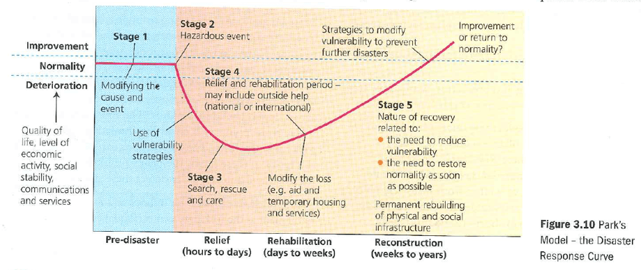
Describe the different models of assessing the response to a natural disaster:
Disaster risk Management cycle:
mitigation (decrease future impacts)
Preparedness (planning)
Response (how we react)
Recovery (getting the place back to normal)
Disaster response curve: shows how different events can have different impacts
pre disaster
disruption ( decreases quality of life)
Relief (rescue effort)
Rehabilitation (long term aid)
Reconstruction (rebuilding to better standards)
Describe the nature, impacts and responses to Mt Ontake:
Mt Ontake: phreatic (steam explosions as water interacts with hot rock), pre-tremours not enough to trigger high alert,
Impacts:
63 killed
Flights cancelled and disrupted
Ash covered 3km down mountainside
Ski resorts closing = long term decline of tourism
Faith lost in GOV: 2 faulty seismographs
Responses:
Japanese self defense force rescued 31 people
Aid sent from China + USA
200 men built rubber lava barrier/ diversion, $3million built later
Evacuation plans improved: Concrete bunkers built, climber safety packs given
Afforestation projects to damaged areas
Gov improved monitoring by reorganizing Japan Meteorological Agency (more staff and resources like Global Navigation Satellite Systems)