PSA senior cadet interview prep
1/58
There's no tags or description
Looks like no tags are added yet.
Name | Mastery | Learn | Test | Matching | Spaced | Call with Kai |
|---|
No analytics yet
Send a link to your students to track their progress
59 Terms
What docs does an aircraft need
A - airworthiness (never expires)
R - Registration (7years)
R - Radio operating license (if international)
O - Operating hand book (aircraft specific)
W - Weight and balance (aircraft specific)
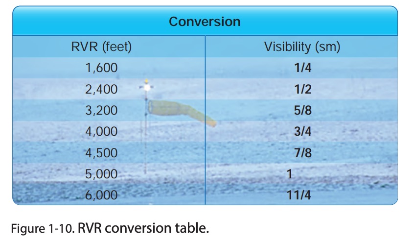
RVR
runway visual range - horizontal distance you can see down a runway
IFR required equipment
ATOMATOFLAMES + FLAPS:
G - generator/alternator
R - radio (two way, nav)
A - altimeter (sensitive)
B - ball (inclinometer)
C - clock (integrated, hr, min, sec)
A - attitude ind
R - rate of turn gyro (turn cord)
D - directional gyro (heading ind)
What is a MEL
A minimum equipment list - an FAA approved list of equipment the aircraft can fly without
IFR fuel requirements
destination, to the furthest alternate 45 minutes at normal cruise
taxiway lighting
Taxiway Edge Lights - Steady blue lights outlining the edges of taxiways
Taxiway Centerline Lights - Steady green lights installed along the centerline of the taxiway
Clearance Bar Lights - Three in-pavement steady-burning yellow lights
Runway Guard Lights - Pair of elevated flashing yellow lights on either side of the taxiway, or a row of in-pavement yellow lights across the entire taxiway at the runway holding position marking
Stop Bar Lights - A row of red, unidirectional, steady-burning in-pavement lights across the taxiway at the runway holding position, and elevated steady-burning red lights on each side
Taxiway Centerline Lead-on Lights - Provide visual guidance for entering the runway, alternating yellow and green Bidirectional (1 side emits light for the lead-on function the other for the lead-off)
Alternate rule
When do you need an alternate, if the conditions are worse than:
1 hr before and after eta:
2,000 ft ceilings
3 sm vis
Approach mins:
Precision - 600ft ceilings, 2 sm
Non-precision - 800ft ceilings, 2 sm
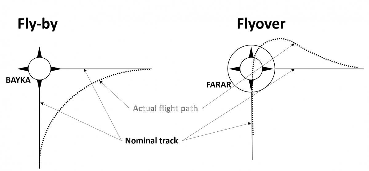
way points
fly over - Fly−over waypoints are used when the aircraft must overfly the waypoint prior to starting a turn to the new course.
fly by - Fly-by waypoint allows the aircraft to turn before reaching the waypoint for a smoother, more efficient flight path
What makes an ILS system
Guidance information
Localizer (LOC) : provides lateral guidance
Glideslope (GS) : provides vertical guidance
Range information
Marker beacon
Outer Marker (4-7miles from airport to intercept GP) = low-pitched tone, continuous dashes, two dots per second, blue light
Middle Marker (3500’ from landing threshold / 200’ above TDZE) = intermediate tone, two dashes or six dots per second and amber light
Inner Marker (Between MM and runway threshold - DH) = has a pattern of a series of dots in frequency of 6 dots per second, white light
DME
Visual information
Approach lights
Touchdown and centerline lights
Runway lights
Localizer frequency & identifier
You can see it up on the top of the approach plate it will say LOC followed by a frequency
If it has DME capability it will say LOC/DME or if a TACAN channel is listed
runway lighting
Runway End Identifier Lights (REIL) - Installed to provide rapid/positive identification of the approach end of a runway, sit next to threshold, flashing lights
Runway Edge Light Systems (HIRL, MIRL, LIRL) - Outline the edges of runways during dark / restricted visibility conditions
Runway edge lights – White
Instrument runways – Yellow for the last 2,000,’ or half the runway, whichever is shorter
Lights marking the end of the runway – Red / Green
Runway Centerline Lighting System (RCLS - installed on some precision runways to facilitate landing under adverse conditions
White lights alternate with red for 2,000’, and the last 1,000’ all lights are red
Touchdown Zone Lights (TDZL) - On some precision runways to indicate the touchdown zone in low visibility conditions, white
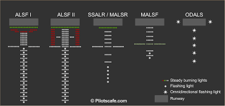
approach lighting
ALSF (Approach Light System with Sequenced Flashing Lights): A high-intensity system used for precision approaches. ALSF-1 is for ILS Category I, while ALSF-2 is for Categories II and III.
SSALR (Simplified Short Approach Lighting System with Runway Alignment Indicator Lights): A simplified version that can be used during instrument approaches to provide alignment guidance.
MALSR (Medium Intensity Approach Light System with Runway Alignment Indicator Lights): A medium-intensity system that provides alignment, height perception, and roll guidance.
ODALS (Omnidirectional Approach Lighting System): Consists of seven flashing lights that can be seen from any direction, making it useful for non-precision approaches.
VASI (Visual Approach Slope Indicator): A system of lights that provides visual descent guidance to indicate if the aircraft is too high, too low, or on the correct path
when can you go below minimums?
91.175
Operation below DA/DH or MDA: Except under special provisions (see § 91.176 for EFVS operations), a pilot may not continue an approach below the authorized MDA, or descend below the authorized DA/DH, unless:
the aircraft is in a position from which a descent to land on the intended runway can be made at a normal rate using normal maneuvers;
flight visibility is at least the minimum prescribed for that approach;
one of the required runway‐environment visual references is distinctly visible and identifiable (e.g., threshold, runway lights, visual glideslope indicator, etc.)
The approach light system, except that the pilot may not descend below 100 feet above the touchdown zone elevation using the approach lights as a reference unless the red terminating bars or the red side row bars are also distinctly visible and identifiable
holds
standards
turns to the right
the inboud leg will always be towards the fix/navaid
normal - 1 min legs
gps - 4nm legs
entries
direct
parallel
teardrop
hold speeds
6000 ft - 200kts
6001ft - 14,000 - 230kts
14,001 - 250kts
What considerations should you have in a hold
Fuel, Time, and whether it’s better to divert or to hold fuel-wise
If you divert, go to an alternate with American Eagle services
how can you ID a missed approach
with DME / TIMED / Marker beacons
take off alternate 121
if your minimums at your takeoff destination are below you a take off alternate and it needs to be within an hour
below a 200ft celling
what are some considerations when taxing
hot spots, hold short positions, other airplanes, getting checklist done
What is the difference between climb/descend and maintain or climb/descend via
climb/descend and maintain; cleared laterally, not vertically, follow their instructions
climb/descend via; cleared laterally and vertically to the top altitude or lowest altitude
airspeed restrictions will always be applicable with both, unless ATC modifies
multi system
what is the final approach fix for a precision vs non perscision
precision - glide slope intercept
non perscicion - the malteese cross
Going below minimums 121.651
If the reported weather drops below landing minimums before you pass the FAF, you may NOT continue the approach You must go missed / discontinue the approach.
If the weather was at or above minimums when you passed the FAF, and then drops below minimums after the FAF,
You may continue the approach to DA/MDA and attempt a landing.
departure procedures
Simplify clearance delivery procedures
reduce frequency congestion
ensure obstacle clearance
help control airport traffic flow
from the terminal to en route structure
textual or graphical
climb gradients
Adhere to the terps ensures the climb meets obstacle clearance
must make sure your aircraft is capable
FPNM = (FPM/GS) x 60
FPM = (GS/60) x FPNM
TERPS & TPP
US Standard Terminal Instrument Procedures - provides design criteria for procedures
terminal procedures publication - the published procedures
Standard Instrument departure SID
reduces pilot controller workload
expedites traffic flow
obstacle clearances
textual or graphical
this departure terminates at the fix or navaid in the enroute structure and a altitude where atc can give radar services
ATC can issue SIDs pilot can request no sid in remarks
name includes abbreviated name, number, name of transition/fix
starts with departure than transition ex MOLEN8.ENI
pilot navigation SID
pilot navigates along specific route with minimal communication
typically includes initial headings, altitudes, transition and departure routes
vector SID
an area where controllers typically provide radar service
vectors start after takeoff and continue to assigned route or fix in the chart
typically includes initial headings, altitudes, loss com procedures, fixes
RNAV SID
airplane must meet certain equipment and performance standards
RNAV is included in the procedure name
can be solely pilot navigation or a mix of vectors as well
Has fly by and fly over way points
minimum safe sector altitude MSA
provides 1,000 ft obstacle clearance for non/mountainous areas
25 nm radius around a defined point
Minimum off route altitude MORA
a grid which provides 1,000 ft obstacle clearance (2,000 mountainous) above the highest terrain or man made structure
obstacle departure procedure
created when the required climb gradient or takeoff minimums is higher than standard for obstacle clearance
you can fly and ODP without a clearance as long as no other departure has been assigned
Jeppersen places textual ODP in the airport information charts
diverse vector area DVA
In a radar environment, ATC can take responsibility for obstacle clearance by vectoring aircraft before the minimum vectoring altitude
no specific ground track, climb gradient denoted if higher than standard
Jeppersen places textual DVA in airport informatin charts
take off 91.175
weather conditions must be higher, or at takeoff minimums for that airport if none is published
for 1-2 engines 1SM
for 3 or more ½ sm
can be lower if authorized by opspecs, and you have the required equipment and visuals
arrival charts
provide transition between enroute structure to busy terminal areas
simplifies clearance delivery procedures
expected action for pilots and controllers
standard terminal arrival STAR
simplifies clearance delivery procedures
Typically ends at a fix where an instrument or visual approach
starts at one point where all the transitions converge also is what the arrival is named after
Atc can issue a STAR you can request no star
starts with transition, then the name of arrival, ex, LAX.HUBRD1
a transition
one of several routes that bring traffic from different directions to a point where the star begins
transition route vs routing
transition route - dashed line
routing - solid black line
RNAV STAR
airplane must meet certain equipment and performance standards
RNAV is included in the procedure name
Has fly by and fly over way points
instrument approach procedure IAP
precision approach PA
provides vertical and lateral guidance with specific standards for integrity and accuracy
approach with vertical guidance APV
provides vertical and lateral guidance
nonpercision approach NPA
provides only lateral guidance, vertical descent has to be calculated
initial approach segment IAF
aligns aircraft with approach course
intermediate approach segment IF
potions aircraft for final descent
final approach segment FAF/FAP
descent down to a point where if you have 91.175 you can continue approach to landing
da vs mda
decision altitude - alt at upon reaching you either continue or go missed
minimum decision altitude - alt upon reaching that you can maintain until MAP or continue
missed approach segment
route from missed approach point where you can attempt again or divert
missed approach point
the point at which you go missed
can be identified as a fix, navaid, dme or an elapsed time
terminal arrival area TAA
provides transition from enroute structure to terminal area for RNAV equipped aircraft
provides obstruction clearance as long as ur at or above published minimum alt
feeder route
provide a link between a enroute fix or navaid to the initial approach fix
course reversal
procedure turn - can be completed in any way as long as your on the right side and within the specified distance
hold/teardrop - must be done that way
none - no procedure turn is authorized
visual descent point
a point from which if you are visual you can descend below you MDA
descent/timing conversion table
provides time and distance and recommend descent from the FAF to the MAP based on GS
inoperative components
typically raise minimums can be found on the jep plate
if multiple components are out you choose the highest minimum required by a single component
airport reference point
center of all usable runways, it where the gps takes you
RNAV approaches
require gps equipment
tso 129 & 196 provide lateral navigation (raim)
tso 145 & 146 provide lateal and vertical navigation (waas)
utilizes gps generated points (fly by fly over)
ILS approaches
provides course gs and distance
CATI - standard ILS approach must be instrument rated and have equipment
CATII - gets you to a DH of not less than 100ft about TDZ and RVR of 1,200ft
CATIII - has 3 separate categories
IIIa - 700ft rvr
IIIb - 150 rvr
IIIc - no rvr
CATII & III require special equipment and certification
prop system
When the rpm setting is set:
airplane's nose is raised / under speed conditions:
airspeed and rpm go down due to increasing drag
so to counteract fly weight goes into an underspeed condition
moves the pilot valve down allowing oil flow into prop hub
more oil
decreases blade angle - closer to windmilling - low aoa
pilot valve will return to nuetral when condiiton is fixed
airplane nose lowered / overspeed condition:
airspeed and rpm increase due to decreasing drag
fly weights go into overspeed condition
moves the pilot valve up allowing oil to return to engine
less oil
Increases blade angle - closer to feather - high aoa
pilot valve will return to nuetral when condition is fixed