Exam 2 - Geological Oceanography
1/122
There's no tags or description
Looks like no tags are added yet.
Name | Mastery | Learn | Test | Matching | Spaced |
|---|
No study sessions yet.
123 Terms
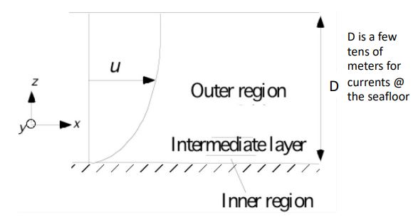
Bottom Boundary Layers
The layer (of thickness D) in which velocities change from zero at the boundary to a velocity that is unaffected by the boundary
Outer region
Intermediate layer
Inner region
Turbulence
can keep sediments afloat
Suspended Load
particles that are kept floating during turbulence
Bed load
particles that are moving (sliding and rolling) on the sea floor during turbulence
Using sediments to measure currents
where currents meet obstacles, currents speed up and reduce sedimentation or start eroding
moat
forms around obstacles with an increased deposition in the lee of the obstacle
ripples
perpendicular to direction of flow and is effective at sorting sediments by density, grain size (peaks prominent close to time of formation from a storm)
current generated ripples
asymmetrical gentle slope upcurrent side, steep on downcurrent side
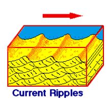
Wave generated ripples
oscillatory motion creates symmetrical ripples wavelength increases with wave period

Beach composition affects slope
fine grain → Coase grain
Mud → Sand → Shingles (gravel size to cobble size)
Angle of repose
steepest angle dry sediment can stand without sliding
steep (11 degree) vs. shallow (0.5 degree)
Permeability
measure of the ease of fluid flow through sediments (Grain size and sorting)
smaller grain size is more compact leading to less permeability
larger grain size is less compact leading to more permeability
infiltration
movement of water down into the water table due to runup
drawback
smaller grain size reduces permeability thus reducing infiltration, as well as steeper beach, leading to more ______.
larger saturated zones
tide drops faster than the water table can dry out
outer region of the bottom boundary layers
affected by the outer flow (or free surface) (1-10 m)
intermediate layer of the bottom boundary layers
both far from outer edge and wall (log layer) (~0.1 m)
erosion
increases angle relative to angle of repose
deposition
degreases angle relative to angle of repose
inner region of bottom boundary layers
is dominated
Conditions favorable to erosion
saturated sand tends to erode
in water, effective density reduced
Waves: Moderate to large height, short period (8 secs)
sand: low permeability
Conditions favorable to deposition
Waves: Moderate height, long period
Sand: High permeability
Sources of Sediments
Erosion of rocks at shore
Biogenous sediments
Bioerosion (fish)
Erosion (waves smacking into coral)
Runoff
Cliffs
Low sediment supply beaches
Lag beach
Beach rock
High energy beaches
gravel beach
storm beach
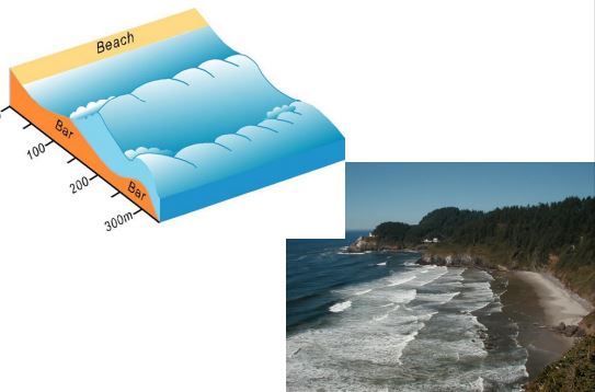
Dissipative
beach state which multiple sand bars that create multiple wave crests
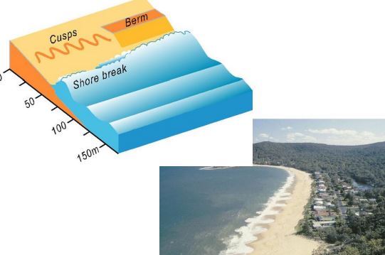
reflective
beach state which waves break right on the shoreline and slope is much steeper
Intermediate
beach state with moderate waves and fine to medium sand. They are characterized by a surf zone with one or two sand bars. The sand bar is usually cut by rip channels and currents
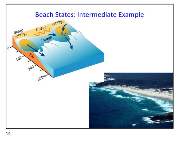
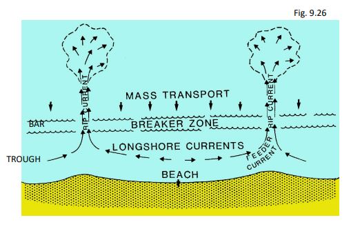
Surf zone circulation
complex circulation cells develop in the presence of waves at the shoreline
resuspension
the process of moving previously deposited sediment particles from the bottom of a body of water into the water column
silt
wave motion too strong for the particle and gets moved back out to sea by riptides
High supply
deposition>erosion (Bays)
wave activity sorts sediments
Low supply
Headlands
lag or rocky beach
intermediate supply
deposition = erosion
grain size may fluctuate seasonally
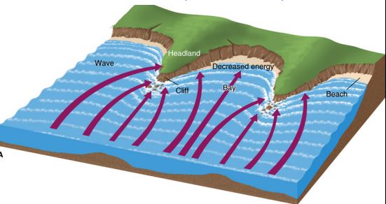
wave refraction
causes increased erosion at headlands, deposition in bays
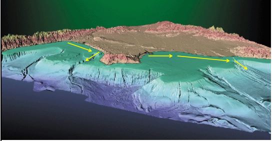
Littoral cell
sediments are transported alongshore, then move offshore @ submarine canyons
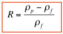
Submerged specific gravity
Vertically downwards of Pp > Pf
Upwards if Pp < Pf
coal/flocs
submerged specific gravity = <0
Magnetite
submerged specific gravity = 4.1
Olivine
submerged specific gravity = 2.3
Quartz and kaolinite
submerged specific gravity = 1.6
Stokes settling
two forces act on a sinking particle:
Gravitational (Fg)
Drag (Fd)
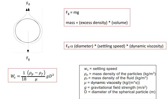
Limits of stokes
assumes smooth spherical particles - rough particles settle more slowly
No grain-grain interference
dense concentrations settle more slowly
Flocculation
Assumes laminar flow
ignores turbulence
important for coarse sand and larger
Flocculation
joining of small particles (especially clays) as a result of chemical and/or biological processes
Marine snow
Larvacean houses
fecal aggregates from zooplankton
diatom floes formed at the end of blooms
aggregates formed in aging systems from unidentifiable debris
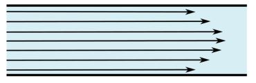
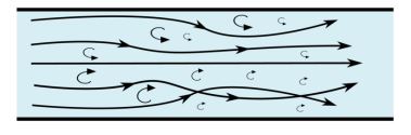
laminar vs. turbulent flow
most flows generate turbulence
Laminar flow
a type of fluid flow where fluid particles move in parallel layers without fluctuations or mixing
turbulent flow
a type of fluid flow where the speed of the fluid at a point in continuously undergoing changes in both magnitude and direction
sediment waves
vary from small to large
wave height: few cm - 200 m
wave length: few cm - <10 km
eustatic sea-level
global sea level
relative sea-level
local sea level
magnitude of sea level change
Max: ~100-<200 m
Transgressions
Landward migration of the shoreline
sea level rising
Regressions
Oceanic migration of the shoreline
sea level dropping
high sedimentation rates @ river deltas (local regression)
tend to be thinner because of erosion/disconformity
Disconformity
a period of time with no sedimentation, likely erosion
Break in the geologic record above regressions
sea level change in geologic record
Transgressions
Regressions
Break in record above regressions
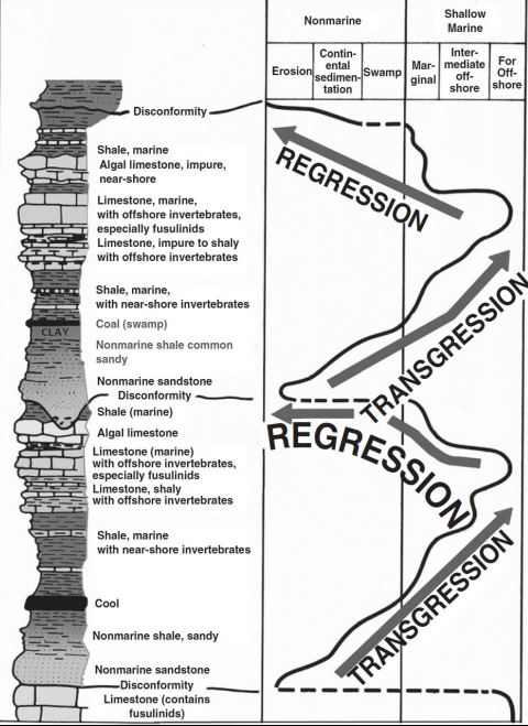
Seismic reflection (sea level changes)
Transgressions
sediment strata wider, shallower
Regressions
Erosion on the shelf (hiatus)
Deeper accumulation
Slow mid-ocean ridge spreading
oceanic crust cools and contracts
Sea level will be lower
Atlantic ocean
fast mid-ocean ridge spreading
More hot, buoyant oceanic crust occupies more space in the ocean basin
Faster spreading when no continental collisions
Sea water displaced onto continental shelf
Sea level will be higher
Pacific ocean
Plate tectonics control
continent thickness determines how much is exposed
Continental collisions lead to thickening of continental crust
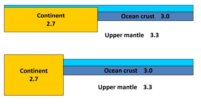
Changes in shape of ocean basins
Tectonic
Million-year (Ma) Time scales
Land and shelves
continents shrink
lower sea level
when collision happens
higher sea level and sedimentation
continental area increases when continents break apart
Continental-scale glaciations
Glaciers ~2km thick
LGM: Enough ice to lower sea level by 125 m
fast sea level change
happening on ka time scales
eustatic sea level changes
Continental-scale glaciers (form, melt)
Changes in temp (colder water = higher density)
Regional sea level changes
post-glacial rebound
regions are still adjusting to ice loss from the last glacial maximum (15 ky)
ex) Alaska and Scandinavia (subsidence of the northern sea)
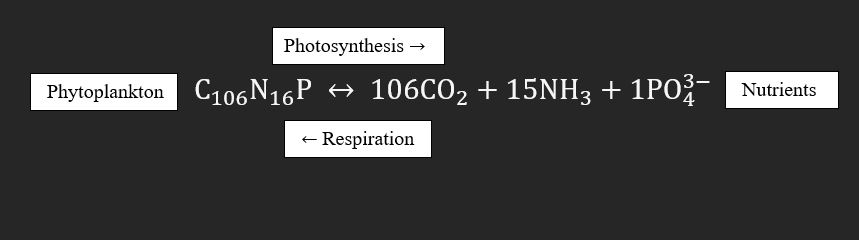
Biological pump
organic matter produced by photosynthesis in the surface ocean dies and sinks, transferring (“pumping”) organic carbon and nutrients into the deep sea
bio pump removes
carbon nutrients from the surface
bio pump increases
carbon nutrients in the deep sea
bio pump provides
food to deep sea life
Redfield Ratio
C:N:P = 106:16:1
ocean productivity where?
coastal-eastern boundary current
Equatorial upwelling
polar upwelling
ocean productivity why?
upwelling
how ocean productivy change
El Niño (change of winds) potentially less upwelling
Upwelling
Localized
Driven by:
Winds and Coriolis effect
Bring up water from depths of a few hundred meters
Coastal upwelling important for oil, gas formation
Export C/Production
Data from sediment traps deployed at different depths
Carbon flux decreases with depth as organic matter is consumed by detritovores and bacteria
Remineralization
Respiration
release nutrients
Transfer of Carbon to sediments
Open Ocean
10% sinks out of the “fertile zone”
Photic zone + region immediately below
1% reaches the seafloor
0.03% accumulates in sediments
Increase export
phytoplankton in a large population produce larger fecal pellets that get transported to deep ocean
Burial of carbon
anoxic water column turning off respiration which organisms can’t intake increasing burial
Diatoms and export production
Require silica
dominate in upwelling regions
Large-shorter food chain to big fish
Rytherʻs Principle
During blooms
export C/Production ~50%
Greater preservation in sediments than organic carbon
What does it mean when we say a sediment has a high silica content?
diatom or radiolarian rich sediment (upwelling/nutrient rich areas)
What do carbonate-rich pelagic sediments tell us?
forams or nannofossils (coccolithophores) oozes
What do sediments with no fossils tell us?
anoxic conditions
Namibia Upwelling
SW Africa, Atlantic Coast
Upwelling identified by cold temperature anomaly
Matuyama Diatom Maximum
Matuyama-Magnetic Chron
Glaciation of Greenland
Mats form with rapid sedimentation through the water column
Matuyama-Magnetic Chron
2.5-0.7 Ma
Olduvai sub-chron: 2.0 Ma
Glaciation of Greenland
3-2.5 Ma
Mats form with rapid sedimentation through the water column
Export X/Production >50%
Namibia Coast Matuyama Diatom Maximum
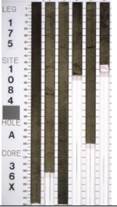
316.3-325.9 mbsf
olive (5Y 4/3)
Diatom-bearing nannofossil clay
Section 1, 90 cm, to section 3, 65 cm; section 4, 15 cm, to the end of the core
dark olive gray (5Y 3/2)
foraminifer-bearing diatomaceous clayey nannofossil ooze
Name:
Least Abundant first
“Bearing” = 5-10%
Most abundant last
ooze = >60% biogenic
We study modern reefs because…
Current geological processes can be used to interpret the rock record
Uniformitarianism: everything happens continuously through time
exceptions: catastrophism is the theory that the Earth has largely been shaped by sudden, short-lived, violent events, possibly worldwide in scope.
Reefs Are…
Constructed of biologically-produced material (framework)
Rigid structure
interlocked and in place framework
reworked framework bound together by secondary encrustation or cementation
Stands topographically above the surrounding seascape, exerting at least local control on oceanographic processes
Majority of the framework were formed in an environment similar to thee one in which they were ultimately deposited
Coral reefs
secretion of calcium carbonate by living organisms, forming rigid structures that stand above the seafloor
types of reefs
Oysters
Coralline algae
Paleo-reefs
Bivalves
sponges
stromatolites
Optimal Conditions coral reefs
warm water (>20˚C)
High salinity
low nutrient
Pile of rubble
Interlocking framework of broken organic hard parts
Primarily coral
Bioherm
Massive, mound-shaped biological accumulation
single species or organism
% recognized coral
14-25%