How are waves formed
Wind blowing over the surface causing friction
The friction produced swells in the water
Energy of the wind caused the water particles to to rotate inside the swell carrying the energy to move the wave forward
The wave is created through friction and transferring between wind and water generating ripples which grows into waves
factors influencing the size of a wave
fetch: the distance over which the wind had blown interrupted
Water depth: limited friction with the seabed means uninterrupted internal orbit of water particles
Strength of the wind: local weather systems generate powerful wind that is transferred to the water surface
How to marine processes and wave shape the coastline
constructive and deconstructive waves
Various waves hitting a beach during different seasons or storm conditions
Climate change creating stormier conditions
Dams preventing sediment being transported from rivers so erosion increases
Interfering of natural processes through human activity which affects sediment supply
How can beach profiles change
sediment supply from rivers is reduced (eg dams)
Interference of sediment supply from coastal management
Chnages in climate eg global warming creating stormier conditions
Describe how waves are in the open sea
Waves are energy moving through water.
The water itself only moved up and down not horizontally.
There is an orbital water particle motion but no forward motion
Describe how a wave breaks
When waves reach the shore they reach a wave depth of ½ their wave length. The orbital motion starts touching the sea bed. Friction begins to distort the waves slowing down as it enters the offshore zone. The wave depth decreases further, velocity slows the wavelengths shortness and height increases and wave bunches together. The wave crust begins to move forward faster than the wave trough. Eventually the wave crest outruns the trough and the wave toppled forward breaking the wave. It breaks in the nearshore and water flows up the beach as a swash. Wave looses energy and gravity pulls the water back down the beach as backwash
Describe constructive waves
strong swash weak backwash
Low wave height
Long wave length
Low frequency
Deposition
Describe destructive wave
strong backwash weak swash
High wave height
Shirt wave length
Erosional
Describe seasonal beaches
Winter brings stronger winds and high energy waves while summer waves are low j energy but high in swell
How are tides formed
Formed by gravitational pull of the sun and moon acting on the waters surface. Tides are produced as a bulge of water rotated around locations in the ocean called amphidromic points.
As the builder passes a location on the coast a high tide occurs which happens twice a day over a 12 hour interval
In a sea with no waves water at the coast would rise and fall with little force
some locations have large tidal ranges that provide tidal bored capable of erosion
When storms occur during spring tides (highest tides) storm waves can act on parts of coastlines that would not normally experience them increasing risk of flooding
What are types of erosional processes
hydraulic action
Abrasion
Attrition
Solution/corrosion
Describe hydraulic action and its lithology
Air trapped in cracks is compressed by the force of waves crashing against the cliff face. Pressure forces the crack open in the next cycle. This process despisers blocks of rock from the cliff face.
Lithoogy: heavily jointed sedimentary rocks are vulnerable. This is the only process operating on very hard igneous rocks (eg basalt and granite)
Describe abrasion and its lithology
sediment picked up by Breaking waves is thrown against the cliff face. Sediments cut at the surface wearing it down by removing small particles
Lithology: loose sediment (shingles or pebbles ) softer sediment is more vulnerable than harder ones
Describe attrition and its lithology
Acts on already eroded sediment. As sediment is moved by waves collisions between particles chip fragments off the sediment. Sediment gets smaller and more rounded overtime.
Lithology: softer rocks are rapidly reduced in size by this
Describe solution / corrosion and its lithology
Carbonate rocks (limestone ) are vulnerable to solution by rainwater and spray from sea water
Lithology: mainly affects limestone which is vulnerable by weak acids
Describe the processes of the holderness cell
sources: where sediment is eroded from cliffs. Chalk from Flamborough Head and clay from Hornsea boulder. They can also be sand dunes or river systems such as from the river Humber
Transfer zones: places where sediment is moving along the coast from long shore drift and offshore surrender. Beaches, parts of dues and salt marshes such as the Humber Estuarydoes this
Sinks: where depositions is the dominant process such as in spits like the Sourn head and offshore bars
How do sediment cells maintain balance use the Holderness coast as an example
Sediment cells operate as a system in a state of dynamic equilibrium. Negative feedback maintains balance such as in major storm events. Parts of cliffs collapsed but chalk or boulder clay slows erosion by protecting the cliff from wave attacks
Major erosion of the Spurn head spit can lead to increases deposition offshore creating an offshore bar that reduces wave energy allowing the spit to recover
How does positive feedback effect the sediment cell in the Holderness coast
Positive feedback leads to disequilibrium in the coastal systems
human interaction from coastal management threatens the coast
Increases storms eroding beach material faster so recent debris never protects the cliff base
Rising sea levels increase erosion of sits like spurn head removing sediment faster than it can be replaced
How does groundwater affect cliffs
Groundwater weakens rocks by removing the cement that binds sediment in the rock together.
Water emerging from below the ground into a cliff face at a spring can run down the cliff face and cause surface run off erosion weakening the cliff
What are the three types of dip cliffs profiles
horizontal dip
Seaward dip
Landward dip
Describe horizontal do
Vertical or near vertical profile with notches reflecting weathering and small scale mass movement of strata that are jointed or easily eroded. There’s lots of erosion
Describe seaward dip
Above 45 degree angle producing sloping vulnerable to rock slides when attacked by Sun Ariel processes. Lower angles produces a steep profile creating an area of overhang rock that are very vulnerable to rock falls. Major cliff collapse when there’s undercutting by Marie erosion making overhand unstable. Overall there’s lots of mass movement
Describe landward dip
Produced steep profiles 70-80 degrees as downslope gravitational force pulls loosened blocks into place
Very stable profile with few rock falls
What are four other features of dip cliff profiles
joints
Faults
Folds
Fissures
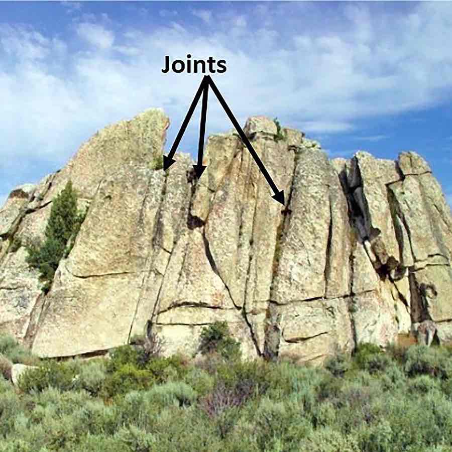
Describe joints
Fractures in rocks created without displacement (action of moving something from its position). They occur in most rocks often in regular patterns dividing rock strata up into blocks with a regular shape. Joints increase erosion rates by creating fissures which marine erosion such as hydraulic action can exploit
in igneous rocks cooling joints form when magma contracts and it looses heat
In sedimentary rocks joints form when gets compressed or stretched by tectonic forces or weight of overlaying rocks
When overlaying rock is removed underlying strata expands and stretched creating unloading joints parallel to the surface
Describe faults
Major fractures in rock created by tectonic forces
Often large scale extending many Km
Significantly increases rate of erosion since zone of faulted rock are easily eroded
Huge forces are involved so either side of the fault lint rocks are heavily fractured and broken which is easily exploited by marine erosion
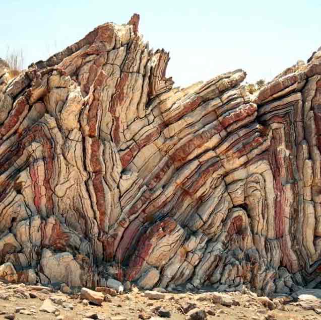
Describe folds
Bends in rock produced by sedimentary rock layers being squeezed by tectonic forces
Two main types are anticlines and synclines
Folded rocks are more heavily jointed and fissured so they are more easily eroded
Increases erosion rates by increasing dip angle
What are the four shores of the Littoral zone
back shore
Foreshore
Nearshore
Offshore
What are the three coastal types
advancing coastlines
Retreating coastlines
Stationary coastlines
Describe the 5 distinctions between the three main types of coasts
rocky coastlines: has cliffs varying in height, cliffs are formed by rocks but their hardness is very variable
Coastal plains: the land gradually slopes toward the sea across an area of deposited sediment with sand dune and mudflats being the most common example. These can be referred to as alluvial coasts
Cliff coasts: the transitions from land to sea is abrupt. At low tide the foreshore exposed a rocky platform (wave cut platform)
Sandy coastlines: at high tide sand beaches are overwhelmed but the vegetated dunes are not. The dunes stabilise the coast
Estuarine coastlines: found at the mouth of rivers. Extensive mudflats cut by channels are are exposed at low tides but overwhelmed at high tides. Closer to the back shore the mudflats are vegetated forming a salt marsh. Gradually transitions from land to sea
Describe the four classification of coastal environments
formation process:
primary coasts: dominated by land processes
secondary coasts: dominated by marine erosion or deposition processes
Relative sea level change:
emergent coasts: when the coast is rising during sea level change eg due to tectonic lift
submergent coasts: being foooded by the sea by rising sea levels
Tidal range
microtidal coasts: (range of 0-2m)
mesotidal: (2-4m)
Macrotidal coasts (>4m)
Wave energy
low energy: sheltered coasts with limited fetch and low wind speeds resulting in small waves
high energy: exposed coasts, facing prevailing winds with wave fetched resulting in powerful waves
Name the different erosional landforms
caves, arches and stumps
Wave cut notch and platforms
Retreating cliffs
Blowholes
Describe the process of caves arches and stumps
Occurs on headlands. Marine erosion widens fault in a base creating a cave. It eroded to the other side from marine erosion and sun Ariel processes creating an arch. Arch widens until it can’t support its weight collapsing from mass movement. This leaves a stack which eventually collapsed to a stump through marine erosion
Describe the process of a wave cut notch and platform
Marine erosion attacks the base of the cliff creating a notch between high and low tide. As it deepens and Sub Ariel weathering weakens the top, it collapsed leaving an unaffected platform below the notch
Describe the process of retreating cliffs
Through wave cut notches and platforms new cliff faces are created whilst the land retreats
Describe the process of a blowhole
A combination of a pothole on top of a cliff from chemical weathering and a cave from marine erosion. as a cave eroded and the pothole deepens they may meet creating a channel for incoming waves to travel in and up the cliff face so the water occasionally splashes out
describe the 5 processes of transportation
longshore drift: wave hits the beach at an angle due to wind, sediment is carried up by the wash and gravity carries it back down by backwash
Traction: large heavy sediment rolling along the seabed usher by currents
Saltation: smaller sediments bounce along the sea bed pushed by currents
Suspension: small sediments carried in the water
Solution: dissolved material carried in the water
Describe the two affects of transportation
The impact of transportation depends on the angle that waves travel on land
swash aligned: waves approach the beach parallel to the coast so there is limited longshore drift and sediment doesn’t travel far
Drift alinged : wave approaches at and angle so longshore drift causes sediment to travel
Describe 6 depositional landforms
spits: formed by deposition. Longshore drift deposits sediment as wave looses energy . As winds change direction this causes a hook sheltered aren behind the spit which turns into a salt marsh . The length is determined by surrounding currents or rivers
Bars: a spit that crossed a bay and links up two sections of the coast. Water within the bay is called a lagoon
Tombola: a bar/beach connecting the mainland to an offshore island and fairies due to wave refraction off the coastal island reducing wave velocity leading to deposition of sediment. They can be covered at high tide if they’re low lying
cuspate forelands: only occurs with triangle shaped headlands. Longshore drift along each side of the headland and will create beaches where they meet will form a cusp ste fore land
Offshore bars: a region offshore where sand is deposited as waves have low energy
Sand dunes: prevailing winds blow sediment to the back of the beach . The require large quantities of sand and a large tidal range allowing sand to dry so it’s light enough to be picked up by wind and carried to the back of the beach
Describe the likelihood off deposition
gravity settling: the waves energy becomes very low and so heavy rocks and boulders are deposited followed by the next heaviest sediment
Flocculation: clay particles clump together due to chemical attraction and then sinks due to high density
Describe the three weathering recesses
mechanical/physical weathering
Chemical weathering
Biological weathering
Describe the process of chemical weathering
Breakdown of rocks through chemical reactions
carbonation: rainwater absorbs CO2 to create a weak acid that reacts with calcium carbonate in rocks
Oxidation: minerals exposed to air through cracks will become oxidised increasing its volume causing the rocks to crumble. Vulnerable rocks are sandstone, siltstones and shales
Hydrolysis: the breakdown of minerals to form new clay minerals plus materials in solution due to the effect of water and dissolved CO2. Vulnerable rocks are igneous and metamorphic rocks contains feldspar and other silicate minerals
Describe the process of biological weathering
Breakdown of rocks through plants bacteria or animals
plant roots: roots growing in cracks exerting pressure splitting rocks. Vulnerable rocks are vegetated cliff tops that can contribute to rockfalls
Rock boring: clams secrete chemicals that dissolve rocks and piddrocks may burrow into the rock face . Vulnerable rocks are sedimentary rocks especially carbonate rocks like limestone.
Seaweed acids; some seaweed contain sulphuric acid which if hit against rock the acid will dissolve some of the rock minerals
Decaying vegetation: water flowing through decaying vegetation is acidic causing chemical weathering
What do types of mass movement depend on
angle of the slope/cliff
Rocks lithology and geology
The vegetation cover on the cliff face
Saturation of the ground
Previous weather patterns
What are 4 types of mass movement
rock fall
Topple
Translational slide
Rotational slide/slumping
Describe the process of rockfall
A rapid form of mass movement
Describe the processes of mechanical/physical weathering
breakdown of rocks due to physical factors without chemical changes
freeze thaw: water enters, freezes, expanding the water and increasing pressure causing cracks. Any rocks with cracks high up a cliff are vulnerable
salt crystallisation: sea water evaporates leaving salt that will grow exerting pressure forcing rocks to widen. Salt can corpse ferrous rock due to chemical reactions. Permeable and fractured rocks are vulnerable . The effect is greater in hotter crier climates where evaporation and precipitation is more pronounced
weathering and drying: rocks like clay expand when wet and contracts when drying. Frequent cycles of this can cause rocks and cliffs to break up
Describe the process of rock topple
Geological structures often influences topple. Rock strata have a very steep seaward dip so undercutting by erosion will quickly lead to instability and block of material toppling seaward.
Describe the process of transitional sliding
A very low angle Seward dip in strata will prevent falls but encourages rock and transitional slides. Material will tend to slide down towards the sea.
Describe the process of rotational slide/slumping
Are common in weak rocks such as clay or unconsolidated sands. These materials become saturated and flow downslope. Heavy rain and high tides can contribute to saturation
This type plot mass movement is difficult to manage as it can have multiple causes. This leads to failure deep within the cliff material. The most vulnerable situation is where permeable strata sits on top of impermeable strata
Bedding plane between impermeable clay and permeable sand dips seaward promoting mass movement
Crack develops in dry weather where rain water can go down the sand
Heavy rain stuarted the permeable sand loading the cliff material
Heavy rain filters through the permeable sand but is forced to move along the sand or clay boundary as the clay is impermeable. This contributes to high pore water pressure in the sand and creates internal pressure within the cliff
Toe erosion by marine erosion ( abrasion, hydraulic action)processes undercuts the cliff from below adding to instability
Curved failure surfaces develop in the sand and the whole cliff begins to rotate about a pivot point
How can rocks be vulnerable to sun Ariel processes
Temperature and climate can influence weathering. In colder climates weathering is more common. In warmer climates chemical weathering is more common
What are cliff profiles influenced by
the resistance of rock to erosion
The dip in rock strata to the sea
What are the different types of coastal vegetation
coastal sand dunes
Coastal salt marshes
Coastal mangrove swamps
How does vegetation stabilise sediment
roots bind sediment making them harder to erode
When submerged plants growing in sediment provide a protective layer so the surface of the sediment is not directly exposed to moving water and therefore erosion
Plants protect sediment from wind erosion by reducing wind speed at the surface due to friction
Describe the process of plant succession
A long Term change in a community or area.
on a coast with sediment where deposition can occur pioneer plants grow in mud and sand. Due to salty conditions only certain plants can grow
As more deposition occurs and vegetation dies and releases nutrients that reduces the saltiness of the soil so different plants can start growing
This continues overtime allowing more species to colonise
Describe an example of plant species
Marram grass
tough and flexible
Able to cope when hit by sand
Adapted to reduce water less through transportation
Roots grow up to 3m and tolerates temperates up to 60 Celsius
Describe embryo dunes
Alter the environmental conditions from harsh salty mobile sand to an environment other species can tolerate
Describe foredunes
Further environmental modifications continues as soil develops. Nutrients and water become more available and plants that need better conditions can colonise
Describe dune stacks
Wind areas create low areas of dune stacks. . The erosion stood when the damp sand at the water table is exposed which can’t be eroded
Describe the salt marsh succession
algal stage: gut weed and blue green algae establish as they can grow on bare mud which their roots help bind together
Pioneer stage: cord grass and glass wort grow their roots begin to stabilise the mud allowing the estuarine to grow
establishment stage: salt marsh grass and sea oysters grow creating a carpet of vegetation so the bright of the salt marsh increases
Stabilisation: sea thrift scurvy gras and sea lavender grow so salt rarely gets submerged beneath the marsh
Climax vegetation: rush , sedge and red fescue grass grow since the salt marsh is the only submerged once or twice a year
Describe what are coastal plains
Low lying low relief areas close to the coast. Many coastal plains contain wetlands and marshes because they are only just above sea level and are poorly drained to the the flatness of the land. They are often low every environments that lack large powerful waves except during hurricanes.
How are coastal plains formed
result of a fall in sea levels exposing the seabed of eBay was once a shallow continental shelf sea
Deposition of sediment from the land brought down to the coast by river systems can cause coastal acceleration where the coastline gradually moved seaward such as in a river delta
How do coastal plains maintain dynamic equilibrium
deposition of sediment from river systems inland and deposition of sediment from offshore and longshore sources
Erosion by marine action at the coast
Describe discordant (Atlantic) coasts
occurs where bands of differing rocks runs perpendicular to the coast
Results in formation of headlands and bays (hard rock = headland, soft rock= bays)
Layers of soft, hard, soft, hard rock
Headlands are eroded more than bays smoothing the coastline overtime
Wave refraction concentrates powerful waves of headlands creating more erosion on them but it then creates lower diverging wave crests in bays reducing erosion
Describe concordant (Pacific) coasts
occurs when bands of differing rocks runs parallel to the coast
Layers of hard soft hard rock
Coves are created as the hard rock provides a protective barrier to erosion
When erosion meets the softer rock it is easier to erode making it wide
Marine erosion breaks through resistant rock and then rapidly eroded the wide coves behind
At the back of the dove is resident chalk which prevents erosion further by
Describe dredging
The removal of sediment from a beach sea or river by construction. Eg sand or gravel is scooped up to be used by the construction industry
How do sea levels change on a daily basis
high and low tides alter every few hours
Atmospheric air pressure: low pressure causes a slight rise in sea levels
Winds push water towards the coast and the wave height raises from day to day
Describe the Milankovitch theory
eccentricity: the shape of the earths orbit around the sun become slightly more orbital every 100,000 years
Precession: the earth wobbles in its axis as it spins
Tilt: the angle of the earths axis, changes by 3 degrees every 41,000 years
Describe eustatic changes
Changes which affects worldwide sea levels eg they may result from a fall in sea level due to glacial period when water was held as ice
eustatic fall in sea level: During glacial periods, when ice sheets form on land in high latitudes, whether evaporated from the sea is locked up on land as ice leading to a global fall is sea level
Eustatic rise in sea level: at the end of a glacial period, melting ice sheets return water to the sea and sea levels rise globally. Global temperatures increase causing the volume of ocean water to increase (thermal expansion) leading to sea level rise
Describe isostatic changes
A local scale change is sea levels
Isostatic subsidence: when the weight of an ice sheet on land causes it to sink giving the impression that the sea levels have risen
Isostatic recovery: when ice melts, reducing weight causes the land to readjust giving the appearance that the sea level is falling
What are 5 hard engineering strategies
Sea wall
Gryones
Revetments
Rock armour
Gabions
Describe sea walls and its advantages and disadvantages
a structure placed on banks or cliffs in such a way as to reflect the energy of incoming water
Advantages: effective, long term solution. Effective for reducing coastal flooding
Disadvantages: a high construction cost, wave energy can be deflected to erode beach
Describe groynes and its advantages and disadvantages
a low wall or sturdy timber barrier built out into the sea from a beach
Advantages: Avoids having beached washed away by long shore drift
Disadvantages: makes shorelines look unnatural or unattractive
Describe revetments and its advantages and disadvantages
sloping structures placed on banks or cliffs in such a way as to absorb the energy of waves
Advantages: absorbs energy of waves through slats, cheap and effective for years
Disadvantages: to effective during storms, unattractive/unatural, obstructs excess for people walking along the beach
Describe rock armour and its advantages and disadvantages
rocks used to absorb wave energy and reduce erosion
Advantages: preserves existing use of shoreline and prevents damage from erosion
Disadvantages: constantly needs maintenance, expensive due to transportation costs from Norway
Describe Gabions and its advantages and disadvantages
a large steel mash holding rocks to absorb the wave energy
Advantages: a cheaper hard engineering option, rocks are contained and do not become displaced
Disadvantages: can be easily damaged and has a shorter lifespan than compared to other methods
Name 3 soft engineering strategies
beach nourishment
Cliff regrading and drainage
Dune stabilisation
Describe beach nourishment
Artifical replenish of beach sediment to replace sediment lost by erosion to enlarge the beach so it dissipates wave energy and reduces erosion
however ongoing costs are high and sediment must not be sources from elsewhere in the sediment cell
Describe cliff regrading and drainage
Cliff close angles are reduced to increase stability and vegetation to reduce surface erosion
However expensive and can be disruptive during construction
Describe dune stabilisation
Fences used to reduce wind speed across dunes. Dunes are then replaced with marram and Lyme grass to stabilise surface which reduced erosion by wind and water. Can be very cost effective in the long term
How are rates of coastal recession controlled by geological factors
lithology: soft rocks, porous rocks
Geological structure: well jointed rocks with seaward dipping beds and heavily faulted rocks
Marine factors: long wave fetch promoting destructive waves, strong long shore drift that quickly removed collapsed sediment allowing erosion to restart
How is coastal recession controlled by human activity
Human activity can increase rates of coastal recession by interrupting the operation of a sediment cell
dams can trap sediment behind its wall starving coasts of sediment source. Eg construction of the Aswan High Dam on the River Nile in 1964 reduced sediment volume from 130 million tonnes to about j15 million tonnes per year. Erosion rates jumped from 20-25 m per year to over 200 metres per year as the delta was starved of sediment.
Dredging
sands or gravel scoped up by construction
Dredging of river mouths and estuaries to maintain channels for ship transport
Describe emergent coastlines and its features
Emergent coastlines are being produced by post-glacial adjustment. These are parts of the littoral zone where a fall in sea level exposed land once part of the sea bed. They have landforms reflecting the previous sea levels.
Raised beach
A relict beach now above high tide level
A flat surface covered by sand or rounded pebbles/boulders.
Usually vegetated by plant succession (though further succession prevented due to grazing)
Fossil cliff
a steep slope found at the back of a raised beach exhibiting evidence of formation through marine erosion but now above high tide level.
they may contain wave-cut notches, caves and arches providing evidence of formation by marine erosion
episodic nature of isostatic recovery allows marine processes to erode cliffs and deposit beaches when sea levels are stable. Relatively rapid drop in sea level then leaves relict coastline abandoned above high tide and some distance inland.
Describe submerged coastlines and its landforms
Submergent coastlines are sections of the littoral zone where sea level rise inundated areas that were previously part of terrestrial land. They are found in southern England and the east coast of America.
rias/: drowned river valley - a section of river valley flooded by the sea, making it much wider than would be expected based on the river flowing into it.
Fjord: Fjords are drowned glacial valleys - a section of a glacially eroded valley flooded by the sea.
How is global warming a threat to coastlines
Climatic warming leads to eustatic sea level rise.
Warming leads to the melting of mountain glaciers and polar ice sheets increasing the amount of water in the ocean store.
Melting of sea ice has no effect on sea level as the ice was already displacing the equivalent water volume to that produced by melting.
Warming also leads to the thermal expansion of existing ocean water as its temperature rises.
Describe what wave quarrying is
When a wave hits the face of a cliff with a arge amount of pressure this causes rocks to pull away from the cliff, choke ing and weakening it. This leaves it open to attack from hydraulic action and abraison
What causes a cliff to be more vulnerable to erosion
high waves with a long fetch
When a wave approaches perpendicular to the cliff
When heavy rainfall occurs as water percolates through permeable rock weakening it
Winter seasons as waves are larger and destructive