Geog Autumn Mock
1/390
There's no tags or description
Looks like no tags are added yet.
Name | Mastery | Learn | Test | Matching | Spaced | Call with Kai |
|---|
No analytics yet
Send a link to your students to track their progress
391 Terms
Where is Medmerry (managed retreat) ?
Near Chichester, West Sussex
What is the coastline like and mainly used for at Medmerry ?
low-lying coast mainly used for farming and caravan parks
What coastal defences did Medmerry used to have?
A low sea wall that needed repair
Why was managed retreat decided at Medmeery?
A new sea wall would have been very expensive
As the land was relatively low value they allowed the sea to breach the sea defences and flood some farmland
How much did the Medmerry managed retreat scheme cost and when did it take place?
£28 million and controlled breach of the defences took place in November 2013
What will the Medmerry Managed Retreat achieve?
Create a large natural saltmarsh to form a natural buffer to the sea
Help to protect surrounding farmland and caravan parks from flooding
Establish a valuable wildlife habitat and encourage visitors to the area
Why were embankments constructed at Medmerry managed retreat?
Top give protection to farmland, roads and settlements. This alteration of the coastline is called coastal realignment
Where is the Holderness coast?
In the North East of England in East Yorkshire
On the North sea and North of the Lancashire coast
Expands from Flamborough Head in the N and Spurn Head in the S
What is the Holderness Coast like?
Very weak coastline
Very weak boulder clay which is rapidly eroding away
Fastest eroding coastline in Europe (10m/yr)
Longshore drift travels from N to S
Winter storms + prevailing wind form the NE
What are key features of settlements and places along the Holderness Coast (excluding Mappelton)?
Flamborough Head
Made out of chalk (headland)
Caves, arches and stacks
Bridlington
Popular for tourism
Town protected by 4m high sea wall
Groynes protect beach
Skipsea
10 miles S of Bridlington
Village - Post offices, shops etc.
Sea defences at Bridlington making things worse
Easington
Very expensive major gas terminal
terminal built on cliff top
rock armour to protect terminal
Spurn Head
Spit with salt marsh behind and lifeboat station on tip
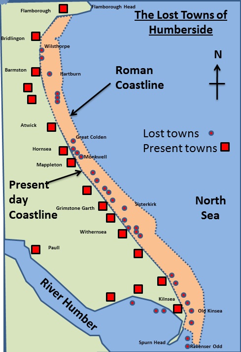
Key facts about Mappelton (Holderness coast)
342 people
50 homes
B142 road goes through village
How much was spent and what coastal defences were put in place at Mappelton?
£2 million in 1991
2 Rock groynes and rock armour
Granite for Norway create rock groynes
Cliff has been stabilised through landscaping and vegetation cover
How was Mappelton coastal protection successful?
Groynes have reduced erosion and a beach has built up, preventing more erosion
How was Mappelton coastal protection unsuccessful?
Further south the rate of erosion has significantly increased as no sediment is being replaced as it is all trapped by groynes in Mappelton
This means there is no beach to protect the cliff→increased erosion and slumping
Significant loss of land
Why do people say Mappelton should have used managed retreat?
Much cheaper
Does not harm places further down the coast
Allows salt marsh to form
Road could be moved which would prevent the need for sea defences in Mappelton in the future
What are some sustainable urban strategies?
Providing green spaces
Recycling water
Reducing reliance on fossil fuels
Involving local communities
Large range of employment
Conserving cultural, historic, environmental sites and buildings
Using Brownfield instead of greenfield sites
Reducing waste + Pollution
Where is Freiburg?
SW Germany near Switzerland + France. Near River Maulde
How has their been social planning in Freiburg?
- Local people can invest in renewable energy resources, e.g. in one district they have invested over £5 million in 9 windmills, 8 solar energy systems (one at the football stadium), a hydro-electric plant, and an energy conservation scheme at the local school.
- Investors gets free football field tickets + financial returns
- Financial rewards are given to people who compost their green waste and use textile nappies.
What is Freiburg’s ‘Solar Valley’
Cluster of solar companies
Solar Factory employs 250 people making solar panels
Solar Training centre
Hosts European solar energy conferences
10000 people employed in 1500 environmental businesses in city
1000 people employed in solar tech industry
Freiburg has…
More than __________ corks recycled each year
More than ___ of packing waste recycled
Provided energy for ______ homes from burning waste
1 million
88%
28,000
Freiburg has…
________ of non-recyclable waste
___community collection points for recycling
A _________ for organic food and garden waste which is collected weekly
90 kg per head ( Germany average is 122kg)
350
biogas digestor
Describe Vauban in Freiburg
Inner City district built on former army barracks
5500 people in low energy buildings
Green spaces
Green roofs - water storage
How does Freiburg use water sustainably?
Harvests rainwater
Promotes using water sparingly
Green roofs
Permeable pavements
Unpaved tramways
Drainage wetlands
River Dreisam managed using flood retention basins
What is Freiburg’s strict energy policy based on?
Energy Saving
Efficient Technology
Use of renewables
How many solar panel installations are there in Freiburg? How much energy do they produce?
400 installations - including Heliotrope which rotates to follow sun
10 million kilowatts per year - excess sold
Where does the majority of Freiburg’s renewable energy come from?
Biomass - waste wood + rapeseed oil
Enough energy to heat Freiburg’s 3 pools
How do green spaces benefit the economy and environment sustainably?
‘green lungs’ - keep the air clean
Soil protected and prevents runoff
Natural + free recreational resource + habitat for wildlife
How is waste recycling managed in Freiburg?
3 bins - paper, organic + garden waste (Bio bin), Non recyclables
Yellow sack for packaging
Bio bin collected 1x a week, rest every fortnight
Glass sorted by colour + disposed in community bins
Three permanent recycling yards in city
Recycled paper is used in school exercise books
Disposable drink containers are banned
Why is Freiburg known as the ‘green city’?
40% of city is forested
44,000 trees planted in parks + streets
Only native trees and plants planted in 600 hectares of plants
44% of wood from forests used for timber but 75% grows back in 1 year
56% of forests are nature conservation areas
River Dreisam is unmanaged
Risefield District - 78 hectares built on, 240 hectares open space
What is the most important part of Freiburg’s integrated transport system and why?
Trams
Efficient, cheap + accessible public transport
Low fares
Tickets for concert, sport event valid to use on public transport
70% of pop. live within 500m of tram stop
Trams every 8 mins
Tram network - 30km, connected to 168km of city bus routes
How many cycle paths and parking spaces for bikes are there in Freiburg?
400km of cycle paths
9000 parking spaces
Bike + ride facilities at railway + bus stations
How has Freiburg’s transport scheme changed the types of transport used?
Tram journeys increased by over 25,000 in 1 year
Car journeys reduced by 30,000
Due to limited space Singapore has high congestion, what measures has it introduced to combat this?
- Restricted entry to the city centre during rush hours
- Electronic road pricing on major roads
- Quota system to reduce the number of car owners
- High petrol prices
- High vehicle registration fees and strict requirements for obtaining a driving license
- Financial incentives for using cars only at weekends
- Government car-sharing schemes
- Development of an overhead railway system and efficient bus network
- Advanced electronic monitoring and control of traffic signals to keep traffic flowing
How have traffic policies improved congestion in Singapore?
-45% less traffic +25% fewer accidents in the city centre
-40% decrease of traffic on roads in city centre
- 2/3 of daily journeys use public transport
- car ownership declined by 1% since 2000.
How many cars does Beijing have?
5 million
What strategies have been introduced in Beijing to reduce traffic congestion?
Limiting car sales - only 20% who apply allowed as car
Increased parking fees. Congestion charge +pollution tax
Expansion of the public transport system. 30 new metro lines and a rapid bus transit system to be built by 2020. The metro currently serves only half of Beijing’s population.
Restrictions on vehicle use. Cars are banned from the city one day a week, based on a number plate system. Non-residents cannot bring a car into the city.
How have restrictions in Beijing improved traffic congestion?
20% drop in car use
12% drop in use of car parks in city centre
Building + widening roads has reduced cycling + increased car use
Bristol is the __________ in the south west of England
Largest
What is the Population of Bristol?
440 500
How is Bristol important?
Industry
Education
Religion
Culture + Entertainment
Tourism
Bristol is the Uk’s __ most popular city for foreign visitors
eighth
How is Bristol an important international city?
Good transport links → M4, good rail links. Easy access to London and ferry services to Europe
Bristol airport
Global industries - financial, defence, aerospace, technology , culture and media
Investment into manufacturing -e.g. airbus, BMW
Bristol University
How have migrants impacted population growth in Bristol?
2021 census - 18.8% of Bristol’s population was born outside of the UK
How has migrants impacted the cultural diversity of Bristol?
45 different religions
over 180 birth countries
90 distinct languages
Events like St Paul’s Carnival
How have migrants made economic contributions to Bristol?
Fill gaps in labour market, especially sectors such as healthcare, construction and hospitality
Where are most migrants from in Bristol?
Poland (6415)
Somalia (4947)
India (3809)
*2011 census
How has the population of Bristol changed?
Growing rapidly
Over 2 million people live within 59km of the city
How has the ethnic diversity of Bristol changed?
Becoming more ethnically diverse
How has the population composition of Bristol changed?
Large youthful population (due to Unis)
More people under 16 than pensionable aged people
How has the connectivity of Bristol changed?
Network of motorway, road rail and air connections
e.g. second river Severn crossing have made it more accessible
e.g. electrification of rail line to London
What are some key entertainment venues in Bristol?
Bristol Old Vic
Bristol Hippodrome
Tobacco Factory
Colston Hall
How has Bristol’ culture been influenced by change?
Youthful population - underground music scene, nightclubs + bars
Ethnically mixed population - e.g. St Paul’s Carnival
Diverse food choice e.g polish, Korean, Caribbean, Chinese
How is sport a social opportunity in Bristol?
Bristol Bears Rugby
Bristol city f.c
Bristol rovers - UWE stadium - large events, attractive facilities
Gloucestershire county cricket
Venues provide a range of leisure, conference facilities and accommodation. They are large attraction
How is shopping a social opportunity in Bristol?
Shopping is a growing leisure activity
There are developments to encourage people to shop in the CBD - theses include pedestrianisation, improved public transport, promoting tourism, open street markets, improving appearance
Improving shopping centres e.g Broadmead are needed crime, improve environment, attract employment, compete with other cities
What is Cabot Circus in Bristol?
Shopping centre
Opened in 2008
Cost £500 million
Shops, leisure facilities, offices, hotel with 25o apartments
How has Bristol’s harbourside been regenerated?
Former workshops and warehouses converted into bars, nightclubs + cultural venues
Art gallery, museum. media + arts centre
Harbourside festival→ 300,000 spectators
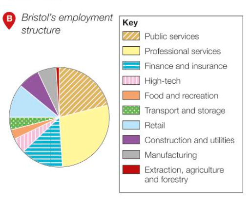
Describe Bristol’s employment structure and how it has changed
½ wok in public/professional services. Extraction + agriculture lowest employment sector. Most jobs are tertiary. wide range of job types
Increasing tertiary and quaternary sectors as many ports shut down
Why have high- tech industries developed in Bristol?
Close links between the council and university
advanced research at the university
Large educated + skilled workforce
Different industries work together in R&D
£100 mil grant to become a Super Connected City
How many micro electrons and silicon design businesses are in the Bristol area?
50
Largest concentration outside Silicon Valley
Who are Aardman Animations (Based in Bristol)
set up in 1972
in late 1990 enterred computer animation
well known for stop motion clay animation - e.g wallace & Grommit
Won Oscars and many other awards
What are the Defence Procurement Agency headquarters in Bristol?
Government policy to decentralise agencies from London
Established on greenfield site in 1996
Employs over 10,000 people
Supplies army, navy + air force
How did employment at the Defence Procurement agency in Bristol cause urban sprawl?
Increased employment = more housing
→ Bradley Stoke with population of 21,00 is an example of link between economic opportunities and urban change
How is aerospace important in Bristol?
14/15 main global aircraft companies found in Bristol e.g rolls Royce, airbus, gkn aerospace
Supply chains have grown in region to supply high tech companies
Filton enterprise area - cutting edged aviation tech hub
Word class aerospace courses at local universities
When did Bristol become the first European Green Capital in the UK?
2015
How many businesses created a ‘green action plan’ in the first year of Bristol as European Green Capital?
175
How many electric car charging points were installed in the city in the first year of Bristol as European Green Capital?
100
How does Bristol’s Green Capital (2015) aim to create environmental opportunities?
Improve energy efficiency - reduce energy use by 30% + Co2 emissions by 40% by 2020
Increase the use of renewable energy from 2% (2012)
Reduce water pollution by improved monitoring and maintenance
Establish an Air Quality Management plan to monitor air pollution
Increase the use of brownfield sites for new businesses and housing
Environmental awareness programs
Primary students planting trees
What year was Bristol the UK’s 2nd most congested city?
2012
rush hour journeys took 1/3 longer than at other times of day
What percentage of Bristol’s population walk or cycle and how many more cyclists do they aim for by 2020?
57%
Aim to double number of cyclists by 2020
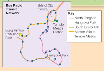
What is the Rapid Transit Network in Bristol and what does it aim to do?
3 bus routes linking Temple Mead station with Park and Ride sites
Network construction began in 2015 and first started operating in 2018
What does the Integrated Transport System in Bristol aim to achieve?
Link different transport systems together
Improve accessibility in the area
Reduce transport congestion
Reduce transport costs - city industries have more profit
Increase employment opportunities
Makes journeys smoother
Encourage use of public transport
More sustainable transport
What rail improvements are planned for Bristol and what do they aim to do?
Electrification of line to London
Greener transport,
More reliable journeys
Improved connections across SE England + S Wales
How much of Bristol is open space and how many people live within 350m of waterways/ parkland?
1/3 is open space
90% within 350m of open space
How many nature reserves and parks are there in Bristol city?
8 Nature reserves
300 Parks
What are some green initiatives and examples of urban greening in Bristol? How have they provided environmental opportunities?
Queen Square - Dual carriageway converted into open space with cycle routes
Sites of Nature Conservation Interest (SNCI) raised to top conservation condition by 2026
2&% of city to be part of wildlife network
Wildlife objectives in non- natural habitats e.g cemeteries
30% of city to be covered by trees
Housing Development in Portbury Wharf has neighbouring nature reserve
Open water + meadow create invaluable habitats
How is Bristol Environmentally challenged?
Many industrial derelict buildings
Large urban sprawl into rural areas
Where are the areas of Dereliction in Bristol?
Inner city where there are many redundant industrial buildings
When Port moved downstream many warehouses left to decay
Where is Stokes Croft, how is it environmentally challenged and what is being done to improve the area?
High density housing built in 19th century for industrial workers
Many derelict + abandoned properties
Squatters - riots + antisocial behaviour
Bristol City Council got lottery grants to improve economy and environmental decay in area
Area revitalised through public art + community action
How has urban growth caused urban sprawl in Bristol?
Increasing demand to live in suburbs + green areas on outskirts
Good transport links for commuting
Increasing population - jobs, university
Urban Sprawl is most significant ion the North West e.g Bradley Stoke
What is being done to reduce urban sprawl in Bristol?
Developing brownfield sites
2006-2013 6% of new housing on greenfield land
by 2026 300,000 homes planned on Brownfield sites
What are the advantages and disadvantages of developing on Brownfield sites?
Revitalisation of urban areas
Existing infrastructure
Proximity to employment
Higher costs
Pollution
Limited design flexibility
What are the advantages and disadvantages of developing on Greenfield sites?
Cheaper + faster development
Healthier environment
Design Flexibility
Loss of Natural Habitats
Increased Urban Sprawl
Environmental Impact
The amount of waste produced per head in Bristol is _____________ than the UK average
23% lower
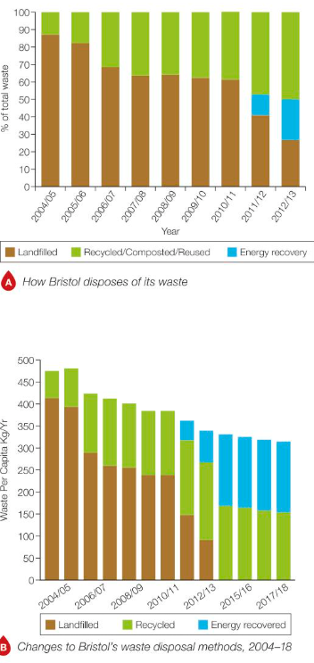
How much waste does Bristol produce a year and how much is recycled?
Over ½ million tonnes
Top English city recycler
About ½ of waste is not recylced
How is Bristol reducing the environmental impact of waste disposal?
Reduce amount of waste sent to landfill
Recue waste pr household by 15%
Increasing waste recycling to 50%
Higher targets with contractors who handle household waste
Educating on recycling
Kerbside collections + facilities for different types of recycling
Technological improvements in Recycling
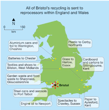
Where is Bristol’s recycled material sent to be reprocessed?
Across England + Wales - generates income
e.g :
Batteries→ Cheshire
Glass→ Harlow, Essex
Engine Oil → Newport
Paper → Aylesford Kent
How much waste does the Avonmouth waste treatment plant treat a year and what is it used for?
200,000 tonnes per year
Non recyclable waste used to generate enough electricity to power 25,000 homes in Bristol
How many people die per year due to air pollution in Bristol and how?
200 per year
Prevailing winds from SW blow pollutants over city from industrial area around Avonmouth port
How is Bristol’s air quality being improved?
Reduced speed limit on motorways near residential areas
From Gateway - walking + cycling route to city centre
Public transport app
EV programme
What is Bristol’s eco friendly ‘poo bus’?
Britain’s first bus to be powered by human + food waste
Between Bath + Bristol Airport
Runs on biomethane produced at sewage treatment works
300km range - annual waste of 5 people
Describe Filwood in Bristol
Socially deprived = top 10% in country
Low income households
Bullying, crime, drug use, poor environment
Describe Stoke Bishop in Bristol
Affluent suburb in NW of Bristol
Many millionaires in Sneyd Park
Overlooks Clifton Downs + River Avon
Compare Housing in Filwood + Stoke Bishop in Bristol
Filwood
Council houses from 1930s+40s poorly insulated- built to replace slums
6% of houses overcrowded
4% Detached houses
Stoke Bishop
80% of housing is owner occupied
>2% of houses overcrowded
Inadequate parking
28% Dethatched houses
Compare Education in Filwood + Stoke Bishop in Bristol
Filwood
35% of pupils have free school meals
2013 -36% of students got top grades at GCSE
Stoke Bishop
14% of pupils have free school meals
½ population has a degree or equivalent
94% of students got highest grades in 5 / more GCSEs
Compare Health in Filwood + Stoke Bishop in Bristol
Filwood
Life Expectancy 3 years below city average
Lowest participation in Sport + Creative activities in city
Poor access to fresh fruit + veg for healthy diet
High levels of obesity + smoking
Stoke Bishop
Life Expectnacy 4 years above city average
90% of population in good health
½ population play sport al least once a week
Compare Employment in Filwood + Stoke Bishop in Bristol
Filwood
1/3 of people aged 16-24 unemployed- ½ long-term unemployed or have never worked
¼ of children live in low income family
Stoke Bishop
2% of population is unemployed
>3% of children live in poverty
What is the Bristol + Bath Green Belt?
Set up to prevent urban sprawl on urban fringe + merging of Bath + Bristol
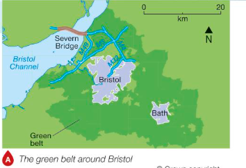
How have the South Gloucestershire authorities developed land North of the Bristol City?
Bradley stoke built in late 1980s
Harry stoke - 1200 homes built, 2000 homes planned for 2016-17
Why are people concerned about Harry stoke development in Bristol?
Increased congestion, noise, pollution
Loss of habitas
Loss of open space
Impact on existing community services
Increased local flood risk
Between 2006 and 2013, Bristol built ____ of new housing on ________ sites
94%
Brownfield
Includes using former office buildings, pubs, factories, dockyards, listed buildings and coach depots