APHG unit 6 exam
1/29
There's no tags or description
Looks like no tags are added yet.
Name | Mastery | Learn | Test | Matching | Spaced | Call with Kai |
|---|
No analytics yet
Send a link to your students to track their progress
30 Terms
In the development of urban land, which of the following is typically built on the most accessible sites?
Single-family housing
Farm markets
Retail complexes
Industrial parks
High-rise apartment buildings
Retail complexes
According to central place theory, the threshold is defined as the
economic base of a central place
distance away from a central place
gross value of the product minus the costs of production
minimum number of people needed to support a service
point at which consumer movement is at a minimum
minimum number of people needed to support a service
Which of the following best explains why New York City has more specialized stores than do smaller urban places in the United States?
Its status as a primate city
The rank-size rule
The gravity model
Central place theory
The Burgess concentric zone model
Central place theory
In the fundamentals of central place theory, which of the following terms is defined as the maximum distance a consumer will travel to acquire a good or service?
Distance decay
Threshold
Cost-to-distance ratio
Relative location
Range
Range
An urban center that is disproportionately larger than the second largest city in a country and that dominates the country's social, political, and economic activities can be best classified as
a megalopolis
a conurbation
a primate city
an edge city
an imperial city
a primate city
As old central business districts and industrial zones in more developed countries lost businesses and employment in the mid- to late twentieth century, suburban development expanded. Which of the following types of cities resulted from rapid suburban growth and the expansion of retail areas, office developments, business centers, and corporate headquarters to provide jobs and services in suburban areas?
Megalopolises
Financial districts
State capitals
Edge cities
Manufacturing zones
Edge cities
Although gentrification can revitalize cities by rehabilitating residential areas, which of the following problems can be explained by the type of building renovations shown in the before and after images?
More parking leading to decreased public transportation use
Higher rents causing displacement of existing residents
New buildings causing environmental sustainability issues
Disuse changing areas into zones of abandonment
Unfair real estate practices resulting in housing and insurance discrimination cases
Higher rents causing displacement of existing residents
Which of the following is a general theory in geography that can be used to quantify and predict the interaction between two cities based on population sizes, distance between the places, the number of migrants moving from one place to the other, or the flow of trade goods between the two locations?
Central place theory
World system theory
Concentric zone model
Multiple nuclei model
Gravity model
Gravity model
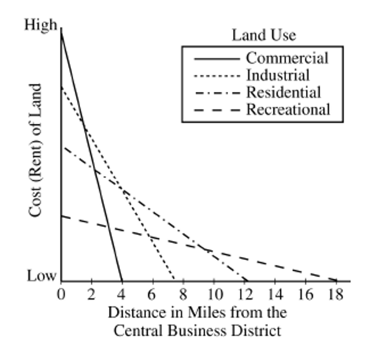
Which of the following best explains what the concentric zone model and bid-rent curve illustrate about patterns of urban areas?
Together they show how housing prices rise exponentially in rural areas.
Together they show how land prices rise exponentially closer to the central business district.
Together they show how rents for apartments drop precipitously closer to the central business district.
Together they show how rents for agricultural land rise exponentially farther from cities.
Together they show how rents for commercial office space rise exponentially on the urban periphery.
Together they show how land prices rise exponentially closer to the central business district.
Many medium-sized metropolitan areas such as Minneapolis-Saint Paul, Minnesota, or Charlotte, North Carolina, have added light-rail train systems to their public-transit networks. Which of the following best explains the goals of light-rail projects?
Reduce highway accident numbers due to unsafe driving and outdated, less-safe vehicles
Protect wetlands and local lakes from water pollution caused by industrial waste discharge
Reduce the ecological footprint of cities and reduce the air pollution created by vehicle exhaust
Redevelop urban brownfields and promote farmland protection policies that reduce urban sprawl
Plan for sustainable residential zoning and establish an urban-growth boundary around cities
Reduce the ecological footprint of cities and reduce the air pollution created by vehicle exhaust
In the new global economy, an increasing proportion of influential financial decisions are being made in
the informal sector
regional centers and small towns where fax machines are used
the field, close to the sources of agricultural production
national capitals because of the increasing importance of the nation state
major corporate centers such as New York, London, and Tokyo
major corporate centers such as New York, London, and Tokyo
Mixed-use development, pedestrian-friendly design, and the incorporation of front porches and alleys are design elements of which of the following?
New urbanism
Transit-oriented development
Zero growth
Urban growth boundaries
Leapfrog development
New urbanism
Which of the following accurately describes the city population data in the table?
Bangkok is both a metacity and a primate city.
Hanoi is both a world city and a primate city.
Ho Chi Minh City is both a megacity and a primate city.
Hanoi is both a capital city and a primate city.
Bangkok is both a megacity and a primate city.
Bangkok is both a megacity and a primate city.
According to the rank-size rule, if the largest city in a region has a population size of 900,000, then the third largest city will have a population of
3,000
9,000
45,000
300,000
900,000
300,000
Which of the following was NOT a reason for rapid suburbanization in the United States after the Second World War?
Mass production of the automobile
Reduction in long-distance commuting
Expansion of home construction
Expansion of the interstate highway system
Availability of low down payment terms and long-term mortgages
Reduction in long-distance commuting
Using the diagram above, at what distance from the central business district will recreational land use begin to outbid all other land uses?
About 3 miles
About 6 miles
About 10 miles
About 12 miles
About 18 miles
About 10 miles
According to Christaller's central place model, which of the following would most likely have the smallest range?
A university
An international airport
A grocery store
A professional football stadium
A symphony orchestra hall
A grocery store
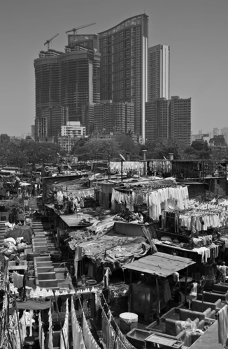
As migrants from rural areas continue to move to cities for jobs, cities face a variety of economic and social challenges. Which of the following economic or social challenges is best illustrated by the photograph shown of Mumbai, India?
The city's infrastructure cannot support the high population density in the central business district.
A large number of unemployed people live in the city.
There is a significant income gap between residents on the periphery of the city and residents in the city center.
The city's economic status in the global market is declining.
There is a high level of homelessness in the city's central business district.
There is a significant income gap between residents on the periphery of the city and residents in the city center.
Transit-oriented development in Southeast Asian cities is an innovative strategy to minimize crippling traffic jams. One aspect of transit-oriented development is the use of dedicated rapid-transit bus lanes to more efficiently connect residential neighborhoods with activity nodes. An added benefit of this strategy that would appeal to advocates of sustainable city-development programs is the
lowering of fertility rates
stimulation of urban sprawl
influx of rural-to-urban migrants
increase in profits for bus operators
reduction in carbon emissions
reduction in carbon emissions
Which of the following exemplifies a smart-growth approach to urban planning?
Construction of wider highways in an effort to lessen congestion
Conversion of farmland to housing to encourage migration to suburbs
Creation of zoning laws that separate retail space from housing developments
Creation of walkable neighborhoods with mixed-use land and access to public transportation
Construction of affordable housing in suburban neighborhoods
Creation of walkable neighborhoods with mixed-use land and access to public transportation
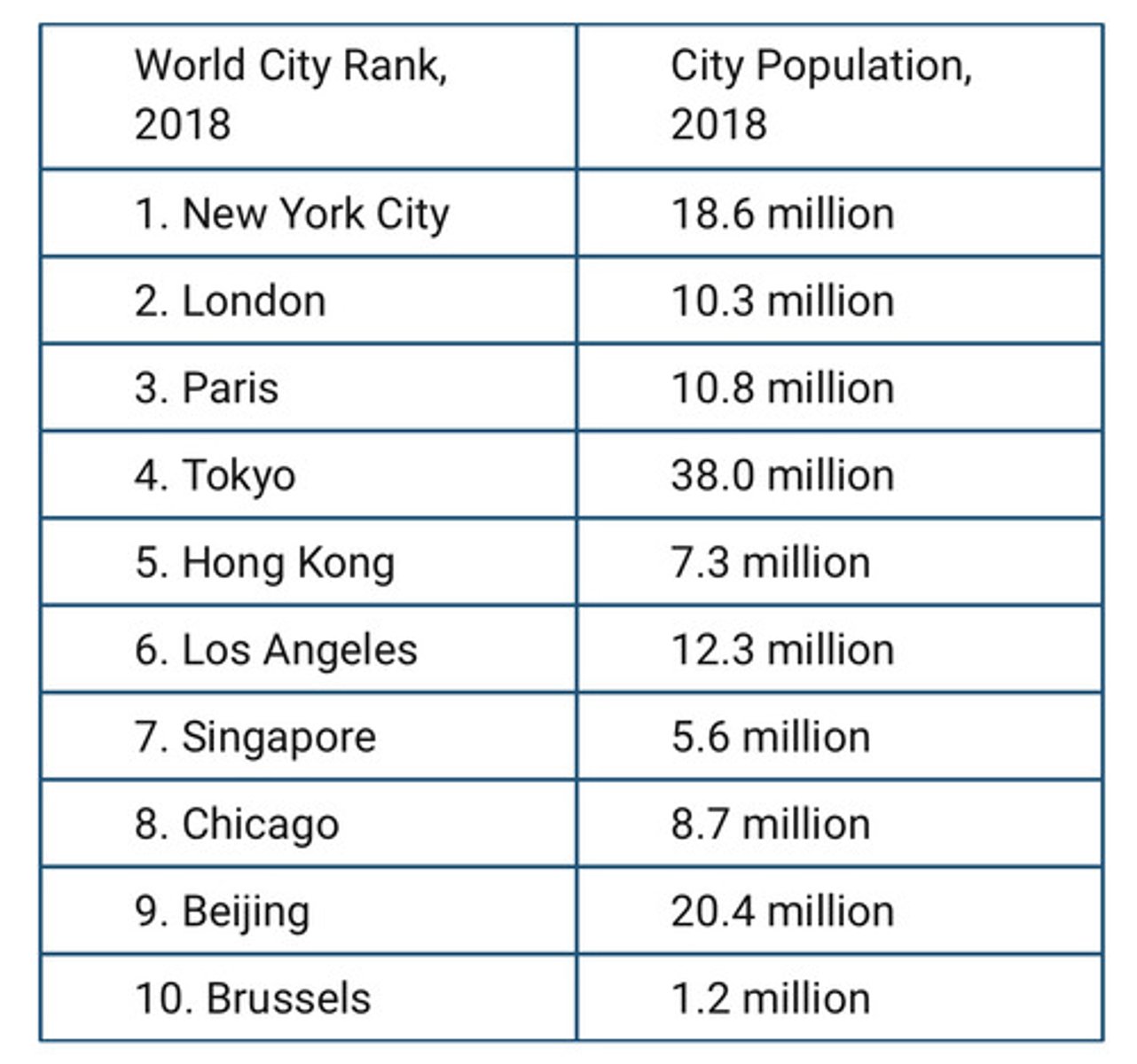
Which of the following statements best explains how the world cities listed in the table function within the world's urban hierarchy?
The top ten world cities have a significant impact on the international economy and are important drivers of globalization.
The cities with larger populations are the biggest drivers of global innovation.
The cities with smaller populations can be expected to experience the fastest rates of population growth within the next several decades.
The top ten world cities offer a wide array of services, but these services are restricted to local populations.
The top ten world cities are diminishing in financial and cultural significance due to the process of globalization.
The top ten world cities have a significant impact on the international economy and are important drivers of globalization.
Which of the following best illustrates how the world cities in the table are connected globally in ways that transcend national borders?
Tokyo developing into one of the largest megacities
London building a new financial district
London and Tokyo being seats of national governments
New York City and Tokyo being located in coastal environments
Chinatown and the United Nations being located in New York City
Chinatown and the United Nations being located in New York City
The galactic city model was developed in response to the growth of suburbs and the need for a more complex model than the sector and concentric zone models. Which of the following is a strength of the galactic city model?
It depicts exurban nodes.
It depicts a central business district.
It depicts early-twentieth-century industrial cities.
It is based on the location of an international airport.
It is based on the decrease of urban sprawl.
It depicts exurban nodes.
According to the rank-size rule, which of the following is typically true of higher-order services, such as hospitals with a large number of medical specialties?
They are located in suburbs.
They are located in small towns.
They have smaller ranges and thresholds.
They have larger ranges and thresholds.
They have larger ranges and smaller thresholds.
They have larger ranges and thresholds.
Which of the following statements explains the characteristics of cities in a postindustrial economy?
The postindustrial city has new structures since the buildings of the industrial city cannot be reused.
The postindustrial city has a large share of offices housing technology and information services.
The postindustrial city has very few companies in the manufacturing sector.
The postindustrial city is a high-density, compact city to facilitate information and technology businesses.
The postindustrial city has few low-skill or general service jobs because of the demands of technology industries.
The postindustrial city has a large share of offices housing technology and information services.
The multiple-nuclei model of city structure tends to be most applicable to
small cities
traditional cities
Latin American cities
newer, fast-growing cities
cities with homogeneous land use
newer, fast-growing cities
Which of the following is a correct statement about the major cities of the world?
Most are located on rivers or seacoasts.
Most are found in areas that are not very suitable for agriculture.
Most primate cities are located in the United States and western Europe.
They are concentrated between the tropic of Cancer and the tropic of Capricorn.
The world's fastest-growing cities are found in areas with the highest standards of living.
Most are located on rivers or seacoasts.
Which of the following is a true statement about classic models of city structure?
The concentric zone model does not have a transitional area.
The sector model is highly influenced by transportation patterns.
The central business district has the most dominant position in the multiple nuclei model.
The multiple nuclei model and the sector model are similar in that they both have only one core.
The interaction between the central city and the suburbs is greatest in the urban realm model.
The sector model is highly influenced by transportation patterns.
Compare the largest urbanized-area populations for each country, and then select the following statement that correctly draws a conclusion regarding the pattern in the data.
China has a primate city, and the United States follows the rank-size rule.
Neither country follows the rank-size rule.
The United States is closer to following rank-size rule.
Both countries have a primate city.
The United States has a primate city, and China follows the rank-size rule.
The United States is closer to following rank-size rule.
Central place theory describes the
spatial patterns of urban and outlying areas based on the flow of goods and services
tendency of different ethnic groups to congregate in a single location
tendency of civilizations to form around certain natural features
outward radiation of cultural patterns from a central place
tendency of wealth to concentrate in urban core areas
spatial patterns of urban and outlying areas based on the flow of goods and services