geography exam
0.0(0)
Card Sorting
1/132
There's no tags or description
Looks like no tags are added yet.
Last updated 11:55 PM on 6/14/23
Name | Mastery | Learn | Test | Matching | Spaced | Call with Kai |
|---|
No analytics yet
Send a link to your students to track their progress
133 Terms
1
New cards
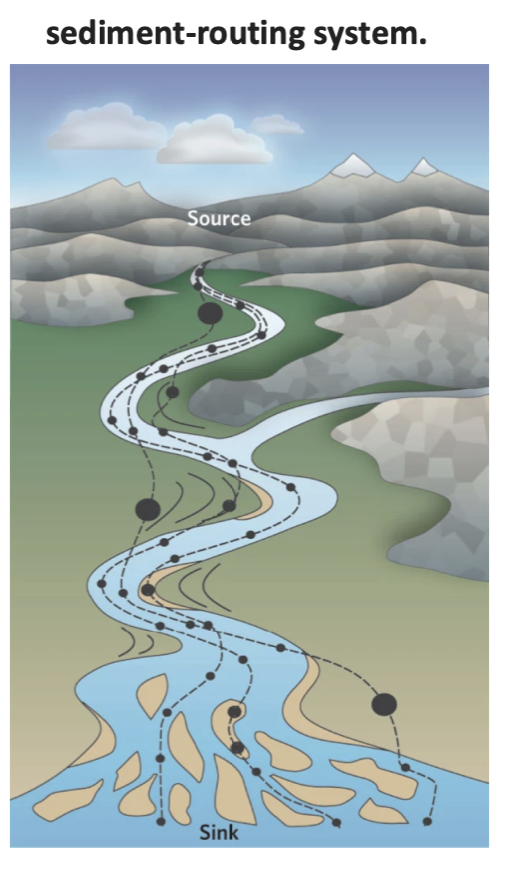
sediment routing
Sediment is transferred from source to sink along trajectories. (dashed lines)
Same trajectories involve short transit times with brief periods of storage ( small cirlces on river bed)
Whereas, others involve long transit times with long periods of storage (larger circles on floodplain)
Sediment routing is the relationship between transport and storage
Same trajectories involve short transit times with brief periods of storage ( small cirlces on river bed)
Whereas, others involve long transit times with long periods of storage (larger circles on floodplain)
Sediment routing is the relationship between transport and storage
2
New cards
example of people interrupting the sediment routing cycle
3
New cards
sediment routing reading
erosion depends strongly on climatic factors such as wind, temperature and rain exogenic (plus tectonic activity, endogenic)
sediment is transformed, phase-shifted and lagged by the internal dynamics of the routing system
local processes: sediment accumulation is controlled by local hydraulic variables, the range of sediment available and the details of the local topography of the channel, bars, banks and flood plain.
longterm= subsidence and tectonic activity
Mountains disturb atmospheric circulation that can influence climate such as some areas getting more rain than others. Changes in the amount of precipitation can influence erosion.
erosion occurring over an active tectonic plate that occurs within the crust and ends up changing the earth’s surface can cause a flow of rocks towards the surface of the basin.
tectonic folds are expanding and being eroded (then can cause earthquakes).
4
New cards
sediment budget
20 billion tonnes of particulate sediment is delivered to the ocean every year
5
New cards
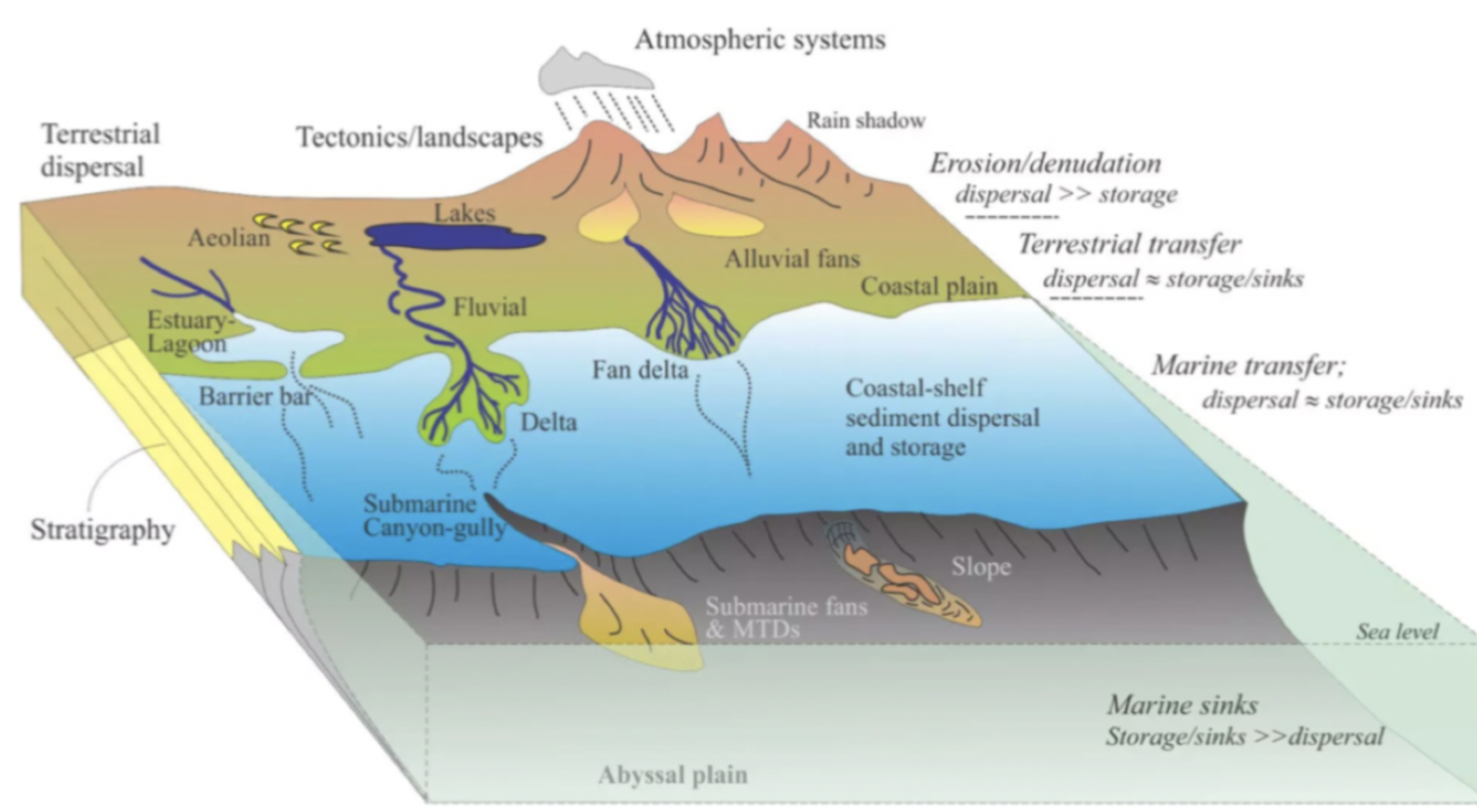
diagram to draw
6
New cards
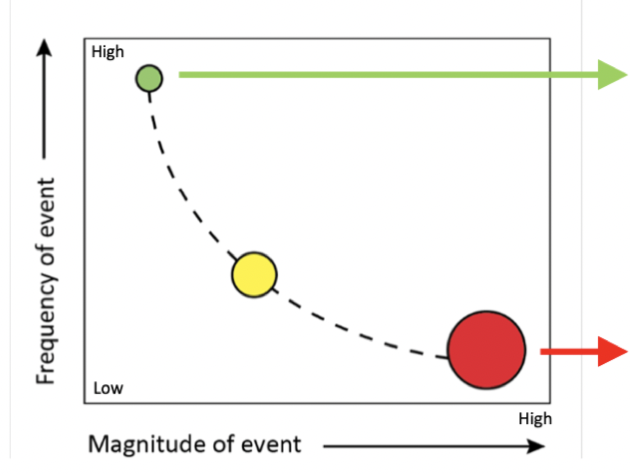
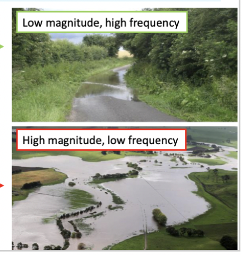
magnitude
the intensity of different events
high magnitude events tend to be low frequency
high magnitude events tend to be low frequency
7
New cards
frequency
how often something occurs
8
New cards
magnitude and frequency
can be used to predict natural hazards such as storms and floods
need a long duration of records to predict accurately- better freq and mag relationships
if we didn’t know the data historically, may think that the big floods that have happened recently have been the biggest flood with the highest magnitude. not accounting for bigger floods that could have occurred in the past. - will change the output of data
need to account for climate change
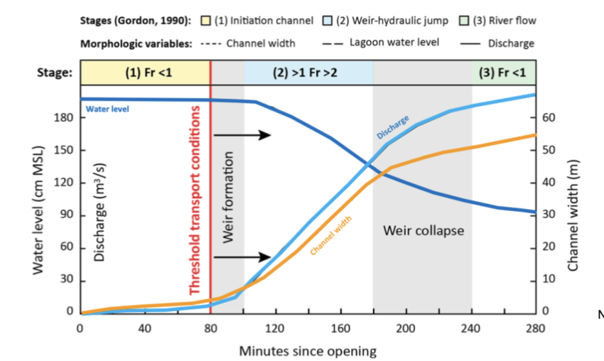
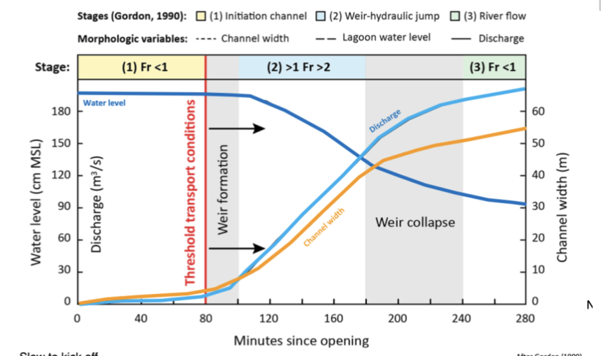
Intermediate magnitude-frequency events generally dominate fluvial sediment transport- more work done
only using the max- could be a smaller flood in the future that is larger than the previous maximum
need a long duration of records to predict accurately- better freq and mag relationships
if we didn’t know the data historically, may think that the big floods that have happened recently have been the biggest flood with the highest magnitude. not accounting for bigger floods that could have occurred in the past. - will change the output of data
need to account for climate change
Intermediate magnitude-frequency events generally dominate fluvial sediment transport- more work done
only using the max- could be a smaller flood in the future that is larger than the previous maximum
9
New cards
hillslope
Sides of valleys and the margins of eroding uplands
varying degrees of slopes and angles
material is loosened by weathering and then transported down slope to a river channel via exogenic processes and gravity
varying degrees of slopes and angles
material is loosened by weathering and then transported down slope to a river channel via exogenic processes and gravity
10
New cards
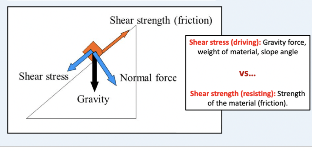
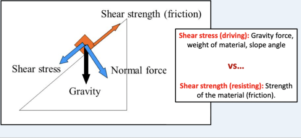
controls on slope instability
Determined by the balance of shear stress ( driving force of failure, gravity)
And shear strength 9resisting force, friction holding material on hillslope)
factor of safety: >1 no fail,
And shear strength 9resisting force, friction holding material on hillslope)
factor of safety: >1 no fail,
11
New cards
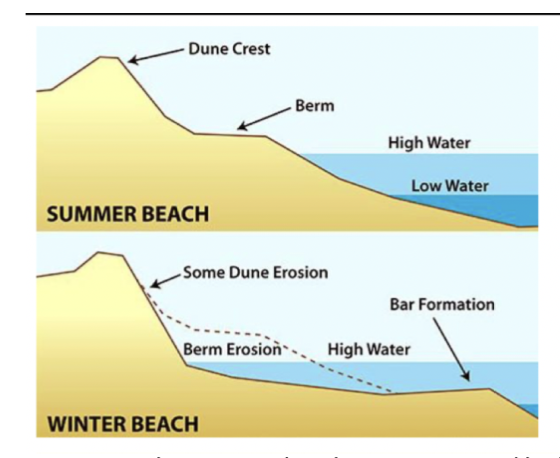
driver of instability: Relief
Higher elevation is more potential energy of force for something to move down the hill
angle of repose: Steepest angle, relative to the horizontal plane at which material can pile up without falling
Can change with material type
angle of repose: Steepest angle, relative to the horizontal plane at which material can pile up without falling
Can change with material type
12
New cards
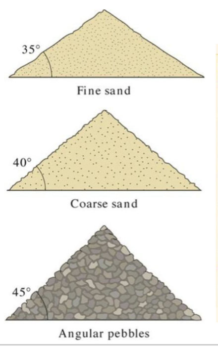
driver of instability: grain size
For dry material the angle of repose increases with grain size, (30-37 deg)
Fine sand: lower angle as less friction between
Angular pebbles: Material is ore spaced out and can stack ontop
Fine sand: lower angle as less friction between
Angular pebbles: Material is ore spaced out and can stack ontop
13
New cards
driver of instability: water content
water increases cohesion of soil grains via surface tension. Thin film of water that covers sand grains and enables them to stick together= Makes slopes more stable
If the sand gets too wet it can flow like a fluid, water also adds weight to slopes so water will fill the gaps in the soil and push the air out. High rainfall events= trigger slope failure
If the sand gets too wet it can flow like a fluid, water also adds weight to slopes so water will fill the gaps in the soil and push the air out. High rainfall events= trigger slope failure
14
New cards
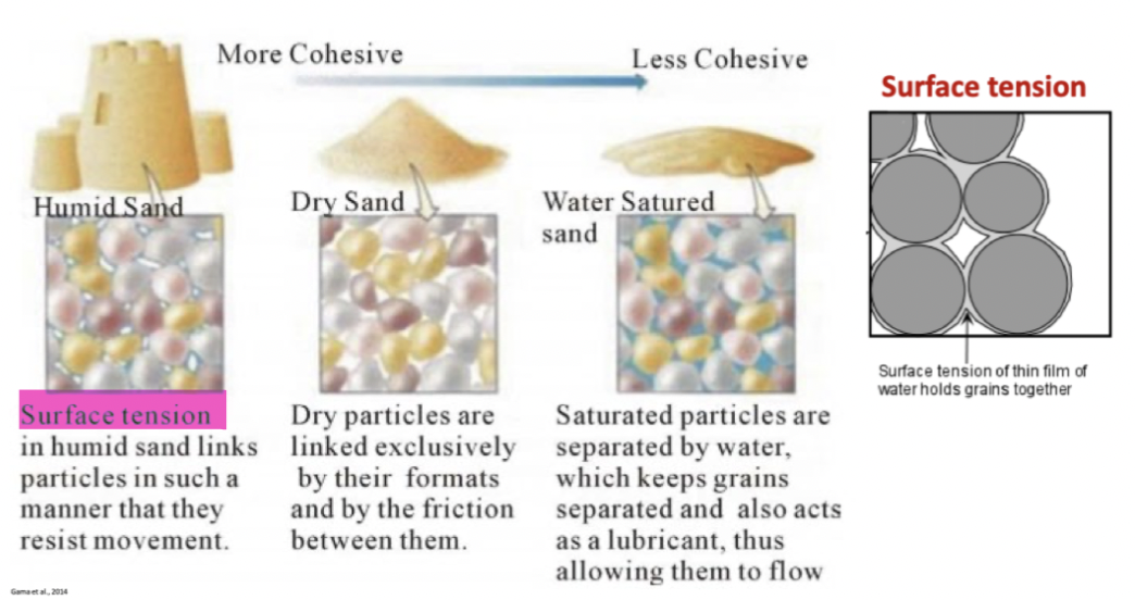
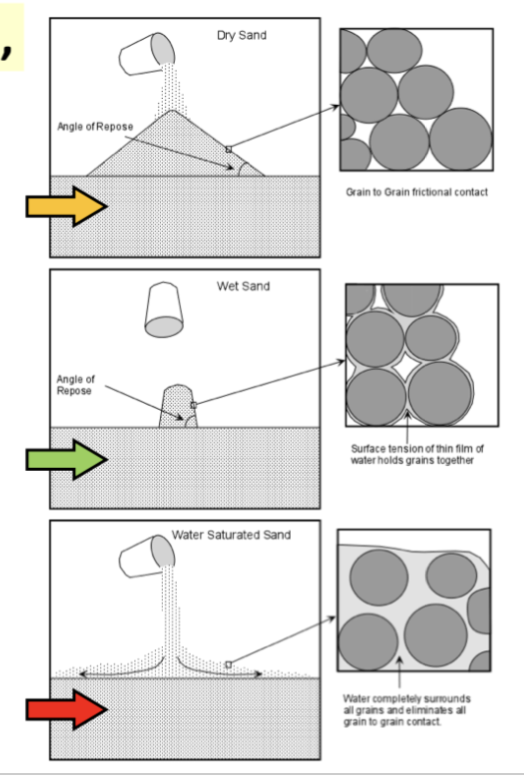
Dry unconsolidated, slightly wet and saturated material
dry unconsolidated: Form a pile with the slope angle determined by the angle of repose, there is grain to grain frictional contact
Slightly wet: high angle of repose, surface tension holds the grains in place, good cohesion
saturated: Low angle of repose, flows like a fluid. Water between the grains removed grain to grain frictional contact
Slightly wet: high angle of repose, surface tension holds the grains in place, good cohesion
saturated: Low angle of repose, flows like a fluid. Water between the grains removed grain to grain frictional contact
15
New cards
driver of instability: Vegetation
Roots will stabilize the soil so hold hillslopes in place and will intercept raindrop erosion
The excess weight of the soil and trees and added wind force
windthrow- Trees on hillslope when strong winds, roots connected to the soil so will dislodge soil up with the tree as it falls on its side
people removing vegetation promotes slope instability- Material (slash) gets pushed down into rivers which can cause issues for farmers etc.
16
New cards
driver of instability: fire
Fire can cause hydrophobic soils ( waxy oil layer above the soil) ash and organic material that has been burnt, and doesn’t allow water to go below the soil layer. Slopes fail as water cant infiltrate into the ground
17
New cards
driver of instability: geology
Weaker rocks or soils, such as loose sands, clays, or weathered materials, are more prone to slope failure than stronger rocks
Weak spots- faults, joints, fractures and cracks which can weaken the material
* water can get into the cracks and start to weaken the material
bedding slope
least stable- bedding of slope is parallel to the slope= unstable if stuff was moving down it it will shear off big chunks
Weak spots- faults, joints, fractures and cracks which can weaken the material
* water can get into the cracks and start to weaken the material
bedding slope
least stable- bedding of slope is parallel to the slope= unstable if stuff was moving down it it will shear off big chunks
18
New cards
driver of instability: earthquakes
seismic movements triggers mass movement such as landslides
this can create landslide dams, had seismic shaking, destabilising material on hillslope moved from a source area down the slope and accumulated in a river channel and blocked off the river and creates a lake. - risk that water can overspill
\
this can create landslide dams, had seismic shaking, destabilising material on hillslope moved from a source area down the slope and accumulated in a river channel and blocked off the river and creates a lake. - risk that water can overspill
\
19
New cards
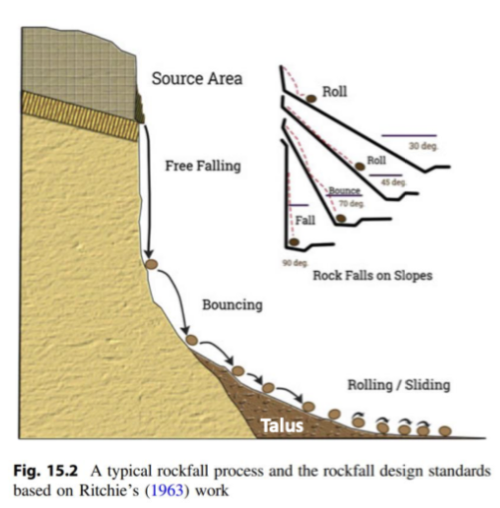
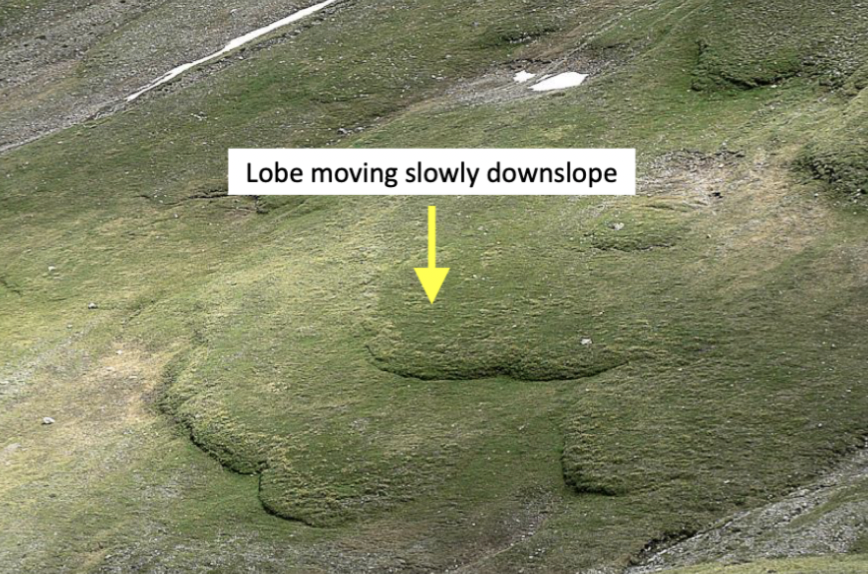
Mass movement: falls
Material detaches from a steep slope and free falls through the air
Fast movement which occurs of steep hillslopes/cliffs
Is triggered by earthquakes or erosional processes
Type of material= rock
Glacier retreating= increase in rockfall, not there any longer to support the walls back, as ice melts and ice creeps backwards the wall relax= rockfall
Fast movement which occurs of steep hillslopes/cliffs
Is triggered by earthquakes or erosional processes
Type of material= rock
Glacier retreating= increase in rockfall, not there any longer to support the walls back, as ice melts and ice creeps backwards the wall relax= rockfall
20
New cards
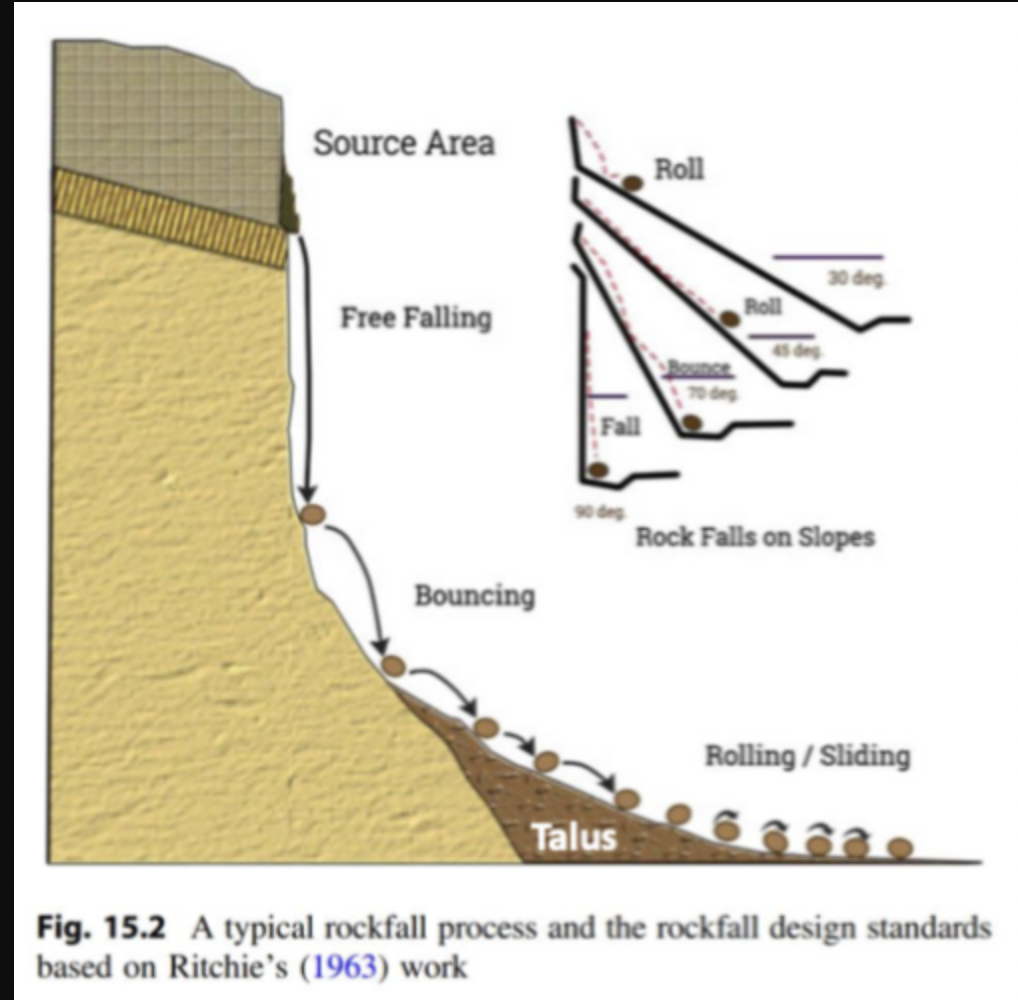
Mass movement: falls diagram
21
New cards
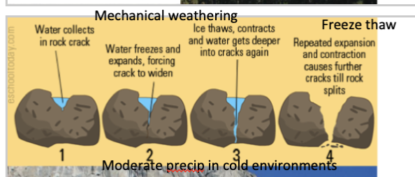
mechanical weathering
Water collects in a crack in a rock
Water will freeze and then expand, causing the crack to widen
Ice thaws then water contracts are gets deeper into the cracks
Repeated expansion and contraction causes further cracks till the rock splits
Moderate precipitation in cold environments, with seasonal variability
Water will freeze and then expand, causing the crack to widen
Ice thaws then water contracts are gets deeper into the cracks
Repeated expansion and contraction causes further cracks till the rock splits
Moderate precipitation in cold environments, with seasonal variability
22
New cards
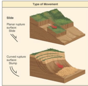
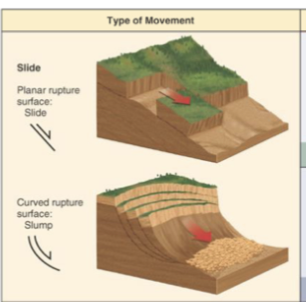
Mass movement: slides
Zone of weakness separates the material from the stable underlying material (moves as blocks), movement is parallel to slope, variable speeds
Slide: translational, will move along a planar surface
Slump: rotational, surface of rupture is curved concavely upward
Slide: translational, will move along a planar surface
Slump: rotational, surface of rupture is curved concavely upward
23
New cards
Mass movement: slides and slumps diagram
24
New cards
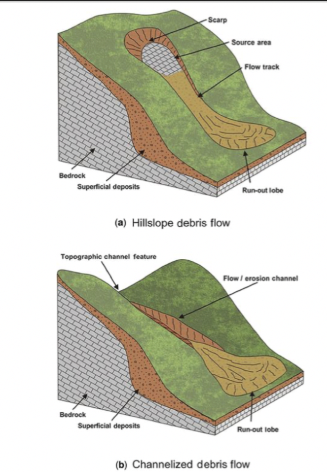
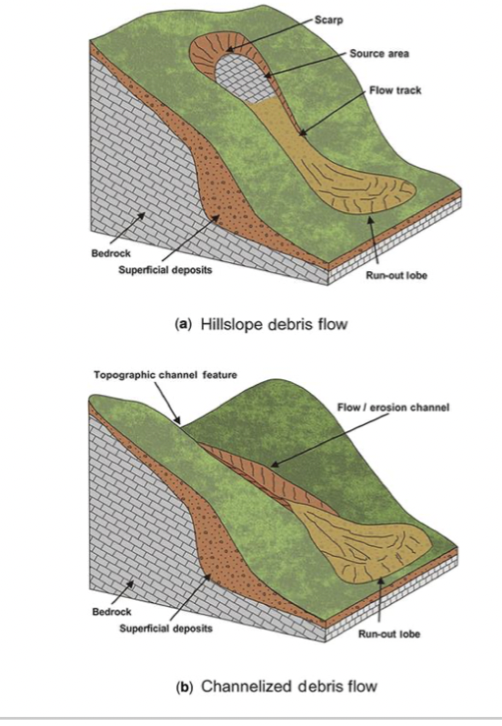
Mass movement: flows
Moves downslope as a fluid (mud, debris, or earth), due to being saturated (high water content) and usually a mix of grain sizes
Rapid rate of movement , hazardous
Follow river channels and occur after heavy rain, common after fires
Mix of material, rocks, trees, sand, mud, debris
Rapid rate of movement , hazardous
Follow river channels and occur after heavy rain, common after fires
Mix of material, rocks, trees, sand, mud, debris
25
New cards
Mass movement: flows diagram
26
New cards
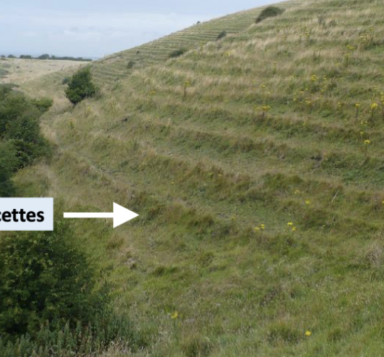
Mass movement: soil creep
Slow downward progression of material on low-grade slopes
common in humid and temperate climates. (seasonal changes in soil temp and moisture)
Due to the upward movement of an underlying soil layer due to the wetting and drying cycles, filling of cracks from upslope.
form terracettes
Tree trunks bend as the material moves from underneath it
27
New cards
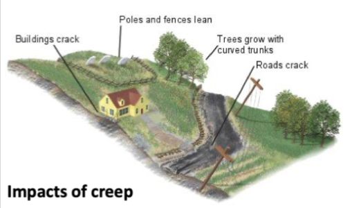
Mass movement: soil creep diagram
28
New cards
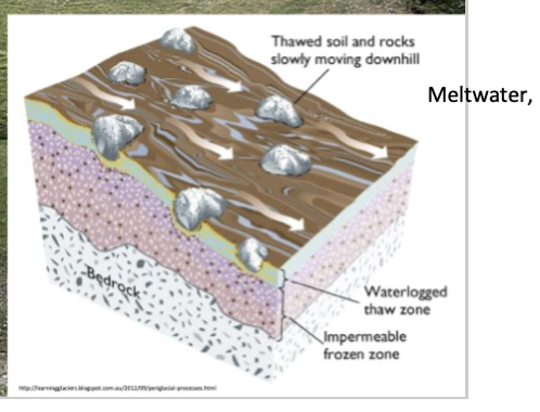
Mass movement: solifluction
Gradual movement f water-saturated soil over frozen ground (permafrost) that acts as a sliding plane, downslope
It occurs in the summer in a periglacial environment
\
It occurs in the summer in a periglacial environment
\
29
New cards
Mass movement: solifluction diagram
30
New cards
Lahars
Violent mud/debris flow composed of a slurry of pyroclastic material, rocky debris and water
Material flows down from a volcano typically along a river valley
Destructive, mix grain size
Water picks up material and moves it off the slopes of the volcano
Hot: requires volcanic eruption, Snow/ice melted by volcano, Heavy precipitation during eruptions
Cold: no elevated temp, due to heavy precipitation or a snow melt event that mobilize loose volcanic deposits.
31
New cards
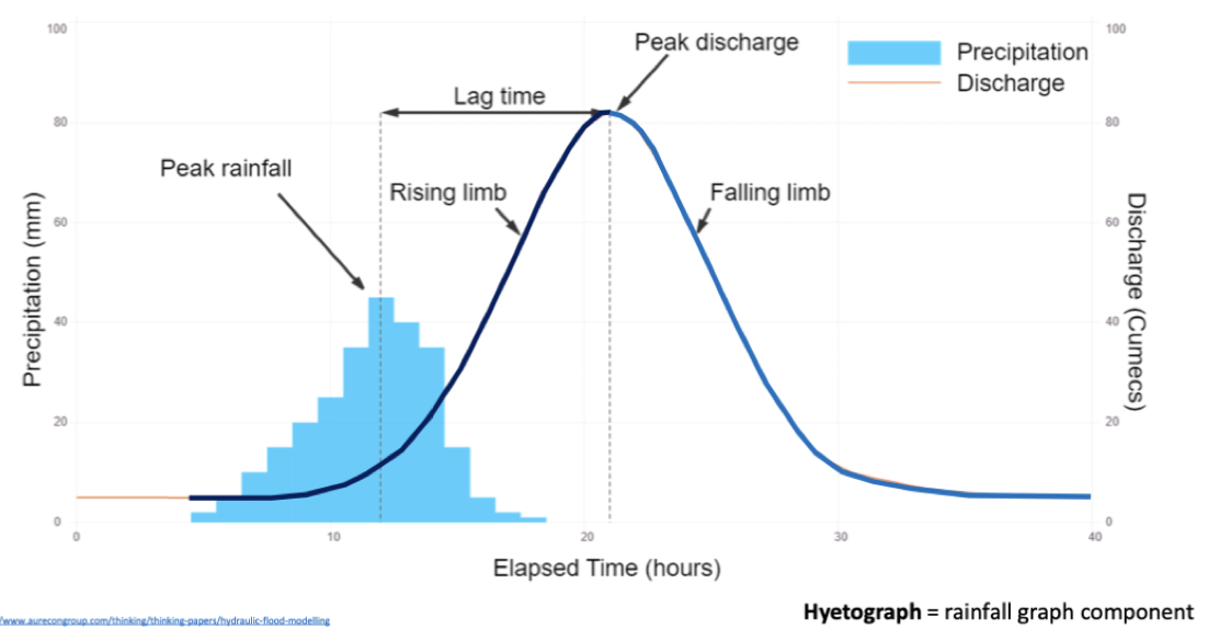
flood hydrographs
How drainage basin responds to rainfall
Flood planning (predicting time/magnitude)
Show the river discharge that occurs as a result of precipitation from a storm
Eventually the river discharge will return to its normal level or base flow
Flood planning (predicting time/magnitude)
Show the river discharge that occurs as a result of precipitation from a storm
Eventually the river discharge will return to its normal level or base flow
32
New cards
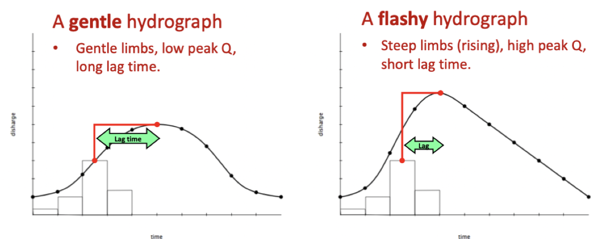
flood hydrographs terms
Peak rainfall= time of the highest rainfall level
Peak discharge= time of the highest river discharge
Lag time= difference in time between the peak rainfall and peak discharge
Rising limb= increase in river discharge
Falling limb= fall in river discharge
Peak discharge= time of the highest river discharge
Lag time= difference in time between the peak rainfall and peak discharge
Rising limb= increase in river discharge
Falling limb= fall in river discharge
33
New cards
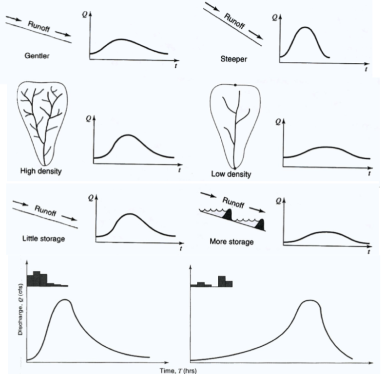
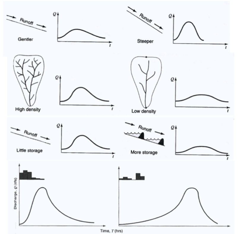
factors that affect the shape of the hydrograph
Watershed hillslope gradient: steeper generally gets water to the river faster
Drainage density: how many streams flow into a river at a certain point
Surface storage e.g. dams, lakes, reservoirs, flatten the hydrograph
Temporal and spatial distribution of rain fall, where it falls in the catchment
weather, climate,
Drainage density: how many streams flow into a river at a certain point
Surface storage e.g. dams, lakes, reservoirs, flatten the hydrograph
Temporal and spatial distribution of rain fall, where it falls in the catchment
weather, climate,
34
New cards
gentle and flashy hydrograph
Flashy: river discharge increases rapidly over a short period of time
Rainwater reaches river quickly- high tendency to flood
Occur in urban areas, rivers with low rock/catchment permeability and on steep catchments, small basin
* Water cant go through the concrete and asphalt (less infiltration) running off the surface quickly,(infiltration excess runoff),Lack
of vegetation
Gentle: Gentle limbs, low peak discharge and a long lag time, areas with low relief and permeable soils, where water infiltration and runoff occur at a slower rate.
35
New cards
airflow over foredunes
Wind accelerates up the hill, the flow will accelerate when it has been compressed
Blow outs expand because the wind funneled through the blowout maintaining a vegetation free zone
Due to compression there is a higher wind speed near the top, create conditions for sand to get blown out
which maximises erosion
Blow outs expand because the wind funneled through the blowout maintaining a vegetation free zone
Due to compression there is a higher wind speed near the top, create conditions for sand to get blown out
which maximises erosion
36
New cards
Threshold velocity wont get the particle to move
* Based on a single grain on a flat surface and is perfectly spherical
* The sand grain on the beach sits inside of the other sand grains, only part of the grain is exposed ( part of grain is always hidden)
* Need an excess of the threshold velocity for it to move
37
New cards
vegetation is crucial for
dune stability
38
New cards
Starting conditions for sand dunes
* Either a river or coast (no vegetation, delivery of sand)
* Location with a coastline that’s prograding, gets lots of separated beach ridges, wet sand won’t move as it’s held in position due to cohesion- From material blown onto the beach
\
If you hold the beach in position for a long time, dune builds up
Beach eroding- scarps form
39
New cards
blowout shapes
Dune edge breaches wash out during storm or high tide- Don’t create dunes inland
Airflow funnels into a gap and the dune extends- Propels sand inland
Airflow funnels into a gap and the dune extends- Propels sand inland
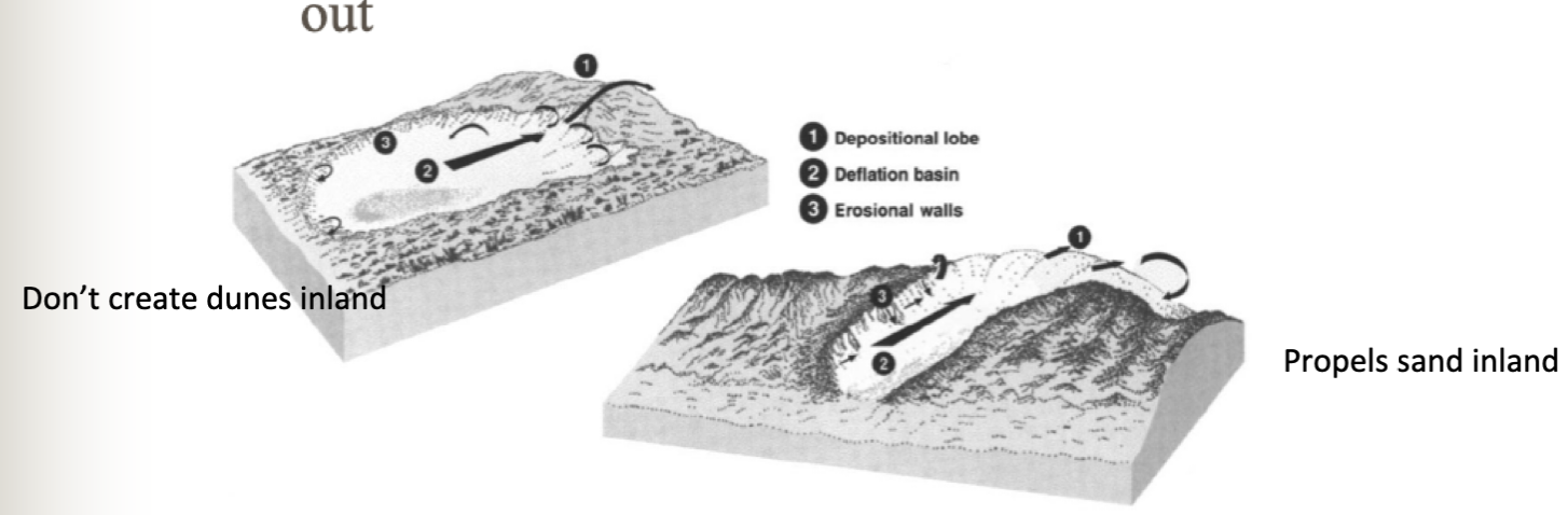
40
New cards
dunes and wind
Dunes align along the net vector direction of the wind flow
Only the stronger winds will move a lot more sediment
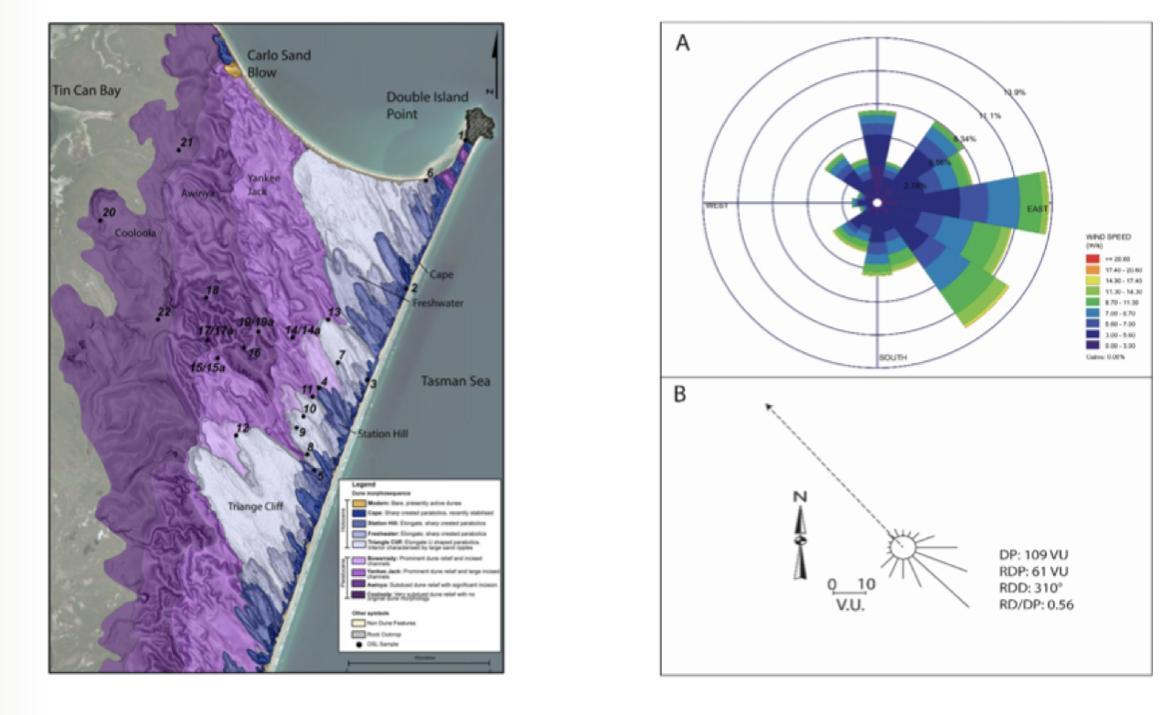
A=Shows direction wind is coming from, Direction of wind towards to NW
B=Wind drift potential, A lot of sand will go to the NW
Storm hits the coast with a given amount of energy, no dunes, and then the energy goes to roads and buildings. The sand acts as a buffer
Only the stronger winds will move a lot more sediment
A=Shows direction wind is coming from, Direction of wind towards to NW
B=Wind drift potential, A lot of sand will go to the NW
Storm hits the coast with a given amount of energy, no dunes, and then the energy goes to roads and buildings. The sand acts as a buffer
41
New cards
sub-areial dunes depend on
depends on whether there is sand available to move or not
vegetation cover
Can the wind directly access the sand
vegetation cover
Can the wind directly access the sand
42
New cards
linear dunes
Dunes of sand starvation
* Not much sand in the landscape
* Wind organises the sand in linear ridges
* Wind circulations between edges= any sand that ends on flat areas between gets blown back onto the ridges
Fixed in position, Bimodal winds
Little vegetation- cant stop formation of dunes
* Have more vegetation than surrounding country, but the wind can still get to the sand
deserts
\
43
New cards
Why do linear dunes elongate but don’t change position
Linear dunes are often asymmetric due to the differences in the strength of the 2 wind fields’
wind direction from S in winter and NW in summer= get a net vector of direction. Dominant wind from, more of a push from the NW side,
Inside the dune, the zone on top that’s active, crest will lean in the direction of the net wind and will move seasonally.
Trace linear dune back to the source
Temp rivers, get flushes of sediment, from the edges of the rivers, the dunes are developed
44
New cards
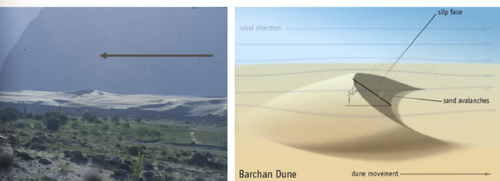
parabolic dunes
can see Blow outs, generate new bog parabolic dunes, Some at the coastline but are v small
Unlimited sand available, hard for wind to get the sand, as there is forest cover
Depends on an erosional gap of blow out which the wind can exploit
Erosional gap in the middle of the dune, and the middle of the dune has winds which pushes through and leaves a trail, one side larger than the other (aligned with the wind)
45
New cards
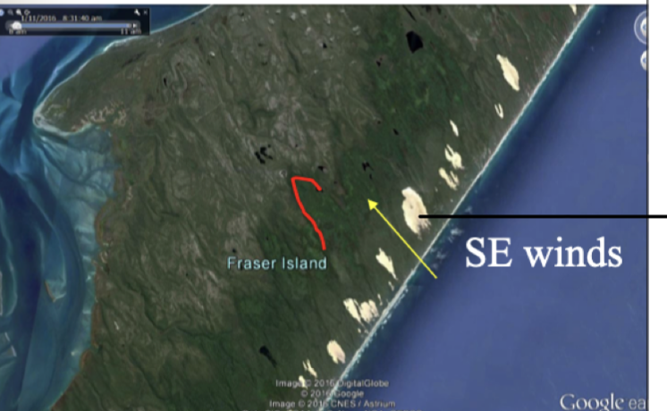
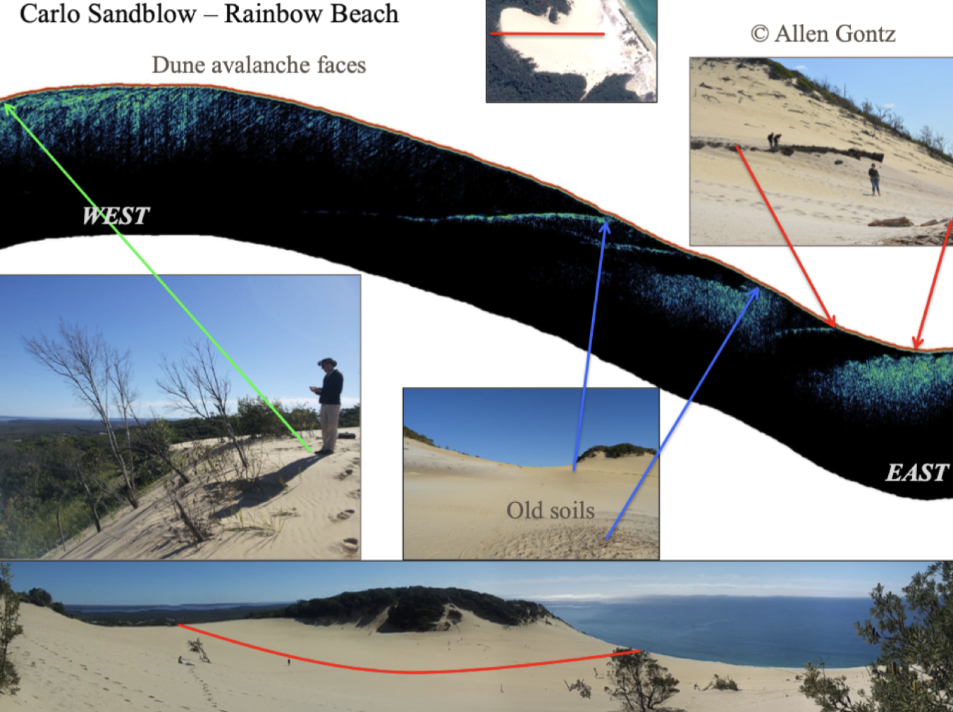
carlo sandblow- rainbow beach
W- see diagonal lines, wind catches sand near the coast, pushes the sand through, and the diagonal lines show the migration of the dune through the countryside
E- Harder, material, development of soil, exposed to light and heat, bakes into a chemical rock
Current blowout is eroding through fast dues
Heavily vegetated landscape, buries trees as it goes across
46
New cards
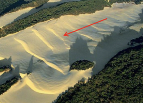
transverse dunes
Inside of a parabolic blowout
4 blow outs that have been migrated and have joined, have no choice but to migrate through the dense forest
Supply limitation= duenes aligned down the wind
Lots of supply, dunes turn around, so once in an open area they are at right angles to the direction of the wind
Each sand wave is a transfer dune
47
New cards
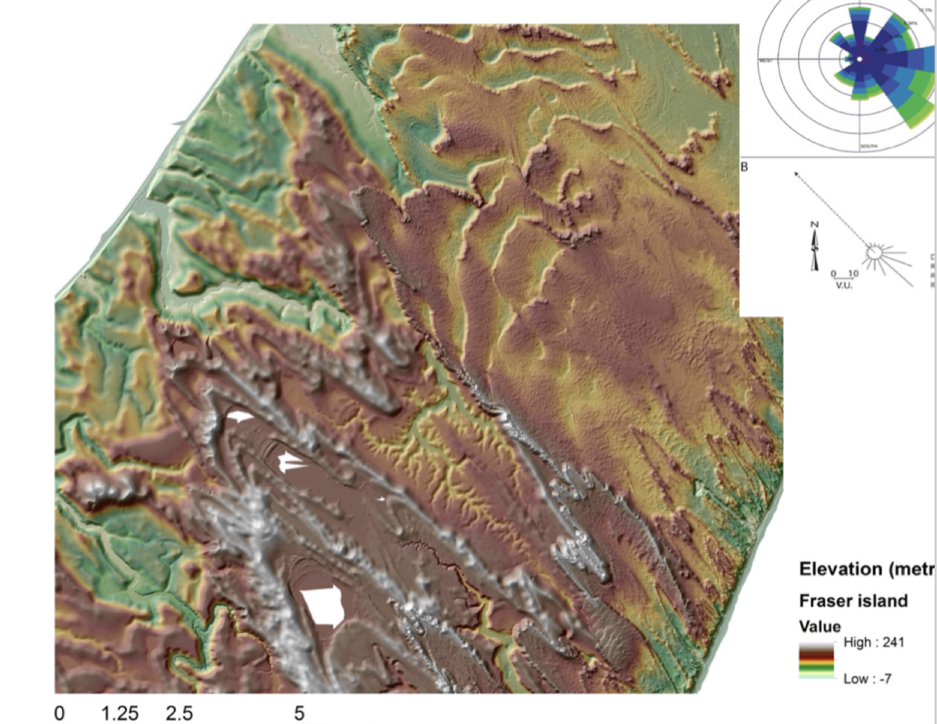
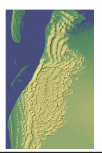
analysis of this picture
transverse: Sharp ridge going across= parabolic migrated off this coast and it migrated across the whole island, blow outs migrate rapidly inland
NW: Remnants of dunes, time series, dunes at modern beach= recent, dunes near 6000yrs old, parabolic= 180,000yrs, Green= 350,000 yrs- 1000000
front middle: White= parabolic- hook shapes on the end of them, migrating through a forested area
Older= less formed, angle of repose= highest angle at which the material will support itselfs,
Dune at 10 deg the sand wont migrate
Steeped up the angle of repose
48
New cards
coastal dunes in France
No strongly developed parabolic form
Area covered in forest
Wind will "freeze" in place
Each line represents a coastal potion that has been filled up with sand and then abandoned and move on
Coast- long term house will be safe as the sand is moving into the sea
Area covered in forest
Wind will "freeze" in place
Each line represents a coastal potion that has been filled up with sand and then abandoned and move on
Coast- long term house will be safe as the sand is moving into the sea
49
New cards
not all dunes point in the same way
Form with a nose into the wind, and the trail being down wind of what the wind direction is
50
New cards
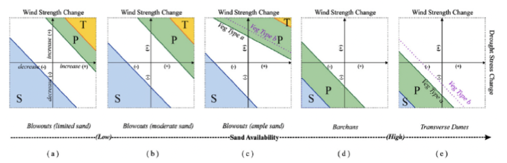
model of dune change
Dunes forming parabolic, get position where they join together, will get an area where you will get transverse dunes
Increase in sand availability through increasing wind strength or drought stress ( decrease vege)
White= no change, but ready to go if a disruption
Reduce wind speeds or allow vegetation to form, transition from transverse to parabolic
Increase in sand availability through increasing wind strength or drought stress ( decrease vege)
White= no change, but ready to go if a disruption
Reduce wind speeds or allow vegetation to form, transition from transverse to parabolic
51
New cards
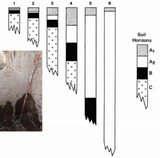
podsol development
Soils developed on dunes is dominated by podzolization, soil increases in thickness with age
Initially become more nutrient-rich
But as soils continue to deepen, nutrient status declines
Layer on top= of organic litter, producing acids that wash into the sand
End up with pure white sand,
Can be bright orange yellow soils
52
New cards
erosion of dunes
Go from youth to old age
Then something comes and lifts it up again and the cycle restarts
Then something comes and lifts it up again and the cycle restarts
53
New cards
non-tectonic settings dunes
Away from nz
Gradual landscape lowering
Soil diffusivity = weathering process going on in top soil and have a zone before underlying rock where you have broken up rock and soil,.
Loose material at top of hill, will go down by soil diffusion processes
Steeper slope faster the diffusion down the slope
54
New cards
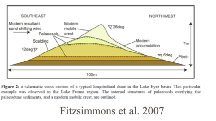
once dunes are emplaced, how do they evolve?
There are records of what the dunes look like at different time periods
Typical shape of dunes: Convex then concave with flat in the middle
Gradually reduce convexity of one end of slop and concavity over time
Through time curvature evens out
Curvature can help work out the age
* Younger= steep dunes with high curvature, have small scale landslides occurring, Fire will disrupt the slope and sediment slips down the slope
* Older= gentle and lower curvature
Pretty good match for 1st 3 major peaks with changing sea levels
Disruption at the beach when dunes forming, dunes at the back at the beach more inclined to be over run by storm events, moving them
55
New cards
what records can we obtain from dunes?
fire records
There was one big fire that burnt half the island and caused lots of damage
2 phases
* layers of charcoal
* Layer above it with continuous charcoal
Can measure individual fires going through
* material becomes buried in Lakes and ponds
* Use buried dune records to reconstruct fires
There was one big fire that burnt half the island and caused lots of damage
2 phases
* layers of charcoal
* Layer above it with continuous charcoal
Can measure individual fires going through
* material becomes buried in Lakes and ponds
* Use buried dune records to reconstruct fires
56
New cards
what forces act on a grain of sand
impelling force: Power relationship, ability to move sand grains increases exponentially as the wind speed increases
resisting stress: Much easier for things to move in water, as it is denser as has more mass, and more force
also shear and resisting stress
resisting stress: Much easier for things to move in water, as it is denser as has more mass, and more force
also shear and resisting stress
57
New cards
entrance processes of IOCES
Intermittently open/closed estuaries
Periodically close by the formation of a berm/bar across the mouth
Influenced by rivers and tides but mostly wave dominated
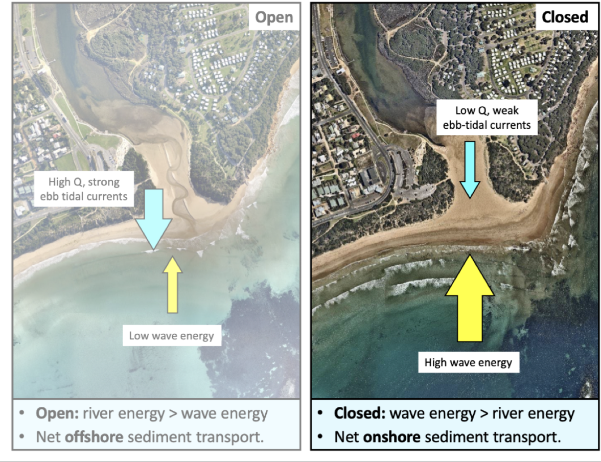
Competing energies (Onshore sand transport by waves vs ebb tidal currents (outgoing tide and river flow)
* Open: high river discharge and strong ebb tidal currents
Low wave energy which causes net offshore sediment transport
* Closed: low river discharge, weak ebb tidal currents
High wave energy which causes net onshore sediment transport
\
Periodically close by the formation of a berm/bar across the mouth
Influenced by rivers and tides but mostly wave dominated
Competing energies (Onshore sand transport by waves vs ebb tidal currents (outgoing tide and river flow)
* Open: high river discharge and strong ebb tidal currents
Low wave energy which causes net offshore sediment transport
* Closed: low river discharge, weak ebb tidal currents
High wave energy which causes net onshore sediment transport
\
58
New cards
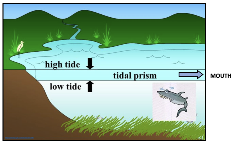
entrance processes of IOCES: tidal and ebb tidal prism
Tidal prism= the volume of water exchanged over a tidal cycle
Ebb-tidal prism= tidal prism and outgoing river flow
Ebb-tidal prism= tidal prism and outgoing river flow
59
New cards
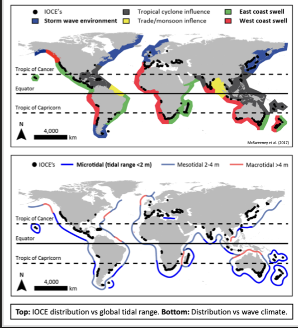
global distribution of IOCES
More common in micro-tidal estuaries
Need
Relatively consistent high-wave energy
* Berm building
* Swell-dominated coasts with bigger waves
Small tidal range
* Weak tidal currents at the entrance (allows sand to stabilize the mouth)
* Micro and meso coasts with a tidal range from 0.5 to 2.5m
* variability seasonally and interannually, sometime it will be low river flow, easier for waves to win, high rainfall all the time= hard for waves to bring sand onshore
* Rivers with low mean annual and specific discharge
* Smaller rivers and catchments
* Common on rivers with variable flow regimes
60
New cards
NZ distribution of IOCES
East coast of the South Island and Northland
why?
* Variable, mostly dry compared to W
* Low flow rivers and seasonal
* High ocean waves, small tidal range, rivers that have seasonally low flow
61
New cards
opening processes of IOCES Catchment
Periods of high rainfall and river flow
Raise the water level of the lagoon and sits inline with the sand berm and spills over top, thin flow and gradually widens the channel
elevation difference between them causes a channel to be mad
\
Raise the water level of the lagoon and sits inline with the sand berm and spills over top, thin flow and gradually widens the channel
elevation difference between them causes a channel to be mad
\
62
New cards
opening processes of IOCES marine
overtopping and seepage
* Big strong waves that spill water into the lagoon, add a little bit of water for the lagoon to go over the threshold
* Berm saturated already, sapping/seepage; big indents, water takes sediment with it
* if it keeps happening, causes cracks and induces mechanical failure of the berm
* Big strong waves that spill water into the lagoon, add a little bit of water for the lagoon to go over the threshold
* Berm saturated already, sapping/seepage; big indents, water takes sediment with it
* if it keeps happening, causes cracks and induces mechanical failure of the berm
63
New cards
opening processes of IOCES mechanical (artificial)
* people open it before the natural threshold is reached
* Dig a channel from the edge of the lagoon out to sea
* Improves water quality stuff like algal blooms, and bad temp, goes out to sea, and leaves good stuff behind
* Fish passage: Salmon and eels that need to get out to migrate - cultural significance as mahinga kai species
* Flood mitigation: Water went into the lagoon and raised the level enough for it to open.
* Affects floodplains and agriculture, people and recreational sites, Getting rid of flooding, stranded communities
\
64
New cards
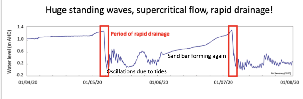
standing wave sin IOCES
Standing waves working, forms under supercritical flow, water moving fast and is turbulent
Getting rid of flooding
Ecological risks associated
Bumps in water surface, antidunes that migrate upstream and then collapse
Getting rid of flooding
Ecological risks associated
Bumps in water surface, antidunes that migrate upstream and then collapse
65
New cards
Geomorphic change
* Slow to kick off, Subcritical flow, slowly starting to increase in velocity, Mouth not being super high
* Supercritical flow, expanding quickly, deeper and winder and increase in velocity increase in discharge
* Water level decreases, while discharge and channel width increase further
not all follow this pattern
Measure near continuous geomorphic change at the estuary mouth and linking it to change in basin water level
66
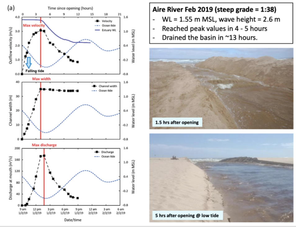
New cards
opening up ICOES on a steep grade
Grade= energy gradient between estuary and the sea
Opened with steep grade so have big elevation between estuary and the tide but not much distance for that to travel across
Go through sequence of change quickly = Reach peak within a few hrs
Opening- velocity reaches it peak (within a few hrs) then tapers off quickly
Same with channel width
Hydrograph discharge= sharp
Opened on a falling tide, grade was getting steeper
67
New cards
opening up ICOES on a lower grade
Lower grade, when opened took a long time to really kick off and reach its peak velocity, width, discharge
Opened on a rising tide, the grade wasn’t getting steeper, was getting more gentle
Opened on a rising tide, the grade wasn’t getting steeper, was getting more gentle
68
New cards
when can artificial openings fail
Big waves that bring sediment onshore to infill the channel- stormy seas
Insufficient energy to maintain offshore transport to push sand offshore, waves can deposit sand and shit the channel
Combination of above
120m long channel, grade is low, didn’t have the potential energy to move sand off shore at the mouth
Insufficient energy to maintain offshore transport to push sand offshore, waves can deposit sand and shit the channel
Combination of above
120m long channel, grade is low, didn’t have the potential energy to move sand off shore at the mouth
69
New cards
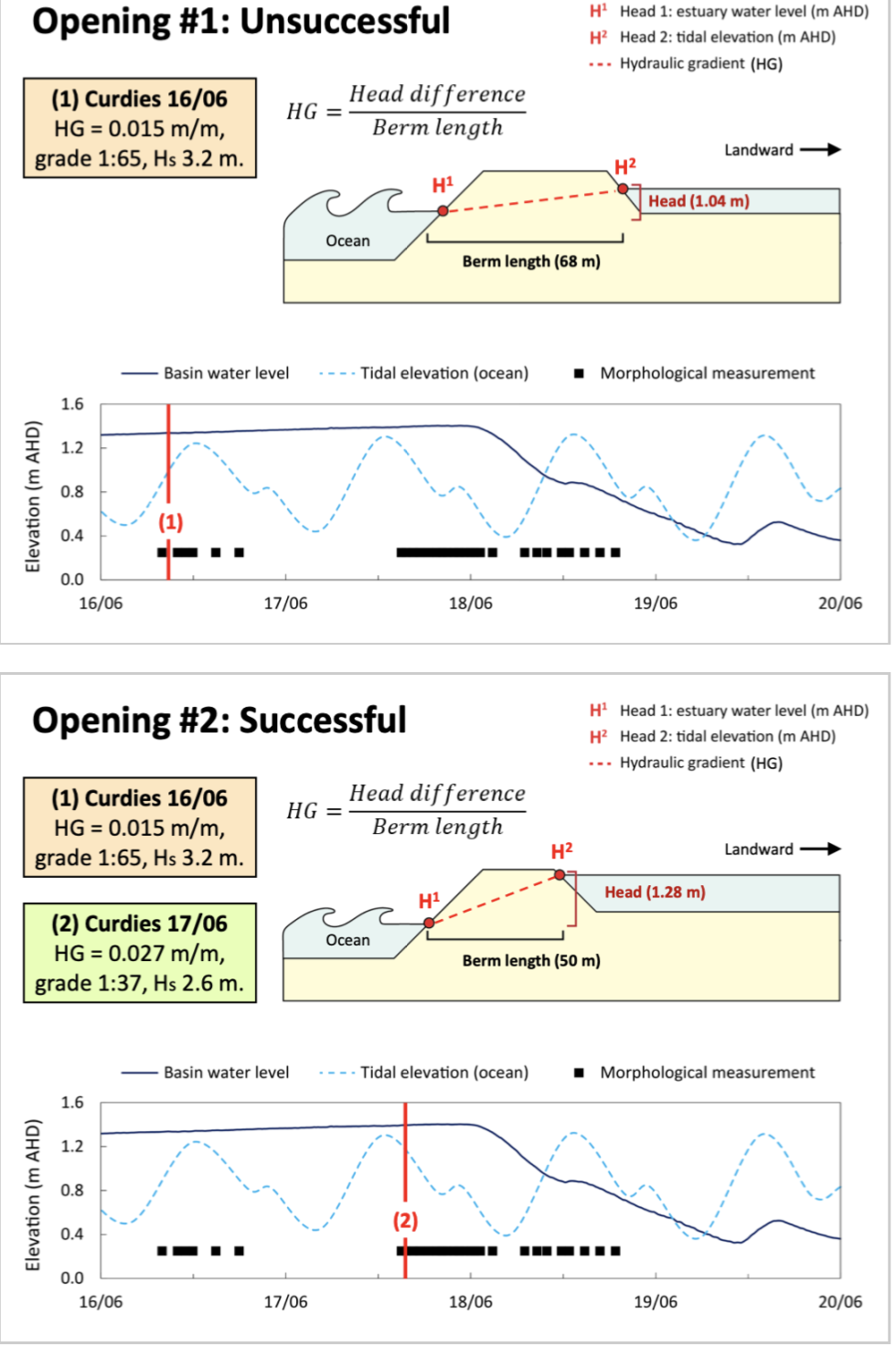
how to predict wether an artificial opening will fail or succeed
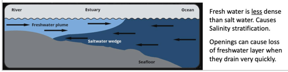
Grade steeper than 1:60 ratio is needed for a successful opening and waves lower than 4.3m to avoid infilling from ocean
Low grade, high waves and on a tide that was rising so decreasing the head, so it closed off
Within grade threshold, steeper, low waves and did it at a falling tide= successful
Low grade, high waves and on a tide that was rising so decreasing the head, so it closed off
Within grade threshold, steeper, low waves and did it at a falling tide= successful
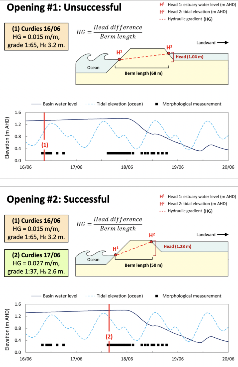
70
New cards
ecological implications of opening IOCES
Open at really steep grades and track through drainage sequence quickly = bad for lagoon
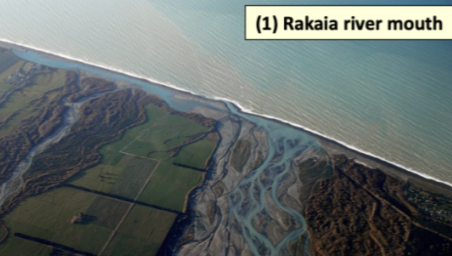
Stratification: Freshwater sits on top of normal water, all deoxygenated water can result in fish kills.
Need to take note of water quality in lagoon, low dissolved oxygen not a good idea to open, see the oxygen rich layer drain off and what's left behind will suffocate the fish
71
New cards
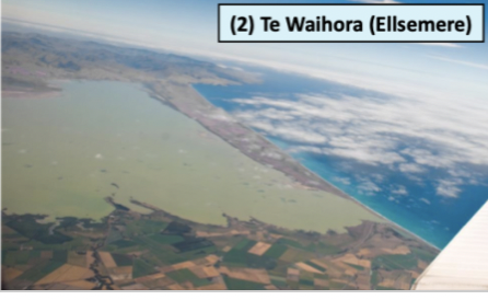
**Hapua**
braided river mouth lagoons
Form on mixed sand and gravel beaches
Shore parallel barriers built by longshore drift
Build by sediments being pushed by the currents of the river
Don’t have a lot of tidal influence, due to mouth being offset, doesn’t allow for tides to come in and change the water levels
Wave dominated estuaries
Form on mixed sand and gravel beaches
Shore parallel barriers built by longshore drift
Build by sediments being pushed by the currents of the river
Don’t have a lot of tidal influence, due to mouth being offset, doesn’t allow for tides to come in and change the water levels
Wave dominated estuaries
72
New cards
**Waituna**
freshwater coastal lagoon, which is large and lake-like
Form on mixed sand and gravel beaches
Shore parallel barriers built by longshore drift
Wave dominated estuaries
Smaller rivers that flow into them, tend to have lower flows, closed for long periods of time
Water and stuff that comes in sits for a long time before it goes out to sea
Form on mixed sand and gravel beaches
Shore parallel barriers built by longshore drift
Wave dominated estuaries
Smaller rivers that flow into them, tend to have lower flows, closed for long periods of time
Water and stuff that comes in sits for a long time before it goes out to sea
73
New cards
Hapua and Waituna in NZ
Lots of the East coast of S Island, some on W too
Lots of mixed sand and gravel beaches
High energy coastlines
Natural river flow regimes, severely altered by high levels of water extractions (Variable river flow, push through the barrier)
Small tidal range
There isn’t many hapua in the North Island as they don’t have many braided rivers and super steep mountains
74
New cards
what shapes Hapua and Waituna morphology
**Tectonics and sediment**: Southern Alps that provide coarse material that is brought down from the mountains by alluvial fans and braided rivers and break it down
**Coastal processes:** southerly waves generate a northward longshore drift current which builds shore parallel barriers of coarse sediment
Under a lot of pressure due to irrigation processes, water abstraction, catchment land use change
**Coastal processes:** southerly waves generate a northward longshore drift current which builds shore parallel barriers of coarse sediment
Under a lot of pressure due to irrigation processes, water abstraction, catchment land use change
75
New cards
significance of Hapua and Waituna
Important habitats for native flora and fauna, mahinga kai and taonga species e.g. cockles, flax and eels
Fisheries= recreational
Culturally important
* Source of mana
* End of hapua are indicators of catchment ecosystem health and the state of the mauri of the river
* Carefully managed by tangata whenua for generations
Fisheries= recreational
Culturally important
* Source of mana
* End of hapua are indicators of catchment ecosystem health and the state of the mauri of the river
* Carefully managed by tangata whenua for generations
76
New cards
hapua materials
Mix of coarse sand and pebbles
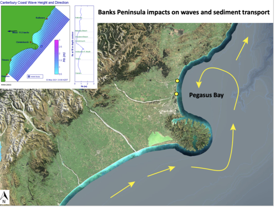
* Exceptions= Ashley and Waimalariri river as they enter the coast on sandy beaches, due to reduced wave energy from the shelter from banks peninsula
\
waves hit the banks of the peninsula and then will lose a lot of energy so pegasus bay will receive the material
Exist on coasts that are chronically eroding, the rivers feeding into the hapua have high sediment loads so can eventually close
77
New cards
why are Hapua are eroding even though there is high sediment supply?
Sediment is making it to the coast but then its being moved further on and not making it back
Need coarser material, to build up the barrier, silts and fine muds are wont build up
People are extracting gravel from the floodplains
water limits being ignored
Need coarser material, to build up the barrier, silts and fine muds are wont build up
People are extracting gravel from the floodplains
water limits being ignored
78
New cards
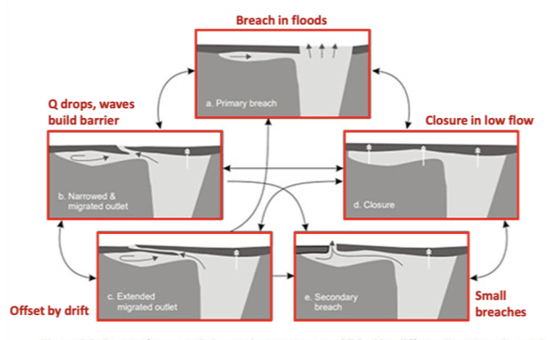
opening and closure of hapua
Wave vs fluvial processes
Close during low flow as the energy from the waves are "winning" until flow picks up and net energy dominates over waves= open mouth
Then when flood occurs the barrier is breaches by a main channel
Undergo a cycle of infill and erosion related to floods
When closed the water can seep through the barrier as there is coarse sediment
79
New cards
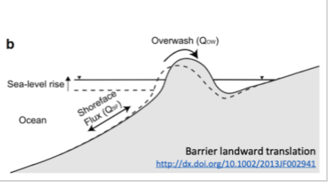
wave overwash hapua
Big waves go overtop the barrier and push into the lagoon
Can get movement of materials into the lagoon
Can cause barrier to roll backwards into lagoon, reduces its size
Reduces buffer space between houses
Can narrow the lagoon and move sediment into the lagoon
occurs during storms
High tide, big flood flow in river, water cant push out mouth, so holds back water and will flood towns, Erosion of back-cliffs
80
New cards
opening and closing in Waituna
Most are closed and may need to be opened artificially
Closures last typically months-years (longer than hapua)
Closures last typically months-years (longer than hapua)
81
New cards
Lake Ellesmere
Culturally significant to Ngai Tahu, ecological significance= aquatic wetland ecosystems
Suffered environmental degradation
Fed mostly by ground water with many springs in the catchment, there has been a decrease in groundwater levels
Due to an increase in people taking water out for drinking or agriculture
Suffered environmental degradation
Fed mostly by ground water with many springs in the catchment, there has been a decrease in groundwater levels
Due to an increase in people taking water out for drinking or agriculture
82
New cards
formation of lake ellesmere
With rising sea levels, spit began to form and was fed material moved alongshore from Rakaia
Spit closed off the Ellesmere embayment, which creates an enclosed freshwater lake
A permanent channel was established, and estuarine conditions were re-established
Lake started to close via the spit (longshore drift) as wasn’t getting the flow from the river
Water quality issues to long residence times
Hypertrophic and super saturated with P and N due to long residence times, trapping and storing nutrients
83
New cards
management issues with lake ellesmere
Co-governance to restore the lake
Replanting of riparian margins
Establishment of macrophyte beds
Ecan and Ngai Tahu work together to make sure it is the right conditions to artificially open the estuary e.g. timing it with fish making sure it is the right conditions
84
New cards
Te Wairewa
Te Wairewa is important to the Maori tribes and they use the lake to catch and harvest eels
As barrier is pushing out makes it harder for building channels to catch them and for the eels to compete their migration
are a mahinga kai species
85
New cards
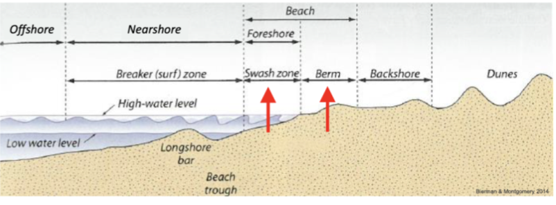
beach profile, types of shores
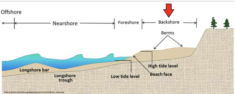
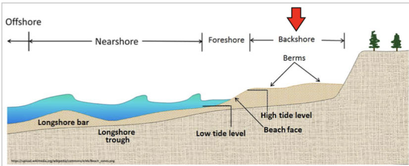
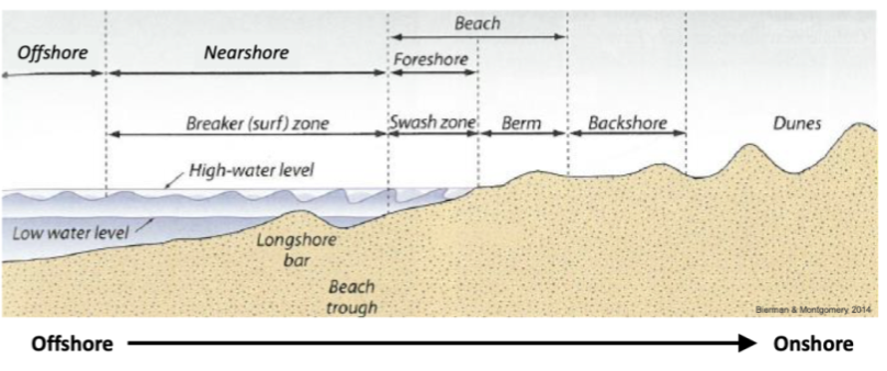
Backshore
* Dry under normal conditions, storms= wet
* Above high tide limit
* Beach and berms
Foreshore
* Intertidal zone
* Low tide= dry and exposed
* Top of the berm to water line
Nearshore
* Underwater, shallow water processes
* Swash zone to deep water
* Wave breaking
86
New cards
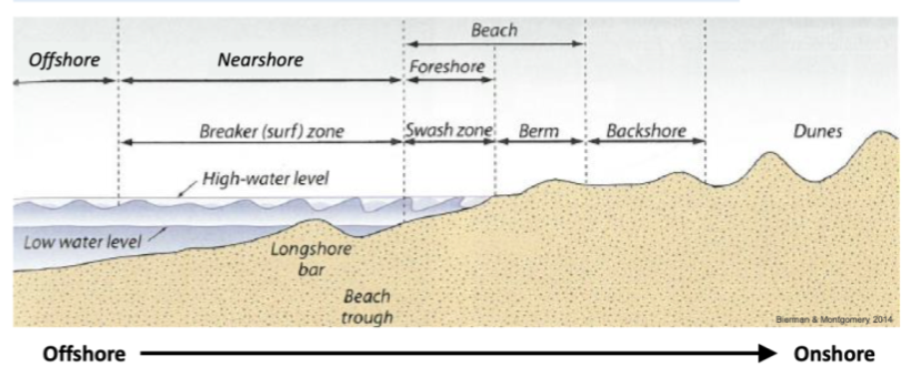
diagram to draw beach profile
87
New cards
beach profile energy gradient across active profile
Offshore
Deep water waves (lower energy, not interacting with the sea floor, fine grains
Breaking waves, higher energy, Waves are starting to break and release their energy, stir and move sediment on sea floor, coarse grains
Onshore
Aeolian processes, lower energy, Wind processes but don’t have as much energy as a wave, finer sediment
88
New cards
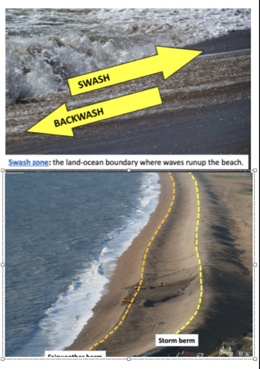
swash zone and berm
swash= onshore flow, Waves have broken, smaller. Pushing sand grains up with it
Backwash= offshore flow
berm= Flat area, limit of where waves are rushing up and down the beach face, form due to the deposition of material by waves
\
Backwash= offshore flow
berm= Flat area, limit of where waves are rushing up and down the beach face, form due to the deposition of material by waves
\
89
New cards
berm= storm and fair weather conditons
fair weather= waves push more sediment onshore than they erode as backwash (low waves flat beach)
Storm berm= More powerful waves, which erode more sediment offshore, backwash stronger than swash, Narrow beach and offshore bar storage
fair weather return: Low waves and then the bar moves back onto beach
Storm berm= More powerful waves, which erode more sediment offshore, backwash stronger than swash, Narrow beach and offshore bar storage
fair weather return: Low waves and then the bar moves back onto beach
90
New cards
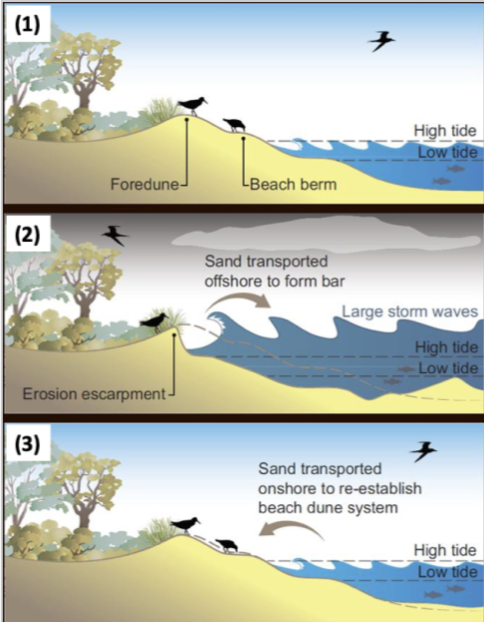
seasonal changes in beach profile
Summer: low wave height, sediment moves onshore, beach is wide and flat
Winter: higher waves, sediment moves off shore, beach is narrow and steep
Winter: higher waves, sediment moves off shore, beach is narrow and steep
91
New cards
how do beach profiles form?
\
\
1. Tidal Influence: Tides, which are caused by the gravitational pull of the moon and the sun, influence beach profiles by causing the rise and fall of sea levels. The cyclic tidal movements can result in the deposition or erosion of sediment, affecting the shape and elevation of the beach.
2. Wind and Currents: Wind and ocean currents also play a role in shaping beach profiles. Strong winds can create waves and generate currents that transport sediment along the shoreline. These processes contribute to the formation of different beach features, including dunes, spits, and cusps.
3. Geological Factors: The underlying geology of a coastal area can influence the formation of beach profiles. The composition and structure of coastal sediments, such as sand, gravel, or rock, can impact the beach's slope, texture, and overall shape. Geological processes like erosion and weathering also affect beach profile development.
4. Human Interventions: Human activities, such as coastal engineering and beach nourishment projects, can alter natural beach profiles. The construction of seawalls, groynes, or breakwaters can modify wave patterns and sediment transport, resulting in changes to beach morphology.
92
New cards
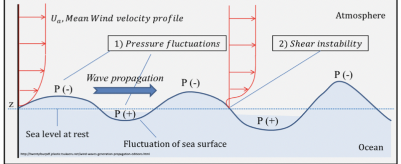
wave generation in the ocean
* Generated by vertical displacement of water (Blowing on surface on sea which creates a bulge of water that travels across).
* Winds acting on the ocean surface
* Extreme (sudden) events e.g. tsunami
* Ultra low-frequency processes e.g. tides (Crest in the wave doesn’t pass very often)
93
New cards
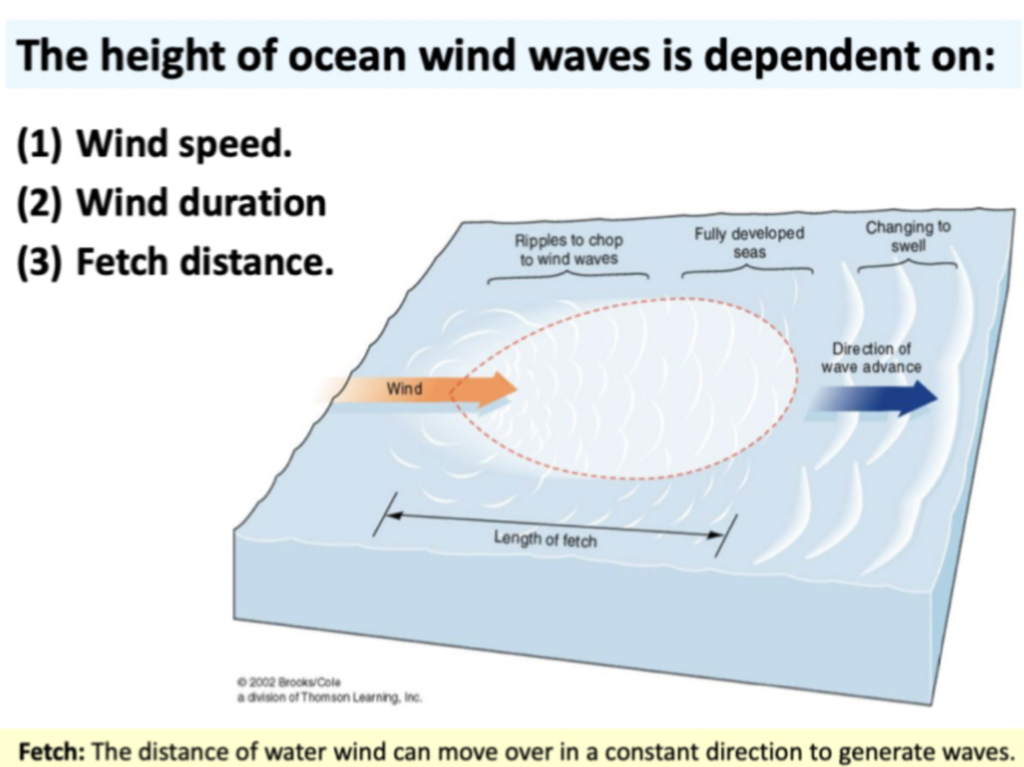
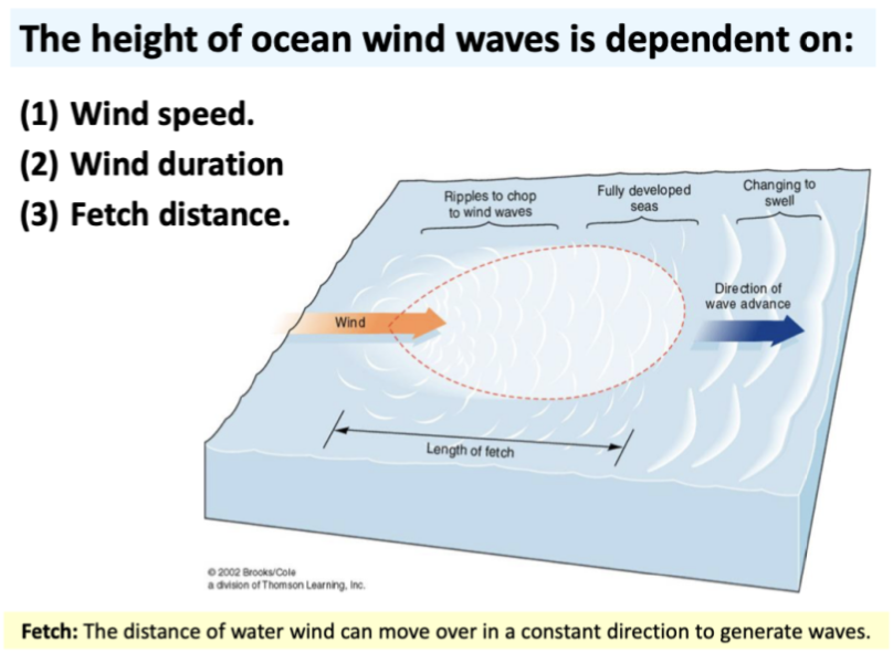
The height of ocean wind waves is dependent on
* Windspeed; Higher waves as more energy transferred to sea surface
* Wind duration; More energy being transferred over a longer period of time
* Fetch distance Distance of water of the ocean where the wind is blowing in a common direction
94
New cards
wave process source to shore
Waves organise themsleves by period and travel in groups called swells
\-Energy from wind being transferred to the waves
\-Waves travel in a similar direction and propagate, waves that travel the same speeds will travel together
\-Interact with bottom of ocean form, release energy
95
New cards
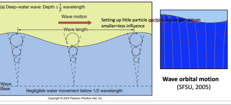
wave motion
Water particles undergo circular orbital motion when waves pass
Occurs in the direction of the passing wave, due to friction
Orbital diameter decreases with depth
deep
* no interaction with bottom, no motion at wave base
Intermediate
* Drag on the bottom of the sea floor, Bottom orbit slowing down top moves faster
Shallow
* Orbits are starting to drag at the bottom, top goes faster than the bit underneath the wave will break
96
New cards
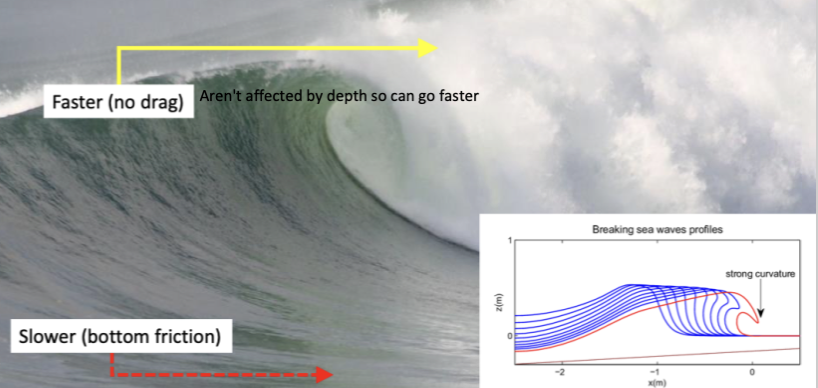
wave shoaling
waves feel the ground and interact with sea floor
Waves moving from deep to shallower where they interact with seabed
\
Waves become higher and steeper as the orbits interact with the bottom, due to the friction of the interaction the sea celerity decreases, the height increases due to friction
Steepness of wave increases which causes it to break
Waves moving from deep to shallower where they interact with seabed
\
Waves become higher and steeper as the orbits interact with the bottom, due to the friction of the interaction the sea celerity decreases, the height increases due to friction
Steepness of wave increases which causes it to break
97
New cards
waves and beach profiles
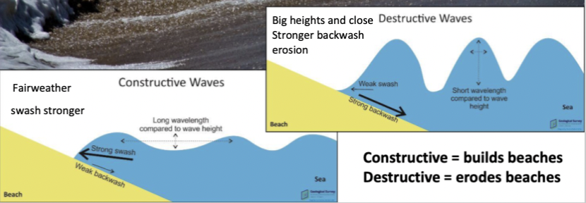
Constructive waves build beaches = Fairweather and swash stronger, more sediment entering the beach
Destructive waves erode beaches= Big heights and close together, more frequent energy, Stronger backwash= erosion
The intensity and direction of wave action contribute to the formation of different beach profiles.
Destructive waves erode beaches= Big heights and close together, more frequent energy, Stronger backwash= erosion
The intensity and direction of wave action contribute to the formation of different beach profiles.
98
New cards
beach profile and Sea level rise
* Tides act as a base level for waves, an increase in base level= waves reaches further inland
* Higher tides can increase the inland extent of coastal inundation and erosion
* SLR will amplify the effects of storms and big tides
Sea level come up, beaches want to maintain eq profile, sea level comes up, keep the same form but just roll upwards in sand dunes
Rising sea levels can submerge and erode beaches
99
New cards
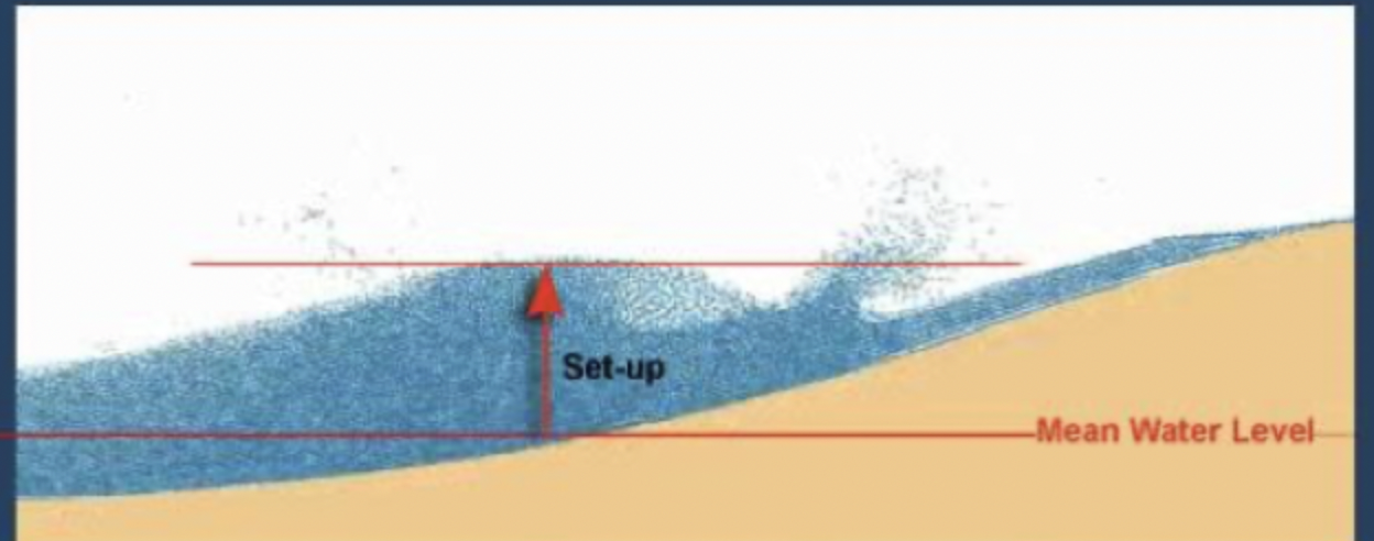
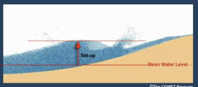
wave set up and set down
Set up: waves breaking along the shoreline and stack up ontop of each other, piles along shoreline
Set down, Undertow from setup that flows seaward beneath incoming waves
Set down, Undertow from setup that flows seaward beneath incoming waves
100
New cards
Rips
Strong offshore currents caused by 3d seaward return, high set up to low, concentrated in narrow zones of the beach