ATOC10001
0.0(0)
Card Sorting
1/221
Earn XP
Description and Tags
Last updated 10:25 AM on 11/13/22
Name | Mastery | Learn | Test | Matching | Spaced | Call with Kai |
|---|
No analytics yet
Send a link to your students to track their progress
222 Terms
1
New cards
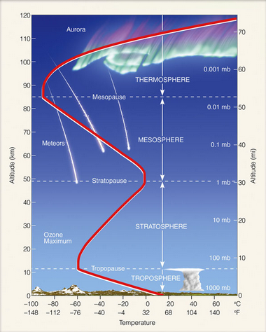
The atmosphere
- relatively thin barrier that separates us on the Earth's surface from outer space
- Troposphere, Stratosphere, Mesosphere, Termosphere
- Troposphere, Stratosphere, Mesosphere, Termosphere
2
New cards
Ionosphere
the lower part of the thermosphere, where electrically charged particles called ions are found
- encompasses parts of the thermosphere and mesosphere
- atoms are stripped of their electrons
- consequence of absorption of energy due to cosmic rays and solar winds = aurora borealis/ australis
- encompasses parts of the thermosphere and mesosphere
- atoms are stripped of their electrons
- consequence of absorption of energy due to cosmic rays and solar winds = aurora borealis/ australis
3
New cards
homosphere
heterosphere
heterosphere
- Homo: gases are will mixed due to turbulence in the atmosphere
- Hetero: gases are quite different
- Hetero: gases are quite different
4
New cards
Diagram of atmosphere
- Homosphere located from Stratosphere down
- Hetero and Iono located Stratosphere and above
- Hetero and Iono located Stratosphere and above
5
New cards
Pressure equation
P=dRT; R= 287J/kg/K
6
New cards
Troposphere
- Layer where most action occurs
- 80% of mass of the atmosphere and almost all water vapour is in this layer
- 80% of mass of the atmosphere and almost all water vapour is in this layer
7
New cards
tropopause
The boundary between the troposphere and the stratosphere.
- higher in equatorial regions and lower at the poles, due to convection and surface heating in the tropics making the layer where there is air turning thicker
- higher in equatorial regions and lower at the poles, due to convection and surface heating in the tropics making the layer where there is air turning thicker
8
New cards
Temperature and height
Generally, decreases with height but very near the surface this isn't always the case; often due to overnight surface cooling
9
New cards
Inversion
Increase in temperature with height
10
New cards
Stratosphere
- Stable
- 20% of atmosphere's mass
- Much drier than troposphere but some water vapour
- As temp rises with height this layer is very stable; relatively little vertical motion
Temp increase with height is due to ozone absorbing shortwave solar radiation
- 20% of atmosphere's mass
- Much drier than troposphere but some water vapour
- As temp rises with height this layer is very stable; relatively little vertical motion
Temp increase with height is due to ozone absorbing shortwave solar radiation
11
New cards
Temp increasing with height
- due to ozone at higher levels in the stratosphere absorbs radiation before it can reach lower stratosphere
- deep convection can spill over into the stratosphere transferring water vapour from troposphere
- moisture from clouds spilling up into the stratosphere; tropical regions
convection passes through tropopause
- deep convection can spill over into the stratosphere transferring water vapour from troposphere
- moisture from clouds spilling up into the stratosphere; tropical regions
convection passes through tropopause
12
New cards
Mesophere
- Where meteors burn up
- much lower ozone concentrations in this layer compared to stratosphere, means that temperature decreases with height again
- much lower ozone concentrations in this layer compared to stratosphere, means that temperature decreases with height again
13
New cards
Thermosphere
- Ionisation because electrons are excited by solar radiation and there is a greater absorption at higher level; Aurora
- fewer particles
- above 100km no effective mixing
- fewer particles
- above 100km no effective mixing
14
New cards
Greenhouse effect
- Warm our planet
- Without the natural greenhouse effect on earth; its average surface temperature would be -17 instead of 15
- Radiation from sun is shortwave whereas earth emits a longwave
- Due to lower temp of earth compared to sun
- Energy emitted by a body is higher if the body is hotter (Boltzmann) and amount of energy emitted is inversely proportional to wavelength (Planck)
- Key part of earth's energy balance
- Human-induced climate change is creating an imbalance
15
New cards
Greenhouse gases
- Co2 not only greenhouse gas; methane, CFCs and water vapour
- Their importance to overall greenhouse effect depends both on their ability to absorb energy and the exact wavelengths they absorb that energy at
- Methane is released in agriculture
- CFCs (chlorofluorocarbons) are banned and were used in cooling systems
- fewer people in southern hemisphere, carbon dioxide emissions are lower
16
New cards
Ozone
- most concentrated in stratosphere
- protects us from ultraviolet radiation but near surface is pollutant
- formed via interaction with UV radiation
- occurs naturally in stratosphere
- protects us from ultraviolet radiation but near surface is pollutant
- formed via interaction with UV radiation
- occurs naturally in stratosphere
17
New cards
Ozone Hole
- Caused by chemical reactions between ozone and chlorine or bromine introduced by CFCs and halons
- Chlorine and bromine radicals are catalysts; they speed up reactions causing ozone destruction
- Reaction only proceeds in presence of ice clouds, low temp and sunlight; forms in spring in Antarctica
- Chlorine and bromine radicals are catalysts; they speed up reactions causing ozone destruction
- Reaction only proceeds in presence of ice clouds, low temp and sunlight; forms in spring in Antarctica
18
New cards
Key ingredients for ozone depletion
- Key ingredients for ozone depletion
- Cold, descending air; vortex 'cutting off; air from horizontal mixing
- Polar stratospheric clouds
- Chlorine and bromine (CFCs and Halons)
- Sunlight to energise reactions leading to ozone depletion and cause chemical release from the clouds once the vortex has been established
- Cold, descending air; vortex 'cutting off; air from horizontal mixing
- Polar stratospheric clouds
- Chlorine and bromine (CFCs and Halons)
- Sunlight to energise reactions leading to ozone depletion and cause chemical release from the clouds once the vortex has been established
19
New cards
Sudden Stratospheric Warmings
- Occurs in Northern Hemisphere on average once every two winters and can trigger severe cold weather
- 'Beast from East' = extreme winter in Europe
- Normally in the stratosphere there are strong westerly wind, rapid warming events in the stratosphere called SSWs, are associated with these winds turning easterly
- 'Beast from East' = extreme winter in Europe
- Normally in the stratosphere there are strong westerly wind, rapid warming events in the stratosphere called SSWs, are associated with these winds turning easterly
20
New cards
Equinox
The time or date at which the sun crosses the celestial equator, when day and night are of equal length
- maximum solar radiation at equator and minimum at poles
- maximum solar radiation at equator and minimum at poles
21
New cards
Solstice
when the sun reaches its highest or lowest point in the sky at noon, marked by the longest and shortest days.
22
New cards
Seasons
- Earth's surface in the SH more perpendicular to Sun's rays in Dec than the NH
- Thus, more solar energy per square metre
- Seasons are not related to variation in distance of earth from the sun
- This effect is not zero but it is small compared with the effect of the axis tilt
- Max energy in December solstice
- Melbourne 38 degrees south
- Tropic of Capricorn goes through north of Australia
- Antarctic circle defined as latitude on December solstice 24 hours of daylight
23
New cards
December solstice
Winter in the Northern Hemisphere
- axial tilt around 23 degrees
- June solstice: summer in NH
- axial tilt around 23 degrees
- June solstice: summer in NH
24
New cards
SH winter vs NH winter
- not as cold
- not as far south as UK is north, equivalent latitude of Spain
- no big land masses, more oceans
- not as far south as UK is north, equivalent latitude of Spain
- no big land masses, more oceans
25
New cards
Meteorological seasons
SH: austral summer, autumn, winter and spring
- In the NH; opposing times with word boreal used instead of austral
- Seasons don't really suit every part of the world
- Indigenous Australians different season
- In the NH; opposing times with word boreal used instead of austral
- Seasons don't really suit every part of the world
- Indigenous Australians different season
26
New cards
Extra heating in regions close to equator
- Extra heating in regions close to the equator must be brought into balance
- On a planet, this extra heat would just go into causing a very high surface temp near equator
- On earth, part of the excess heat is transported poleward by winds and ocean currents until a new heat balance is achieved
- By itself, the new heat balance would lead to this pattern of rising motion due to hot air near equator, and falling motion at the poles
- This is what happens on slowly rotating planets like Venus
- But this ignores the effect of rotation
27
New cards
Coriolis effect
Rotation causes air parcels to deflect
- to right of their direction in NH
- left SH
- at equator, there is no Coriolis force
- to right of their direction in NH
- left SH
- at equator, there is no Coriolis force
28
New cards
3 heat system
- Heat balance plus Coriolis gives three 'cells' per hemisphere, instead of one in the case of no rotation
- The three cells cause alternating latitudes of upward air movement (thus lower surface pressure) and downward air movement (thus higher surface pressure)
- Ferrel cell
- Polar cell
- Hadley cell
- The three cells cause alternating latitudes of upward air movement (thus lower surface pressure) and downward air movement (thus higher surface pressure)
- Ferrel cell
- Polar cell
- Hadley cell
29
New cards
Hadley cell
- Name for the overturning circulation nearest the Intertropical Convergence Zone (ITCZ)
- Around the latitude of maximum incoming solar radiation, the strongest surface heating leads to rising air
- Balanced by sinking air at higher latitudes
- Hadley cell is mixing air
- a large-scale atmospheric convection cell in which air rises at the equator and sinks at medium latitudes, typically about 30° north or south.
30
New cards
Ferrel and Hadley
- The region of descending air where the Ferrel and Hadley cells meet is associated with predominant high pressure systems at the surface
31
New cards
Polar and ferrel
- Where the polar and Ferrel cells meet ascending air is linked to the low pressure at the surface
- Ferrel and Polar are less well defined than the Hadley; harder to detect when we look at atmospheric fields
- Ferrel and Polar are less well defined than the Hadley; harder to detect when we look at atmospheric fields
32
New cards
Atmospheric circulation
- Atmospheric circulation is the combined effect of the pressure gradients and the Coriolis effect (plus friction if close to surface)
- Never get Highs and Lows to disappear
If earth stopped moving, highs would move to low pressure system
- Never get Highs and Lows to disappear
If earth stopped moving, highs would move to low pressure system
33
New cards
Low pressure
- By definition, a region of lower pressure than normal at the surface must be a region of typically rising air
- Since rising air would decrease the surface pressure, while falling air would raise it
- Think of air parcels
- Rising air cools
- Since atmosphere pressure is greatest close to the surface (due to gravity), the atmospheric pressure decreases as the 'parcel' of air rises
- Thus, the 'parcel' expands. Expansion requires work, and so energy for this work needs to be found from somewhere. It is taken from the average speed of motion of the molecules in the parcel, which then decreases
- Since the temp of a gas is just a measure of its typical molecular speed, the temperature decreases
34
New cards
Condensation
- if molecules moving slow enough, start to attract each other and form a liquid
- cooling air can cause condensation to occur
- low pressure and resulting ascending air can cause rain
- cooling air can cause condensation to occur
- low pressure and resulting ascending air can cause rain
35
New cards
Oceans
- Over 70% of earth's surface is covered by oceans
- Large effect on climate
- Source of moisture and precipitation
- Ocean currents transport warm or cold water and alter climate
- the wind drives the ocean currents
- Currents can travel from equator poleward (warm currents) or from the poles towards the equator (cold currents)
- Large effect on climate
- Source of moisture and precipitation
- Ocean currents transport warm or cold water and alter climate
- the wind drives the ocean currents
- Currents can travel from equator poleward (warm currents) or from the poles towards the equator (cold currents)
36
New cards
Warm currents
- Gulf stream
- Kuroshio
- East Australian current
- Kuroshio
- East Australian current
37
New cards
Cold currents
- Peru current
- Benguela current
- California current
- Benguela current
- California current
38
New cards
Gulf stream
A warm ocean current that flows from the Gulf of Mexico northward through the Atlantic Ocean
- discovered earliest
- strongest of the 'western boundary currents' (currents on the west side of the ocean basin
- many meanders and eddies
- Very large heat loss from the ocean surface as warm water meets very cold winter air from North America
- discovered earliest
- strongest of the 'western boundary currents' (currents on the west side of the ocean basin
- many meanders and eddies
- Very large heat loss from the ocean surface as warm water meets very cold winter air from North America
39
New cards
Kuroshio Current
This current is warm flowing along the western side of North America
- means black current as it is warm and biologically unproductive
- many eddies and a sharp boundary between cold and warm water
- Interacts with cold current
- means black current as it is warm and biologically unproductive
- many eddies and a sharp boundary between cold and warm water
- Interacts with cold current
40
New cards
East Australian Current
an ocean current that moves warm water in a counter clock-wise fashion down the east coast of Australia
41
New cards
Importance of currents for climate
- Gulf stream: January temperatures in northern part of North Atlantic much Owarmer than they would be otherwise - crucial for mild winter climate of Norway, Ireland
- Peru current: west coast of South America near equator much colder than should be at that latitude
- Peru current: west coast of South America near equator much colder than should be at that latitude
42
New cards
Peru Current
a cold ocean current off the coast of western south america.
- coast of Peru is cold because of current
- Coast of Peru is dry
- Because cold surface of ocean means no rising hot air and so no condensation
- Lima, Peru
- On coast, close to equator
- Relatively cool, almost rainless climate
- coast of Peru is cold because of current
- Coast of Peru is dry
- Because cold surface of ocean means no rising hot air and so no condensation
- Lima, Peru
- On coast, close to equator
- Relatively cool, almost rainless climate
43
New cards
Western Australia
- Supposed to be a cold current there, like on eastern side of the other ocean basins
- But climate of Perth is not a desert at all, although summers are dry
- Perth gets more rain than Melbourne
- There is a cold current, but it is far offshore
- There is a warm current, the Leeuwin current
- The Leeuwin current is caused by sea level difference between the pacific (which is higher due to winds pushing the water west) and the Indian ocean (which has lower sea level)
- Warm water changes the climate of Perth: more rainfall
- If no Leeuwin current, would not be a nice place to live
44
New cards
Why doesn't the land just cool off or warm up the adjacent ocean, making the ocean irrelevant to local land climate?
- Water molecule highly polar, negative charges on one side and positive on the other
- Makes it easier for water molecules to attract each other
- The fact that water molecules attract each other easily makes it hard to sperate water molecules and make then move (by heating them)
- Gives water very strong ability to absorb heat without moving around and thereby displaying higher temperature
- Means oceans are slow to heat up and slow to cool off, compared with either land or air
- Reduces daily and seasonal variations of temperature in ocean regions, sometimes by a large amount
45
New cards
Reasons for ocean controlling temperature
- Oceans have high specific heat
- Light penetrates oceans (doesn't just get absorbed at surface)
- The upper ocean undergoes mixing so heat is not trapped at surface (unlike ocean)
- Evaporation uses up energy that would otherwise go into heating ocean
- At equator variation not very big
- High lateral, inland has biggest temp difference
46
New cards
Ice
- A high latent heat of fusion, the energy required to melt ice
- Less dense than water
- Because fixed crystal structure of ice takes up more space than liquid structure of water
- Highest density occurs at 4˙C
- Water is an excellent solvent
Things dissolve very easily
- Less dense than water
- Because fixed crystal structure of ice takes up more space than liquid structure of water
- Highest density occurs at 4˙C
- Water is an excellent solvent
Things dissolve very easily
47
New cards
Dissolved salts and sources
- Sodium chloride, breaks up into ions
- dissolved salt tends to reduce 'stickiness' of water molecules, thereby lowering the freezing point
- Earth's crust
- Outgassing from mantle
- Most salts enter ocean from rivers and streams and leave ocean through deposits of sediments; the rest comes from ocean floor vents
- dissolved salt tends to reduce 'stickiness' of water molecules, thereby lowering the freezing point
- Earth's crust
- Outgassing from mantle
- Most salts enter ocean from rivers and streams and leave ocean through deposits of sediments; the rest comes from ocean floor vents
48
New cards
Salinity
- Measured in parts per thousand
- Ocean well-mixed but salinity not uniform; some oceans more saline than others
- Salinity low near land because of fresh water run off from rivers and melting glaciers
- Low near polar regions because of low evaporation, precipitation, snow and ice melt
- Low near equator because of (almost) daily showers in many equatorial regions
- Freezing increases salinity of water
- Salt is rejected from ice and goes into water and then, creates dense salty water
- Rainfall reduces salinity
- Evaporation increases salinity
49
New cards
El Nino
- Warm water in eastern pacific
- Colder water in western pacific
- Usually associated with more rain east, less west
- in neutral phase (average conditions) we have easterly trade winds in the pacific
- Leads to upwelling and cooler temps in east pacific
- Warmer surface waters are pushed to the west
- There is an associated circulation called the Walker Circulation
- During El Nino the trade winds weaken moving the ocean heat and disrupting the Walker Circulation
- During La Nina, there is a strengthening of the neutral phase
- Can cause problems because brings certain climates to regions that don't have that
- Disrupts weather patterns, cost a lot
- El Nino = lower rainfall, droughts, bushfires
50
New cards
La Nina
The opposite of El Nino, with a lesser effect.
51
New cards
Tides
the regular rise and fall of the ocean's surface influenced by the moon's gravity pulling on earth
- are waves
- are waves
52
New cards
Waves
- Oscillations that form along the interface between fluids of different characteristics
- Mass movement is vertical only
- Also wind-driven ocean waves
- Waves do not transport mass horizontally
- Mass transport is vertical
- Crest of a wave; 'the propagation' rather than movement
- ocean wave types: wind-driven, tsunamis, tide waves
- Mass movement is vertical only
- Also wind-driven ocean waves
- Waves do not transport mass horizontally
- Mass transport is vertical
- Crest of a wave; 'the propagation' rather than movement
- ocean wave types: wind-driven, tsunamis, tide waves
53
New cards
Deep water waves
Move in water deeper than one-half their wavelength
- Wave speed (c ) = 1.25(L)^1/2
L = wavelength
- Wave speed (c ) = 1.25(L)^1/2
L = wavelength
54
New cards
Shallow waves
- Shallower than 1.20 of a wavelength
- C = 3.13(d)^1/2
- D = depth of water
- Bigger waves feel ocean floor more and are slowed down until all waves travel at same speed
- Tides are shallow waves
- Water depends on the ocean depth
- Tide wavelength is about 20,000km (half the Earth's circumference)
- Because there are two tidal bulges
- Tides will be shallow water waves if ocean depth is less than 1,000km
55
New cards
Synoptic chart
- Giving an account of events from the same point of view or at the same time
- Must be collected at the same 'absolute' times, not local
- Standard reference for global time is the mean solar time at 0˙ longitude
- Tine is Universal Coordinated Time (UTC)
AEST = UTC plus 10 hours
- Must be collected at the same 'absolute' times, not local
- Standard reference for global time is the mean solar time at 0˙ longitude
- Tine is Universal Coordinated Time (UTC)
AEST = UTC plus 10 hours
56
New cards
Barometer
- Aneroid barometer
- Constant pressure inside cell; expands or contracts depending on outside pressure, then moves dial
- measures air pressure
- Tells you whether you have stormy conditions, nice, etc
- Constant pressure inside cell; expands or contracts depending on outside pressure, then moves dial
- measures air pressure
- Tells you whether you have stormy conditions, nice, etc
57
New cards
Low pressure
- rising air cools
- Since atmospheric pressure is greatest close to the surface (due to gravity), the atmospheric pressure decreases as the 'parcel' of air rises
- Thus the 'parcel' expands
- Expansion requires work, and so the energy for this works needs to be found somewhere
- It is taken from the average speed of motion of the molecules in the parcel; which then decreases
- Since the temperature of a gas is just a measure of its typical molecular speed, the temperature decreases
58
New cards
High pressure
A mass of sinking cool air that usually bring fair weather.
59
New cards
Regions of strong pressure gradients
- where isobars are close together
- regions of strong winds
- means pressure is changing over smaller difference
- wind stronger = Coriolis force stronger
- regions of strong winds
- means pressure is changing over smaller difference
- wind stronger = Coriolis force stronger
60
New cards
Weaker pressure gradient force
- indicated by isobars further apart
- weaker winds
- weaker winds
61
New cards
Front
Transition between two air masses of different densities
62
New cards
Stationary fronts
- fronts with no movement
- winds tend to blow parallel but opposite directions
- winds tend to blow parallel but opposite directions
63
New cards
Cold front
A front where cold air moves in under a warm air mass.
- causes transition from warmer to colder air at a fixed location
- warm front is opposite
- not so many warm fronts due to generally weaker temperature contrasts
- represents a transition at a location from warm air to cold air
- 10 knots = 18.5km/h
- causes transition from warmer to colder air at a fixed location
- warm front is opposite
- not so many warm fronts due to generally weaker temperature contrasts
- represents a transition at a location from warm air to cold air
- 10 knots = 18.5km/h
64
New cards
Troughs
- indicate a wind change rather than temperature change
- may or may not be associated with weather
- may or may not be associated with weather
65
New cards
Relationship between fronts and lows
- initially cold and warm fronts separate
- cold front catches up to warm front, intensifies upward motion and decreases surface pressure
- creates 'occluded low'
- more common in NH
- cold front catches up to warm front, intensifies upward motion and decreases surface pressure
- creates 'occluded low'
- more common in NH
66
New cards
Observing the weather
- satellite
radiosonde
wind profiler
weather radar observation
surface observation
aviation weather observation
radiosonde
wind profiler
weather radar observation
surface observation
aviation weather observation
67
New cards
Stevenson screen
a type of shelter which contains meteorological instruments and keeps them from getting damaged by weather
- contains thermometers, barometers and other instruments
- contains thermometers, barometers and other instruments
68
New cards
Wind speeds and directions
- measured at a standard 10m height worldwide because less friction than at surface, keeps it constant
- wind speed from anemimeter
- wind direction from wind vane
- wind speed from anemimeter
- wind direction from wind vane
69
New cards
Radiosondes
- carry instruments aloft in balloons
- temp, pressure and humidity sensors
- gives information on upper atmospheric conditions
- Satellites and radar can be used to measure weather 'remotely'
○ i.e. the temp, rainfall or other variables is inferred through the transmission and reflection of radiation
- Dual pole radar = infer the velocity of individual air parcels
70
New cards
Problems with radar
- insects = precipitation
- mountains can block reception
- mountains can block reception
71
New cards
Satellites
- like radars but above
- Pulse of radiation from the satellite reflected back from clouds or the surface of the earth
- Because tops of clouds are a lot colder than earth's surface, radiation reflected back to sunlight is at a different wavelength (much longer)
-Can infer temperature of tops of clouds
-Infer heights of clouds
72
New cards
data assimilation
The process of incorporating various types of atmospheric observations into the initial stages of a forecast produced by a computer model.
- use observations around the world to help form initial conditions for weather prediction models
- some places have less observations
- use observations around the world to help form initial conditions for weather prediction models
- some places have less observations
73
New cards
Errors in measurment
- the instrumentation we use to measure the state of the atmosphere is often less precise during extremes
○ Stevenson screen's are less reliable during high temperatures
- Especially in Europe, air becomes very still; box is not ventilated and artificially become too high recorded by the thermometers
- less idea at equator than at tropics
- Australia has a reduction of weather stations since the 80s
- Rainfall not measured on a Sunday in Australia causes problems when trying to look at past Australian climate
74
New cards
Instability
- rising motion in atmosphere
- Surface heating
- Uplift of winds over mountains
- Pushing upwards of air by cold fronts (frontal)
- Convergence of winds at the surface
- Turbulence
- Free convection
- Surface heating
- Uplift of winds over mountains
- Pushing upwards of air by cold fronts (frontal)
- Convergence of winds at the surface
- Turbulence
- Free convection
75
New cards
Ice-albedo feedback
a feedback mechanism that accelerates melting of sea ice and amplify warming
76
New cards
Instability with positive and negative feedback
- initial impulse amplified
- initial impulse is damped
- initial impulse is damped
77
New cards
Buoyancy
- warmer air finds itself surrounded by colder air, so therefore rises until it is no longer warmer than its surroundings (unless being forced to rise even further)
- uplift can be initiated by one of the previous mechanisms
- uplift can be initiated by one of the previous mechanisms
78
New cards
environmental lapse rate
the rate of temperature decrease with increasing height in the troposphere
- unstable: air temp decreases with height
pressure decreases, speed of molecule decrease; when aire expands it cools
- unstable: air temp decreases with height
pressure decreases, speed of molecule decrease; when aire expands it cools
79
New cards
dry adiabatic lapse rate
The rate at which the temperature of a parcel of dry air decreases as the parcel is lifted in the atmosphere.
80
New cards
Condensation and lapse rate
- makes lapse rate less
- saturated adiabatic lapse rate
- because in clouds there is more condensation aloft, warms the parcel
- difference between two lapse rates governs calculations of instability
- saturated adiabatic lapse rate
- because in clouds there is more condensation aloft, warms the parcel
- difference between two lapse rates governs calculations of instability
81
New cards
Convection
- means parcels moving upwards
- can either move upwards because they are warmer and therefore less dense than the surrounding air (free convection) or they can be pushed up by an obstacle (forced convection); caused by mountains
- can either move upwards because they are warmer and therefore less dense than the surrounding air (free convection) or they can be pushed up by an obstacle (forced convection); caused by mountains
82
New cards
Frontal uplift
- occurs as cold air wedges under warmer air ahead of a cold front
- precipitation does occur also behind a front but may be the result of moist, unstable airflow
- precipitation does occur also behind a front but may be the result of moist, unstable airflow
83
New cards
Cold surface winds
- tend to become increasingly unstable as they move equator-ward
- lower part of air warmed by oceans
- difference in temperature between lower and upper part of air increases
- environmental lapse rate increases
- instability decreases
- lower part of air warmed by oceans
- difference in temperature between lower and upper part of air increases
- environmental lapse rate increases
- instability decreases
84
New cards
Thunderstorms
- storm containing thunder and lightning
- convective storms that form with rising air
- several triggers (unstable air, lift + moisture)
- need moisture: condensation occurs = lots of energy released to atmosphere and the storms uses this energy
- convective storms that form with rising air
- several triggers (unstable air, lift + moisture)
- need moisture: condensation occurs = lots of energy released to atmosphere and the storms uses this energy
85
New cards
Humidity
The amount of water vapour in the air
- specific humidity: mass of water vapour divided by total mass of air
- mixing ratio: mass of water vapour divided by mass of dry air
- relative humidity: amount of water vapour divided by maximum possible amount expressed as percentage
- specific humidity: mass of water vapour divided by total mass of air
- mixing ratio: mass of water vapour divided by mass of dry air
- relative humidity: amount of water vapour divided by maximum possible amount expressed as percentage
86
New cards
hydrologic cycle
the movement of water through the biosphere
87
New cards
Saturation
- total number of molecules escaping from liquid (evaporation) are balanced by number returning (condensing)
88
New cards
Relative humidity
The percentage of water vapour in the air compared to the maximum amount of water vapour that air can contain at a particular temperature
- poor indicator because it is relative to saturation vapour pressure, which increases sharply with temperature due to higher evaporation
- good indicator if moisture transfer from materials: if RH too high, once some moisture gets into material, hard to evaporate out
- poor indicator because it is relative to saturation vapour pressure, which increases sharply with temperature due to higher evaporation
- good indicator if moisture transfer from materials: if RH too high, once some moisture gets into material, hard to evaporate out
89
New cards
Dew point
- dew point the temperature to which the atmosphere must be cooled for saturation to occur
- good measure
- good measure
90
New cards
Dry air on plane
- Outside temperature about -60 degrees
- low temperature means easy to condense moisture out
- therefore not much moisture in the cold air outside the plane
- when warmed to room temperature inside plane, the air has very little moisture so very low humidity
- low temperature means easy to condense moisture out
- therefore not much moisture in the cold air outside the plane
- when warmed to room temperature inside plane, the air has very little moisture so very low humidity
91
New cards
Psychrometer
An instrument used to measure humidity
- One measurement gives temperature of air, other gives moisture; as it evaporates, goes down and shows dew point
- One measurement gives temperature of air, other gives moisture; as it evaporates, goes down and shows dew point
92
New cards
Hygrometer
an instrument for measuring the humidity of the air or a gas.
93
New cards
Dew and frost
Dew forms on objects near the ground surface when they cool below the dew point, more likely on clear nights
- white frost forms when the dew point is at or below freezing, forms on cold, clear, calm mornings
- white frost forms when the dew point is at or below freezing, forms on cold, clear, calm mornings
94
New cards
Fog
- less than 1km visibility
- forms in one of two ways
- 1. air is cooled below its dew point
- 2. water vapour is added to the air by evaporation, and the moist air mixes with relatively dry air.
- fog formation needs some wind but not too much, therefore difficult to forecast
- forms in one of two ways
- 1. air is cooled below its dew point
- 2. water vapour is added to the air by evaporation, and the moist air mixes with relatively dry air.
- fog formation needs some wind but not too much, therefore difficult to forecast
95
New cards
radiation, advection, upslope
Radiation: produced by earth's radiational cooling (at night as the air above the ground cools and stabilises)
Advection: warm, moist air moves over a sufficiently colder surface; the moist air may cool to its saturation point
Upslope: forms as moist air flows up along an elevated plain, hill or mountain
Advection: warm, moist air moves over a sufficiently colder surface; the moist air may cool to its saturation point
Upslope: forms as moist air flows up along an elevated plain, hill or mountain
96
New cards
Haze
- layer of particles dispersed through a portion of the atmosphere
- haze becomes a cloud resting near the ground when visibility lowers to 2-5km
- forms in very stable conditions
- haze becomes a cloud resting near the ground when visibility lowers to 2-5km
- forms in very stable conditions
97
New cards
Extratropical cyclone
A low-pressure mid-latitude weather system characterised by converging winds and ascending air rotating counterclockwise in the Northern Hemisphere and clockwise in the Southern Hemisphere. An extratropical cyclone forms at the front between the polar and Ferrel cells.
98
New cards
Tropical cyclone
A severe storm with high winds that spiral around a calm center
- derives its energy from the heat that is released when water vapour that has been evaporated from the ocean surface condenses in the middle of the atmosphere
- strongest winds near surface
- between 100-2000km in diameter
- at least 500km from equator
- derives its energy from the heat that is released when water vapour that has been evaporated from the ocean surface condenses in the middle of the atmosphere
- strongest winds near surface
- between 100-2000km in diameter
- at least 500km from equator
99
New cards
Storm terms and locations
Hurricane (North Atlantic or South-Western Pacific)
- typhoon (NW Pacific)
- Tropical cyclone (S Pacific and Indian Ocean)
- typhoon (NW Pacific)
- Tropical cyclone (S Pacific and Indian Ocean)
100
New cards
Weather of tropical cyclone
- non-frontal low pressure systems
- pressures at centres of tropical cyclone among lowest ever observed at sea level
- eye = centre of tropical cyclone
○ Area of light winds and clear skies
○ 40km diameter
- Eye surrounded by dense ring of clouds
○ 16km high
○ Eye wall
- Marks the strongest winds and heaviest rain
- Developed over warm water of tropical oceans
- Highly organised convection (fuel for TC)
- Intense rainfall
- Distinct eye
- Strong cyclonic wind near surface
- Strong pressure gradient near eye directly associated with strong winds
- Hurricane Ivan = more than 7 days
- winds greater than 33km/h
- Lasts for many days
- Unstable atmosphere
- Moist middle atmosphere
- Low vertical wind shear
Coriolis needed!
- MORE TROPICAL CYCLONES DURING LA NINA