marine environments 1
1/23
There's no tags or description
Looks like no tags are added yet.
Name | Mastery | Learn | Test | Matching | Spaced |
|---|
No study sessions yet.
24 Terms
intertidal zone
band between the highest high tide and lowest low tide marks
width of the strip is a function of how deep or how gradual the bottom slope is: steep slope has narrow intertidal zone, gentle slope has wider intertidal zone
high energy ocean waves creates a splash zone above the high tide mark
different exposure time
very diverse zone
problems: rising and falling tide; wave shock; desiccation, osmoregulation, temperature, human impacts
opportunities: many habitats and niches; many food sources, sessile and motile organisms, highly productive
epifauna
organisms that live on the surface of the substrate
infauna
organisms that live in substrate
meiofauna
organisms that are so small that they live between the grains of soft substrate
rocky intertidal zone
associates with high energy areas
no accumulation of sediments
harsh environment
highly adapted organisms
dessication is the most fundamental physical stressor
strong competition for space (intra and interspecific)
rocky intertidal zonation
competition, predation, and the vertical gradient in the physical conditions create discrete zones
assemblage of species dominate in horizontal bands
upper limit dominated by species highly adapted to tolerate physical stress
lower limit dominated by species that outcompete others for food and space
soft bottom intertidal zone
accumulation of sediments
attached organisms are missing
vascular seagrasses, benthic diatoms, few primary producers
main food source is detritus
ecological structure governed by grain size
vertical zonation
infaunal and epifaunal organisms
bioturbation - physical movement of soil by fauna or plant roots
estuaries
semi- enclosed coastal body of water which has a free connection with the ocean and within there is a mix of fresh river with ocean water
can be classified by: drowned river mouths, fjords, bar built, tectonic, salinity distribution
extremely important ecosystems
very productive and diverse
>3/4 of world population live in strong connection with estuaries
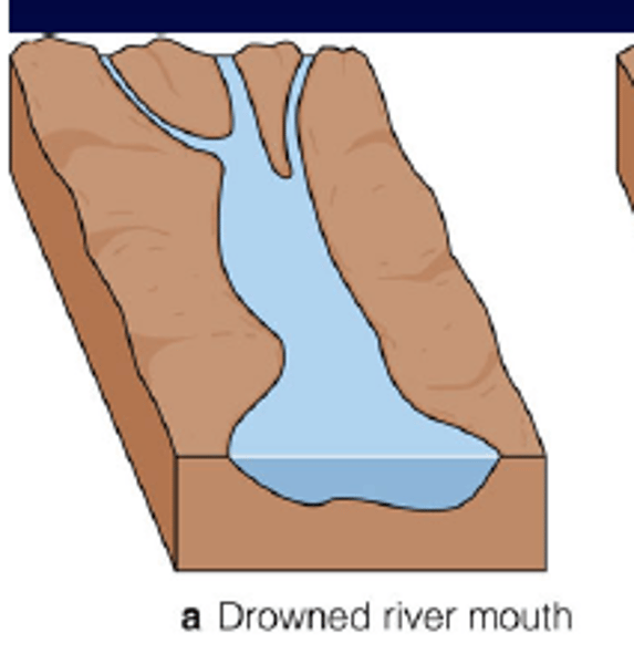
drowned river mouth estuary
former river valleys, now flooded with seawater
As glaciers receded and melted, sea levels rose and inundated low-lying river valleys.
Fjord estuary
often formed by tectonic forces, later modified by glaciers eroding valleys into deep, u shaped troughs
bar-built estuary
formed by accumulation of sediments in the shallow continental shelf
tectonic estuary
formed by tectonic movements
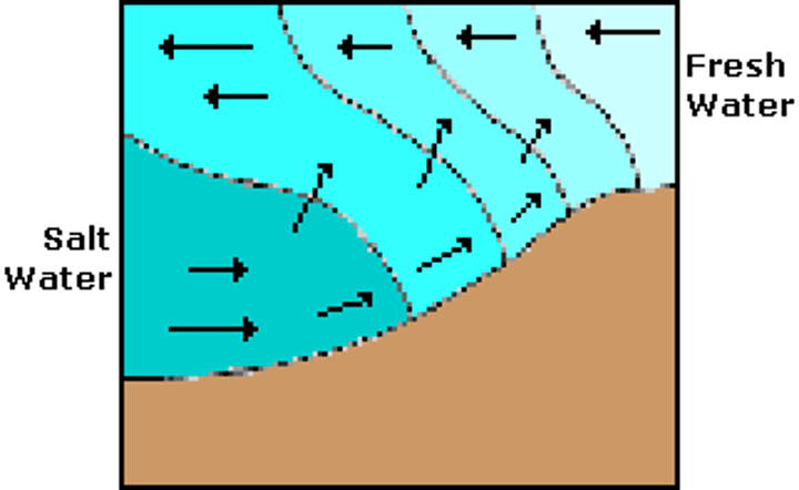
estuary circulation
most drowned river estuaries have a two layer water circulation
surface layer is low in salinity, deeper layer in high in salinity and nutrients
along the halocline active mixing takes place
partially mixed estuaries are "nutrient pumps"
salt marshes (tidal marshes)
develop along gently sloping shores
formed by accumulation of terrestrial sediment, which is trapped within the very dense root system of plants
temperate and higher latitude area, protected from wave energy
usually associated with estuaries, but also with protected beaches, and mud flats
formed by salt tolerant plants
very productive systems that support many aquatic and terrestrial organisms
subject to frequent flooding by tides
salt marshes (tidal marshes)
exhibit depletion just below the sediment surface
root system develops underground sending out rhizomes
below the root system appears the peat layer (compacts mass of partially decayed marsh grass and mineral sediment)
peat layer can be as deep as 10-20 meters
high levels of nitrogen fixation
the base of the food web is detritus and not primary producers
open ocean (pelagic zone)
consists of everything in the ocean outside of coastal areas
distribution of organisms based on temperature, light availability, and primary productivity
stable salinity (approx 35 ppt)
oligotrophic environment
divided into zones
covers nearly 70% of the planet surface
deep sea environment
earth's most uniform and largest community
no sunlight is available
water temp vary only slightly
much larger than related individuals in the shallow ocean
fragility
low metabolic rates
mostly soft biogenous sediments
physically stable
dependent on input of organic matter from above
hydrothermal vent communities
discovered in 1988 off the galapagos islands
a completely new ecosystem
located along the spreading ridges
water is heated and is rich in dissolved metals
chemosynthesis occurs
specialized communities form around whale falls
stepping stone theory
whale carcasses may provide "stepping stones" for organisms to drift from one carcass to the next until a new or newly active vent is reached
very diverse
a single rotting whale takes between 50-100 years to fully decompose
deep ocean brine pools
discovered in 1900 in the gulf of mexico
very extreme environment
brine often contains high concentrations of methane, providing energy to chemosynthetic animals that live near the pool
cold seeps (cold vent)
area of the ocean floor where hydrogen sulfide, methane, and other hydrocarbon-rich fluid seepage occurs, often in the form of a brine pool
cold does not mean that the temperature of the seepage is lower than that of the surrounding water
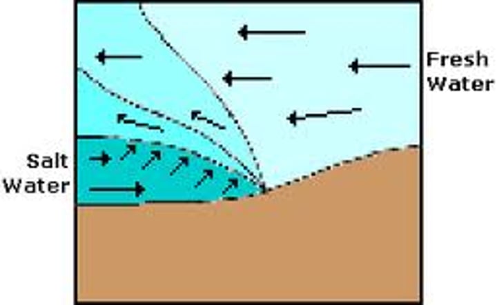
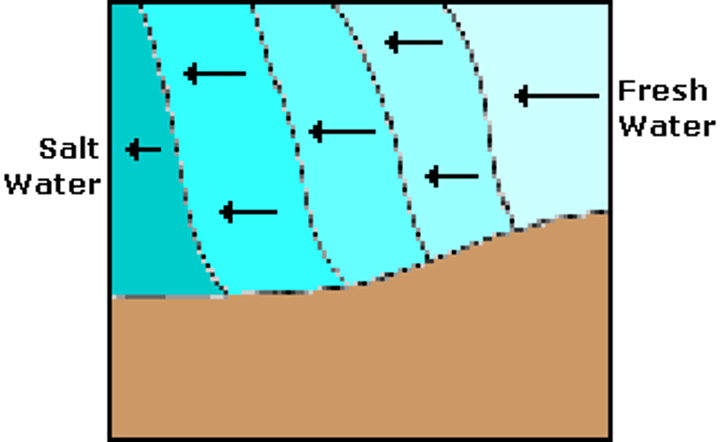
salt wedge estuary
rapid river flow and small tidal range cause an inclined wedge of seawater to form at the mouth.
well mixed estuary
slow river flow and tidal turbulence mix fresh and salt water in a regular pattern through most of its length.
partially mixed estuary
an influx of seawater occurs beneath a surface layer of fresh water flowing seaward. Mixing occurs along the junction.