Human Geo Unit 6 (ch. 15, 16, 17)
5.0(2)
Studied by 30 people0%Exam Mastery
Build your Mastery score
Supplemental Materials Call Kai
Card Sorting
1/72
Earn XP
Description and Tags
Last updated 5:10 AM on 3/14/23
Name | Mastery | Learn | Test | Matching | Spaced | Call with Kai | Chat |
|---|
No analytics yet
Send a link to your students to track their progress
73 Terms
1
New cards
urbanization
the process of the development of dense concentrations of people into settlements. increased rapidly during the Industrial Revolution with factories being built and people moving for jobs and more opportunities.
2
New cards
urban area
a city and its surrounding suburbs. definition varies by country (can depend on population, infrastructure, etc.)
3
New cards
metropolitan area
a city and its surrounding areas that are influenced economically and culturally by the city.
4
New cards
urban sprawl
when urban areas expand in an unplanned and uncontrolled way, covering large expanses of land in housing, commercial development, and roads. because of chaotic urban growth, infrastructure may not keep up.
5
New cards
livability
the combination of factors that make one place a better place to live than another (ex. housing, transportation, environment, health/public services, economic opportunities)
6
New cards
tract housing
multiple homes that are similar in design and building materials, that could be built quickly
7
New cards
gravity model
a model that predicts the interaction between two or more places; geographers derived the model from Newton’s law of universal gravitation
8
New cards
rank-size rule
an explanation for the size of cities within a country; states the second largest city will be half the size of the largest, third largest one-third size of largest, and so on. attempts to show pattern of functional interaction between population size and rank in urban systems. not exact, can be applied to some countries more than others
9
New cards
primate city
the largest city in a country, which far exceeds the next city in population size and importance. will cause the country it exists in to have few/no other large or medium-sized cities. indicates unbalanced level of development that can often be traced back to a city’s colonial past (ex. Dakar)
10
New cards
central place theory
a theory used to describe the spatial relationship between cities and their surrounding communities. published in 1933, describing central place which provides goods and services for surrounding areas (city large, central place around which smaller towns, villages, and hamlets are distributed.) observes consumer patterns & behavior. does not account for real-world geography, politics, or infrastructure.
11
New cards
threshold
the number of people needed to support a certain good or service
12
New cards
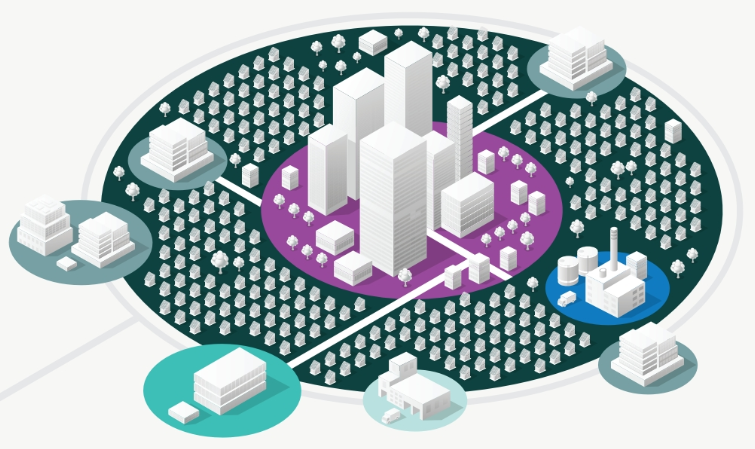
range
the distance that someone is willing to travel for a good or service (may be raised for high-order goods/services)
13
New cards
megacity
a city with a population of more than 10 million
14
New cards
metacity
a city with a population of more than 20 million
15
New cards
world/global cities
cities that have influence not only over their country or region, but also across the globe
16
New cards
concentric-zone model
a model of urban development depicting a city growing outward from a CBG in a series of concentric rings. developed from studying 1920s chicago.
17
New cards
sector model
a model of urban development depicting a city with wedge-shaped sectors and divisions emanating from the CBD, generally among transit routes. developed in 1939.
18
New cards
multiple-nuclei model
a model of urban development depicting a city where growth occurs around the progressive integration of multiple nodes, not around one CBD. proposed in 1945, not based on predictable patterns, but local context
19
New cards
node
the focal point of a region
20
New cards
galactic city model/peripheral model
a model of urban development depicting a city where economic activity has moved from the CBD toward loose coalitions of other urban areas and suburbs. proposed in the early 1980s. (airports out of city bounds)
21
New cards
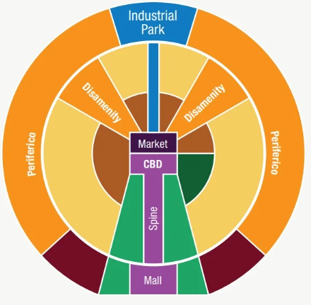
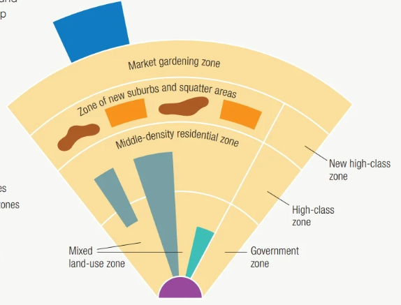
Latin American city model
a model of urban development depicting a city with a CBD, concentric rings, and sections stricken by poverty. developed in 1980. fails to differentiate between commercial and industrial uses, and is overly influenced by physical appearance
22
New cards
disamenity zones
high-poverty urban areas in disadvantaged locations containing steep slopes, flood-prone ground, rail lines, landfills, or industry
23
New cards
squatter settlements/shanty towns
an informal housing area beset with overcrowding and poverty that features temporary homes often made of wood scraps or metal sheeting. lacks basic infrastructure, with inhabitants that are not legally permitted to be on the land.
24
New cards
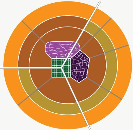
African city model
a model of urban development depicting a city with three CBDs, growing outward in a series of concentric rings. developed in 1962. (three CBDs: colonial powers in grid pattern, more traditional curbside commerce & 1-story retail stores, open air markets) out of date, doesn’t account for informal underground economies, or middle-class/wealthy areas, and places impoverished areas next to wealthy ones.
25
New cards
Southeast Asian city model
a model of urban development depicting a city oriented around a port and lacking a formal CBD, growing outward in concentric rings and along multiple nodes. created in 1967. has two formal zones that remain constant. now outdated, because cities in region have CBDs, and extended metropolitan regions
26
New cards
zoning
the process of dividing a city or urban area into zones within which only certain land uses are permitted (ex. manufacturing in industrial zones). can be further subdivided into specific categories (ex. specific kinds of housing units). set based on present and perceived future needs.
27
New cards
infilling
redevelopment that identifies and develops vacant parcels of land within previously built areas. often targets key transportation nodes or areas along transportation routes that are connected by bus service. can lead to increased housing potential, and increased ability of government and businesses to provide high quality service (more customers/users, or more tax revenue/profit)
28
New cards
ecological footprint
the impact of a person or community on the environment, expressed as the amount of land required to sustain their use of natural resources
29
New cards
livability
the sum of the factors that add up to a community’s quality of life, including the built and natural environments, economic prosperity, social stability and equity, and educational, cultural, and entertainment opportunities
30
New cards
mixed-use development (MUD)
a single planned development designed to include multiple uses, such as residential, retail, educational, recreational, industrial, and office spaces. can range in scale, but intended to increase residential densities and minimize the need for travel outside the development.
31
New cards
walkability
how safe, convenient, and efficient it is to walk in an urban environment.
32
New cards
transportation-oriented development
the creation of dense, walkable, pedestrian-oriented, mixed use communities centered around or located near a transit station
33
New cards
smart-growth policy
a policy implemented to create sustainable communities by placing development in convenient locations and designing it to be more efficient and environmentally responsible
34
New cards
mixed-use zoning
zoning that permits multiple land uses in the same space or structure
35
New cards
traditional zoning
zoning that creates separate zones based on land-use type or economic function such as various categories of residential (low, medium, and high density), commercial, or industrial
36
New cards
New Urbanism
a school of thought that promotes designing growth to limit the amount of urban sprawl and preserve nature and useable farmland. arose in reaction to sprawling cities of the mid-20th century. advocates for policies and design practices that support multiple transit options, preservation of historic buildings, and respect for local ecology
37
New cards
slow-growth cities
a city where planners have used smart growth policies to decrease the rate at which the city grows outward
38
New cards
urban growth boundary
a boundary that separates urban land uses from rural land uses by limiting how far a city can expand
39
New cards
greenbelt
a ring of park land, agricultural land, or other type of open space maintained around an urban area to limit sprawl. prohibits rural to urban land conversion within ring.
40
New cards
de facto segregation
segregation that results from residential settlement patterns rather than from prejudicial laws.
41
New cards
housing discrimination
an attempt to prevent a person from buying or renting a property because of that person’s race, social class, ethnicity, sexulity, religion, or other characteristic. (ex. deed restrictions, redlining, blockbusting)
42
New cards
redlining
when a loaning institution such as a bank refuses to offer home loans on the basis of a neighborhood’s racial or ethnic makeup. has its roots in 1930s policies.
43
New cards
blockbusting
a practice by real estate agents who would stir up concern that Black families would soon move into a neighborhood; the agents would convince White property owners to sell their houses at below-market prices.
44
New cards
zones of abandonment
areas that have been largely deserted due to lack of jobs, declines in land values, and falling demand.
45
New cards
filtering
the process of neighborhood change in which housing vacated by more affluent groups passes down the income scale to lower-income groups
46
New cards
inclusionary zoning laws
laws that create affordable housing by offering incentives for developers to set aside a minimum percentage of new housing construction to be allocated for low-income renters or buyers.
47
New cards
land tenure
the legal rights, as defined by a society, associated with owning land.
48
New cards
eminent domain
a government’s right to take privately owned property for public use or interest. called “compulsory acquisition” in India.
49
New cards
environmental injustice
the ways in which communities of color and poor people are more likely to be exposed to environmental burdens such as air pollution or contaminated water. (also called environmental racism) encompasses unequal protection under laws, government policies, and policy enforcement.
50
New cards
environmental justice
the idea that environmental laws and regulations should apply equally in all places and for all people, regardless of racial or ethnic composition.
51
New cards
urban renewal
the nationwide movement that developed in the 1950s and 60s when U.S. cities were given massive federal grants to tear down and clear out slums as a means of rebuilding their downtowns. (Housing Act of 1949, Housing Act of 1954, and the Federal Aid Highway Act of 1956)
52
New cards
regional planning
planning conducted at a regional scale that seeks to coordinate the development of housing, transportation, urban infrastructure, and economic activities
53
New cards
brownfields
abandoned and polluted industrial sites in central cities and suburbs
54
New cards
remediation
the removal of contamination within brownfields
55
New cards
site
a place’s absolute location, as well as its physical characteristics, such as the landforms, climate, and resources
56
New cards
situation
the location of a place in relation to other places or its surrounding features
57
New cards
edge city
a type of community located on the outskirts of a larger city (ex. commercial centers, retail complexes)
58
New cards
boomburb
a suburb that has grown rapidly into a large and sprawling city with more than 100,000 residents
59
New cards
exburb
a typically fast-growing community outside of or on the edge of a metropolitan area where the residents and community are closely connected to the central city and suburbs. often low density residential communities with wealthy estates or small rural towns.
60
New cards
suburbanization
the shifting of population from cities to surrounding suburbs. motivated by cheaper housing, more space, and lower crime rates.
61
New cards
gentrification
the renovations and improvements conforming to middle-class preferences
62
New cards
central business district (CBD) / market area
where a large amount of businesses are located, acts as a node for many urban developments.
63
New cards
public services
services offered by the government to provide security and protection for citizens and businesses.
64
New cards
consumer services
businesses that provide services primarily to individual consumers, including retail services and education, health, and leisure services.
65
New cards
economic base
the manufacturing and service activities performed by a basic sector
66
New cards
public housing
housing owned by the government.
67
New cards
zone in transition/transition zone
an urban area that is industrial and typically dominated by manufacturing facilities. close to CBD, and often surrounded by working-class residential areas.
68
New cards
megalopolis
an area formed when when urban expansion results in an overlap in development by cities in close proximity to one another, resulting in a network of high-density human settlements
69
New cards
urban hierarchy
a ranking of settlements (ex. hamlet, village, town, city, metropolis) according to their size and economic functions
70
New cards
basic industry
a city-forming industry
71
New cards
non-basic industry
a city-serving industry
72
New cards
retail services
services that provide goods for sale to consumers
73
New cards
business services
services that primarily meet the needs of other businesses, including professional, financial, and transportation services.