Subtropical Anticyclones (Unit 8) (pg. 105) - Climate & Weather
1/72
There's no tags or description
Looks like no tags are added yet.
Name | Mastery | Learn | Test | Matching | Spaced | Call with Kai |
|---|
No analytics yet
Send a link to your students to track their progress
73 Terms
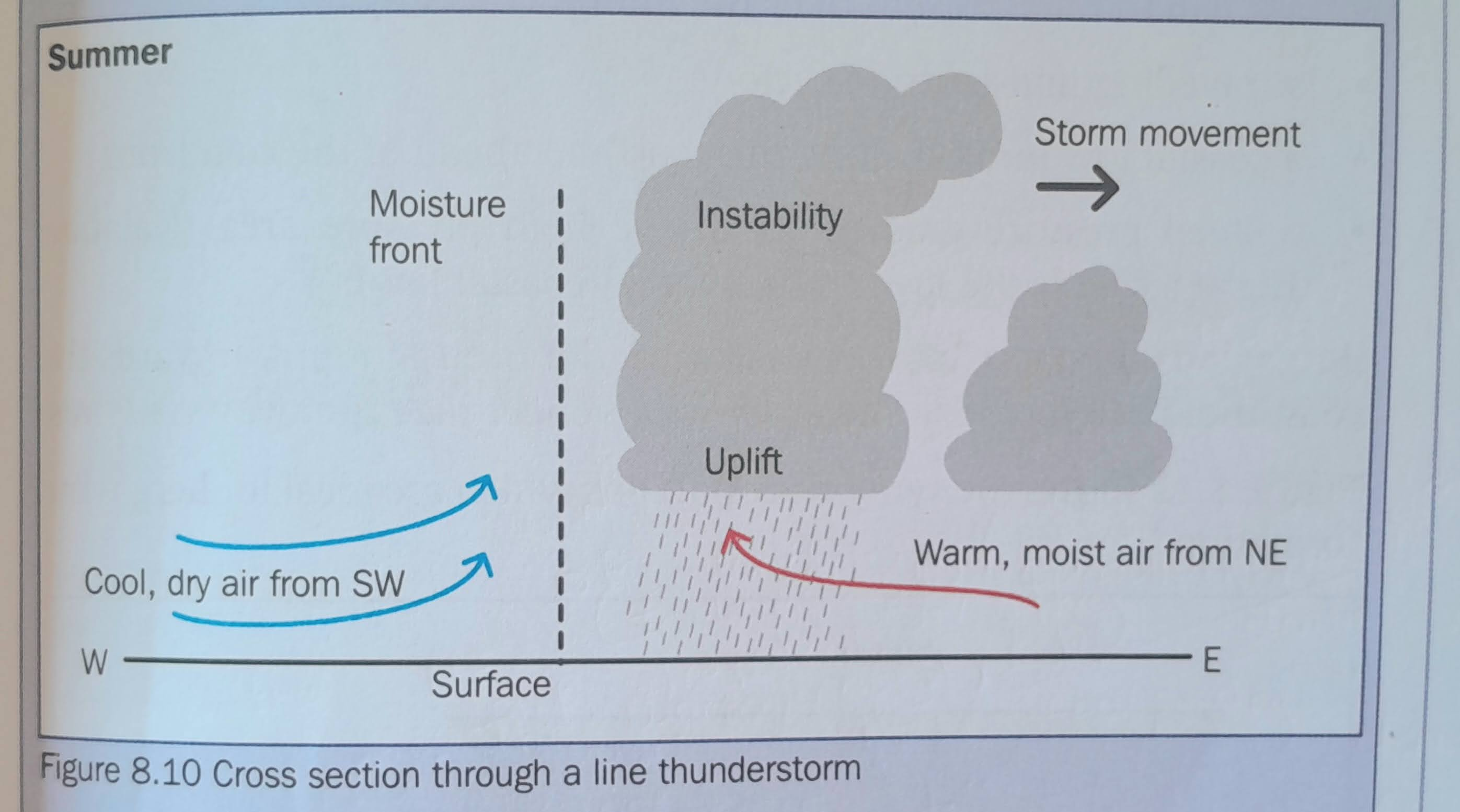
Label and draw a cros-section through a line thunderstorm
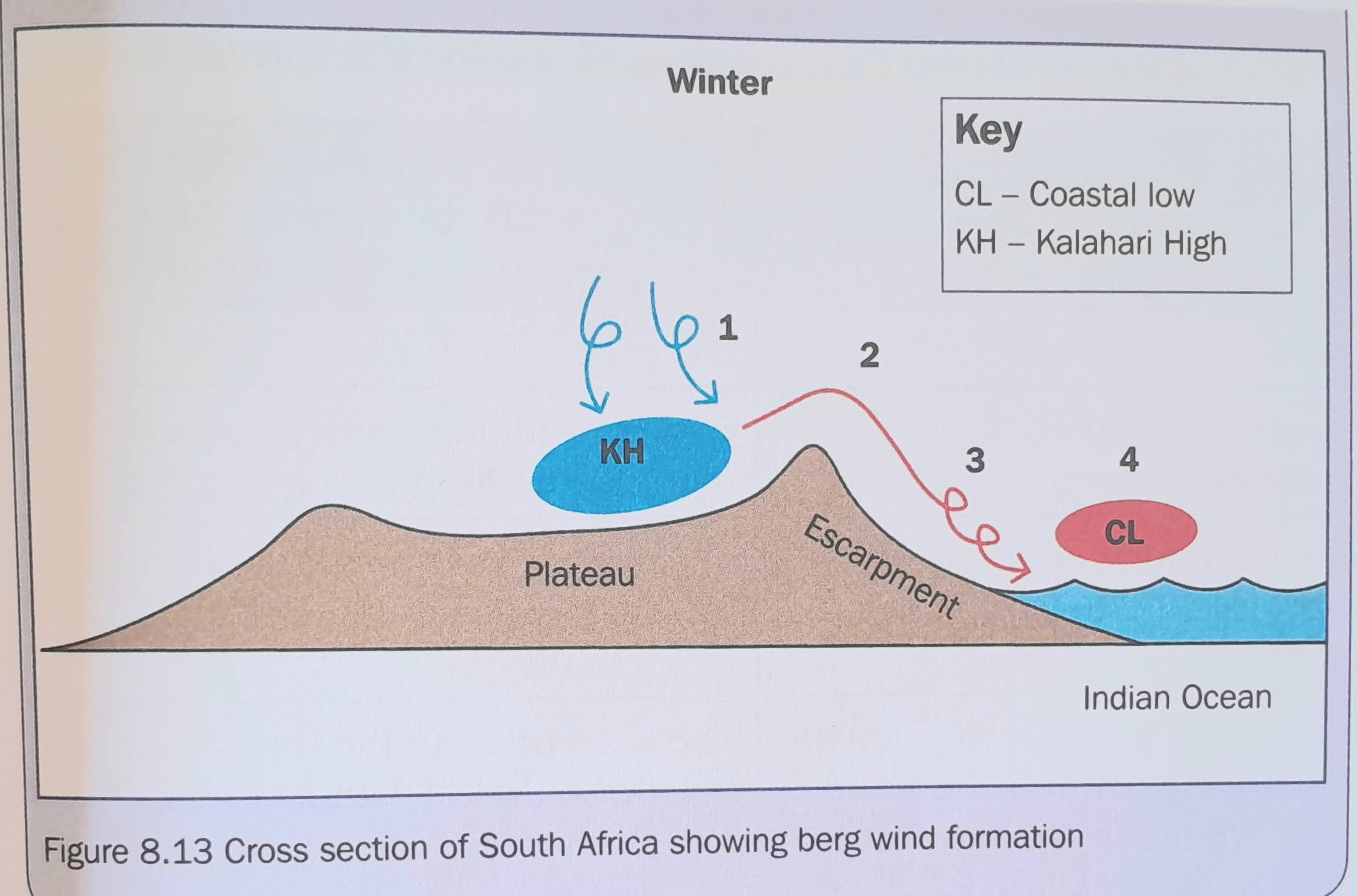
Draw a diagram showing berg wind formation
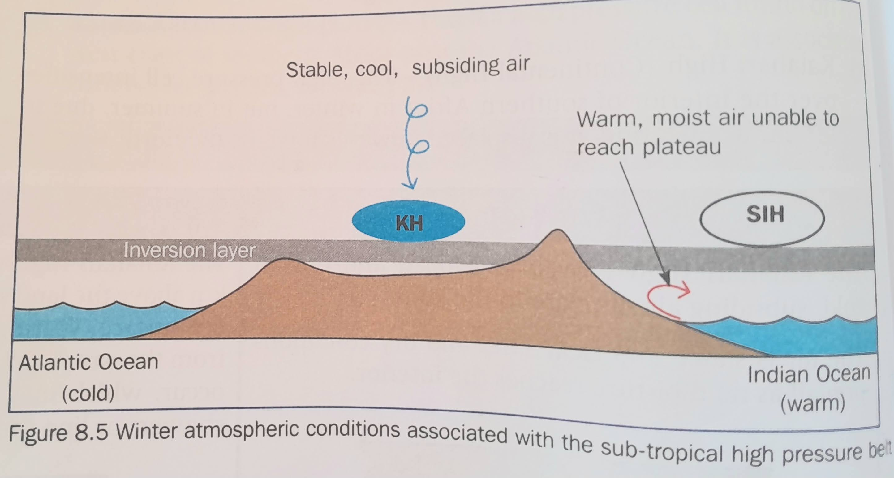
Draw a diagram illustrating the conditions associated with the sub-tropical high pressure belt in winter
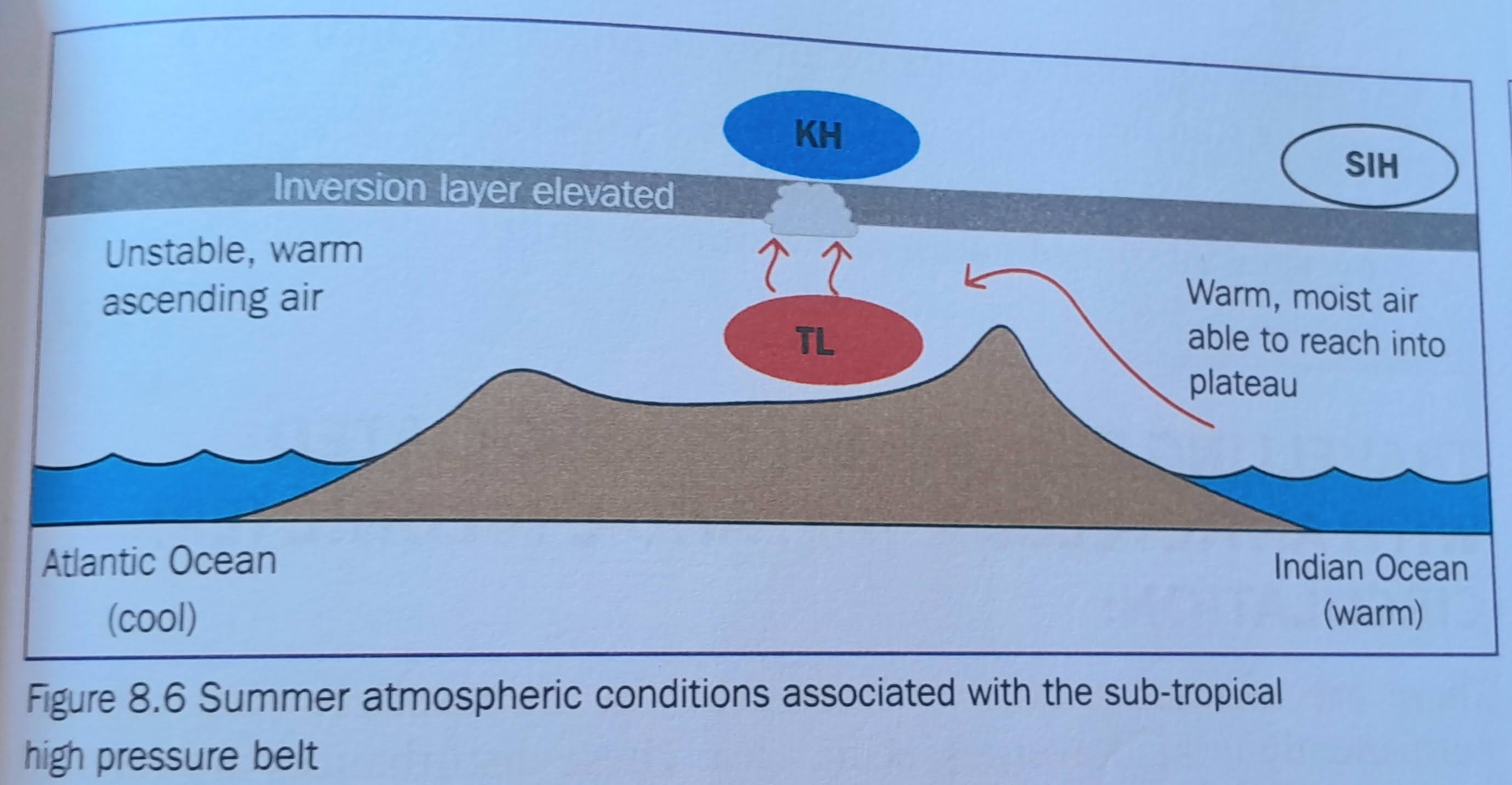
Draw a diagram illustrating the conditions associated with the sub-tropical high pressure belt in summer
what is an anticyclone often known as?
high pressure cell
what is a cyclone often known as?
low pressure cell
what is another name for the Kalahari High
Continental High
Name the three high pressure cells affecting South Africa.
South Atlantic High, South Indian High, and Kalahari (Continental) High.
what is another name for a thermal low?
heat low
Where are subtropical anticyclones located?
Along the subtropical high pressure belt at approximately 30°S.
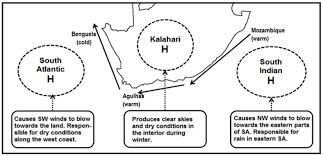
Where is the South Atlantic High located?
Over the Atlantic Ocean west of South Africa.
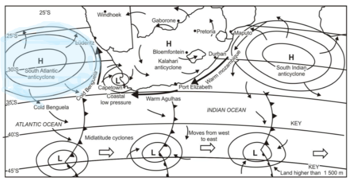
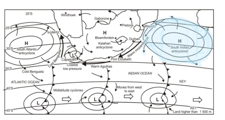
Where is the South Indian High located?
Over the Indian Ocean east of South Africa.
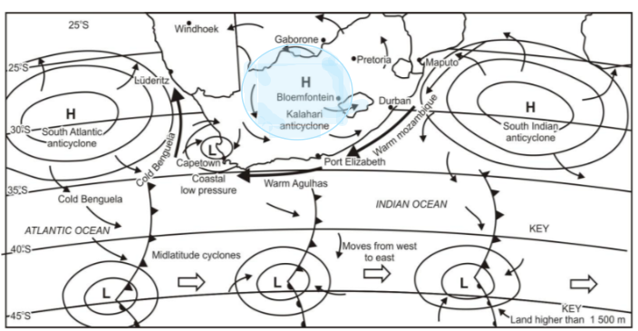
Where is the Kalahari High located?
Over the interior (central plateau) of South Africa.
Which high pressure cells occur all year?
South Atlantic High and South Indian High.
Which high pressure cell mainly affects South Africa in winter?
Kalahari High.
Why do high pressure cells shift position?
Due to seasonal shifting of pressure belts.
What happens to high pressure cells in winter?
They strengthen and move closer to land due to cool, stable, subsiding air.
What happens to high pressure cells in summer?
: They weaken and move to higher altitudes due to warm, unstable, rising air.
Direction of migration in winter?
Northwards.
Direction of migration in summer?
Southwards.
Why are high pressure cells stronger in winter?
Increased subsidence of cold, dense air.
Why are they weaker in summer?
Increased uplift and instability reduces subsidence.
Key characteristic of SAH? (4)
Cold, dense, subsiding air, strongest HP
Winter effect of SAH?
: Ridges behind mid-latitude cyclones, bringing clear weather from SW
Summer effect of SAH?
Moves south and may bring rainfall to south-east coast.
Why is SAH strong?
Cold Benguela Current enhances subsidence.
Key characteristic of SIH?
Warm, moist subtropical air.
Winter effect of SIH?
A: Strong blocking effect prevents moisture entering interior.
Summer effect of SIH?
: Allows warm, moist air into interior → rainfall.
Additional effect of SIH?
Can block mid-latitude cyclones and deflect tropical cyclones.
Winter condition of KH?
Strong, well-developed, close to surface.
Weather in winter due to KH? (3)
Dry, stable, clear skies.
Summer condition of KH?
Weakens and rises (~2 km above surface).
What forms at surface in summer?
Thermal (heat) low.
Result of KH weakening?
Moist air enters interior → rainfall.
Height of inversion layer in winter?
~1000 m (below plateau).
Height in summer?
~2000 m+ (above plateau).
Effect in winter?
Blocks moist air → dry interior.
Effect in summer?
Allows moist air → rainfall.
Why does inversion form?
Subsiding air heats adiabatically.
Why is interior dry in winter?
Inversion layer blocks moist air from Indian Ocean.
Why does summer rainfall occur?
Moist air rises, cools, condenses → cumulonimbus clouds.
Types of rainfall in summer interior?
Convectional and line thunderstorms.
: Why does Western Cape get winter rain?
Mid-latitude cyclones can reach land when HPs shift north.
When do line thunderstorms occur?
Summer.
What causes them?
Trough between thermal low and coastal low.
Air masses involved?
Warm moist air (NE) + cold dry air (SW).
What is the moisture front?
Boundary where these air masses meet.
Orientation of moisture front?
NW to SE.
Where does rain fall?
On the eastern side of the moisture front.
Why more rain on east side?
Higher dew point (more moisture).
Impacts of line thunderstorms? (3)
Flooding, hail damage, crop destruction.
Where do coastal lows form?
Along coastline (mainly west coast).
Movement pattern?
West → south → east coast.
Weather conditions?
Partly cloudy, light drizzle, unstable.
Role in weather systems?
Precedes cold fronts and contributes to berg winds.
When do berg winds occur?
Winter (April–October).
Required conditions? (3)
: Kalahari High + coastal low + mid-latitude cyclone.
Direction of wind?
: Interior → coast.
Why are berg winds hot?
Adiabatic heating as air descends escarpment.
Why are berg winds dry?
Moisture evaporates as air warms.
Characteristics of berg winds? (4)
: Hot, dry, strong, gusty winds.
: Impacts of berg winds? (4)
Veld fires, damage to crops, livestock loss, infrastructure damage.
Cause of cut-off low? (2)
Ridging of SAH + blocking by SIH.
Impact of cut-off lows?
Heavy rainfall and flooding over interior.
How to identify line thunderstorms on maps?
NW–SE cloud band with heavy cloud on eastern side.
Indicators of berg winds on synoptic maps? (3)
High pressure interior + coastal low + warm coastal temps
Winter synoptic pattern?
HPs shift north → cold fronts affect SA.
Summer synoptic pattern?
HPs shift south → block cold fronts.
What indicates rainfall likelihood?
High dew point temperature.
What indicates dry conditions?
Low dew point and clear skies.
Key role of subtropical anticyclones in South Africa?
They control seasonal weather patterns, rainfall distribution, and movement of air masses.