HRE - (midterm coverage_Q1 and Q2)
0.0(0)
Studied by 14 peopleCard Sorting
1/42
Earn XP
Description and Tags
Last updated 12:32 PM on 3/27/23
Name | Mastery | Learn | Test | Matching | Spaced | Call with Kai |
|---|
No analytics yet
Send a link to your students to track their progress
43 Terms
1
New cards
\
\
Local streets
\
Local streets
to access private property like residences, shops and industries. Traffic originates here or ends here
2
New cards
Collector streets
for collection and distribution of traffic through local streets in residential areas
3
New cards
Sub-arterial streets
similar to arterial roads but with less spacing.
4
New cards
Arterial streets
for connecting the central area to expressways.
5
New cards
Road
A convenient way over which vehicles may lawfully pass for going from one place to another.
6
New cards
Street
A road within a town or a residential locality with buildings on one or both sides.
7
New cards
Country road
Road connecting one place to another on the country-side.
8
New cards
Grid Iron Pattern
This is also known as rectangular or block pattern and is perhaps the simplest.
9
New cards
Radial Pattern
In this pattern, roads emanate from a central focal area, which may be a business center or an important public building. In order to ease the congestion in the focal area, ring roads are provided; there can be several such roads—inner, intermediate and outer—depending on the requirements of the traffic.
10
New cards
Hexagonal Pattern
The basic figure of the road network in this case is a ________; has at least one side common with an adjacent pattern
11
New cards
Economic Studies
Details of the existing facilities, their utility, distribution of the existing population in the area, population growth trends, existing products in the agricultural and industrial sectors, future trends of development in these sectors, existing communication and education facilities, and the per capita income are to be collected.
12
New cards
Financial Studies
source of income; Various financial aspects such as the sources of funding, estimated revenue from taxes on vehicles, toll tax, and indirect benefits of raising the living standards of the people due to the proposed road network are considered.
13
New cards
Traffic or road use studies
Details of the existing road facilities, traffic volume in vehicles per day, traffic flow patterns, classes of traffic such as passenger cars, busses and trucks, loads carried, average speeds, anticipated future trends of traffic growth, and other traffic-related studies are to be conducted.
14
New cards
Engineering studies
These include study of the topography, soil, road life and special problems, if any, relating to construction, drainage and maintenance.
15
New cards
1. Population served by the road
2. Productivity served by the road network
Factors for obtaining the utility per length of road are:
16
New cards
Route planning phase
is the time to evaluate environmental and economic tradeoffs and should set the stage for the remainder of the road development process.
17
New cards
alignment
The laying out of the centre line of a proposed highway on the ground is called its ‘________’.
18
New cards
**Safety**
should be the primary consideration for road users; the stability of natural slopes and man-made slopes for embankments and cuttings should be ensured to prevent possible accidents.
19
New cards
**Directness**
The aligned route between end points should be as direct as possible and result in the minimum possible length under the circumstances.
20
New cards
**Map Study**
Topographic maps are available with 15 to 30 meters contour intervals. Valleys, ponds or lakes etc. can be avoided and approximate position of bridges etc. can be planned.
21
New cards
**Preliminary Survey**
This is carried out to collect all the physical information which are necessary in connection with the proposed highway alignment.
22
New cards
**Final location and detailed survey**
The center line of road finalized is translated on the ground during location survey. Detailed survey is done to fix temporary benchmark and leveling work is used for drainage and earthwork calculations
23
New cards
Ease of Construction, Maintenance, & Operation
The alignment should be such that it is easy to construct, maintain and operate the Highway. The curves and gradient should be easy.
24
New cards
6%
If snow and ice are factors, the superelevation rate should not exceed______ and should not further reduced on grades to accommodate slow truck traffic.
25
New cards
32 kph
Superelevation should not be used for design speed less than _________.
26
New cards
15 meter
A minimum centerline radius of curvature for roads should be _________ except for some recreation and administrative roads.
27
New cards
24 kph
For low volume roads with design speed of ______ or less, horizontal alignment that approximates the geometric requirements of circular curves and tangents may be used.
28
New cards
8%
The most desirable combination of grade and other design elements should be determined early in the road location phase with additional caution exercised when grades exceed _______.
29
New cards
10%
Vertical alignment, or grade; is critical concern because of its potential for environmental damage and becomes increasingly important for grades exceeding _______.
30
New cards
Expressways
For movement of heavy volume of traffic.
31
New cards
Design Speed
Is defined as a selected rate of travel used to determine the various geometric features of the roadway.
32
New cards
Design Vehicle
Is a selected motor vehicle whose weight, dimensions, and operating characteristics are used to establish highway design controls to accommodate vehicles of a designated type.
33
New cards
Sight Distance
Is the roadway ahead that is visible to the driver.
34
New cards
Stopping Sight Distance
Is the distance ahead that a motorist should be able to see so that the vehicle can be brought safely to a stop short of an obstruction or foreign object on the road.
35
New cards
Shoulder
Is the portion of the roadway contiguous with the travelled way for accommodation of stopped vehicles, for emergency use, and for lateral support of subbase, base and surface courses.
36
New cards
Guard Rails
Are longitudinal barriers placed on the outside of sharp curves and at sections with high fills. Their main function is to restrain and redirect errant vehicles and prevent them from leaving the roadway.
37
New cards
4 ft.
Sidewalks should have a minimum clear width of _______ in residential areas.
38
New cards
4 — 8 ft.
Sidewalks should have a width ranging _______ in commercial areas.
39
New cards
Median
Is the section of a divided highway that separates the lanes in opposing directions.
40
New cards
Curbs
Are raised structures made of either Portland cement concrete or bituminous concrete that are used mainly on urban highways to delineate pavement edges and pedestrian walkways
41
New cards
Cutting
Is the process of excavating earth material from a work location to achieve the desired topography.
42
New cards
Filling
Is the process of moving the excavated material or additional earth material to a work location to achieve the desired topography.
43
New cards
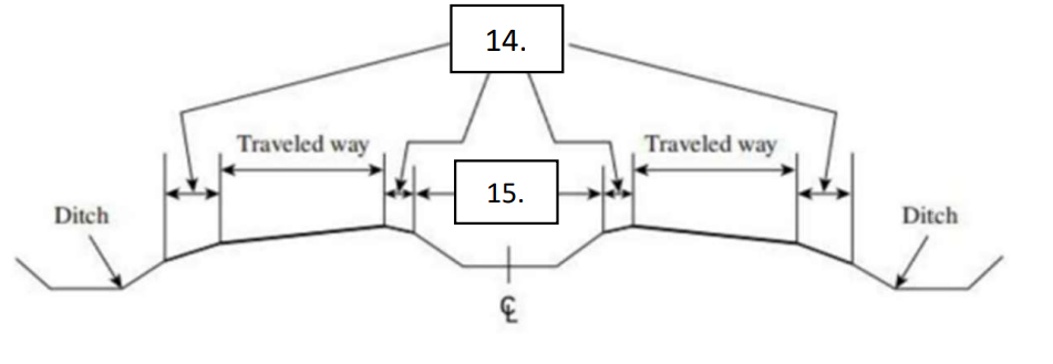
shoulder
Median
Median
Name the following: