Geography Unit 2
1/133
Earn XP
Description and Tags
Name | Mastery | Learn | Test | Matching | Spaced |
|---|
No study sessions yet.
134 Terms
The Earth's crust is composed of 4 major layers. They are...
• the inner core
• the outer core
• the mantle
• the crust (what we live on)
What is the Earth's crust?
The Earth's crust is the thinnest and outermost layer of the Earth.
It is the layer we live on.
It is made up of the continental crust and the oceanic crust.
How do we know the Earth's composition?
Geological prospecting: mines, boreholes, field research
Mapping: ground, air, sea and satellite.
Who was Alfred Wegener (1880-1930)?
- He was a German meteorologist and he theorized that the continents' coastlines seemed to have much in common (puzzle)
- that there used to be a supercontinent called 'Pangaea'.
- that this landmass split up approx. 200 million years ago, due to the internal pressures of the earth.
What was Pangea?
a supercontinent that formed 300 million years ago
What is continental drift?
the gradual movement of the continents across the earth's surface through geological time.
What were the 4 arguments that Wagner based his theory on?
-Terrestrial fossils (of animals and plants) were found on both continents, which was only possible if the continents were previously connected.
-The coasts of Africa and South America seemed to intertwine and fit like a puzzle together.
-The Age and Structure of the Mountains on both sides of the Atlantic have similar composition.
-Traces of ice sheets have been found in places where it is very warm today showing a change in latitude.
Who was Tuzo Wilson?
He was a Canadian geophysicist from U of T and he came up with the idea of plate tectonics.
-The world is made up of a series of zones or 'plates'
created by internal pressures in the mantle
-Continents moved on plates or large sections of crust, floating on a less dense upper mantle.
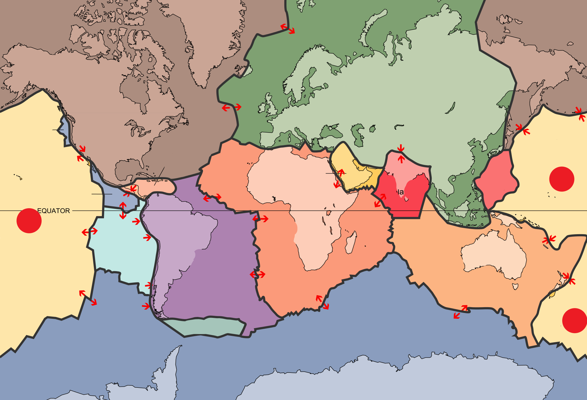
What are the 3 type of boundaries in plate tectonics?
- divergent
- convergent
- transform
What is the definition of DISASTER?
a sudden event, such as an accident or a natural catastrophe, that causes great damage or loss of life.
What is the definition of HAZARD?
A hazard is a present condition, event, object, or circumstance that could lead to or contribute to an unplanned or undesired event such as an accident.
What is a DISATER RISK REDUCTION?
-reducing disaster risks through systematic efforts to analyze and manage the causal factors of disasters, including through reduced exposure to hazards, lessened vulnerability of people and property, wise management of land and the environment, and improved preparedness for adverse events.
What is preparedness?
The knowledge and capacities developed by governments, professional response and recovery organizations, communities and individuals to effectively anticipate, respond to, and recover from, the impacts of likely, imminent or current hazard events or conditions.
Where is the Ring of Fire located?
around the margins of the Pacific Ocean
What are some of the advantages of living near a volcano?
- excellent rich soil that is good for growing food
- geothermal power is often a cheap and clean source of power - e.g. Iceland
-Tourism is a strong pull - landscape, huge waterfalls, wildlife, climbing and hiking and location.
- Close to the coast - the climate is good, fishing and farming are easy.
-Transport links tend to be good and the flat land near the coast is a good place to build towns and cities.
There are 3 types of rock. They are...
-igneous
-Sedimentary
-Metamorphic
What is a metamorphic rock and give an example?
Any type of rock that experiences extreme heat and pressure and changes into different rock.
ex:
marble
slate
gneiss
What is a sedimentary rock and give an example?
Rock formed by weathering, erosion, deposition, and cementation and compaction.
ex:
sandstone
limestone
shale
What is igneous rock and give an example?
Rock formed from melting rock turning into magma then cooling.
ex:
Granite
Obsidian
Basalt
Pumice
What is a volcanologist?
- a geologist that specializes in volcanoes
What is weather?
The state of the atmosphere at a given time and place.
- can be defined as: day-to-day characteristics of atmospheric conditions (i.e. amount of precipitation, sunshine or wind).
What is climate?
Climate is the weather conditions of a place averaged over a long period of time.
What are the 4 basic facts that explain why Canada's climate has so much variety?
-Canada extends for a great distance from north & south (latitude)
-different elevations (mountains, flats, valleys) produce different climate conditions.
-Coastal (maritime) regions have different climates than inland (continental) regions.
-Wind and pressure systems move weather conditions from one part of the country to another.
What are the 6 factors that affect climate?
LOWER-N,
-Latitude
-Ocean Currents
-Wind and air masses
-Elevation
-Relief
-Near water
What is a climate graph?
a climate graph shows the average rainfall and tempatures in a specific area
Maritime climate characteristics
warm summers; mild winters; high rainfall; near large bodies of water;
Ppt more than 1000mm/yr
temperature range is less than 25 degrees Celsius
e.g. Prince Edward Island and the rest of the Maritimes (Atlantic Ocean), Vancouver, B.C. (Pacific Ocean), Toronto, Ontario (because of Lake Ontario).
Continental climate has
Cold winters and hot summers
larger temperature range - 25 degrees Celsius or more
Ppt less than 1000mm/yr
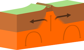
Give the definition and an example of a divergent plate boundary.
Divergent Plate Boundary: where tectonic plates are moving away from each other
ex:
North American and Eurasian Plate boundaries
South American and African Plate boundaries
Australian and Antarctic Plate boundaries
African and Arabian Plate boundaries
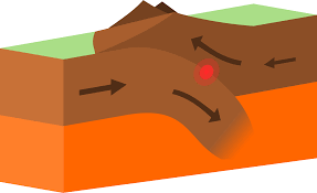
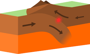
Give the definition and an example of a convergent plate boundary.
Convergent Plate Boundary: where tectonic plates are moving toward each other
Ex:
Pacific & Australian Plate boundaries
Indian & Eurasian Plate boundaries
Give the definition and an example of a transform plate boundary.
Transform Plate Boundary: where tectonic plates are sliding in opposite directions from each other
Ex:
Pacific and North American Plate boundaries
Name one of the 6 factors that affect climate that starts with the letter L and what it means?
-Latitude
Latitude:
The proximity (how close) a place is to the equator. (0o = equator, 90o = Poles)
Different latitudes receive different amounts of solar energy
Solar energy directly affects the temperature and wind patterns of a region
Name one of the 6 factors that affect climate that starts with the letter O and what it means?
Ocean Currents
Ocean Currents: Rivers of flowing water found in the world's oceans.
Ocean currents can either warm up or cool down a region depending on their source
The Gulf Stream carries heat into Europe
The California current keeps the west coast relatively cool
Warm water flows from the equator towards the poles whereas cold polar water flows from the poles towards the equator
Name one of the 6 factors that affect climate that starts with the letter W and what it means?
Wind and air masses
Wind Direction: the location from which an air mass is flowing. Wind flowing from the arctic to the south is considered a polar (cold) wind. Wind flowing from the west to east is called a westerly wind.
Continental (c): Dry air originating on land
Maritime (m): Wet air originating on water
Tropical (T): Warm air from the tropics/equator
Polar (P): Cold air from the poles (arctic)
Name one of the 6 factors that affect climate that starts with the letter E and what it means?
Elevation
Elevation: how high/low a place is compared to sea level (0ft).
Temperature changes with elevation
The higher the elevation, the colder the climate
As temperature changes the chance of precipitation changes as well.
Rising air is more likely to condense.
Falling air warms up and holds more water vapour.
Name one of the 6 factors that affect climate that starts with the letter R and what it means?
Relief
Relief: How the shape of the land can impact the climate of a region. Mountains can cause differences in rainfall. Orographic precipitation occurs when air is forced up a mountain side by wind.
Name one of the 6 factors that affect climate that starts with the letter N and what it means?
Near Water
Near Water:
Water warms more slowly than land
Water also give off heat more slowly
Water holds heat longer than land
Proximity to oceans and lakes can moderate land temperatures
Locations near water will be warmer during the winter and cooler during the summer
What are the three plate boundaries?
Convergent, transform, and divergent.
what's a convergent plate boundary?
A convergent plate boundary is a type of boundary where two plates collide and move towards each other. This collision can result in mountain ranges, and volcanic activity, trench if underwater.
what's a transform plate boundary
A transform plate boundary is a type of plate boundary where two tectonic plates slide past each other horizontally. This movement can result in earthquakes.
what's a divergent plate boundary
A divergent plate boundary is a tectonic boundary where two plates move away from each other. This movement creates a gap or rift between the plates. Makes mid-ocean ridges and rift valleys on land.
Fill in the blanks: In 1915, ___ hypothesized that ___ years ago, there was a giant landmass which he named ___.
Alfred Wegener, 200 million, Pangaea.
What’s Alfred Wegener’s evidence for proving that Pangaea was real?
Found the same fossils on two different continents (meaning they were, at one point, close enough to have similar species.) Age and structure of the rocks of the Appalachians (NE Canada) and the Caledonians (N.Eu) were similar. Many continents fit together like puzzle. Ice covered areas that are too warm in today’s earth to be covered in ice which might mean they were at different latitudes.
In 1968, ___ invented ___. Earth was covered in ___. Named all the __ and indicated the direction they were moving.
Tuzo Wilson, plate tectonics, plates, plates
Name this plate boundary.
Convergent.
Name this plate boundary.
Convergent
Name this plate boundary.
Divergent.
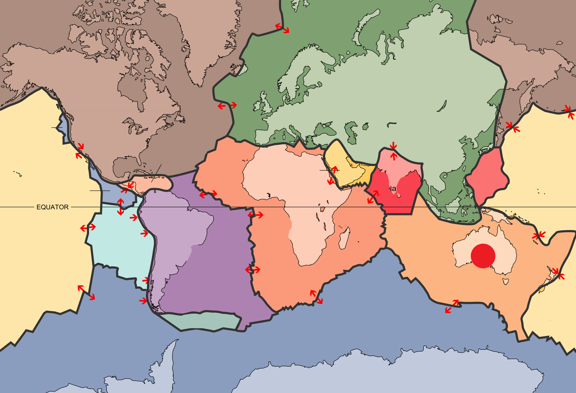
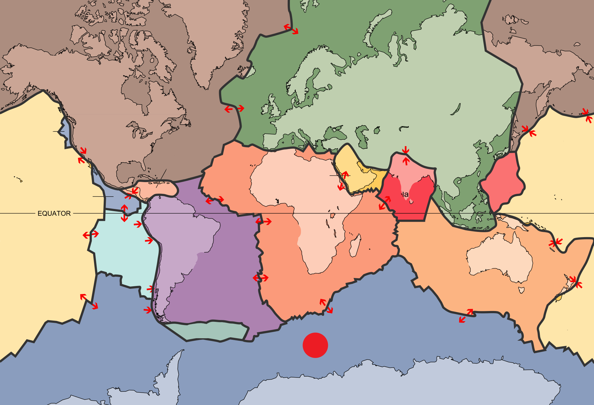
What two plates are causing the chain of volcanoes in South America?
South American and Nazca Plate.
What’s happening to the Atlantic Ocean?
A ridge is forming in the Mid-Atlantic Ocean because of the South American and the Nazca plate colliding.

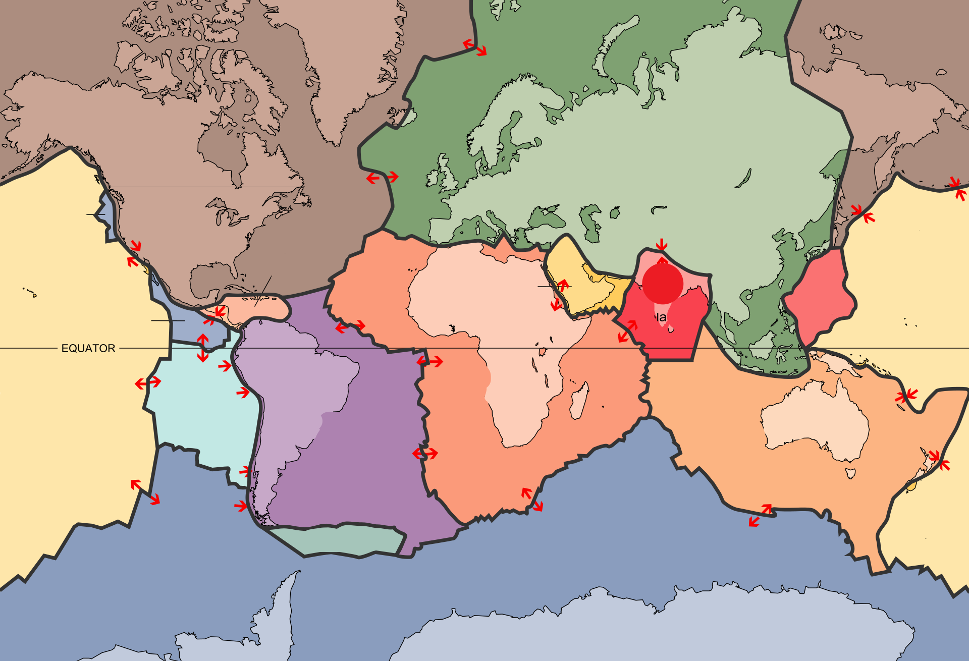
What’s this plate called?
Eurasian plate.

What’s this plate called?
North American Plate.
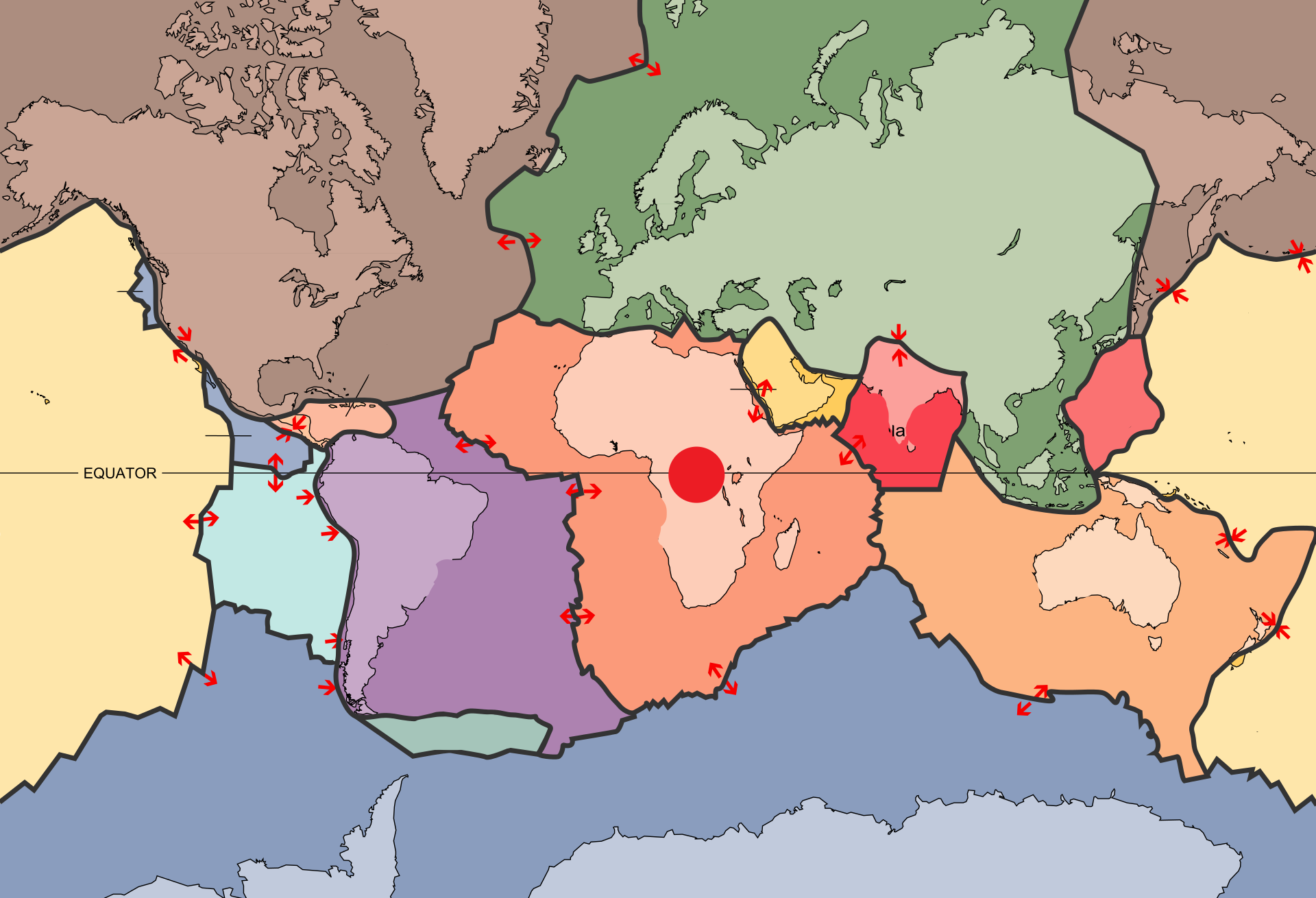
What’s this plate called?
African Plate.
What’s this plate called?
Pacific Plate.
What’s this plate called?
Australian Plate.

What’s this plate called?
Filipino Plate.
What’s this plate called?
Indian Plate.

What’s this plate called?
Arabian plate.

What’s this plate called?
South American Plate.
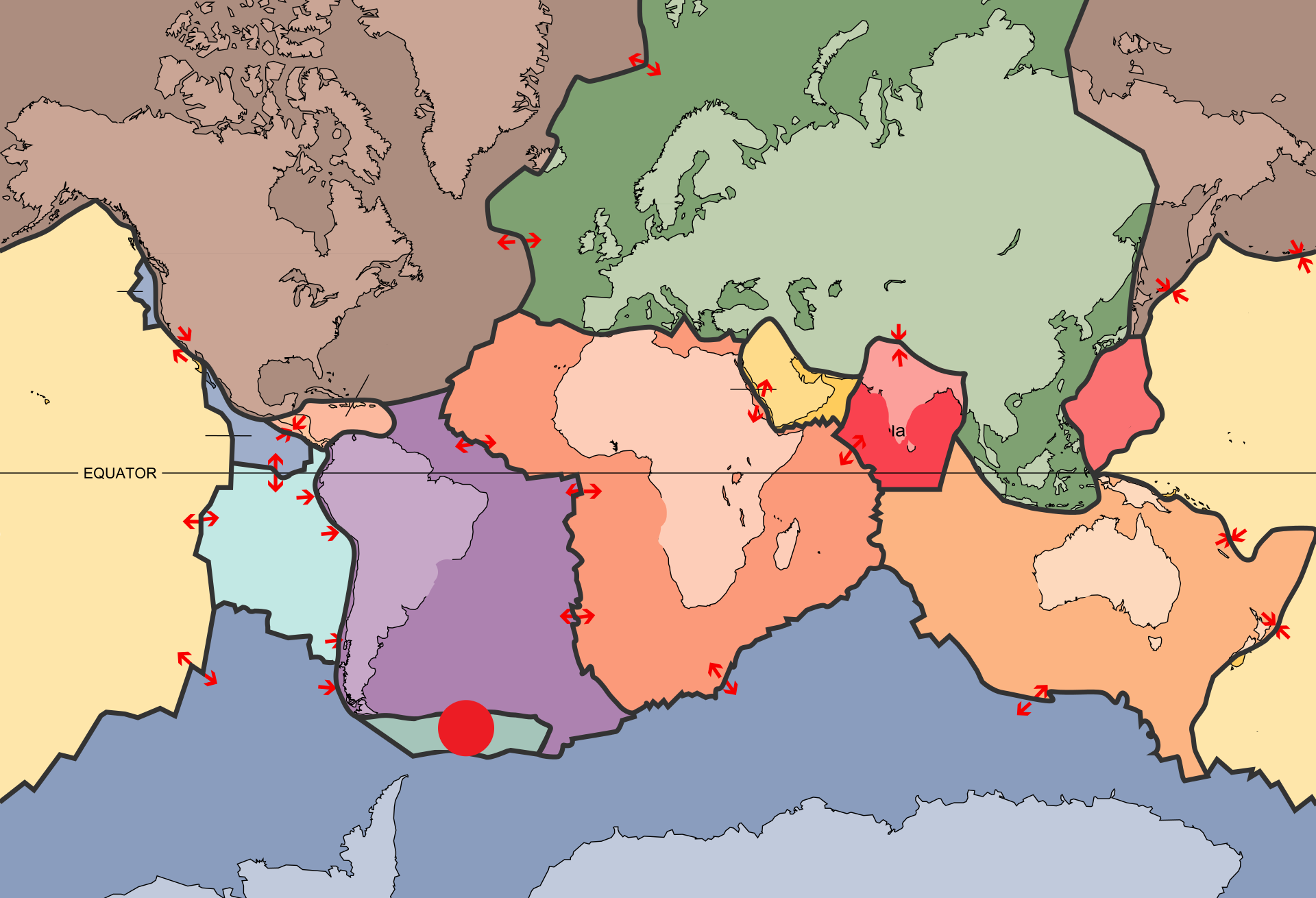
What’s this plate called?
Scotia plate.

What’s this plate called?
Caribbean plate
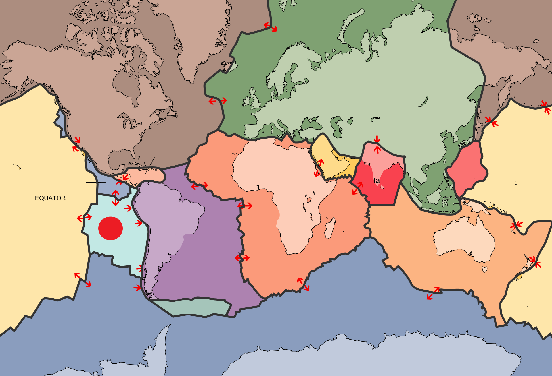
What’s this plate called?
Nazca plate
What’s this plate called?
Antarctic plate

What’s this plate called?
Cocos plate

What’s this plate called?
Juan de Fuca plate
Generally, how many cm do continents move apart every year?
2 cm
What’s the main force that destroys mountains?
Water
Where do scientists believe life may have originated on our planet?
Hot springs or bottom of the ocean.
Give examples of locations where divergent, convergent, and transforming plates occur.
Divergent: mid-ocean oceanic ridges, some on land. Convergent: locations where crust and mantle plates are moving towrd one anth. Transforming: where 2 tect plates slide past each other horiz.
what's the ring of fire?
A major area in the rim of the Pacific Ocean where a large number of earthquakes and volcanic eruptions occur. It is characterized by a horseshoe-shaped ring of intense seismic activity and is home to 75% of the world's active volcanoes.
2 examples of c,d,t plates.
C: Pacific and NA
D: Australian and Antarctic
T: Pacific and NA.
why do some people live in hazardous areas
they have their benefits (prices might be cheaper, soil might be very fertile, etc.)
How does the lava lake found in the Erta Ale volcano in Ethiopia help us understand tectonic plates?
Just as the tectonic plates move from the magma below them, the lava lake shows the exact movement with the ‘lava crusts‘, but speeded up.
How was the Earth formed?
At first, Earth was just pieces of rock, colliding into each other ad they circled the Sun. These violent impacts generated loads of heat and delivered lots of radioactive material to the center. When the surface cooled, the heat and radioactivity became trapped inside Earth’s hot core.
How deep is the magma in Iceland?
600 km
How did Earth manage to pull itself out from the snowball period 700 million years ago?
Despite Earth being covered in ice, volcanoes were still erupting. The CO2 they released thickened over the years, and the planet accumulate enough heat to fight back.
how can we prepare for a tsunami?
To prepare for a tsunami, you should: stay informed at all times, create an emergency plan, have an emergency kit, identify safe zones for important buildings and shelter, be thoroughly educated, practice, have defense set up, and make sure your building can withstand the force of a tsunami.
how can we prepare for a earthquake?
To prepare for an earthquake, you should: have an emergency plan, have an emergency kit, secure furniture, educate yourself, practice, stay informed, and make sure your building can withstand the force of an earthquake.
What are the 7 different landform/physiographic regions Canada is made up of?
Cordillera, Interior Plains, Canadian Shield, Arctic and Subarctic, Hudson Bay Lowlands, Great Lakes-St. Lawrence Lowlands, Appalachian Region.
How has ice shaped our world?
Ice, one of the most powerful forces on Earth, has carved the landscape, created diverse terrains, changed the climate, unleashed terrible natural disasters, and shaped the lifestyle of all humans.
What are glaciers made of?
Snow
What happens to the snow as more layers are built up every year?
As snow builds up every year, they compress together. The air is forced out as they compress, making them extremely hard. Yearly, snow builds up on each other in layers, and it is possible to see where dirt marks left from last summer. The further the layers go, the more complex, pressurized, and hard the snow becomes. The purest and hardest snow is at the bottom of all the layers.
How long does the average ice age last?
A few million years.
What has formed “El Capitan” in Yosemite National Park?
Ice
Why do icebergs float?
Icebergs float because solid ice expands when it freezes, becoming less dense than liquid water.
How does the reflection of ice affect Earth’s climate?
Ice does not just reflect light but heat as well. When it does, the heat spreads out all around it. By doing so, ice can affect the climate of everything around it.
How have the past ice ages potentially affected human evolution?
The ice age ended as more of the sun’s energy was reflected from the ice. Extreme conditions started to spread all around the world. Only those who were able to adapt would survive. The Neanderthals were almost forced to evolve, which is when modern humans began to emerge.
How much would the world’s sea level rise if all of Greenland’s ice melted?
7 m, flooding most of the highly-populated regions of the world.
What’s climate?
Weather conditions of a place averaged over a long period of time.
What’s weather?
Combination of temp, prec, cloud cover and winds experienced daily.
Why does Canada have different climates in different places?
Extends for a great distance from N to S. Different elevations. Coastal regions diff climates than inland regions. Wind and pressure systems move weather conditions around.
What’s continental climate?
Inland, not close to big bodies of water, less annual prec than 1000m. Pyramid shaped pattern in a climate graph: high in summer bcs of high heat and evaporation. Large annual temp range bcs no moderating effect of a body of water. Temp rand => 25 degrees C.
What’s maritime climate?
Close to big bodies of water. High annual prec >1000mm. U shaped ptn, high in winter bcs cyclonic storms. low annual temp range bcs of effects of body of water. Temp range <25 degrees C.
What’s growing season?
When temp is =>6 C.
In a climate graph, is temp left or right?
left
How to remember factors affecting temp?
LOWERN
L in LOWERN?
Latitude. Proximity a place is to equator. Diff lat=diff amount of solar energy. Think of flashlight.
O in LOWERN?
Ocean Currents. Can warm/cool a region. Gulf stream carries heat into Europe. California current keeps west coast relatively cool. Warm water flows from equator toward poles. Cold water goes from poles to equator.
W in LOWERN?
Wind Direction. Location from which air mass is flowing. Arctic to south is cold. West to east is westerly wind. Continental wind is dry and from land. Maritime is wet from water. Tropical warm, from tropics or equator. polar is cold, from poles.
E in LOWERN?
Elevation. How high/low a place is compared to sea level. Temp changes with elevation. higher elevation = colder climate. Temp changes = more chance of prec. Rising air is more like to condense. Falling air wars up and holds more water vapour.
R in LOWERN?
Relief. How the shape of the land can impact the climate of a region. Mountains can cause differences in rainfall. Orographic prec occurs when air is forced up a mountains side by wind.
N in LOWERN?
Near Water. Water warms more slowly than land, and gives off heat slowly, and holds heat longer. Proximity to lakes and oceans can moderate land temperatures. Locations near water have warmer winters and cooler summers. Small temp range.