2 - Coastal environments
1/95
Earn XP
Description and Tags
Name | Mastery | Learn | Test | Matching | Spaced |
|---|
No study sessions yet.
96 Terms
Waves
Marine processes
Erode, transport + deposit material
Formed by winds blowing over surface of sea
Factors affecting wave strength
Wind strength - stronger wind = bigger waves
Wind duration - longer period of time = bigger waves
Fetch (distance of open sea that wind travels across) - longer fetch = bigger waves
What causes a wave to break?
Wave moves into shallow water
Base of wave has increased friction, causing it to slow down
Top of wave continues at same speed
Wave becomes unstable and collapses
Swash
Incoming water pushed up the beach, at the same angle as the waves (transfers energy up the beach)
Backwash
Water moving back down beach, perpendicular to beach due to gravity (returns energy down beach)
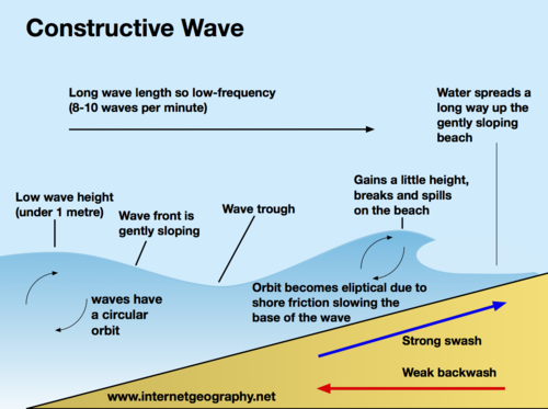
Constructive wave
Low energy
Strong swash + weak backwash
Causes sediment to be deposited on beach
Low frequency, 6-8 per min
Low wave height but long wavelength
Deposit sand so they create flat beaches
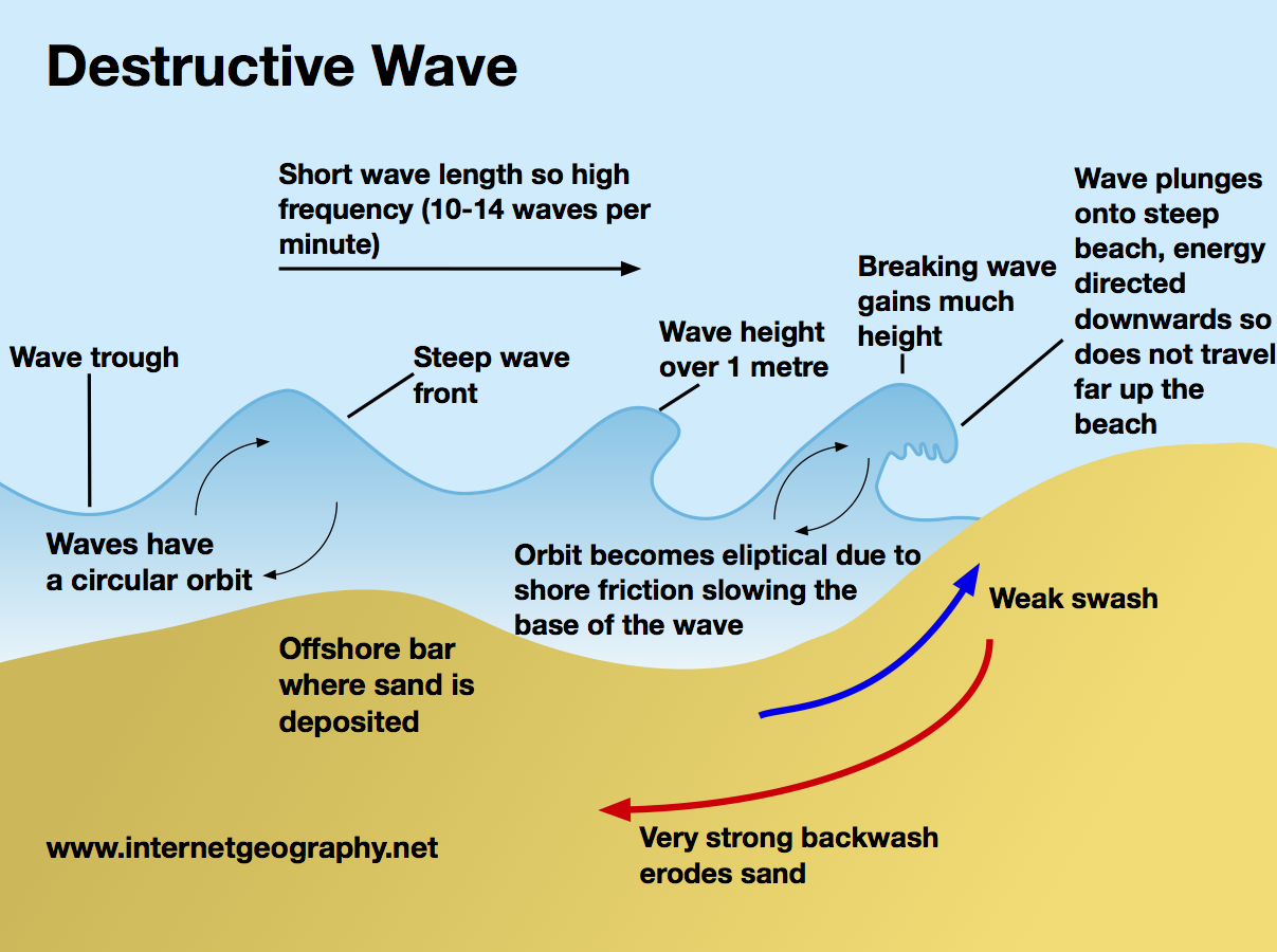
Destructive wave
Lots of energy
Strong backwash
Causes coast to be eroded away
High frequency, 10-12 per min
High wave height
Can remove sand from beaches making them steep
Transportation
Material in sea arrives from many sources:
Eroded from cliffs
Transported by LSD along coastline
Brought inland from offshore by constructive waves
Carried to coastline by river
Traction
Large, heavy material dragged along sea floor
Saltation
Smaller material is bounced along sea floor
Suspension
Fine material is held in water
Solution
Dissolved material carried in water
Longshore Drift (LSD)
Main process of deposition + transportation along coast
Influenced by prevailing wind, waves approach beach at an angle
As waves break, swash carries material up the beach at same angle
As swash dies away, backwash carries material down beach at right angles (90°)
Process repeats, transporting material along beach in zig-zag movement
Weathering
Breakdown of rock in-situ
Doesn’t involve movement of material
Weakens cliffs and makes them more vulnerable to erosion
Sub-aerial weathering
Coastal processes not linked to action of sea
Mechanical weathering
Physically breaking rock
Example is freeze-thaw weathering
Water gets into cracks + joints in rock
When water freezes, it expands and cracks widen
Over time, pieces of rock split off rock face
Big boulders are broken into smaller rocks + gravel
Chemical weathering
Rocks broken down by chemical process
Rainwater is slightly acidic through absorbing CO₂ from atmosphere
Reacts with minerals in rock creating new material
Rock-type affects rate of weathering e.g. limestone chemically weathers faster than granite
Warmer temp → faster chemical reaction
Biological weathering
Rocks worn away by living organisms
Trees + other plants grow within cracks in rock
As roots grow bigger they push open cracks in rock making them wider + deeper
Over time, growing tree prizes rock apart
Tiny organisms like bacteria, algae and moss grow on rocks
They produce chemicals that break down surface layer of rock
Burrowing animals like rabbits disturb the ground
Destabilises rock above burrow
Increasing pressure on cracks
Pieces fall off rock
Mass movement
Downhill movement of material under influence of gravity
Factors influencing type of mass movement
Angle of slope (steeper = faster)
Nature of regolith (weathered material)
Amount + type of vegetation
Water
Type + structure of rock
Human activity
Climate
Sliding
Several different terms: rockslides, landslides, debris slides
Rockslides will be large blocks of solid rock, while landslides may consist of solid rock along with soil + fragments of weathered rock (regolith)
Rocks that are jointed or have bedding planes roughly parallel to slope/cliff surface are susceptible to landslides
An increase in amount of water can reduce friction, causing sliding
In a rock or landslide, slabs of rock/blocks can slide over underlying rocks along a slide or slip plane
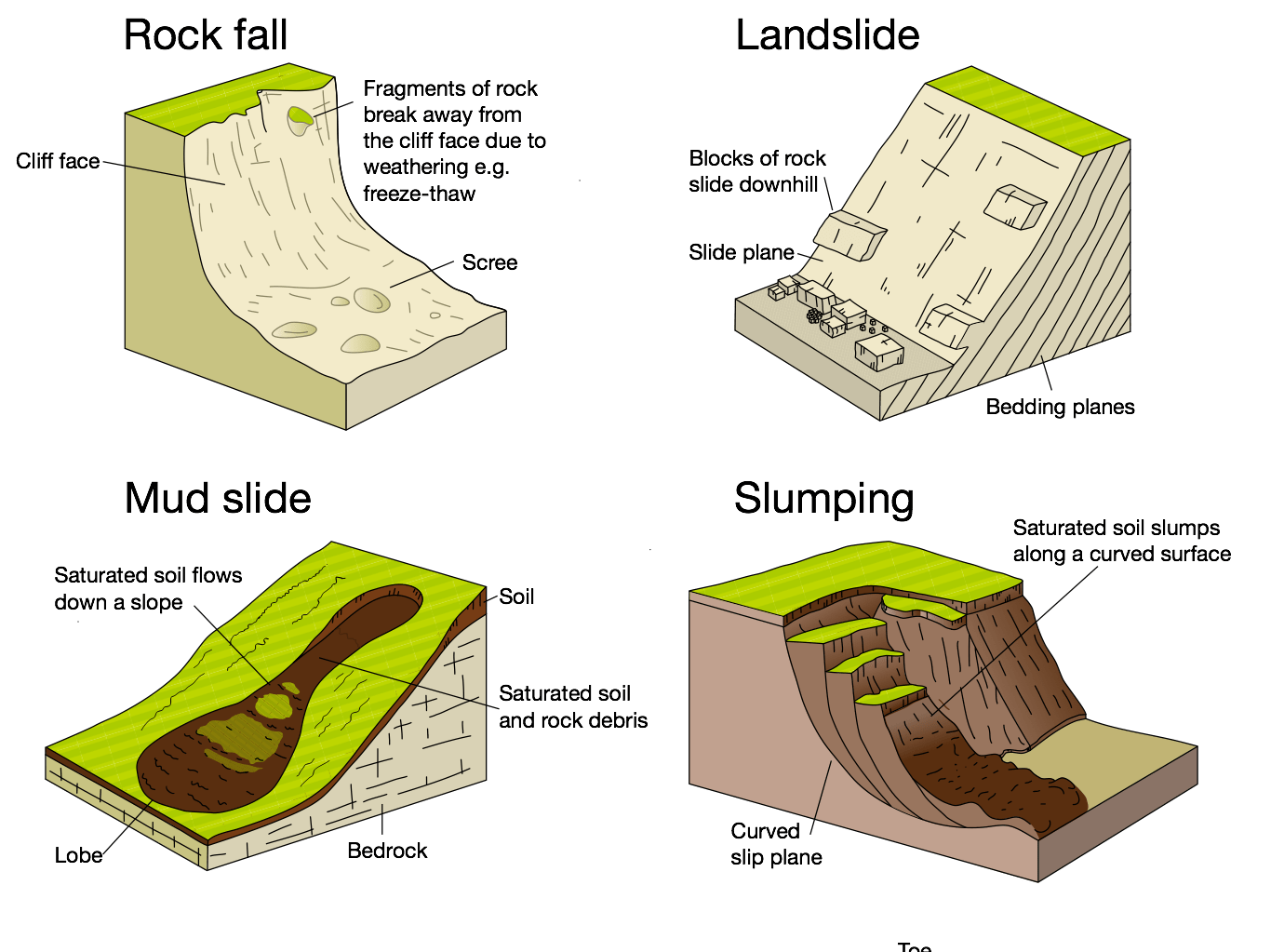
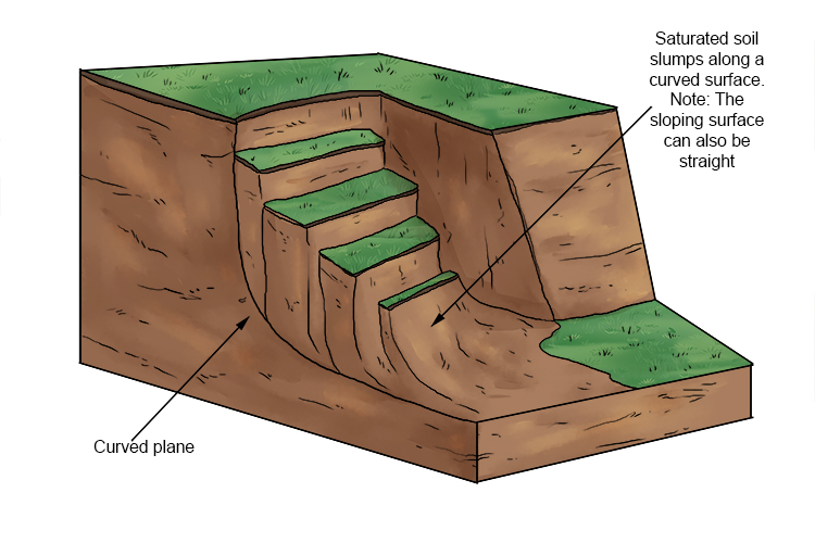
Slumping
Similar to slide + also occurs when stress acting on slope overcomes ability of slope to support own weight + resist movement
Often occur in saturated conditions
Rotational movement (not in sliding)
Occur on moderate to steep slopes
Common where softer materials (clay/sands) overlie more resistant/impermeable rock, e.g. limestone/granite
Causes rotational scars
Repeated slumping creates terraced cliff profile
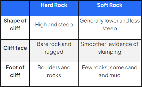
Influence of geology on coastal environments
Geology shapes coastline over time, place and space
Coastline made of softer rocks (sands/clays) is easily eroded by destructive waves to form low, flat landscapes such as bays and beaches
Coastlines of more resistant, harder rock take longer to erode + produce rugged landscapes such as headlands
Differences between hard/soft rocks impact shape + characteristics of cliffs
Geology shapes coastline vertically through height + profile of cliff and horizontally with bays + headlands
Influence of vegetation on coastal environments
The longer a coastal landform has existed, the more likely it will be colonised by vegetation
Over time, vegetation will ‘fix’ a feature (e.g. sand dune)
Vegetation adaptation important to survive coastal conditions
Vegetation has to cope with high levels of salt in air and soil
Largest influence of vegetation is to assist in protecting + preserving coastal landforms such as sand dunes, salt marshes, mangroves
Influence of people on coastal environments
Human activities transform features + landscape of coastline:
Settlement - coasts have always been place of attraction + residence for people
Economic development - exploitation through fishing, farming, trade, tourism, energy production
Coastal management - controlling coastline to protect human interests
Influence of sea-level changes on coastal environments
Rising sea levels produce submergent coastlines, with rias + fjords
Falling sea levels produce emergent coastlines, with relic features e.g. raised beaches, cliffs with caves
Sea levels have risen + fallen many times in past
During last Ice Age, sea levels fell as water locked up in glaciers + ice sheets, rising again as ice melted
Sea levels link to global warming, will have significant effect on many low-lying coasts + islands
Many Pacific islands, e.g. Kiribati, Tuvalu are at risk of being completely submerged by rising sea levels
Issue is worsened as many of world’s densely populated areas are on coastal lowlands
New York + Miami are major cities vulnerable to sea-level rise as cities are built at sea level
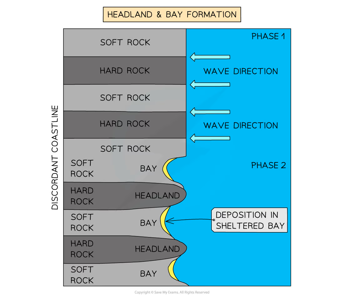
Headland and bay
Found in areas of alternating bands of resistant (hard) + less resistant (soft) rocks running perpendicular to oncoming waves (discordant coastline)
Initially, less resistant rock (e.g. clay) eroded back, forming a bay
Bay = inlet of sea where land curves inwards, usually with beach
More resistant rock (e.g. limestone) is left protruding out to sea as headland
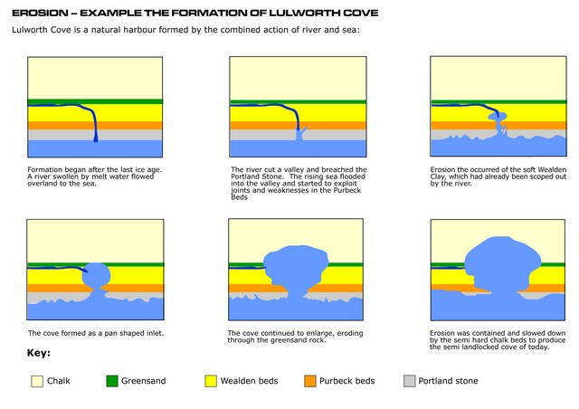
Cove
Forms when coastline has bands of resistant + less resistant rock running parallel to oncoming waves (concordant coastline)
Usually band of resistant rock facing waves, with band of softer rock behind
Wave processes exploit faults in resistant rock + erode through to softer rock
Further wave action erodes soft rock quickly, leaving circular cove with narrow entrance to sea
Wave refraction within cove spreads out erosion in all directions, creating typical horseshoe shape
e.g. Lulworth Cove, Dorset, UK
Cliff
Cliffs shaped through erosion + weathering processes
Less resistant rock erodes quickly, forming sloping cliff faces
Steep cliffs formed where harder rock faces sea
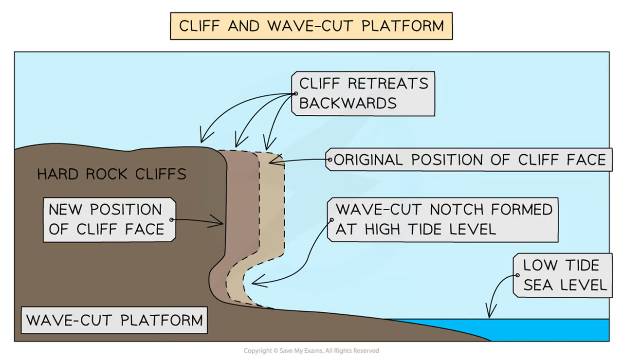
Wave-cut platform
Wide, gently-sloped surface found at foot of cliff
As sea attacks base of cliff between high and low water mark, wave-cut notch forms
Abrasion, corrosion, hydraulic action further extend notch back into cliff
Undercutting of cliff → instability + collapse of cliff
Backwash of waves carries away eroded material, leaving wave-cut platform
Process repeats + cliff continues to retreat, leading to coastal retreat

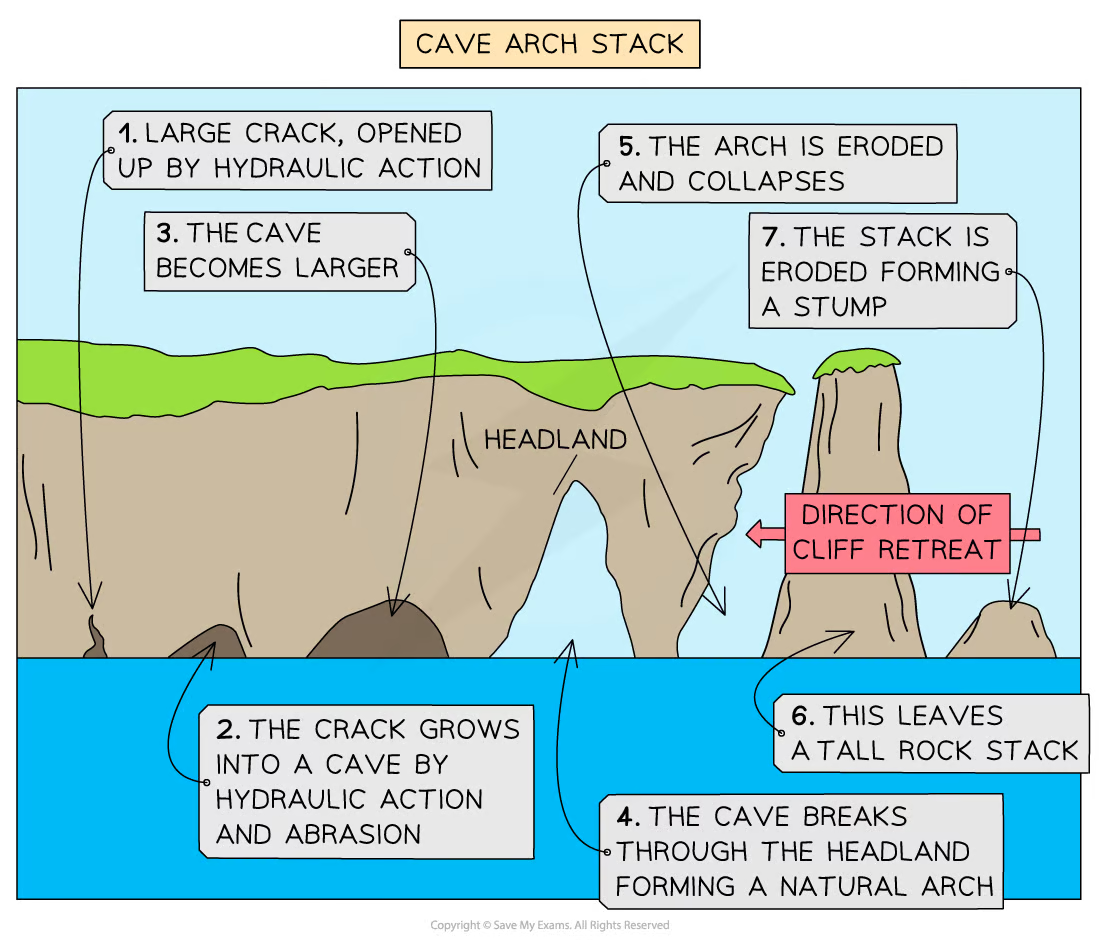
Cave, arch, stack and stump
Found on headland due to wave action + sub-aerial weathering
Weaknesses in headland are exploited by erosional processes of hydraulic action, abrasion, corrosion
As crack widens, abrasion wears away at the forming cave
Cave becomes larger and eventually breaks through headland to form arch
Base of arch continually becomes wider + thinner through erosion below + weathering above
Eventually, roof of arch collapses, leaving isolated column of rock called stack
Stack is undercut at base by wave action + sub-aerial weathering above until it collapses to form stump
Beach
Form in sheltered areas such as bays
Deposition occurs through constructive wave movement, where swash is stronger than backwash
Beach formation usually occurs in summer when weather is calmer
Sometimes sand from offshore bars can blow onto shore by strong winds
Blown sand can create sand dunes at backshore of beach
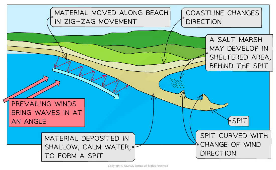
Spit
Extended stretch of sand/shingle that extends from sea to shore
Spits occur when there is change in shape of coastline
Or the mouth of a river, which prevents spit from forming across estuary
Spit may/may not have ‘hooked’ end, depending on opposing winds + currents
e.g. Spurn Point, Humber Estuary, England
Spit formation
Sediment transported by LSD
Where coastline changes direction, a shallow, sheltered area allows for deposition of sediment
Due to increased friction, more deposition occurs
Eventually, spit slowly builds up to sea level + extends in length
If wind changes direction, wave pattern alters, resulting in hooked end
Area behind spit becomes sheltered
Silts are deposited here to form salt marshes/mud flats
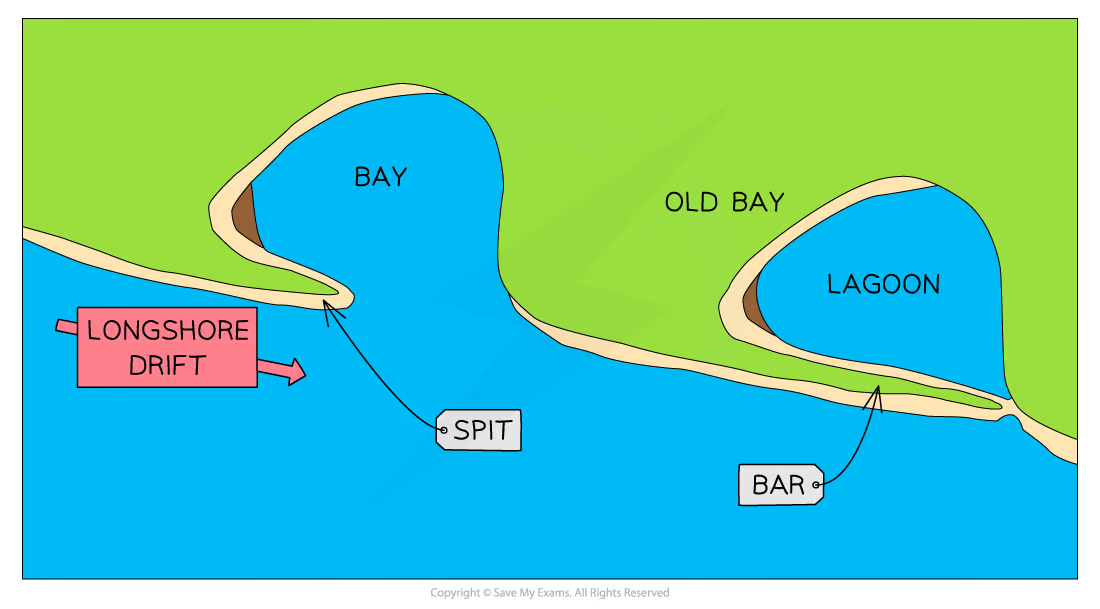
Bar
When spit grows across bay and joins two headlands together
Bar of sand is formed (sandbar)
Sandbars can form offshore due to action of breaking waves from beach
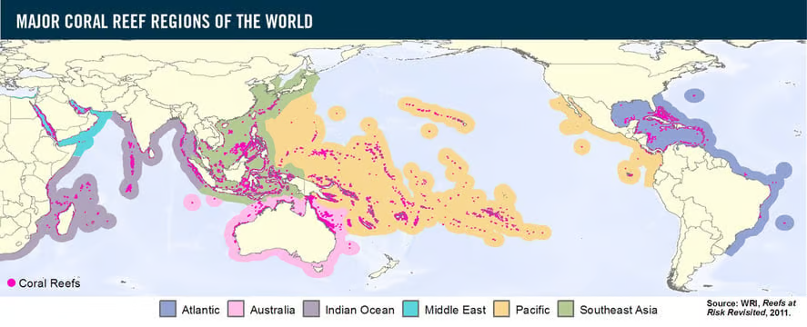
Coral reef distribution 🪸
Generally between 30ᵒ N and S of equator
Examples:
Great Barrier Reef (high biodiversity) - off coast of Queensland, AU
Maldives - Indian Ocean
Red Sea - Egypt
Coral reef global features 🪸
Temperature (min: 18ᵒC, optimum: 23-29ᵒC)
Shallow water (25m or less depth) because…
Closer to light
Coral can’t grow deeper than 25m because need light for zooxanthellae to photosynthesise
Clear water because…
Need light to pass through for PSN
Sediment blocks normal feeding patterns by reducing light availability
Salinity (between 32-42 PSU) because…
Coral are marine animals
so need salty water to survive
Coral reef local features 🪸
Wave action
Coral need well-oxygenated, clean water, which wave action provides
Exposure to air
Corals need oxygenated water but can’t be exposed to air for too long or will die
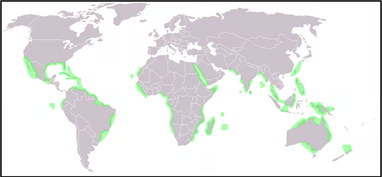
Mangrove distribution 🌳
Similar distribution to coral reefs
Mostly between 30ᵒ N and S of equator
Most common in SE Asia
Mangrove features 🌳
Mangroves are trees that live on coastline
Sit in water between 0.5-2.5m high
Range in size from small shrubs to trees 60m+ high
Have tangled roots that grow above ground and form dense thickets
Need high humidity (75-80%) and rainfall levels per annum (1500-3000mm)
Ideal temp = 27ᵒC
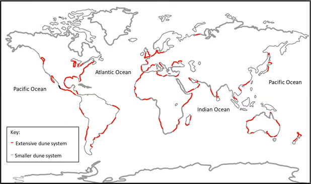
Sand dune distribution 🏖
Found all around the world
They are accumulation of sand, shaped into mounds and ridges by wind
Found at back of beach, above max reach of tide
Large dunes are less likely in tropical + sub-tropical areas because…
Lower avg. wind speeds
Damper sand
Sand dune features 🏖
Can be small ridge or large hills usually at back of beach
Can extend backwards for many miles as well as along beach
Are an important ecosystem, supporting unique flora + fauna that have adapted to live in dune system
Vulnerable to erosion by natural processes + human activity
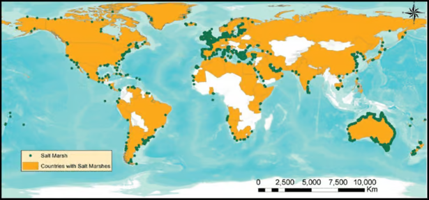
Salt marsh distribution 🧂
Found all over the world, not temperature dependent
An ecosystem of intertidal zone, like mangroves
Typically flat, with numerous channels running through them
They form in:
Well-sheltered coastal areas, such as inlets/estuaries
Areas behind spits and artificial seas defences
Brackish water (partly salty, partly fresh)
Salt marsh features 🧂
Communities of nonwoody, salt-tolerant plants
Begin as tidal mud flats, gaining height as more sediment is deposited
This builds up to and above the level, and frequency of tidal flooding ensures that soil never dries out, remains muddy + sticky
Pioneer species of halophyte plants begin to colonise
As plants die and add nutrients to soil, sediment builds up, making conditions more favourable and other species develop
Process of development of vegetation over time = succession
Lower marshes are flooded daily by rising tide
Good coastal defences in some areas, acting as natural buffer against coastal erosion + flooding
However, in many areas they’ve been reclaimed for agriculture/development, and are threatened by human activities
Abiotic characteristics of coral reefs 🪸
Light - need sunlight to survive:
Too little = zooxanthellae can’t photosynthesise to produce food for corals
Too much = corals may expel zooxanthellae, causing bleaching
Depth - need light, so are typically found at approx. 25m
Water temp - corals thrive in warm tropical waters
Salinity - need salty water
Air - can survive out of water for short periods
Water - need clean, clear water that doesn’t block light
Biotic characteristics of coral reefs 🪸
Coral reef is well-organised food web comprising of:
Producers
Consumers
Scavengers
Decomposers
Producers in coral reef include seaweed, seagrass and phytoplankton
Consumers are organisms that eat other organisms for energy
There are three main types of consumers in food web: primary (e.g. sea turtle eating seagrass), secondary (e.g. stingrays, octopuses), tertiary (help maintain balance of ecosystem, e.g. sharks, dolphins)Scavengers feed on dead + decaying plants and animals - e.g. crabs + lobsters
Decomposers bring nutrients back into ecosystem for another cycle - e.g. bacteria, fungi
Value of coral reefs 🪸
Biodiversity - Great Barrier Reef has 700 coral species, 1500 fish species and 4000 mollusc species
Protection to low-lying coasts from tropical storms
Rich fish stocks - supply basic food requirements of developing countries
Appeal to tourists + recreational opportunities, such as snorkelling + scuba diving - over 150m people each year take holidays in areas with coral reefs
How industry threatens coral reefs 🪸
Coral reefs are easily stressed by human action
If stress persists, death of reef soon followsPollution, overfishing and quarrying of coral for building stone
Industrialisation responsible for rising sea temp + sea-level rise, putting coral under threat
Rising sea temps increase levels of coral bleaching
How agriculture threatens coral reefs 🪸
Overfishing reduces number of grazing fish that keep coral clear of algae
Fishing using explosives that damage coral reefs
Commercial farming
Fertiliser runoff
Pesticide overspray
How tourism threatens coral reefs 🪸
Tourism is biggest threat globally and locally to coral reefs
58% of all coral reefs are at threat from human activity
Any contact with human body will likely kill coral immediately around point of contact
Propellers + anchors directly damage coral from boat tours
Pollution through diesel spills
How deforestation threatens coral reefs 🪸
Clearance of coral forests + mangroves disturbs natural flows of water + nutrients, leading to stress + coral bleaching
Removal of coral reef for stone building/tourist sales
Any destruction of coral reef leaves coastline open to coastal flooding + storm surges
Value of mangroves 🌳
Nurseries for fish + crustaceans; rich in wildlife
Roots, exposed at low tide, trap silt and help create new land
Timber provides fuel + building material
Protection from storm surges
How industry threatens mangroves 🌳
Pollution, overfishing and deforestation for aquaculture
Clearance for land development, particularly in developing countries
How agriculture threatens mangroves 🌳
Aquaculture - intense fish + shrimp farms
Pesticide use
Antibiotics used in aquaculture practices
Clearance for farm development, particularly in developing countries
How tourism threatens mangroves 🌳
Clearance of mangroves to build hotels + other tourist attractions
Diversion of fresh water to hotels etc.
Disturbance of habitats
Collection of souvenirs by tourists
Tours in waterways + pollution through spills of boat fuel
How deforestation threatens mangroves 🌳
Removal of trees leads to collapse of ecosystem
Leaves coast open to storms, flooding and coastal retreat
Mangrove wood used for timber + fuel
Cleared to reduce malaria - unsupported evidence that this works
Value of sand dunes 🏖
Coastal protection from flooding
Recreational activities e.g. trail biking + horse riding
How industry threatens sand dunes 🏖
Least threatened at global level (value is mainly tourism + leisure)
Local level, biggest threat is sand mining
How agriculture threatens sand dunes 🏖
Destabilisation due to animals grazing on dunes
How tourism threatens sand dunes 🏖
Largest threat to sand dunes due to trampling of delicate, unfixed dunes
Driving using 4×4/quadbikes over dunes
Sporting events - sand surfing etc.
Collecting shells + driftwood
Pollution from rubbish left by tourists
Car parks
Sand mining to build hotels
Development of seaside towns
How deforestation threatens sand dunes 🏖
Removal of trees destroys mature dunes and allows for dune migration
Leaves coast open to storms + flooding
Value of salt marshes🧂
Collectors of silt + organic matter
Nursery areas for fish + crustaceans
Protection against wave erosion + sea-level rise
How industry threatens salt marshes🧂
Industrial pollution
Ideal sites for nuclear power stations
Clearance for development - commercial + private
Development can lead to increased noise + light pollution, may affect wildlife behaviour + nesting
How agriculture threatens salt marshes🧂
Drained + cleared for farming
Eutrophication through heavy use of fertilisers
Pollution from pesticides + herbicides
Slurry run-off from cattle
How tourism threatens salt marshes🧂
Tourism limited to local level + nature reserves
Roads have divided salt marshes, cutting off parts of it
Trampling by visitors
Dog walkers letting dogs roam + disturb wildlife
Noise from local tourist areas may disturb wildlife
Uses of coastal environments
Development
Homes
Shops
Hotels
Roads
Schools
Restaurants etc.
Nature reserves
Industry
Fishing + aquaculture
Tourism
Agriculture
Ports + harbours
Conflict between Coastal users
Wildlife want unpolluted, safe and quiet environment
Local residents want jobs, clean beaches, affordable housing, schools
Tourists want beaches, hotels, B&Bs, entertainment, holiday homes
Employers want building space, offices, factories
Developers want areas by sea for tourists - hotels, duplexes, golf courses
Fishermen want harbours, unpolluted waters, ease of access to sea
Farmers want well-drained land, sheltered from prevailing winds
Govt. + councils want to build offshore wind farms, coastal defences
Transport companies want good road networks, well-connected ports and terminal
Issues with Agriculture in coastal zone
Consequences
Fertiliser and pesticide overuse
Increased livestock density
Overwater abstraction
Animal waste disposal
Land reclamation
Outcomes
Species and habitat loss
Eutrophication
Water pollution
Coastal squeeze
Issues with Urbanisation and Transport in coastal zone
Consequences
Change of land use (car parks, ports etc.)
Waste disposal
Pollution
Water abstraction
Hard road surfaces
Outcomes
Increased flooding
Congestion
Pollution
Loss of habitats
Increase in weeds + invasive species
Issues with Tourism and Recreation in coastal zone
Consequences
Harbours, marinas
Waste disposal
Fuel spillages
Change of land use
Water abstraction
Effluent disposal
Outcomes
Congestion + pollution (noise, light, visual, aroma)
Loss of habitats
Loss of species
Litter + fuel spills
Issues with Fisheries and Aquaculture in coastal zone
Consequences
Ports
Fish processing facilities
Trawlers
Road networks
Lorries
Fishing gear
Fish farm pollution
Water abstraction
Outcomes
Overfishing
Pollution on beaches
Habitat damage
Water pollution
Aroma, visual and noise pollution from trawlers
Increased seagull activity
Issues with Industry in coastal zone
Consequences
Land use change
Change in tidal range
Power stations (nuclear + gas)
Natural resource extraction
Road networks
Cooling water/abstraction
Waste pollution - chemical, biological, nuclear etc.
Outcomes
Thermal pollution
Habitat destruction, change and loss
Water eutrophication
Water pollution
Visual eyesore
Causes of coastal flooding
Storm surges - rapid rise in sea level caused by very low-pressure storms
Storm tides - occur when there’s combination of high tide + low-pressure storm
Tsunamis - large sea waves due to underwater EQs, closer to coast = bigger impact
Climate change - causes rising sea levels
Prediction of flooding
Early warning systems allow communities to prepare before flooding occurs
Past records (diaries, newspapers etc.) - identify areas at high risk of flooding and their frequency
Modern technology (GIS, satellite and computer monitoring, weather stations) - allow for forecasting + tracking potential hazards, i.e.
Tropical storms - track storm’s path + associated storm surge
EQs - size + position if underwater and possible tsunami outcome
These methods indicate possible strength + scale of flooding, and likelihood of damage + death
Prevention of flooding
Flood defences
Built along high-risk stretches of coast
Emergency centres
Centrally placed on higher ground where people can be safe from flooding
Early warning systems
Allows for preparation/evacuation of an area
Education
Informing locals on what to do if/when flood occurs
Building design
Planning new development away from high-risk areas
Designing buildings to cope with low-level flooding
Elevating buildings so flood water can pass underneath
Floodproof buildings with raised foundations
Reinforced barriers
Dry floodproofing - sealing property so floodwater can’t enter
Wet floodproofing - allows some flooding of building
Buffer zones
Areas of land are allowed to flood before reaching settlements
Allows energy in surge to dissipate, reducing the distance floodwater travels
Can mean moving people away from coast (could be controversial)
Shoreline Management Plans
Shoreline Management Plans (SMP) set out approach to managing coastline from flooding + erosional risk
Plans aim to reduce risk to people, settlements, agricultural land and natural environment
Hold the line (approach to coastal mgmt)
Long term approach + most costly
Build + maintain coastal defences so current position of shoreline remains same
Hard engineering is most dominant method used, with soft engineering used to support
Advance the line (approach to coastal mgmt)
Build new defences to extend existing shoreline
Involves land reclamation
Hard + soft engineering used
Managed realignment (approach to coastal mgmt)
Coastline allowed to move naturally
Processes monitored + directed when and where necessary
Most natural approach to coastal defence
Mostly soft engineering with some hard engineering to support
Do nothing (approach to coastal mgmt)
Cheapest method, but most controversial
Coast is allowed to erode + retreat landward
No investment made in protecting coastline or defending against flooding, regardless of previous intervention
Factors affecting which coastal mgmt approach to apply
Economic value of resources to protect e.g. land, homes etc
Engineering solutions - might not be possible to ‘hold the line’ for moving landforms such as spits
Cultural + ecological value of land - historic sites + areas of unusual diversity
Community pressure - local campaigns to protect region
Social value of communities - long-standing, historic communities
Hard engineering
Involves building some form of sea defence, usually from concrete, wood or rock
Structures and expensive to build and need to be maintained
Defences work against power of waves
Protecting one area can impact regions further along coast, resulting in faster erosion + flooding
Used when settlements + expensive installations (power stations etc) are at risk - economic benefit greater than cost of building
Groynes
Hard engineering method
Wood, rock or steel piling built at right angles to shore, trapping beach material being moved by LSD
Slows down beach erosion
Creates wider beaches
Stops material moving down coast where material may have been building up + protecting base of cliff elsewhere
Starves other beaches of sand
Wood groynes need maintenance to prevent wood rot
Makes walking along shoreline difficult
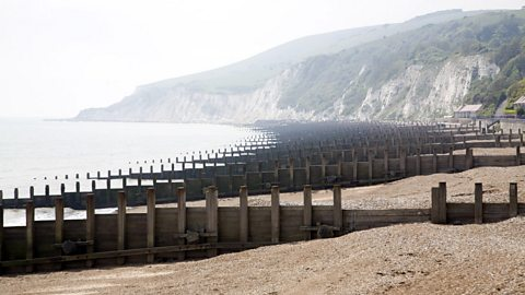
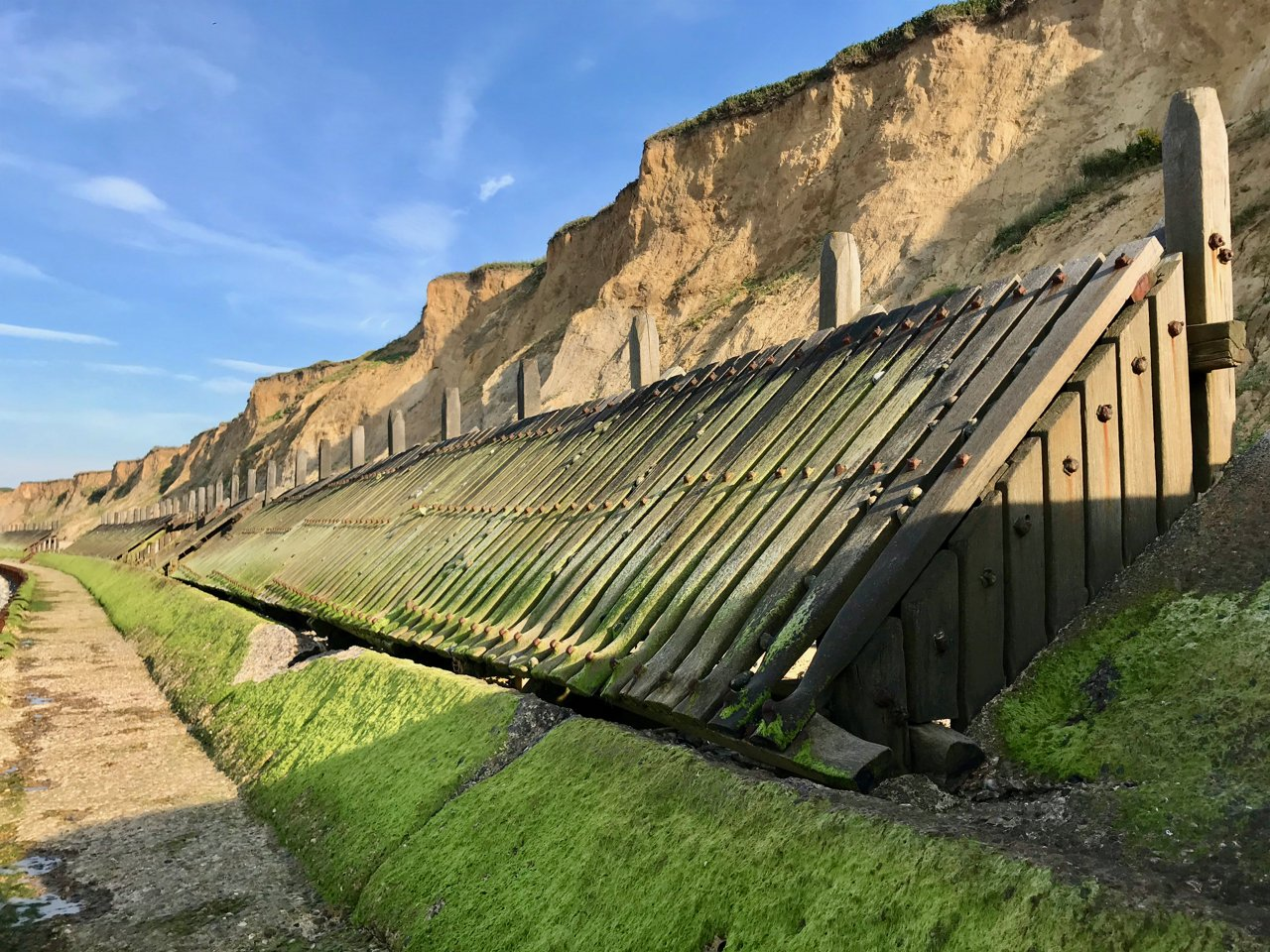
Revetments
Hard engineering method
Sloping wooden/concrete fence with open plank structure
Work to break force of waves
Traps beach material behind them
Set at base of cliffs/in front of sea wall
Cheaper than sea walls but not as effective
Ineffective in stormy conditions
Can make beach inaccessible for people
Regular maintenance is necessary
Visually unattractive
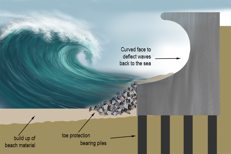
Sea wall
Hard engineering method
Wall, usually concrete, curved outwards to deflect power of waves
Most effective at preventing erosion + flooding (if wall is high enough)
Very expensive to build + maintain
Can be damaged if material isn’t maintained in front of wall
Restricts access to beach
Unsightly
Gabions
Hard engineering method
Wire cages filled with stone, concrete, sand etc
Cheapest coastal defence
Cages absorb wave energy
Can be stacked at base of sea wall/cliffs
Wire cages can break + need to be securely tied down
Not as efficient as other coastal defences
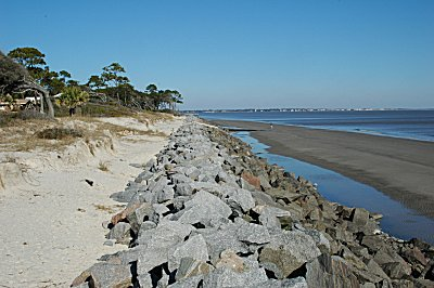
Rip-rap
Hard engineering method
Large boulders piled up to protect stretch of coast
Cheaper method
Works to absorb wave energy from base of cliff + sea walls
Boulders can be eroded/dislodged during heavy storms
Soft engineering
Works with natural processes rather than against them
Usually cheaper + don’t damage appearance of coast
Considered to be more sustainable appraoch to coastal protection
Not as effective as hard engineering
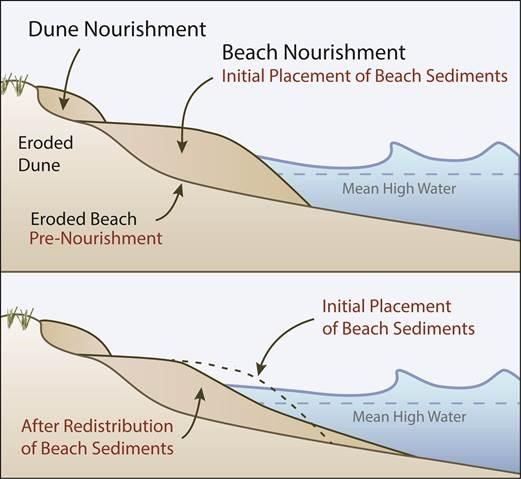
Beach replenishment
Soft engineering method
Pumping/dumping sand + shingle back onto beach to replace eroded material
Beaches absorb wave energy
Widens beachfront
Must be repeated regularly - expensive
Can impact sediment transportation down coast
Cliff regrading
Soft engineering method
Angle of cliff reduced to reduce mass movement
Prevents sudden loss of large sections of cliff
Regrading can slow down wave cut notching at base of cliffs as wave energy is slowed
Doesn’t stop cliff erosion
Fencing, hedging, revegetation
Soft engineering method
Helps stabilise sand dunes/beaches + reduces wind erosion
Cheap method against flooding + erosion
Hard to protect larger areas of coastline cliffs
Managed retreat
Soft engineering method
Existing coastal defences are abandoned, allowing sea to flood inland until it reaches higher land or a new line of defences
No expensive construction costs
Creates new habitats, such as salt marshes
Disruption to people where land + homes are lost
Cost of relocation can be expensive
Compensation to people + businesses may not be paid
Coastal problems in developed country (Abbotts Hall Farm, Essex, UK)
Essex coast in SE England is flat + low-lying
Abbotts Hall Farm = 282 hectare nature reserve and head office of Essex Wildlife Trust
Area was previously defended by 3km stretch of sea wall.
By 1990s, needed repairing, at considerable expense.
Coastal management in developed country (Abbotts Hall Farm, Essex, UK)
Decision was made to breach section of wall and allow 80 hectares of agricultural land behind wall to flood.
Aim was to allow nature to build up new coastal defence in form of new area of salt marsh.
Because relatively low-value land was targeted, and with sea level rise likely in future, this was sensible + cost-effective decision.
Essex Wildlife Trust very supportive, as salt marsh is valuable habitat for wading birds + important fish nursery.New walls created to protect farmland on either side of the site prior to section of old sea wall being breached in 2002.
Coastal problems in developing country (Guyana)
Country largely covered by tropical rainforest, though much of coastal lowlands have been clear to make way for plantations, especially sugar
Much of coastal zone is below sea level.
Coastline densely populated - 90% of country’s pop. live below sea level.
75% of Guyana’s economic activities, including almost all agriculture, are found below sea level.
Protection against coastal flooding is essential.
In past, Dutch settlers built network of coastal defences, with dykes + sea walls as barriers against sea and canals, pumps and sluices to drain low-lying areas.
More than half of old coastal defences are beyond repair, but coastline is threatened by sea level rise due to climate change.
As well as impacts of coastal flooding, salt water could ruin agricultural land + contaminate freshwater supplies.
Coastal management in developing country (Guyana)
Repairing existing hard defences, constructing new ones and paying cost of maintaining defences is too expensive for Guyana.
Restoring mangrove forests + wetland swaps to coastline and adding small earth dams is more cost-effective.
Restoring mangroves will have environmental benefit as they provide habitats for diverse range of wildlife.Education emphasising need to preserve mangroves, protect marine life (e.g. sea turtles) and refrain from dumping waste + litter should help make Guyana’s coastal management more sustainable.