Physical Geography of East Asia
1/44
Earn XP
Description and Tags
FOR GEOG 143 STUDENTS OF UP MANILA
Name | Mastery | Learn | Test | Matching | Spaced | Call with Kai |
|---|
No analytics yet
Send a link to your students to track their progress
45 Terms
Continental East Asia
China
Mongolia
Peninsular East Asia
North Korea
South Korea
Insular/Archipelagic East Asia
Japan
Taiwan
Eurasian and Indo-Australian Plates Collision’s effects
Creation of the Himalayas
Uplifting of Tibet into an upland elevated landform
Waters of melting snow in Tibet provide the essential waters of China’s great rivers
Rise of China’s western mountain ranges
Carving out of valleys in Eastern China
Pacific Ring of Fire
result of tectonic activity
a line of volcanoes at the Western Pacific Ocean
Mt. Fuji
Japan’s highest volcano cone; highest peak
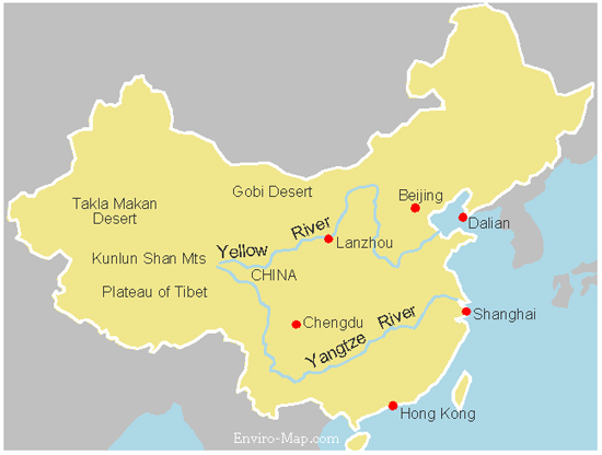
China’s Great Rivers
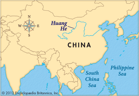
Huang He “Yellow River”
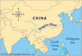
Yangtze (or Chang Jiang)

China’s other notable rivers
Xi Jiang (West River)
Zhujiang (Peark River)
Yalu Jiang (Amnok River)
River bordering North Korea and China
Yalu Jiang (Amnok River)
Other name for Huang He
The cradle of Chinese civilization
Other name for Yangtze
“Blue River” → causes sadness every year due to its massive floods

Northern China
location of Huang He

Mid-Central China
location of the Yangtze
China’s Western Mountains
Kunlun Shan
Altun Shan
Tien Shan
China’s notable or major valleys/plains
North-Eastern Plain or the “Manchurian Plain”
North China Plain
What rivers irrigate the North China Plain?
Huang He “Yellow River” and Liao River
China’s (North-) Eastern Plains/Manchurian Plain are watered by what rivers?
Songhua River and Liao River

Songhua River
the river that waters the Manchurian Plain
North-Eastern China Plain’s crops:
barley
corn
flax
millet
soybeans
wheat
North China Plain’s crops:
cotton
maize
millet
peanuts
sesame seeds
sorghum
wheat
Factors for East Asia’s Climate
Mountain Ranges
Bodies of Water
East Asia’s Mountain Ranges
Atlai Mountains (prominently in Mongolia)
Himalayas (especially on the Tibet side)
Japanese Alps: Hida, Kiso, Akaishi Mountains
Kunlun Mountains (west of China)
Qinglling Shandi Mountains (southeastern and east-central China)
Three Sacred Mountains of Japan
Mount Fuji
Mount Tateyama
Mount Haku

East Asia’s major deserts
Gobi Desert
Takla Makan Desert
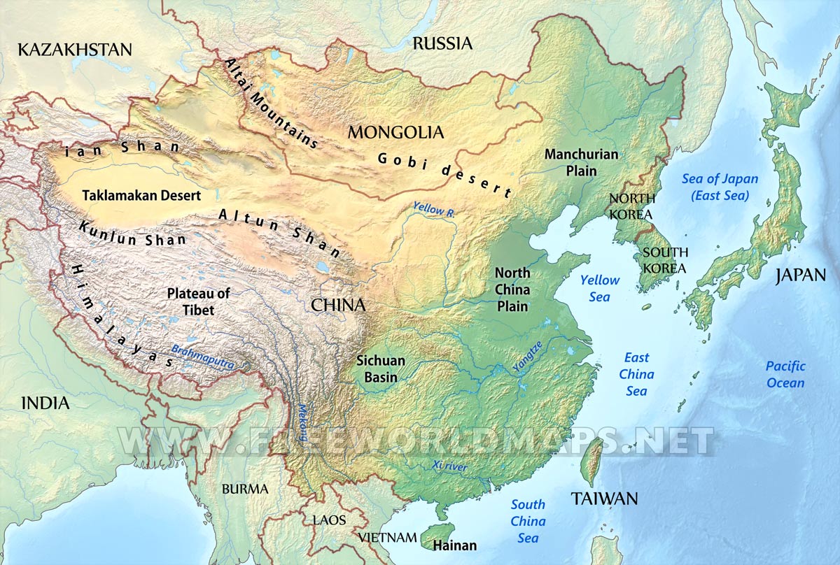
East Asia’s major bodies of water
East China Sea
Sea of Japan
South China Sea
Yellow Sea
East Asian countries with humid continental climate?
Japan
North Korea
Yak
The animal most suited to Tibet’s highland climate due to:
having more red blood cells → more efficient oxygen circulation
larger lungs and heart than most cattle
Horse
The animal most suited in traversing steppe landscape such as in Mongolia
Uses for Goat in Mongolia
Cashmere — Mongolia’s number 1 export
meat and milk
Hanami
Japan’s celebration of cherry blossoms
Cherry Blossom heralds what?
The start of spring in Japan
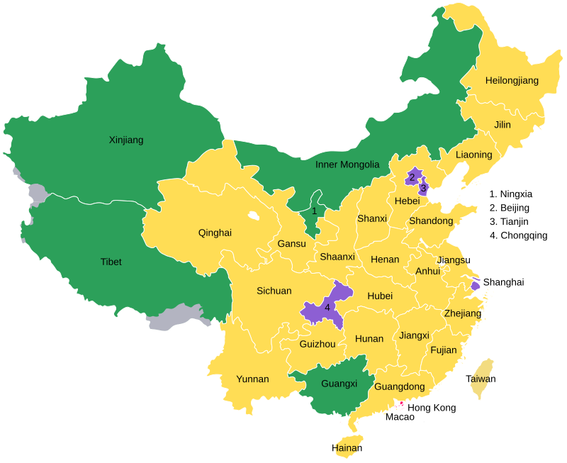
China Proper
the nucleus of China:
residence of majority of the population (Han Chinese)
houses the central administrative region
“Historic China”

China’s Autonomous Regions
Guangxi Zhuang
Inner Mongolia
Ningxia Hui (*not included in ppt)
Xinjiang Uyghur
Xizang (Tibet)
Hainan
China’s major island; located on SCS
The Korean Peninsula’s major island
Jeju Island; southern part of the peninsula
Japan’s 4 Main Islands
Hokkaido
Honshu
Shikoku
Kyushu
Japan’s Plains
Kanto Plain
Nobu Plain
Osaka Plain
Ishikari Plain
Japan’s 2 main topographic problem
lack of arable land
vulnerable to earthquakes and tsunami
Japan’s warm water fishes
sardine
herring
tuna
mackerel
Japan’s cold water fishes
cod
halibut
salmon
Japan’s cultivated seafoods
Prawns
Oysters
Seaweeds
Shrimp
Chungyang Mountain Range
Taiwan’s principle mountain group
What East Asian countries have deciduous forests (trees that shed leaves in autumn and grow new ones in the spring)?
China
Japan
Korean Peninsula
Taiwan
China’s 2 Special Administrative Regions (located on the SCS)
Hong Kong
Macau
East China’s man-made features
The Great Wall of China
Three Gorges Dam
Korean Demilitarized Zone (KDMZ)