Oceanography Midterm #1 (Plate Tectonics)
1/27
There's no tags or description
Looks like no tags are added yet.
Name | Mastery | Learn | Test | Matching | Spaced | Call with Kai |
|---|
No analytics yet
Send a link to your students to track their progress
28 Terms
Plate Tectonics
Plate tectonics affects all of us, whether in relation to the
destruction caused by volcanic eruptions and
earthquakes, or politically and economically, due to the
formation and distribution of valuable natural resources.Plate tectonics is the unifying theory of geology, tying
together many seemingly unrelated geologic
phenomena and illustrating why Earth is a dynamic
planet of interacting subsystems and cycles.Explains why we have mountains and volcanoes in certain places and why Earthquakes happen
Protoearth
Larger than Earth today
Homogeneous composition
Bombarded by meteorites
The Moon formed from a collision with a large asteroid
Radioactive heat
Spontaneous disintegration of atoms
Fusion reactions
Heat from contraction (protoplanet shrinks due to gravity)
Protoearth partially melts
Density Stratification (layered Earth)
Earth’s Interior (Chemical and Physical Comp)
Chemical Composition
Crust
Mantle
Core
Physical Composition
Lithosphere
Asthenosphere
Mesosphere
Outer core
Inner Core
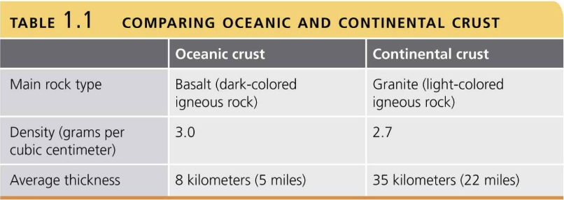
Crust
The outermost layer, the crust, is low-density, mainly composed of silicate minerals.
continental crust: granite, thicker
oceanic crust: made of basalt, thinner crust, higher density
Mantle
The mantle surrounds the core and is divided into:
Lithosphere: Ridged(solid), brittle plates that move at the surface
an asthenosphere that behaves plastically and flows slowly.
Mainly iron (Fe) and magnesium (Mg) silicate minerals.
Mesosphere (ridged)
more magnesium
very rare to have this type of rock reach the surface
Silicate materials
Core
The core consists of:
A small, solid inner region
A larger, liquid, outer portion
Flow generates Earth’s magnetic field
❑ High-density, mainly iron (Fe) and nickel (Ni)
Alfred Wegener (1912)
First Proposed Continental Drift
The Theory of Plate Tectonics is a fundamental foundation for the geosciences - explains the surface features on the Earth
Pangaea consisted of a northern landmass called Laurasia and a southern landmass called Gondwana.
As Pangaea broke up, the various continents moved to their present-day locations.
Concluded that the crusts move
Came up with Pangea
First to come up with the idea that the lithosphere is moving and that all continents were together (Pangaea)
Evidence of Continental Drift
Fit of continents (the outline of the continents)
Matching geological units ( look at rock types and mountain chains)
Look at the layers, dates, and ages of rocks
Continents once fitted together – Pangaea, one large continent, existed 200 million years ago
Panthalassa – one large ocean
Noted puzzle-like fit of modern continents corroborated in the 1960s
Sir Edward Bullard used computer models to fit continents.
There is a close fit between the continents off the coast at a
depth of about 2000 m.
Glacial ages ( find certain details on rocks that can determine directions of ice)
Find that polar regions are colder during periods when the Earth is tilted a certain way-
Glacial cycles
Suggests that Antarctica was connected to South America, India, and Australia
When ice moves, it’s like a bulldozer
Pulverizes rock through abrasion, it will streak the hard rock, revealing the direction of the ice
Those plates at one point moved
Distribution of fossils ( looking at specific fossils that can only be in certain locations, only found in certain regions, but are now split apart)
Glossopteris fern
Mesosaurus, freshwater reptile
Objections to Continental Drift
Hostile criticism and open ridicule (The Origins of Continents and Oceans, 1915)
Continents cannot plow through ocean basins
Tidal gravitational attractions are too small
The hypothesis was correct in principle; however, The proposed mechanism defies the laws of physics
Erosion is happening, so they don't fit perfectly now
Paleomagnetism
Researchers refined new techniques (radiometric dating), developed new instruments (sonar), and discovered new fossils, which strengthened Wegener’s argument;
However, it was the research obtained from paleomagnetism and the exploration of the sea floor, which provided evidence of plate movements and the ocean floor spreading
Liquid core and it rotates, making Earth a magnet
Measure the movement and intensity of magnetic fields
Paleomagnetism is the remnant magnetism in ancient rocks recording the direction and intensity of Earth’s magnetic field at the time of the rock’s formation.
Magnetic polarity recorded in igneous rocks
Magnetite in basalt, a natural magnetic mineral, when lava cools, it locks in place, which allows us to measure its intensity
Geographic North- Stays the Same
Magnetic North - Keeps Moving
Earth’s Magnetic Field
Earth’s present magnetic field is considered normal
Normal – with the north and south magnetic poles located approximately at the north and south geographic poles.
At various times in the geologic past, Earth’s magnetic field has completely reversed
One day, we are going to have a compass; over time, the earth is going to switch, and north will become the opposite
Will impact navigation immensely
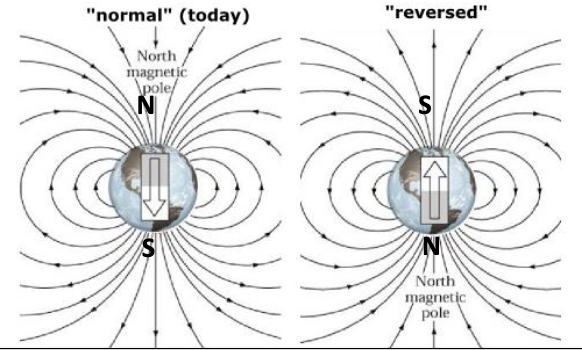
Magnetic Reversal
Earth’s magnetic polarity reverses periodically
Recorded in ancient igneous rocks
176 reversals in the past 76 million years
Unpredictable pattern
Last occurrence – 780,000 yrs
Sir Edward Bullard: Looked beyond the shoreline at the continental shelves, they started to fit identically
Everyone in the Arctic is now looking at the continental shelves
A mountain chain that spits
Sea Floor Mapping
1955 – deep water rock mapping
Magnetic anomalies – regular pattern of north-south magnetism “stripes”
Stripes were symmetrical about the long underwater mountain range
Sea Floor Spreading
Harry Hess - World War II submarine captain and geologist
Depth recordings show sea floor features
History of Ocean Basins
Proposed - Seafloor spreading
Mantle convection cells as a driving mechanism
The mid-ocean ridge is a continuous underwater mountain range.
Wraps 1.5 times around the globe.
Rises 2.5 km
Frederick Vine and Drummond Matthews (1963)
Seafloor spreading was confirmed by the discovery of magnetic anomalies in the ocean crust that were both parallel to and symmetric around the ocean ridges.
This indicates that new oceanic crust must be formed along the spreading ridges.
The oldest ocean floor is only 180 million years old
Normal reverse was the result of these plates
Deep-sea drilling and the confirmation of seafloor, younger rock first, then the more you go, the older the rock gets
The Pacific is getting smaller, atlantic is getting bigger
Further evidence confirming seafloor spreading came from the Deep Sea Drilling Project are the age and thickness of the sediments overlying the oceanic crust.
Millions of earthquakes occur every year
We can measure this quickly and effectively
Friction between plates can locate earthquakes based onthe outlines of rocks
Plate tectonic Acceptance
Overwhelming evidence in support of plate tectonics led to its rapid acceptance and elaboration since the early 1970s.
The theory is widely accepted because it explains so many geologic phenomena, including volcanism, seismicity, mountain building, climatic changes, animal and plant distributions in the past and present, and the distributions of natural resources.
For these reasons, it is known as a unifying theory.
Moves from warm convection cells within the mantle that drive them apart
Much evidence supports the theory today
Supporting Evidence: Earthquakes
Most large earthquakes occur at subduction zones.
Earthquake activity mirrors tectonic plate boundaries.
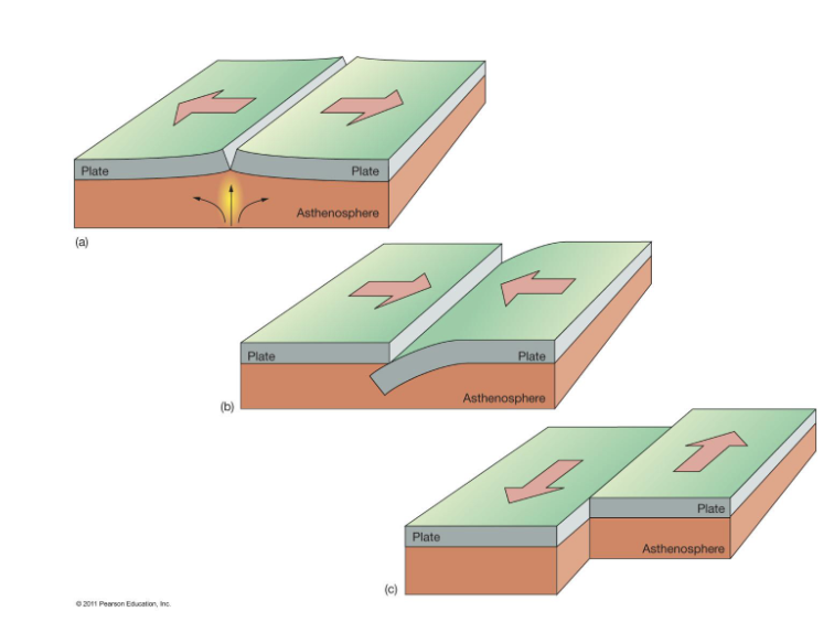
Plate Boundaries
Divergent
Mid-ocean ridge, plates move away from each other, the most common
Convergent
run into each other, plate approach each other, granite and basalt if they collide with each other
Transform
Plates slide past each other
Divergent Plate Boundaries
An Example of Ancient Rifting
Characteristic features of ancient continental rifting include faulting, dikes,
sills, lava flows, and thick sedimentary sequences within rift valleys. Pillow lavas and associated deep-sea sediments are evidence of ancient
spreading ridges.
Convergent Plate Boundaries
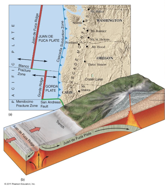
Oceanic-continental Convergence:
The ocean plate will be subducted due to the salt material being denser: Pushed into the Earth
Gets pulled back into the earth and is recycled
Creates a very deep trench
Basalt and Granite
Most interesting Landforms, making very deep trenches
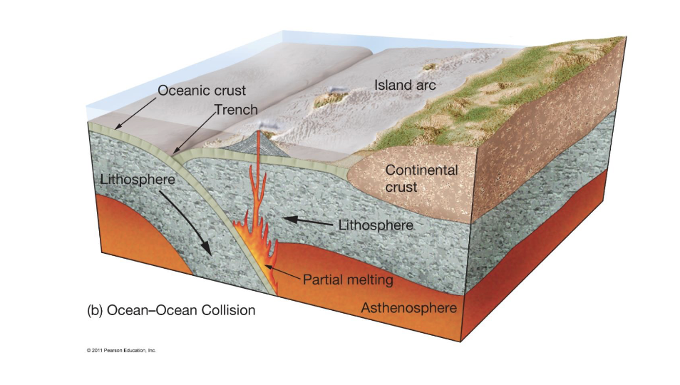
Oceanic-oceanic Convergence:
Both salted and unsalted material
The denser plate is subducted and is older
Even though it's the same material, the more dense, the more likely it will be subducted
Trenches will be found
Island arcs, made from material from plates (salt)
older
Continental-continental Convergence:
Granite and granite, light in density
No subduction!
Too light and not dense enough
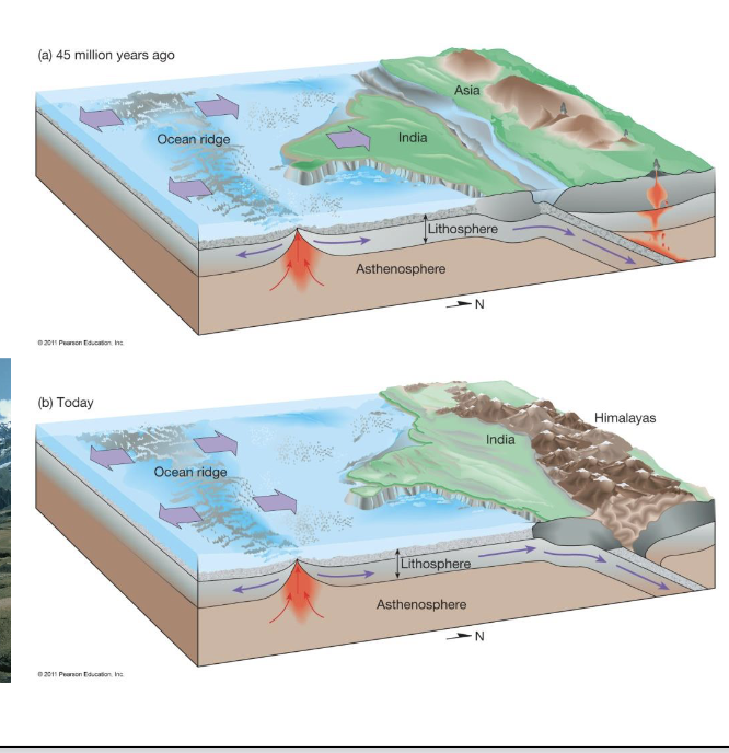
If granite and granite smash into each other, you will have high mountain chains, tall/uplifted mountains: Himalayan (still growing)
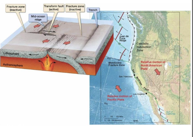
Transform Plate Boundaries
These are boundaries along which plates slide laterally past each other along transform faults.
Oceanic Transform Fault- ocean floor only
Continental Transform Fault- Cuts across the continent
San Andreas Fault
Transform faults occur between, mid-ocean ridge segments
Nematath - Hotspot Track
Recorded Ancient Plate Motions
Adding water to magma makes it go crazy, and adding weight leads to molten
Not close to a plate boundary, it spews out
Mantle plume doesn't move, while the plates still move
Magma turns to lava and builds up, dividing the plates, creating island chains
New islands come up as the present ones shift over, creating the chain
All islands will disappear, but new ones will be made
We can measure this with technology today; continents move at the rate of your fingernails
The Pacific is getting smaller, the Atlantic is getting bigger
Past and Future Plate Movements
Satellites have detected and measured plate movements over time
Paleogeography
The study of historical changes of continental shapes and positions
Continental Accretion
Continental material added to edges of continents through plate motion
50 Million Years in the Future
Assume the same direction and rate of plate motions as now
◼ Atlantic will enlarge, Pacific will shrink
◼ New sea from the East African rift valleys
◼ Further Himalayan uplift
◼ Separation of North and South America
◼ Part of California in Alaska
Mineral Deposits
Many metallic mineral deposits are related to igneous and associated hydrothermal activity, so it is not surprising that a close relationship exists between plate boundaries and the occurrence of these valuable deposits
Many of the world’s major metallic ore deposits are associated with convergent and divergent plate boundaries. Copper, iron, lead, zinc, gold and silver ore
Deposits are associated with plate boundaries.
Distribution of Life
Fossil evidence provided one of the first proofs for plate tectonics. Together, plate tectonics and evolution have changed the way we view our planet.
the world’s plants and animals occupy biotic provinces controlled mostly by:
• Climate
• Geographic barriers
• The location of these provinces is mostly controlled by plate movement.
The world's plants and animals occupy biotic provinces controlled mostly by:
Climate change
Geographic barriers
Genova's features, passive margins