Army JROTC Land Navigation
1/32
Earn XP
Description and Tags
Name | Mastery | Learn | Test | Matching | Spaced |
|---|
No study sessions yet.
33 Terms
Large map scale
1:50,000
Medium map scale
1:100,000
Small map scale
1:250,000
Definition of a map
A geographic representation of a portion of the Earth’s surface drawn to scale, as seen from above.
Purpose of a map
To provide information on the existence of, location of, and distance between ground features.
Black on a map
man-made features, such as buildings and roads
Red-brown on a map
relief features and elevation (contour lines on red-light readable maps)
Brown on a map
relief features and elevation (contour lines on older maps)
Green
vegetation (woods, orchards, vegitation)
Blue on a map
drainage (water)
Red on a map
populated areas, main roads and boundaries on older maps
The five major terrain features
hilltop, valley, ridge, saddle, depression
Mnemonic phrase for the five major terrain features
Hidden Valley Ranch Salad Dressing
The three minor terrain features
draw, spur, cliff
The two supplementary terrain features
cut, fill
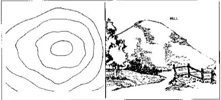
Definition of a hilltop
An area of high ground. From a hilltop, the ground slopes down in all directions.
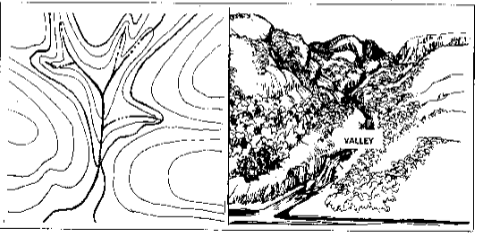
Definition of a valley
A stretched-out groove in the land, usually formed by streams or rivers.
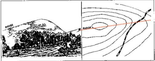
Definition of a ridge
A sloping line of high ground.
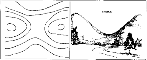
Definition of saddle
A dip or low point between two areas of higher ground.
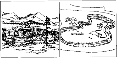
Definition of a depression
A low point in the ground or sinkhole. They are represented by close contour lines that have tick marks pointing toward low ground.
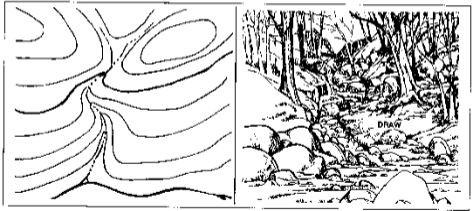
Definition of a draw
A less developed steam course than a valley. There is essentially no level ground and, therefore, little or no maneuver room within its confines.
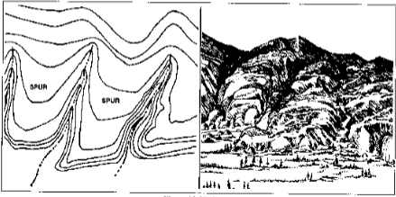
Definition of a spur
A short, continuous sloping line of higher ground, normally jutting out from the side of a ridge.
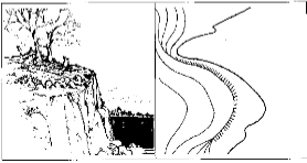
Definition of a cliff
A vertical or near vertical feature; it is an abrupt change of the land. The slope is so steep that the contour lines converge into one contour line or the last contour line has tick marks pointing to low ground.
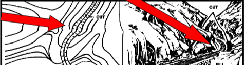
Definition of a cut
A man made feature resulting from cutting through raised ground, usually from a level bed for a road or railroad track.
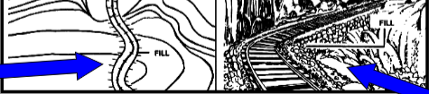
Definition of a fill
A man-made feature resulting from filling a low area, usually to for a level bed for a road or railroad track.
What are the three types of contour lines?
Intermediate, supplementary, index
Definition of an intermediate contour line
Contour lines located between two index lines.
Definition of a supplementary contour line
Contour lines placed to specify half or the contour interval.
Definition of an index contour line
Major elevation points that have the elevation number written within the contour (ex.100m,200m,300m).
How do you read a map?
right and up
What is a four digit coordinate?
A location within 1000m
What is a six digit coordinate?
A location within 100m
What is an eight digit coordinate?
A location within 10m