CS - Asian Tsunami 2004 - Hazardous Earth
1/29
There's no tags or description
Looks like no tags are added yet.
Name | Mastery | Learn | Test | Matching | Spaced | Call with Kai |
|---|
No analytics yet
Send a link to your students to track their progress
30 Terms
When?
26th December 2004 at 7:56am
Where?
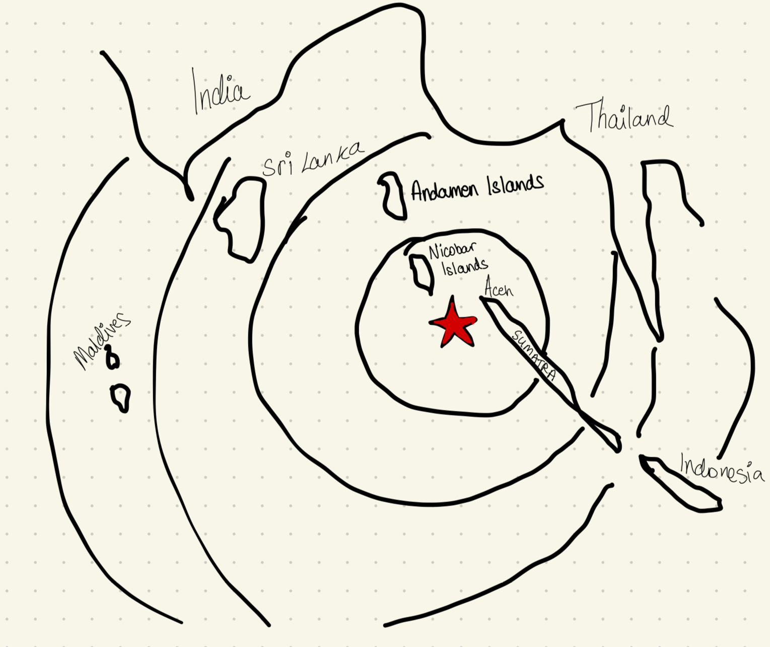
North-west coast of Sumatra
What caused it?
Subduction of the Indo-Australian plate under the Eurasian plate along a fault 1200km long.
10-20m of vertical motion
What was it?
A 4 minute earthquake
Magnitude 9.0 on Richter scale
Epicentre only 150km from land
Focus only 30km deep
What factors contributed to the high vulnerability and impacts in the area?
Tsunamis uncommon in Indian ocean, so coastal communities in countries such as Indonesia and Sri Lanka were unaware of the dangers posed by tsunamis, so unprepared
Most of the island chains in the Indian ocean, e.g. the Maldives, are flat and low-lying. Many of the coastlines also tend to be flat/very gentle slope.
Fishing villages + tourist towns built right up to the water’s edge to make max use of the magnificient beaches.
So, the tsunami rolled well inland with little to no resistance, and picking up debris and heavy objects along the way
Much of Indian ocean densely populated. Thriving fishing communities and tourism has flourished = large numbers of people at risk
Many of countries affected, e.g. Indonesia and Sri Lanka, are extremely poor. Did not have the necessary emergency supplies, procedures, and infrastructure to cope with this disaster so needed heavy foreign assistance
No early warning system for the Indian ocean. Only Thailand had a warning system, which failed. This is bc of the infrequency of tsunamis in the area. 10,000s people could have been saved.
The Pacific Tsunami Warning Center in Hawaii picked up on the earthquake but did not have the necessary contacts to alert officials in Thailand
There was a 2 hour delay between the wave hitting Sumatra then Thailand
Time: the focus was shallow, and the epicentre close to the coastline.
There were only 15 minutes between the earthquake and the tsunami hitting Aceh
Draw a map of the location of the earthquake
What happened in Sumatra (Indonesia)
Northern province of Aceh was closest to the epicentre and was worst affected.
Waves up to 12m travelled 2km onshore
At least 100,000 killed
80% of the province was destroyed
What happened in Sri Lanka?
~28,000 killed
Mostly dead on Eastern seaboard
What happened in India?
Worst hit area was the remote coastline in the Southern province of Tamil Nadu
Hit by 10m high waves
15,000 people killed
What happened in Thailand
Southern Thailand holiday beaches devastated
Majority of the 7,000 deaths were among foreign tourists
Andaman and Nicobar Islands
Unknown numbers of people - possibly more than 30,000 killed
Survivors left without food and battling crocodiles washed onshore by the tsunamis
What happened in the Maldives
Only 67 deaths confirmed, and 68 of the 87 tourist resorts remained open
Sri Lanka absorbed most of the energy
The Maldives’ atolls are on top of 3000m tall, practically vertical underwater mountains, so all that was felt at the surface was a ripple compared to what could have been.