211 Quiz 2
1/73
There's no tags or description
Looks like no tags are added yet.
Name | Mastery | Learn | Test | Matching | Spaced | Call with Kai |
|---|
No analytics yet
Send a link to your students to track their progress
74 Terms
4-stage model stage 1
Stand Initiation
Key processes:
o Stand initiating disturbance followed by colonization by early-successional / pioneer
species.
• Key structural attributes:
o Accumulation of biomass, beginning of vertical stratification (plants grow at different rates)
o May appear “brushy (overgrowing of small plants)
4-stage model stage 2
Stage name:
o Stem Exclusion
• Key processes:
o Density-dependent mortality (i.e., higher probability of mortality in areas that are more
“crowded”).
o Resource limitation leading to intense competition
• Key structural attributes:
o Very dense canopy, but trees have small crowns.
o Single-cohort canopy. (All trees originating at roughly the same time)
4-stage model stage 3
Stage name:
o Understory Re-Initiation
• Key processes:
o Differentiation of canopy structure.
o Density-independent mortality. (. Deaths related to small-scale disturbance, like insects or pathogens.)
o Small canopy gaps resulting in more light reaching forest floor.
o More herbs, shrubs, and seedlings.
o New cohort of shade-tolerant tree species establishes
• Key structural attributes:
o Trees in canopy have large crowns
Emergence of a new cohort of trees in the understory.
4-stage model stage 4
Stage name:
o Old-growth
• Key processes:
o Gaps form in canopy due to mortality of individual trees or small groups of trees. Deaths
due to senescence (old-age death, especially of early-successional or pioneer cohort),
small-scale disturbances (e.g., wind), and pathogens
o These gaps allow tree regeneration, or recruitment (into the canopy) of previously
suppressed trees in the understory.
• Key structural attributes:
o Multiple cohorts
o Large, dead standing trees (snags) and significant coarse woody debris.
o Some large live trees, but also diversity in tree sizes.
o High vertical and horizontal structural diversity. E.g., multiple layers in the canopy and
variation as you move through the forest.
What are some potential shortcomings of this 4-stage model? (For example: What is this model
missing or failing to account for? In what ways might this model be unrealistic?)
This model assumes disturbance is severe and primarily plays a role in stand imitation.
o Assumes stand-initiating disturbances create a “blank slate” for the new ecosystem,
with no remaining legacies of the pre-disturbance ecosystem.
o Focused very heavily on the early stages of stand development, even though this may be
a short part of the stand history in areas (like coastal BC) with very long-lived tree
species.
Name the stages in the 8-stage model of stand development?
1. Disturbance and legacy creation
2. Cohort establishment
3. Canopy closer
4. Biomass accumulation + competitive exclusion
5. Maturation
6. Vertical diversification
7. Horizontal diversification
8. Pioneer cohort loss.
What are some of the key differences between the 4-stage and 8-stage models of stand development?
The 8-stage model accounts for legacies left behind after the disturbance rather than assuming that the forest is starting from nothing like the 4-stage model does.
• More descriptive.
• 4-stage focuses on early development while 8-stage focuses on the whole lifespan.
general definition of old growth
forest with very old trees where ecological processes can occur w/o human intervention (self sustaining)
has big widely spaced trees
canopy dominated by long-lived shade-tolerant species
has a diverse range of tree ages (constant tree regeneration)
wide range of tree sizes
structure of old growth
vertical diversity (multilayered canopy)
horizontal diversity (birds eye view, dif density and gaps)
snags (non-living) standing dead trees (habitats)
snags fall = course woody debris
small scale disturbances of old growth
old growth structure is dominated by small scale disturbances
wind
small disease/pests
senescence, death of old age
this leads to gap dynamics (more light availible) which are filled by shade tolerant species
What makes Douglas-fir a somewhat unusual member of old-growth coastal temperate rainforests?
douglas fir is a shade intolerant species but has a very long lifespan (500-1000) so it may live well into the old-growth stage.
The established trees will continue to survive, but will not regenerate
8 stage model - stage 1
Disturbance and biological legacies
some mature trees likely survive first major disturbance (legacies)
legacies survive and begin repopulating
8 stage model - stage 2
Cohort establishment
new cohort of trees estabish (hemlock and douglas fir are pioneer species in BC)
strongly effected by legacies of previous stand (source of seeds)
8 stage model - stage 3
Canopy closure
trees fill up spaces, full forest, no new trees can establish
high density, high relative humidity (beneficial), protected from wind
8 stage model - stage 4
Biomass accumulation and competitive exclusion
trees grow rapidly competing for resources, density dependant mortality
may be some self thinning (entire plant dies) and pruning (shed lower branches)
8 stage model - stage 5
Maturation
max height and canopy size
canopy develops layers
shade tolerant plants establish
8 stage model - stage 6
Vertical diversification
start of old growth
complex, multilayer canopy
density independent and dependant mortality
8 stage model - stage 7
Horizontal diversification
gap formation, large = more light, more regeneration
Pioneer Cohort Loss
shade intolerant pioneer species absent from understory
stand
spacially continuous group of trees
unit of forest
stand structure
physical distribution of trees and plants in stand
stand development
stand over time
cohort
group of trees developing together after single disturbance
single - cohort
stand development after single disturbance
even aged
Multi - cohort
trees arise after 2 or more disturbances
un-even aged
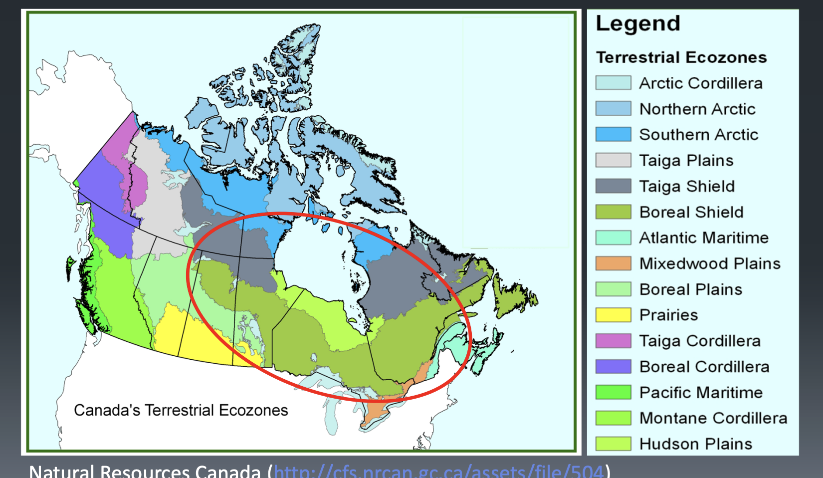
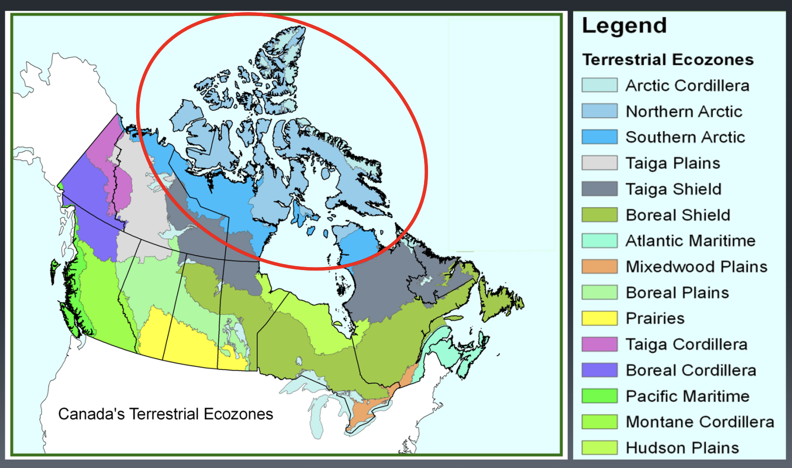
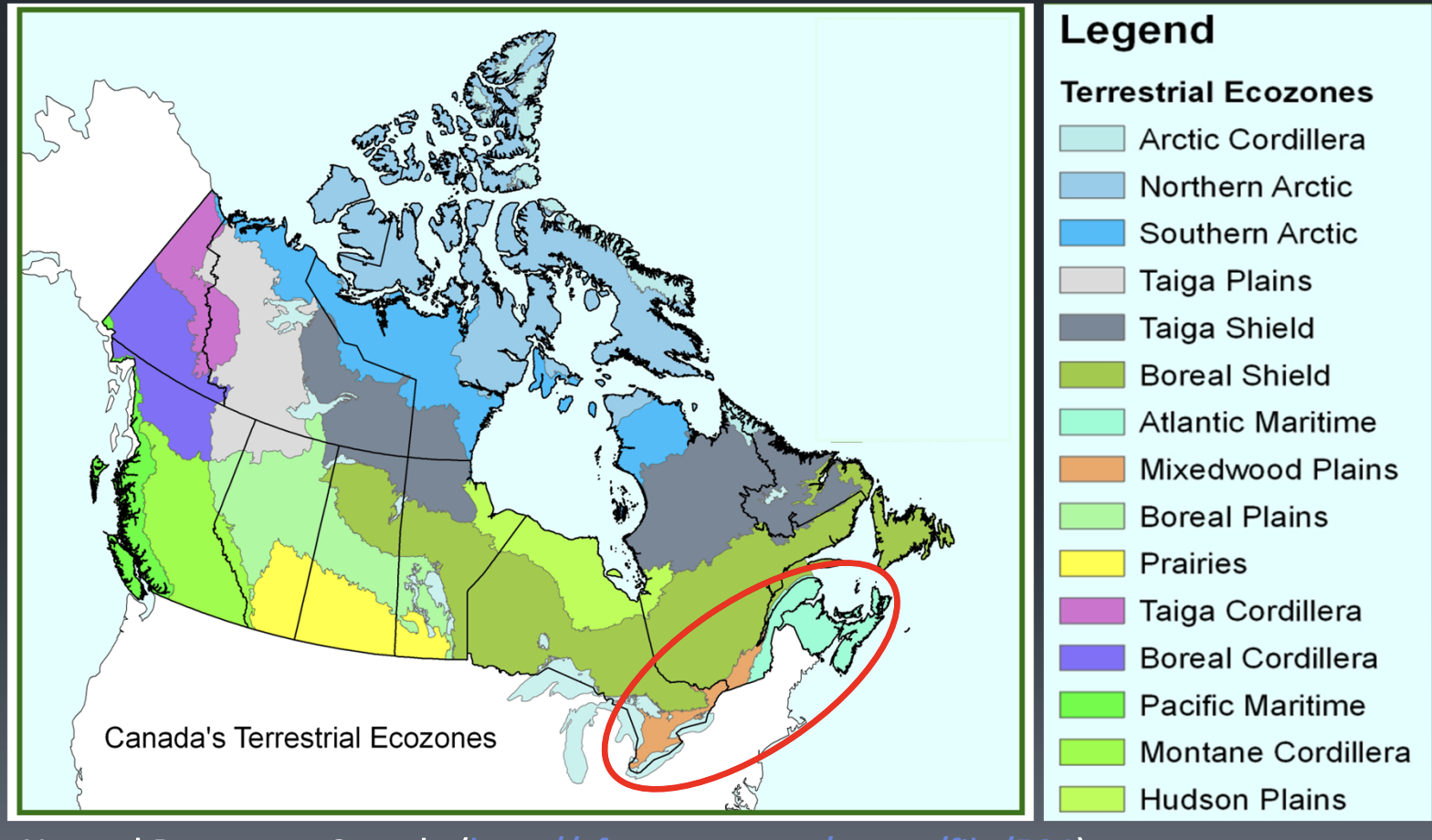
Canadian Ecozones
large ecological unit characterized by interacting abiotic and biotic factors
each has unique geology, climate, vegetation, wildlife and human factors
hierarchical (ecozones => ecoprovinces => ecoregions)
used for reporting and planning
Determinants of ecozones
Climate, Geology, and Soils
Temperature
N-S gradient (day length and sun angle)
Location and continentality (coast vs inland)
Precipitation
Pacific maritime air masses and prevailing westerlies (name winds from direction wind comes from)
air masses from arctic (cold and dry) and gulf of mexico (warm and humid) collide along polar front
Canadian shield
lots of shallow bedrock which doesn’t break down into soils
low soils and lots of wetlands (water cant penitrate soils)
Mountain ranges
coastal (western canada)
rockies (east of coastal mountains)
Arctic (northern canada)
Boreal shield, Taiga shield, Hudson Planes
boreal forest dominated by coniferous species (white and black spruce) (foundation is wetlands and bogs)
Canadian Northern Shield, exposed rock and permafrost
wetlands and bogs
The south has deeper soil, and glaciers left more sediment
Arctic cordillera, Northern and Southern arctic
non forested tundra
high latitude , low solar evergy
low ppt but humid
permafrost prevents perculation into soil = abundant surface water
little water avail to plants, sparse vedge
Atlantic maritime and Mixed Wood Plains
Acadian forest
SE of cad shield
densley populated, settler impacts (forest heavily mod)
mixed forest
cooler wetter regions (maritime) with thinner soils (cad shield)
Great lakes- st lawrence and Corolinian Forests
SE of cad shield
densely pop , settler impacts (forest heavily mod)
dom by deciduous trees
warmer deeper soils (more inland and glacier deposits)
Prairies, Boreal, Taiga Plains
Grasslands and boreal forest
in rainshadow of rockies
glacial influence (topography, soils, wetlands and lakes)
S-N gradient (Grasslands => parkland=>forest)
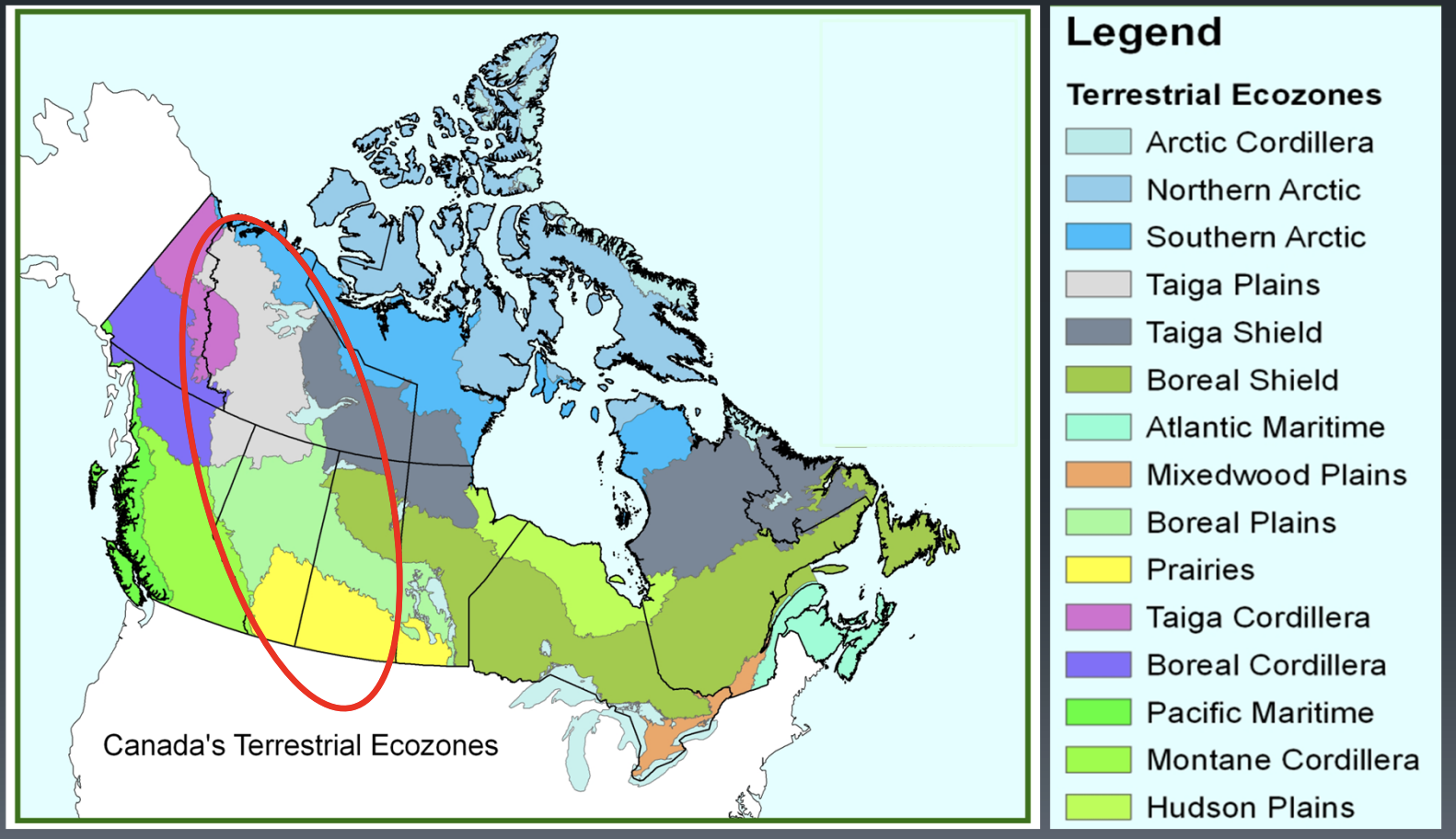
Pacific Maritime, Montane, Boreal, Taiga Cordillera
Coastal, Montane, and Subalpine Forests
western cordillera (all mountain ranges of western canada)
temp gradient (S-N) (north is cooler with latitude)
elevation gradient (cooler and moist higher)
precipitation gradient (W-E) (higher ppt in west)
Diverse topography
big change of climate over short different
diverse vegetation
diversity effects human impacts (valley bottoms, farming)
Canadian national forest inventory
established between 2000 and 2006
ongoing monitoring of forests provides info on state (conditions) and sustainable management of canadian forests
covers 12 forested ecozones (out of 15 total)
network of permanent plots (remeasure same plots) every 10 years
plots cover 1% of land mass
ground plots, photoplots, remote sensing data plots
provides dominant species, volume, tree ages, and land use
How mix of plots are used together?
Remote sensing surveys
grid network of “photoplots” from satalite and aerial imagery
field surveys
“ground plots” cover 8% of photoplots
big enough to capture variation
We use a mix of both. We use ground plots to understand and reassure our photoplots. Remote sensing allows for field plots to be continuous from detailed field measurements
Why is an ongoing forest inventory important?
early identification of insects and disease for forest protection
monitoring of harvesting patterns, ensures sustainable logging
long-term land-scaping planning, what to conserve vs harvest
quantification of carbon sequestration, track carbon storage
Orographic effects (mountains and their positions)
vegetation effected by climate
high variation of climate and vegetation in mountaneous ares
as elevation increases, temp decreases and vise versa
Environmental lapse rate
non moving air
decreases at 6.4 degrees Celsius/ 1000m
Names of sides of mountain when wind is present
wind hitting side = windward
opposite side = leeward
orographic uplift
after wind hits windward side of the mountain, it gets pushed up by slope
adiabatic cooling
as air is pushed up mountain by orographic uplift, it expands and cools
less pressure
adiabatic warming
as air desends on leeward side of mountain it compresses and warms
highh atmospheric pressure and higher temp
relative humidity
% of water air has from its water holding capacity (ie has 40% of total capacity filled with water so 40% RH)
amount of water vapor present/amount of water vapour the air can hold
as temperature decreases, the air can hold less water and relative humidity increases
as air temp decreases more the air is fully saturated of water and cannot hold more = 100% relative humidity
at 100% RH theres potential for ppt
absolute humidity
amount of water vapour in air
Dry adiabatic lapse rate
if air has less than 100% RH
the rate of warming/cooling is 10 degrees celcius/1000m
Moist Adiabatic Lapse rate
as air mass cools, it can hold less water, reaches 100% RH
as it condenses, heat evergy is released
cools at 6 degrees celcius/1000m
elevation effects on climate
high elevation
colder (low atmospheric pressure)
wetter (orographic ppt)
Low elevation
warmer (higher atmospheric pressure)
dries (less than 100% RH)
how temp varies in BC
varies with latitude (suns solar E) and longitude (ocean)
varies with elevation (cooler higher, less pressure)
blanket of clouds holds in heat overnight
Precipitation causes
caused when water condenses in air when air is cooler below its dew point and falls due to gravity
4 types of ppt caused by uplift
1) orographic
2) convergent
3) convective
4) frontal
PPT - snow
snowpack abundance and persistence
effects water availibility => length of growing season
max at high altitude and latitude
higher in west, lower in east of BC
pos loop: high albedo, high reflection, low absorption of solar E, cooler temp, ppt as snow, more snopack, high albedo
latitude effect on temp
influences sun angle, day length, seasonality, temp gradient
longitude effects on temp
continentality and cloud cover
land vs water
in BC W => E gradient (maritime to conitinential)
Topography effect on temp
aspect- orientation relative to sun
elevation , temp down with increase elevation
PPT- orographic uplift
airmass from ocean is pushed up and over mountain from wind
releases ppt on windward side and then air goes east into rainshadow
PPT- Winter: convergent uplift
in low pressure system
warm and cold air air masses converge at ground level , they rise and water vapour condenses
westerlies carry these moist airmasses onshore
high pressure blocks westerlies
PPT summer- convergent uplift
weaker low pressure
low pressure shifts north and BC is dominated by high pressure
vancouver- summer dry
Convectional uplift
continential climates in BC
surface heats up from sun and warms air around it
air rises leads to clouds and thunderstorms
summer - wet
frontal systems
“front” = zone of contact of 2 air masses of dif pressures
effects all parts of BC
dew point
temp at which relative humidity = 100%
at cooler temps, gas water condenses to liquid = cloud or fog and ppt can result
At a broad level how do topography and climate differ between
Wisconsin and BC?
Wisconsin is generally flat (due in part to glaciation), whereas BC is highly mountainous.
• Consistent climate across Wisconsin with only a minor temperature and precipitation gradient.
• BC climate can be highly variable in both temperature regime and precipitation amount.
• Wisconsin has a highly continental climate, while BC has a maritime climate on the coast and a
more continental climate in the interior.
From what you already know about the BEC system. How is the Wisconsin Habitat Classification
System similar to the BEC system?
Both strongly rely on soil characteristics, especially soil moisture regime (SMR) and soil nutrients regime (SNR).
• Both use understory indicator plant species to infer soil moisture and nutrient levels
• Habitat types (forest ecosystem types) are based on regional climates and then variation in local conditions (especially related to soil)
From what you already know about the BEC system. How is the Wisconsin Habitat Classification
System different from the BEC system?
Wisconsin’s system is much simpler because its of relativity homogenous climate.
• Wisconsin’s system doesn’t directly examine soil.
• Wisconsin’s system has greater focus on multiple successional pathways for a given habitat type
climographs
graph which shows climate (temp and ppt) of area
BEC
Biogeoclimatic Ecosystem classification in BC used to classify forest ecosystems
Zonal classification
hierarchical system for classifying climate in BC
biogeoclimate units
(zone+subzone+{varient}+{phases}
characterized by similar climates
can recognize based on vege in field
what are the hierarchical levels based on
zone- vegetation
subzone- plant associations’varient- variations due to topography and soils
“zonal” sites
average and representative
vegetation is just based on climate (not soils or aspect etc)
site series (01)
minor variability due to topography (moderate slope, aspect and location)
Specific site conditions within a BEC zone
Used as the reference site to describe what the zone is like
coastal zones
mod by pacific ocean
rainshadow of mountains
altitudinal gradient (elevation)
orographic effects
southern interior
rainshadow of coastal range
low latitude in BC
strong altitudinal gradient and orographic effects
northern interior
rainshadow of coastal range
hjigh latitude in BC
strong alt gradient and 0rographic effects
continentality
how to name zones
ZONEyz
yz are subzone
y= ppt regime
x=v dry, d=dry, m=most, w=wet, v = very wet
z=temp regime(interior), Coastal zones(continentality
interior temp regime
h=hot, w= warm, m=mild, k=cool, c=cold, v= very cold
continentality of coastal zones
h=hypermarine, m=maritime, s=submaritime