Glaciers
1/43
There's no tags or description
Looks like no tags are added yet.
Name | Mastery | Learn | Test | Matching | Spaced | Call with Kai |
|---|
No analytics yet
Send a link to your students to track their progress
44 Terms
definition of a glacier
a large mass of ice on land that shows evidence of motion.
how can ice be viewed as a igneous, sedimentary, and metamorphic rock?
igneous - forms from melt that has undergone cooling and recrystallization
sedimentary - deposition of snow in layers
metamorphic - Ice recrystallizes under pressure and deforms by plastic flow.
unique properties of ice
Freezes at a low temperature compared to silicate rocks
Less dense than liquid water → floats in water
Much weaker than most rocks → flows under stress
Can deform plastically over geologic timescales
Describe the steps of the formation of glaciers
1) Snow falls and accumulates in layers
2) Pressure causes recrystallization
3) Pressure from overlying ice causes air to be squeezed out
4) Ice becomes dense enough to flow like a viscous fluid
describe the compaction stages and the proportion of air at each stage
loose snow (~90% air)
Granular snow (~50% air)
Firn (~25% air)
Fine-grained ice
Coarse-grained ice
conditions required for glacier formation
Cold local climate (requires polar latitudes or high elevation)
adequate snowfall: snow accumulation must exceed melting rate. polar regions tend to be dry; wet (windward) sides of mountain ranges
Snow must not be removed by avalanches or wind
Valley (aka Alpine, Cirque, or Mountain) Glaciers
Flow down mountain valleys
Confined by topography
Flow like rivers of ice
Carve landscapes between mountains
Continental Glaciers (ice sheets)
Cover large areas of land
Flow outward from thickest center
Two modern examples:
Antarctica
Greenland
ice caps
cover mountain peaks and ridges
piedmont glaciers
large, fan-shaped lobes of ice that form when valley glaciers spread out from confined mountain valleys onto a broad, flat plain
ice shelves
Floating extensions of continental ice sheets
Still connected to land-based ice
Tidewater glaciers
Valley glaciers that terminate in the ocean
Produce icebergs via calving
sea ice
sea ice is NOT glaciers
Forms from frozen seawater
Does not contribute to sea-level rise when melted
accumulation
ice growth by snowfall
ablation
shrinkage by melting, iceberg calving, sublimation, wind erosion
glacial budget
glacial budget = accumulation - ablation
if accumulation > ablation: advance, erosion of landscapes, cooling climate
if accumulation < ablation: retreat, deposition of sediment, warming climate
if accumulation = ablation: ice front remains in the same position
Advance
More snow falls and compacts into ice than melts away; the glacier flows forward, extending its terminus.
Retreat
More ice melts than is gained; the terminus recedes, even though ice still flows from the accumulation zone down the glacier like a conveyor belt.
what is the typical speed of glacial motion per year?
ranges from ~10 to 300 meters per year
what factors does glacial flow speed depend on?
ice thickness: thicker ice creates more pressure and greater basal shear stress → faster movement
slope: steeper slope → faster flow speeds
temperature: temperate glaciers move faster due to basal slip
meltwater at the base: the presence of liquid water at the glacier's base acts as a lubricant enabling basal slip
compare glacial flow in temperate (warm) glaciers vs. cold glaciers
temperate ice deforms more easily and has a lower viscosity than cold ice → enables basal slipping.
Cold ice is more rigid and deforms much more slowly, with movement primarily due to internal plastic flow
two main mechanisms of glacial flow
Basal slip
Plastic flow
basal slip
Pressure from overlying ice lowers the melting point of ice
Basal ice melts, producing water
This water acts as a lubricant, reducing friction
The glacier slides over the underlying rock
where does basal slip dominate?
Temperate (warm) glaciers
Valley glaciers
Regions where summer melting is common → flow rate often increases during summer
plastic flow (internal deformation)
the slow movement of ice caused by deformation and recrystallization of ice crystals within the glacier. occurs throughout the ice mass.
Ice crystals deform under stress
Crystals slip along microscopic planes
Recrystallization allows ice to change shape without breaking
Ice flows like a very viscous fluid
glaciers are frozen to the bed at their base
where does plastic flow dominate?
Cold, dry regions (where basal slip is impossible because they are frozen to the bed at their base)
Continental ice sheets (e.g., Antarctica)
what is the equilibrium line?
separates the zone of accumulation (above) from the zone of ablation (below).
what happens to the equilibrium line when the glacier is advancing vs. a glacier retreating?
dvancing glacier → equilibrium line moves down
Retreating glacier → equilibrium line moves up
Abrasion
rock fragments scrape bedrock
plucking
ice pulls away fractured rock
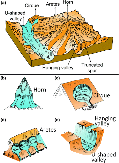
glacial erosion landforms
U-shaped valleys
Hanging valleys
Cirques
Arêtes
Horns (e.g., Matterhorn)
Roche moutonnée
Striations (flow indicators)
Fjords (drowned U-shaped valleys)
describe the glacial “conveyer belt”
Sediment falls on ice
Sediment is plucked from bed
Transported to toe of glacier
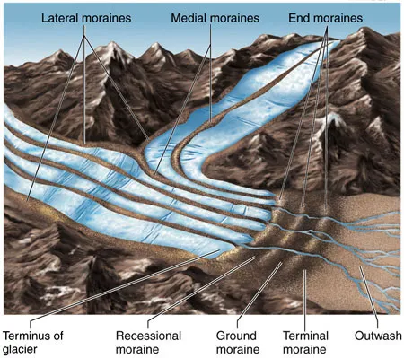
identify 4 types of deposits
till: unsorted debris dropped by ice
stratified drift (outwash): sorted by meltwater into layers
erratics: large, out-of-place boulders
varves: annual sediment layers (e.g. mud deposited in glacial lakes) that act like natural calendars because the summer and winter layers are distinct
Moraines
long, rough ridges of rocky debris (till)
lateral moraines: Run along the sides of a valley glacier
medial moraines: Run down the middle of a glacier, forms where two glaciers merge
terminal moraines: Found at the downhill end of a glacier
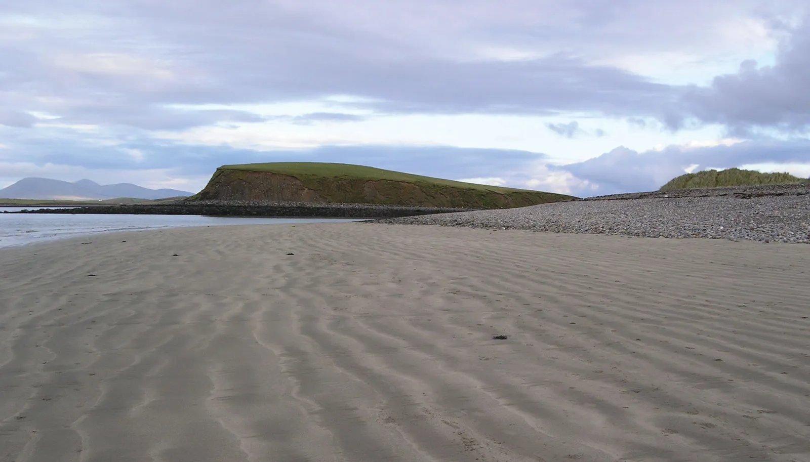
Drumlins
elongated hills of till
steep and blunt, the other end has a gentle slope
all drumlins in an area point in the same direction
Esker
Eskers are long, narrow, winding ridges of sand and gravel
look like a river made of sediment
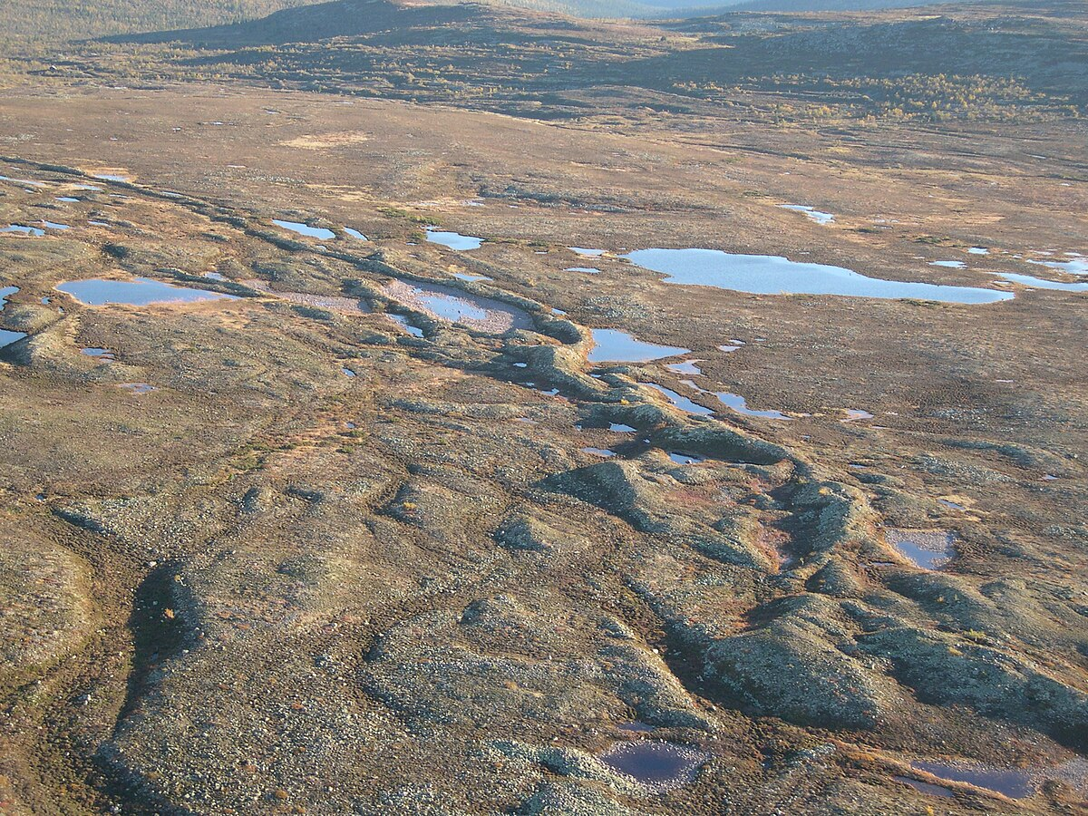
Kettle Holes or Kettle Lakes
Shape is typically circular or bowl-like; Formed when buried ice blocks melt
Dry kettle: shallow pit or hollow
Kettle lake: depression filled with water
what does Eustatic Sea-Level Change mean?
global changes in sea level that affect all oceans worldwide. These changes occur when the total volume of water in the oceans changes
3 controls on Eustatic Sea-Level
Ocean Water Quantity (glacial ice volume): When more water is stored as glacial ice on land, less water is in the oceans
ocean water volume (thermal expansion): Water expands when it warms and contracts when it cools Warmer ocean water has lower density and takes up more space
ocean basin volume (plate tectonics): Changes in seafloor spreading rates or basin shape can alter how much water the oceans can hold
how can sea levels rise without any water being added?
Even without adding water, warming oceans cause sea level to rise because warmer water causes ocean water volume to expand. Water expands when it warms and contracts when it cools
Principle of Isostasy
Earth’s crust “floats” on the mantle, similar to how ice floats on water.
It is based on Archimedes’ principle: The weight of a floating solid (Earth’s crust) equals the weight of the fluid (Earth’s mantle) it displaces.
The immense weight of ice sheets pushes the crust down into the mantle
When glaciers melt, the crust rebounds upward (uplift)
glacial isostatic adjustment (GIA)
process of when glaciers melt, the crust slowly rebounds upward (uplift)
what is relative sea level (RSL) and what 2 factors does it depend on?
Relative sea level (RSL) is the sea level measured relative to the land at a specific location.
RSL is determined by 2 factors:
global eustatic sea-level changes caused by ice volume, ocean temperature, and basin size
local land elevation changes caused by glacial isostatic adjustment.
equation for relative sea level
RSL = global sea level (eustatic fluctuations) — the local land elevation changes (isostatic fluctuations)
*Sea level can rise globally but fall locally if land is uplifting