Geography - Glaciers
1/188
Earn XP
Description and Tags
Pearson Edexcel A-Level Glaciation Notes
Name | Mastery | Learn | Test | Matching | Spaced | Call with Kai |
|---|
No analytics yet
Send a link to your students to track their progress
189 Terms
4 types of cold environment
tundra/periglacial
polar (land) e.g. large masses of ice
polar (marine) e.g. icebergs
alpine (mountains)
cryosphere
all locations on Earth where water is in its solid state (can be permanent or temporary)
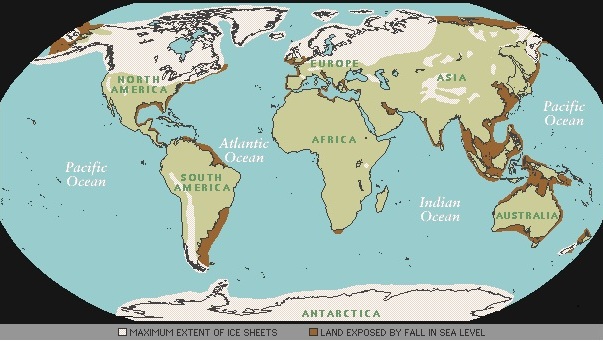
Largest ice mass
Antarctica (85%) and Greenland
The Quaternary period
covers the most recent period of geological time (2 million years ago → now so including the Pleistocene and the Holocene)
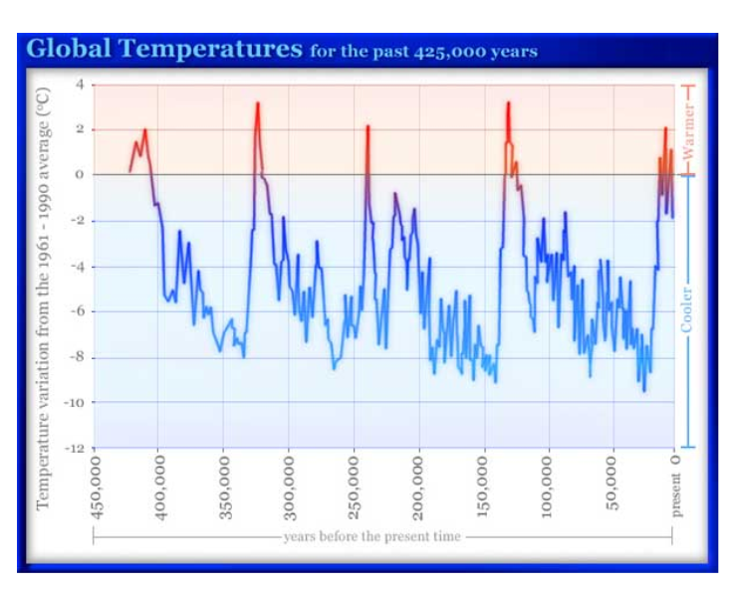
last glacial stage
Devensian period
pleistocene
the last ice age
holocene
warm period since 12000 years ago
the Milankovitch cycle causing climate change
the theory states the amount of solar energy reaching the earth’s surface varies with the shape of the Earth’s orbit around the sun, the angle of the tilt of the earth’s rotation and the direction of the axis of rotation
how does shape of orbit affect climate change
every 100,000 years the shape changes from circular (glacial phase) and elliptical (interglacial phases as closer proximity to the sun in summer months)
how does obliquity (tilt of Earth on its axis) affect climate change
varies from 21.8 degrees to 24.4 degrees over a 41000 timescale - when the tilt is greater, the seasons are longer so increased melting so interglacial period
how does procession (the earths ‘wobble’) affect climate change
change in direction of rotation every 19000 - 23000 years and can be used to explain the smaller increases and decreases
tectonic movement causing climate change
caused the Pleistocene (2.5 million yrs ago) - when N.America and S.America joined which pushed warm water northwards → more moisture from evaporation → more snow in N. hemisphere
albedo causing climate change
once ice sheets begin to develop, the Earth’s albedo (reflectivity) increases as ice is very reflective of solar energy → leads to a further decrease in temp
thermohaline circulation causing climate change
a slow, pattern of flow involving surface and deep ocean currents which is driven by differences in the density of sea water (which is controlled by temperature and salinity) → warm currents may keep some areas warmer e.g. UK
volcanic eruptions causing climate change
when a volcano erupts it releases ash into the atmosphere and when this ash reaches the stratosphere it stays suspended and reflects incoming solar radiation, causing average temps to drop e.g. Mount Tambora caused ‘the year without summer’
sunspot cycles causing climate change
every 11 years the sun changes its magnetic poles causing sun spots which make the earth warmer. They are bursts of energy where the sun emits a high amount of radiation
maunder minimum
name for when there is a lower number of sun spots
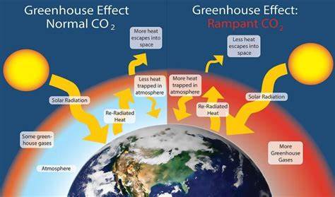
carbon dioxide levels causing climate change
greenhouse gas which is increased due to industrial revolution and population increase (increase energy reliance so increase burning of fossil fuels) prevents solar energy from leaving the atmosphere
food production causing climate change
produces large amounts of greenhouse gases from the clearing of land to make way for crops and agriculture, growing of food, processing, packaging and transporting it
(1/4 of global greenhouse gases from agriculture and food production)
deforestation causing climate change
trees capture CO2 and remove it from the atmosphere and so this is reduced when trees are removed but they also store the CO2 in trunks so when deforested, they release this extra CO2
burning of fossil fuels causing climate change
release of greenhouse gases like CO2 and sulfur dioxide which has a cooling effect on the planet as they reflect incoming solar radiation (key to slowing down climate change)
tree trunks being evidence for climate change
cross-sections where each ring represent a year of growth - this growth is effected by climate as thicker = warmer and wetter (up to 10,000 yrs ago)
ice cores being evidence for climate change
ice sheets build up over approx. 1 million years and we can drill down and collect ice cores which contain tiny bubbles with samples of the environment at that time e.g. CO2 levels
micro-fossils being evidence for climate change
skeletons of tiny, single celled creatures called foraminifera which live in oceans - they build up in layers and can by dug up - different species prefer different climates
weather stations being evidence for climate change
contain:
thermometers - indoor and outdoor temp
lux metre - solar energy
anenometer - wind speed and direction
barometer - air pressure
rainfall gauge
Loch Mond Stadial (stadial = short-term cooler phase within a generally warmer climate)
caused the reemergence of ice over Scotland - caused by sunspot cycles or volcanic eruptions
Little Ice Age
Thames froze and had frost fairs on top - caused due to the Maunder Minimum - virtually no sunspot activity
glacier
an accumulation or large mass of ice moving down due to gravity as well as its own weight
unconstrained glaciers
glaciers that have a morphology (form, shape and structure) and flow pattern that is independent of underlying topography (land beneath)
constrained glaciers
glaciers that have a morphology and flow pattern which is strongly dependent on underlying topography
alpine glaciers
high altitude so cold conditions and air of a lower pressure (every 100m increase = temp drops by 0.6 degrees) so increased glacier growth and causes valley glaciers e.g. Himalayas
polar terrestrial
very high latitude (colder as the angle or insolation means weaker sunlight is used to heat a larger area so less concentrated), forms ice sheets e.g. Antarctica, Greenland
polar marine
high altitude (sea will freeze) forming sea ice which is NOT a glacier (sea ice = dense ice that floats on the sea)
tundra
high latitude but not always ice covered due to low precipitation. Ground is frozen without ice = permafrost e.g. North Canada, Alaska
cirque (‘corrie’) glaciers
form as mountain side hollows and are found in nearly all alpine landscapes that support ice accumulation
localised to all arm-chair shaped bedrock on a mountain side
valley glaciers
exist within bedrock valleys and are overlooked by ice-free slopes (found in many alpine environments). They have high erosive power and are fed in the upper parts by ice and snow from tributary glaciers
ice sheets + ice caps
confined to Antarctica and Greenland as both are broad and have slowly moving ice domes at their centre. They almost completely submerge the landscape with only the tips of mountain peaks piercing the service
ice caps are smaller
snow
90% air
coarse-grained snow
50% air
firn
20-30% air
glacial ice
20% air as bubbles (10-20 years)
accumulation
the amount of mass/snow added to a glacier e.g. through snowfall, avalanche, tributary glaciers, wind blown snow and rain
ablation
the total amount of ice that a glacier loses each year e.g. through melting (above 0 degrees celcius), calving (a section of a glacier breaks off) and sublimation (ice → gas)
snow line
the lowest edge of permanent snow cover in a mountainous area (warm summers = higher snow line)
glacial budget
the difference between accumulation and ablation in one year (positive or negative)
examples of disappearing glaciers
Columbia Glacier, Alaska - retreated over 12 miles since 1980 (max 5km in 1 year) as tide-water causes huge icebergs to carve away daily
Kalis Glacier, Peru
temperate glaciers
warm based
move far more quickly as ice isn’t frozen to the bed (through basal sliding as -1 degrees at base)
high accumulation and ablation
mobile glacier and therefore = erosion
moves 2-3m/day (100x polar glacier)
e.g. Himalayas
polar glaciers
cold based
move very slowly (1-2cm/day) as frozen to the bed (-30 degrees at base(
ice moves by inter-granular movement
ablation and accumulation limited
little erosion or deposition as little debris carried
pressure melting point not reached = no basal sliding
brittle zone
crevasses form as the ice fractures due to there not being enough pressure for the ice to be flexible
plastic zone
ice is flexible as higher pressure
basal sliding
responsible for 80% of glacial movement but only found in temperate glaciers
as pressure increases, the pressure melting point of ice lowers meaning ice melts at the -1 degree temperature at the base of most temperate glaciers
produces meltwater which lubricates the ice, meaning it slides over the rock below
(crevasses can also fill with water which can drip down and increase meltwater)
intergranular movement/laminar flow
occurs in every glacier but specifically polar glaciers as the bottom layer is frozen to the ice which cannot move
the higher the layer, the further the ice will move over the top of the layers below
can form crevasses due to tensions of layers of ice moving at different speeds
extending flow
when ice goes down a steeper gradient, it accelerates causing crevasses to form as the ice begins to thin
compressing flow
ice goes over a flatter gradient causing it to slow down which causes the ice to thicken and increase in depth
forms concentric ridges at the snout called compressional ridges as ice bunches as it slows down
rotational flow
only occurs in corrie/cirque glaciers
ice rotates around a pivot point which increases the pressure at the bottom of the bowl
this causes erosion and in turn the glacier to deepen
regelation slip
when a glacier approaches an obstacle, there is an increased pressure on the stoss side as the ice hits it
this causes the pressure melting point to lower which increases melting and meltwater produced
this causes the velocity of movement over the obstacle to increase but as it starts to move away over the leeward side, the pressure decreases and refreezing occurs
as the ice freezes onto the rock on the leeward side, when it breaks free it may pluck some rock off with it
glacial surge
occurs when
a sudden release of meltwater occurs
the gradient suddenely becomes very steeo and ice mass is high
the loss of a snout which acted like a blocker
velocities reach 10-100x faster than normal
very rare
how does gradient affect rate of movement
higher gradient = higher momentum so faster
if going uphill = much slower as going against gravity
glacial surge = more likely to occur if gradient suddenly becomes very steep
how does temperature affect rate of movement
high temperatures = high melting = more meltwater = faster basal sliding
how does precipitation affect rate of movement
increases accumulation = lowers PMP = increased melting = faster basal sliding
fills crevasses and drips down = increased lubrication = more basal sliding
how does rock type affect rate of movement
impermeable rock e.g. granite = water cannot pass through = rock is more lubricated = faster basal sliding (opposite for permeable rock)
how does mass of ice affect rate of movement
higher mass = heavier = more momentum = quicker
decreases PMP = more melting = more meltwater = better lubricated = moves quicker by basal sliding
entrainment
small rock fragments are trapped by basal ice freezing around them and applying sufficient drag to pull them along
subglacial
environment beneath the glacier ice
proglacial
environment located at the front of a glacier
periglacial
environments near glaciers
supraglacial
on top of the ice
englacial
within the ice
abrasions
when entrained rocks slide along the bedrock, eroding the bottom and side through scratches
striations
large scar
factors affecting abrasion
speed of glacier movement (slower = more abrasion)
supply of debris (more erosion as more friction)
subglacial meltwater (more = increases speed of movement due to basal sliding = less abrasion but plucking)
ice thickness (thicker = higher pressure at base so more abrasion)
rock type (hard bedrock erodes more slowly as requires a rock of similar density)
shape of debris (sharp/jagged may erode more + bigger = more erosion)
plucking
ice pulling rocks off of bedrock as it flows over (when meltwater refreezes and the ice moves, it pulls pieces of rocks off) causing bumpy and jagged rocks
freeze thaw weathering
when meltwater or rain gets into cracks in the bedrock, it freezes and expands causing the cracks to get larger causing the rock to break away
v-shaped valleys
shallow, steep straight sides
green from trees and vegetation
often has interlocking spurs
may have more rivers/lakes
u-shaped valleys
deep and wide u-shaped valleys
rockier and less green
“misfit stream” within the valley
truncated spurs
ridges called aretes between valleys
corrie
a bowl shaped hollow in a mountain side which is scooped out by the process of abrasion from a glacier (rotational flow)
e.g. Red Tarn
corrie formation
snow compacts to ice and flows within a hollow in the mountain side
the rock above the glacier is weakened by freeze-thaw weathering, adding rocks to the glacier
hollow is made deeper by abrasion, plucking and rotational flow
the glacier melts so corrie is revealed (tarn if water fills the hole)
aretes
narrow ridges of rock formed where two glaciers erode a valley, side by side or back to back producing two steep sides on either side
e.g. Striding Edge
aretes formation
formed when two corries erode towards each other
pyramidal peak
the central mass of rock which is left on the mountain as 3 or more corries erode backwards into it (also forms aretes)
e.g. the Matterhorn
glacial troughs
u-shaped valleys with steep sides and a flat floor due to the high erosion power of ice
often contain a ‘misfit stream’ where a stream or river is much thinner than the valley floor
formed by weathering, erosion and transportation
ribbon lakes
elongated lakes which fill sections of the valley floor of a glacial trough and form due to the valley having a stepped profile
e.g. Ullswater
truncated spurs
where previous interlocking spurs are eroded back due to glaciers abrading the sides of the valley, creating jagged spurs as they no longer interlock
hanging valleys
where a smaller side valley is left ‘hanging; above the main U-shaped valleys as glaciers in the smaller valley are not as powerful so don’t erode as deeply
roches moutonees
where a protruding section of resistant bedrock is eroded creating an irregular shape
knock and lochan
large-scale feature covering extensive areas as a result of ice sheet scouring
formation of knock and lochan
created where ice sheets have weaker and stronger rock (weaker rock erodes faster) which forms the ‘lochan’ meaning lakes and the harder rock that is left over is known as ‘knocks’
found across Scotland
crag and tail
where a resistant area of bedrock forms an obstacle and plucking and abrasion erodes the stoss side and then sub-glacially transports this material to be deposited on the leeward side
the ‘crag’ is the bedrock and the ‘tail’ is the deposited material streamlined by subsequent ice flow
e.g. Edinburgh
striations
micro-scale feature formed when rock entrained in the ice is harder than the bedrock causing it to gauge out a groove/scratch parallel to ice flow
chattermarks
micro-scale feature which is horse-shoe shaped mark in bedrock formed by sub-glacial rocks jolting or juddering forwards in sudden movements
moraine
any material a glacier is carrying or has carried and deposited (unsorted and unconsolidated)
active/inactive depends on whether the material is currently being transported by the ice or not
erratic
a boulder transported and deposited by a glacier at a distance from its source which indicates patterns if former ice flow
how does material get deposited at the snout?
moves forward → pushes material proglacial further in front
retreats/melts → leaves material either entrained or supraglacial
till
racks deposited by ice/glaciers which is unconsolidated and unsorted
terminal moraine
a moraine ridge that marks the maximum limit of a glacier advance (at the end)
recessional moraine
found behind a terminal moraine limit and form during short-lived phases of a glacier advance or stand-still that interrupts the general pattern of glacier retreat (may be annually)
lateral moraines
forms along the glacier side and consists of debris that falls or slumps from the valley wall or flows supraglacially
medial moraines
debris ridges at the glacier surface running parallel to the direction of ice flow supraglacially
forms where lateral moraines meet at the confluence of two valley glaciers or where debris constrained in the ice is exposed at the surface due to melting
ground moraines
describes the uneven blanket of till deposited in the low-relief areas between more prominent moraine ridges
forms at the bottom of the glacier due to deformation and eventual deposition of sub-stratum (an underlying layer)
till plains
when an ice sheet retreats, large amounts of material are deposited over a sizeable area due to melting