Weather and Climate Study
1/59
There's no tags or description
Looks like no tags are added yet.
Name | Mastery | Learn | Test | Matching | Spaced | Call with Kai |
|---|
No analytics yet
Send a link to your students to track their progress
60 Terms
What is humidity
A measurement of the amount of water in the air
What is absolute humidity
Absolute humidity is the density of the water vapor (How much water vapor is in 1m³ of air)
What is specific humidity
The mass of the water vapor vs the total mass of the air
What is the saturation specific humidity
The maximum amount of water vapor that can be in a certain volume of air at a given temperature
What is the relative humidity
It is the amount of water vapor in the air vs how much there could be
What is the pattern of humidity vs temperature
As temperature increases, humidity typically decreases
What is Dalton’s Law as related to vapor pressures
The individual vapor pressures added together make up the total vapor pressure in a certain amount of air
What is saturation vapor pressure
The maximum vapor pressure that can exist at a certain temperature
What is the dew point
The temperature at which the air will become saturated, it is always equal to or lower than the temperature never higher
What are the seasonal humidity patterns
The colder seasons are a lot more humid than the warmer seasons
What is a diabatic process
A process that adds or removes energy directly changing the heat of an object
What is an adiabatic process
A process that will cool the air or heat it without adding or removing energy to the air
What is an air parcel?
It is a theoretical amount of air that is used to demonstrate how air behaves in the atmosphere
What is the Dry adiabatic lapse rate
The constant rate at which air cools as it ascends into the atmosphere
What is the environmental lapse rate
The actual rate at which air cools as it ascends
What is the lifting condensation level
This is the altitude at which the air parcel is cooled to the dewpoint and becomes saturated following the saturated adiabatic lapse rate
What are the 4 methods to lifting air? and are they adiabatic or diabatic?
Oreographic lifting: When air is forced upwards by terrain and cools and condenses, one side will get a lot of clouds but on the opposite side the air will warm and become unsaturated, creating a rain shadow making the other side have very little rain. This is adiabatic
Frontal lifting: This occurs when fronts collide and the warm front is forced into the air and condensed forming stratiform clouds (Only on a warm front). A cold front is when a cold front is the aggressor, and a warm front is when a warm front is the aggressor. This is adiabatic cooling
Convergence: This occurs when an area of low pressure has winds from high pressure areas converging at the low pressure area, and when these winds from different directions collide they lift themselves up and condense creating clouds, this is adiabatic
Localized convective lifting: Different surface temperatures cause different air temps and the higher temps are lifted creating updrafts, this is a diabatic process
What is the measure of how stable an atmosphere is
it’s tendancy to resist vertical movement
If there is a larger lapse rate what is the air said to be?
Statistically unstable
Is the SALR constant?
No it depends on the temperature of the air parcel, the higher the temp, the lower the lapse rate
At what point in the ascent of air does the lapse rate decrease
The moist ascent since moist air cools slower than dry air
When the air is stable what is the relationship between the DALR and the ELR
The relationship will be that the DALR is greater than the ELR
What is the relationship between the SALR, DALR, and ELR when the air is absolutley unstable
The ELR will be greater than the SALR and the DALR
What is the relationship between the SALR, DALR, and the ELR when the air is conditionally unstable
SALR<ELR<DALR
Do all clouds form percipitation, and why?
No, this is due to the size and slow fall rates of some clouds which makes it so the droplets cannot get big enough to fall
What needs to happen to a cloud droplet for it to become percipitation?
The droplets need to collide with other droplets very quickly and have a fast growth rate
What are the forces that act on cloud droplets that determine if they can fall
Gravity, which pulls the droplet down, drag, which keeps the droplet in the air, and the updrafts, which the droplet needs to grow to very large sizes to be able to reach a velocity high enough to overcome
What is supersaturation?
This is when the RH exceeds 100% typically by 1% and this helps form very big droplets
What are the 3 ways droplets can grow
Growth by condensation
This occurs when the air cools and saturates at a certain altitude, and this can produce clouds but typically is a method that is too weak to produce percipitation
Growth by warm clouds
In these types of clouds, they are warmer than 0C, this makes it so there are big updrafts that bring the water molecules up causing them to collide with other droplets, these other droplets either get pushed away or stick to the collector drop causing it to grow and fall as percipitation
Growth by cool and cold clouds
Cool clouds are clouds that are very big like towering cumulonimbus and have parts at the bottom which are not freezing but are freezing at a certain point and up
Cold clouds are entierly freezing clouds
In these clouds, the freezing parts have supercooled droplets which are freezing but they dont freeze due to no condensation neuclei, this makes it so when they collide with an ice crystal they will stick to it and freeze creating snow, or sleet
This is called the Bugeron Process
What is Riming
When supercooled droplets collide with ice crystals
What is Aggregation
When ice crystals join together at the tips where water molecules will stick
What is a drought and what is it caused by
Drought = long-term lack of precipitation
Caused by persistent high-pressure systems
Block clouds + rain
What are the types of energy in the atmosphere and how do they power the winds which drives all the weather?
Atmosphere powered by:
Potential Energy (PE) → stored (e.g., lifted air)
Kinetic Energy (KE) → motion (wind)
Continuous conversion keeps air moving
What is George Hadley’s single cell model?
It is a model that shows heating and rising of air at the equator which goes to the poles and cools and sinks back down which then travels back down to the equator.
This made winds that would flow from the poles to the equator which would also be deflected by Corrilis force, which makes the winds flow from east to west
This helped to develop an idea of how the general circulation works but was not that helpful
What are the 3 cells in the 3 cell model?
Hadley cell: This is the cell closest to the equator where air will rise at 0 and sink at 30 and the surface winds flow from the 30 to the equator causing easterly trade winds
Ferrel Cell: This is a weird cell driven by eddies which are distruptions of the normal flow and it flows like this, at 30 the air sinks and flows poleward until 60 which the air is driven up by the polar cell. This makes it flow different and produces the westerlies
The polar cell: It is the weakest cell that flows from 60 to 90 which is the poles. This air sinks at the poles and rises with the ferrel cell. The boundary at the polar and ferrel cells form a frontal zone called the polar front and is a place where a lot of storms take place
What are thermally direct and indirect cells
Thermally direct cells: These are cells that are driven by thermal action meaning air sinks at cold places and rises at warm places which makes the thermal energy convert to kinetic energy
Thermally indirect cells: These are cells that are driven by eddies and thermal cells like the ferrel cell where it flows opposite of the thermal cycle
What does the three cell model help to explain
It can explain the surface winds well but not really winds aloft
What are the doldrums and horse latitudes?
Doldrums are located at the Inter-Tropical Convergence Zone where warm air rises, and the horse latitudes are located at 30 degrees latitude or at the mid-latitudes where air sinks. Since the air is moving vertically in both it minimizes horizontal air movement making minimal wind and precipitation, causing deserts and conditions that are bad for sailing
What are Semi-permenant pressure cells
These are persistant high and low pressure cells that change with the seasons and do not move much. Examples include:
Alieutian low between alaska and russia
icelandic low at iceland
tibetan low near india
These lows are strongest during the summer and the tibetan one near india helps produce the monsoon there
Siberian High near West Russia and Siberia
Hawian high near hawaii
Bermuda-Azorez high between america and europe
These are strongest during the winter
Where do desserts form?
They like to form in places with little clouds such as places where air sinks like the midlattitudes, rainshadows, polar desserts, and costal places
What are jet streams?
These are small narrow streams at high altitudes in the westerlies that have very high wind speeds. This is caused by places of pressure differences and circle at the collision places of the cells like the polar jet stream and the mid lattitude jet stream
What are Rosby waves
These are waves that interfere with the smooth flow of the jet streams. These waves start out small due to temp. differences, the corrilis force, and eddies, which break the flow then the waves increase in amplitude forming troughs and ridges and they can even cuttof parts of the jet stream forming cyclones
These can cause storms, heat waves, and cold outbreaks
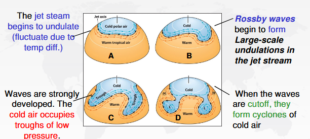
How does the winter affect Rosby waves
In the winter these temp. differences are way greater. This makes it so that the jet streams move even faster and while there are less troughs and ridges, they are larger and more intense
What are atmoshperic rivers
They are low altitude wind patterns that bring warm moist air towards the poles and create lots of rain
What is the ocean cirrculation and why does it matter?
Colder water lower in the oceans flows towards the surface and warmer water flows down to replace the colder water, this creates ocean currents which help regulate costal temperatures and ditruibute nutrient rich water equally
What is the Ekman Spiral?
A: A pattern where ocean currents change direction and slow with depth due to wind, Coriolis effect, and friction.
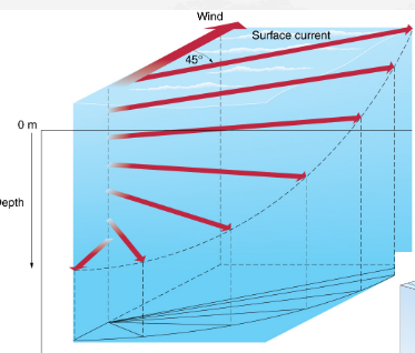
What is Ekman transport?
The net movement of water 90° to the wind (right in Northern Hemisphere).
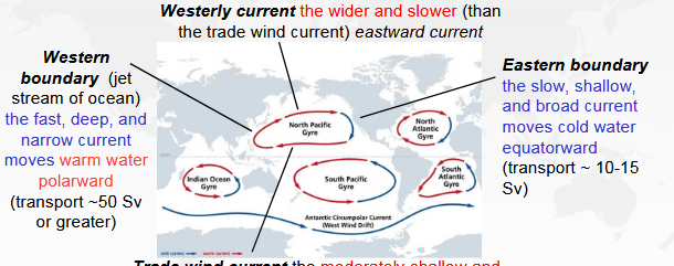
How do winds drive ocean gyres?
Trade winds push water west at low latitudes, westerlies push water east at mid-latitudes, and Ekman transport plus Coriolis create circular gyres.
What are monsoons
Seasonal reversals of winds, this is due to the land cooling faster than the sea in the winter but heating faster than the sea in the summer, this causes droughts and floods based on the wind patterns
Droughts are associated with the winter and floods are associated with the summer
What causes local winds? What are some examples?
Small-scale temperature and pressure differences. An example can be sea breezes during the day and land breezes at night
What is an air mass