AP HUG Review Quizlet Unit 6 Politics and Conflicts (40 Questions)
1/39
There's no tags or description
Looks like no tags are added yet.
Name | Mastery | Learn | Test | Matching | Spaced | Call with Kai |
|---|
No analytics yet
Send a link to your students to track their progress
40 Terms
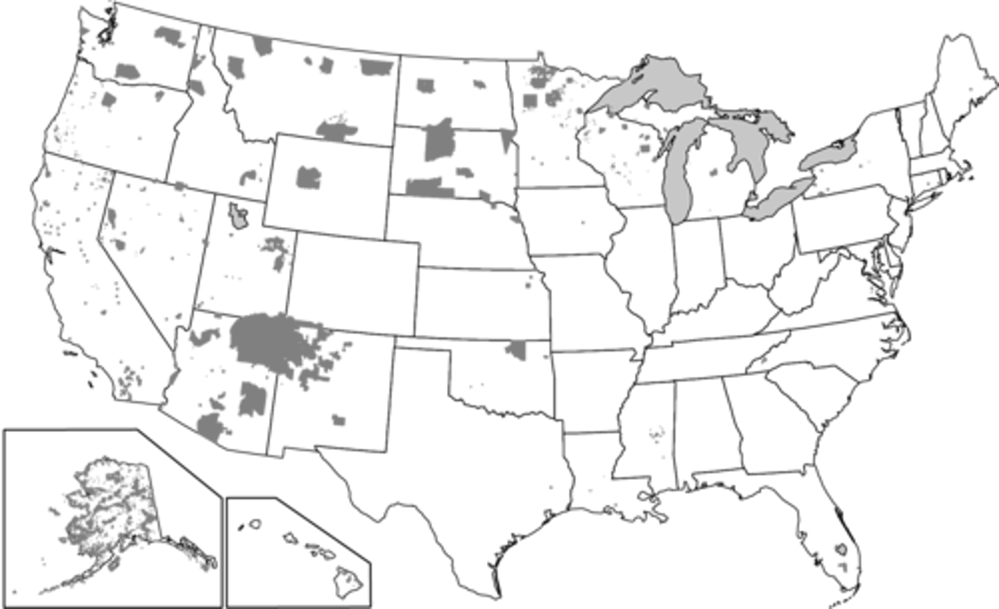
Which of the following best explains the governance of the shaded areas shown on the map?
a. These areas are established as nation-states for indigenous peoples at the local scale.
b. These areas show territory occupied by indigenous peoples as stateless nations at a local scale.
c. These areas show territory controlled by indigenous peoples as a single multistate nation.
d. These areas show where indigenous peoples have a limited amount of self-government at a national scale.
e. These areas are lands of indigenous peoples that are sovereign independent states at an international scale.
d. These areas show where indigenous peoples have a limited amount of self-government at a national scale.
Culturally defined political boundaries, such as those determined by the spatial patterns of religion or language, are called ___
a. antecedent
b. relict
c. geometric
d. consequent
e. natural
d. consequent
In 1982 the United Nations Convention on the Law of the Sea (UNCLOS) established freedom-of-navigation rights and defined territorial waters as a 12-nautical-mile limit from the coast where individual states have political and economic sovereignty. However, Greece and Turkey still only claim a 6-nautical-mile territorial sea.
What do the maps indicate regarding the political geography of the Aegean Sea?
a. Turkey and Greece share control of most of the islands in the Aegean Sea.
b. Greece controls most of the islands in the Aegean Sea.
c. Turkey controls all access from the Dardanelles to the Mediterranean Sea.
d. Greece controls all access from the Aegean Sea to the Black Sea.
e. Turkey controls most of the islands in the Aegean Sea.
b. Greece controls most of the islands in the Aegean Sea.
Which of the following describes a unitary form of governance?
a. A collection of independent communities shares government services.
b. Stronger states and transnational corporations indirectly control weaker states.
c. A sense of unity, often derived from ethnic or cultural traits, binds a country together.
d. A state has a strong central government with no power given to regions.
e. A state's more powerful central government shares power with its regions.
d. A state has a strong central government with no power given to regions.
Which of the following is an accurate comparison of devolutionary movements in Spain and Canada?
a. Both independence movements focus on religious differences with the nations they currently belong to.
b. There is an economic aspect to the Quebecois independence movement, while the Catalans focus mainly on culture.
c. Both independence movements utilize economic power as their main reason for seeking independence.
d. There is an economic aspect to the Catalan independence movement, while the Quebecois focus mainly on cultural differences.
e. Both independence movements utilize cultural distinctiveness as their only reason for seeking independence.
d. There is an economic aspect to the Catalan independence movement, while the Quebecois focus mainly on cultural differences.
Which of the following is NOT part of the definition of a state?
a. A permanent resident population
b. Defined boundaries
c. An organized economy and administrative system
d. Political sovereignty
e. A common language
e. A common language
Which of the following is an example of Balkanization?
a. Greece
b. Hungary
c. USSR
d. Romania
e. Albania
c. USSR
Which of the following is South Africa's former state-sanctioned policy of segregating the races?
a. Gerrymandering
b. Secularism
c. Gentrification
d. Redlining
e. Apartheid
e. Apartheid
Based on the map, which of the following can be identified as a true statement about Northern Ireland?
a. It is a stateless nation, as the entire island of Ireland is under the control of the United Kingdom.
b. It is physically separate from the rest of the United Kingdom, a multinational state.
c. It forms its own sovereign nation-state predominately made up of the Irish ethnic group.
d. It is a frontier that is not formally part of a state, but the United Kingdom claims the area.
e. It is united with the rest of the island to form a sovereign nation-state.
b. It is physically separate from the rest of the United Kingdom, a multinational state
Historically, Iceland had only one period of human migration. The country has never been invaded and possesses a common culture and language. As a result, Iceland is regarded as a good example of which of the following concepts?
a. Absolute monarchy
b. Theocracy
c. Exclave
d. Nation-state
e. Constitutional monarchy
d. Nation-state
Which of the following countries did NOT have a significant, long-lasting colonial presence in Africa after 1920 ?
a. France
b. Portugal
c. Germany
d. Great Britain
e. Belgium
c. Germany
Which of the following describes typical characteristics of federal states?
a. A compact shape and a primate city
b. A large land area and multiple ethnic groups
c. A centralized government and strong centripetal forces
d. A small land area and high population density
e. A fragmented land area and a single ethnic group
b. A large land area and multiple ethnic groups
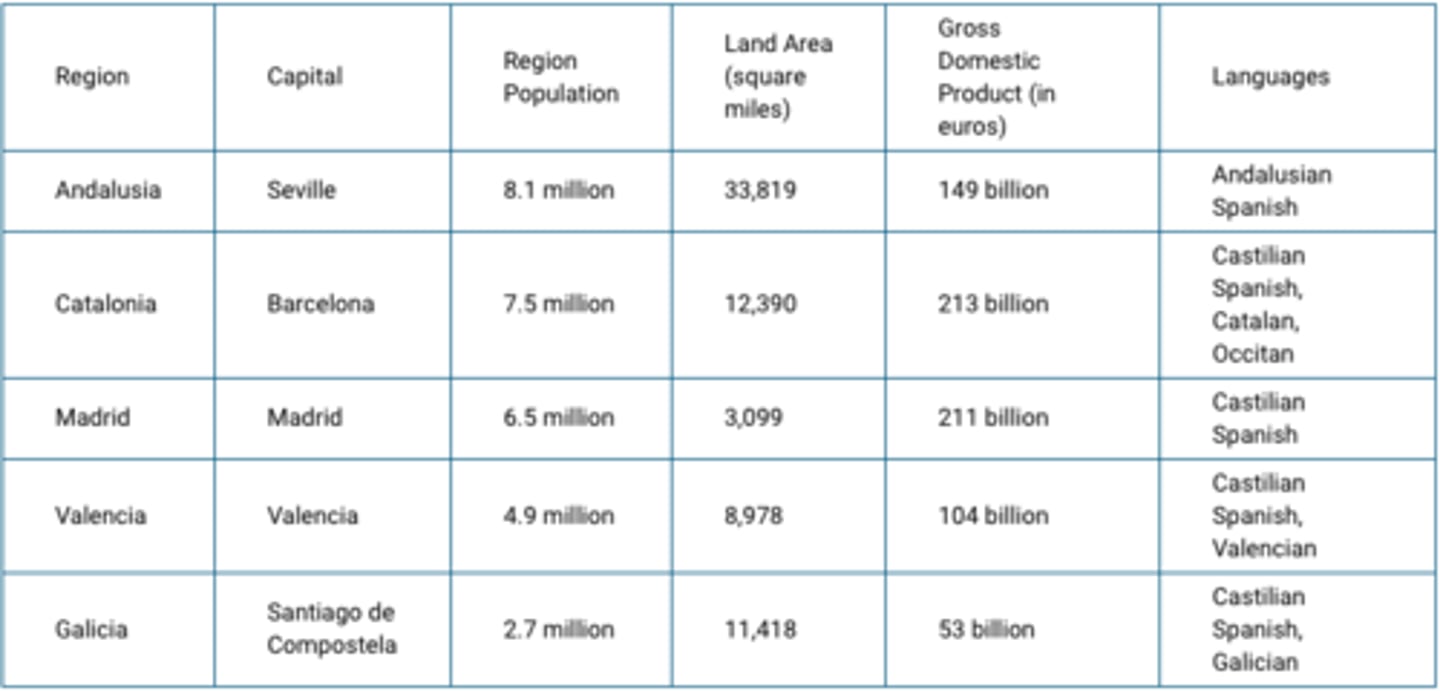
Which of the following best explains why the region of Catalonia in Spain could be a viable country?
a. Catalonia's population is ethnically distinct compared to other regions in Spain.
b. Catalonia is well developed economically compared to other regions in Spain.
c. Catalonia is linguistically distinct compared to other regions in Spain.
d. Catalonia has a major city, Barcelona, which has a notoriety comparable to that of the Spanish capital, Madrid.
e. Catalonia has a large population compared to other regions in Spain.
b. Catalonia is well developed economically compared to other regions in Spain.
The map above shows the countries in Africa where private investors and foreign governments have leased farmland for large-scale commercial farming. Usually much of the food produced is bound for wealthier nations. This practice is an example of
a. decolonization
b. Pan-Africanism
c. neocolonialism
d. imperialism
:e. irredentism
c. neocolonialism
Which of the following correctly lists the usual hierarchy of political-administrative units in order from the largest to the smallest?
a. Empire, nation-state, province, county
b. County, nation-state, province, empire
c. Province, empire, nation-state, county
d. Empire, nation-state, county, province
e. Empire, county, province, nation-state
a. Empire, nation-state, province, county
A good example of a centripetal force in political geography is ___
a. rugged topography
b. a poorly developed road network
c. religious diversity and conflict
d. the existence of different language regions
e. a primate city
e. a primate city
The Berlin Wall fell in 1989, but people in the former East and West Germany still feel its influence. Geographers would say that where the wall once stood now acts as a __
a. fortified boundary
b. antecedent boundary
c. natural boundary
d. relict boundary
e. superimposed boundary
d. relict boundary
Some territories within the Russian Federation are characterized by concentrated populations of ethnic groups and these areas function as autonomous republics. Which of the following best explains the political relationship between the autonomous republics and the central government of Russia?
a. The central government of Russia exerts complete control over the autonomous republics to counteract devolutionary pressures.
b. Russia is a multistate nation characterized by contested regional boundaries
c. The autonomous republics provide ethnic groups with some political control over their homelands while preserving Russia's territorial integrity.
d. The autonomous republics are able to function independently from the central government because of an abundance of natural resources.
e. Russia is a unitary state characterized by many ethnic groups united within a single country.
c. The autonomous republics provide ethnic groups with some political control over their homelands while preserving Russia's territorial integrity.
Which of the following events could be a threat to a state's sovereignty at the national scale, while holding a region together at the global scale?
a. A shift from a federal system to a unitary system of governance within the state
b. Admittance into a supranational organization such as the European Union
c. A member of the state's minority political party being elected to lead the country
d. Decommitment to environmental resolutions established by the United Nations
e. A natural disaster such as an earthquake or tsunami occurring within the country
b. Admittance into a supranational organization such as the European Union
The boundaries of congressional districts of the United States are ___
a. set according to a process developed by the writers of the United States Constitution
b. redrawn every ten years
c. drawn to cross over state boundaries
d. redrawn after every presidential election
e. redrawn whenever a member of Congress feels his or her constituency has changed
b. redrawn every ten years
Which of the following correctly compares the impact of centripetal forces at the local scale with the impact of centripetal forces at the national scale?
a. Centripetal forces may result in nationalism at the local scale but not at the national scale.
b. Centripetal forces at both the local scale and the national scale may lead to increased cultural cohesion.
c. Centripetal forces may cause uneven development at the local scale but not at the national scale.
d. Centripetal forces may lead to stateless nations at the national scale but not the local scale.
e. Centripetal forces at both the local scale and the national scale may lead to failed states.
b. Centripetal forces at both the local scale and the national scale may lead to increased cultural cohesion.
Based on the data in the table, which of the following is a possible impact of ethnic and religious diversity in Iraq?
a. Ethnicity and religion act as centripetal forces in the country by creating a common Iraqi identity among the population.
b. Ethnicity and religion promote economic development in the country by generating national pride in the country's accomplishments.
c. Ethnicity and religion lead to devolutionary pressures in the country by politically dividing regions.
d. Ethnicity and religion increase cultural cohesion in the country by promoting shared political ideology.
e. Ethnicity and religion facilitate democratization in the country by motivating participation in elections.
c. Ethnicity and religion lead to devolutionary pressures in the country by politically dividing regions.
Which of the following describes a federal form of governance?
a. Federal states encourage devolutionary movements and break apart quickly.
b. Multiple substates have local control and are unified to pursue common goals at the national level.
c. Autonomous regions act outside the authority of a central government.
d. A centralized government creates a barrier to local participation in the political process.
e. Laws are enacted in a single language to promote cultural unity.
b. Multiple substates have local control and are unified to pursue common goals at the national level.
Which of the following is the correct organizational scale for the Economic Community of West African States (ECOWAS)?
a. national
b. state
c. supranational
d. local
e. global
c. supranational
Which of the following compares the impact of increased global communications technology to the impact of state-controlled media?
a. Global communications technology is utilized as a centripetal force to present a common message, whereas state-controlled media may bring in new ideas that act as centrifugal forces.
b. Both global communications technology and state-controlled media act as centrifugal forces because they give citizens access to concepts or ideas that may inspire dissent.
c. Both global communication technology and state-controlled media act as centripetal forces that present a common message, which is utilized by the government to bind citizens together.
d. Global communications technology may bring in new ideas that act as centrifugal forces, whereas state-controlled media is utilized as a centripetal force to present a common message.
e. Neither global communications technology nor state-controlled media have any impact on the viability of a state when it comes to centripetal or centrifugal forces.
d. Global communications technology may bring in new ideas that act as centrifugal forces, whereas state-controlled media is utilized as a centripetal force to present a common message.
The Canadian government created the new territory of Nunavut in order to
a. grant autonomy to the Cree and Mohawk people living in eastern Canada
b. guarantee Canadian fishing rights in the Atlantic Ocean
c. recognize the territorial rights of indigenous people in the area
d. facilitate the exploration of mineral resources in the Northwest Territories
e. re-create the pre-1912 boundary of Quebec
c. recognize the territorial rights of indigenous people in the area
Which of the following groups represents a stateless nation?
a. Turks
b. Kurds
c. Albanians
d. Germans
e. Israelis
b. Kurds
In 1982 the United Nations Convention on the Law of the Sea (UNCLOS) established freedom-of-navigation rights and defined territorial waters as a 12-nautical-mile limit from the coast where individual states have political and economic sovereignty. However, Greece and Turkey still only claim a 6-nautical-mile territorial sea.
If Greece and Turkey adopted the UNCLOS system and expanded their territorial seas to 12 nautical miles, as shown in Map 2, which of the following scenarios best explains the resulting geographic pattern?
a. Greece would be required to guarantee the right of passage for ships transiting from the Dardanelles to the Mediterranean Sea.
b. Turkey would be forced to join the European Union in order to participate in international trade and benefit from the open border policy.
c. International ships transiting from the Mediterranean Sea to the Black Sea would only be able to sail in Turkey's coastal waters.
d. Greece would only guarantee right of passage to ships from other European Union countries due to the open border policy.
e. Black Sea countries like Bulgaria would have to ship goods by land through Europe or Russia to participate in international trade.
a. Greece would be required to guarantee the right of passage for ships transiting from the Dardanelles to the Mediterranean Sea.
Which of the following can be an example of a centrifugal political force?
a. Variation of language within the country
b. Shift to tertiary economy
c. Strong central government
d. Homogeneous ethnic population
e. Concentrated ownership of media
a. Variation of language within the country
In the United States House of Representatives there are a fixed number of 435 seats divided among the states based upon each state's relative population size. Changes in the number of representatives, as shown on the map, affect politics at which of the following scales?
a. national
b. state
c. regional
d. county
e. city
a. national
Which of the following is a likely outcome of gerrymandering?
a. Splitting areas of majority group voters across a number of legislative representatives' districts
b. Placing a legislative representative's districts in a row pattern while drawing a new electoral map
c. Disrupting electronic polling machines or the data networks run by elections officials
d. Supporting political party candidates with campaign funds intended to be used in particular geographic areas
e. Packing areas of minority group voters into a single legislative representative's district
e. Packing areas of minority group voters into a single legislative representative's district
Boundaries based on the median-line principle are generally associated with __
a. converging ethnic territories
b. bodies of water
c. major highways
d. mountain ridges
e. unsettled frontier zones
b. bodies of water
Based on the information in the map, what is the most likely outcome of the possible establishment of an independent Kurdistan for the Kurdish people?
a. The Kurdish people, seeking a state of their own with a majority Kurdish population, might secede from or rebel against the states labeled on the map.
b. The state of Turkey, seeking to connect areas with a substantial Kurdish population into an independent state, might take action against neighboring states.
c. The Kurdish people would have to migrate into a single country to gain a population majority and would struggle for control of the government.
d. In areas with a Kurdish majority population, Kurdish people are politically active among Turks, Iranians, Iraqis, and Syrians and would be able to win an election on a national vote to secede.
e. The countries shown on the map will cooperate and work together to address the political situation and needs of people in areas with a substantial Kurdish population.
a. The Kurdish people, seeking a state of their own with a majority Kurdish population, might secede from or rebel against the states labeled on the map.
Which of the following explains why Korea and Vietnam were viewed as shatterbelts during the Cold War?
a. Korea and Vietnam were politically controlled by regional powers.
b. Korea and Vietnam tried to control land and sea areas around their states.
c. Korea and Vietnam experienced conflict due to a dispute between global powers.
d. Korea and Vietnam kept two political adversaries geographically separated.
:e. Korea and Vietnam fragmented into new states due to internal tensions.
c. Korea and Vietnam experienced conflict due to a dispute between global powers.
Which of the following is an example of a superimposed boundary?
a. The geometric boundary between Iraq and Saudi Arabia
b. The Pyrenees Mountains between France and Spain
c. The border of the European Union
d. The geometric boundary between the United States and Canada
e. The Great Wall of China
a. The geometric boundary between Iraq and Saudi Arabia
What is the source of dispute between Canada, Russia, Norway, Denmark, and the United States over political boundaries in the Arctic Ocean and ownership of the North Pole?
a. They all claim the right to extract natural resources out to the edge of the continental shelf, beyond their exclusive economic zones.
b. The North Pole is the focal point of all the intersecting boundaries on the map. However, it floats on a constantly moving ice sheet
c. They all claim to have had indigenous residents from their countries living on the polar ice pack at sometime in the past.
:d. Each claims the first explorer to reach the North Pole came from their country and planted their flag, signifying ownership.
e. The northern polar region has the same international treaties that govern land use and resources in Antarctica.
a. They all claim the right to extract natural resources out to the edge of the continental shelf, beyond their exclusive economic zones.
At some point in their recent history, all of the following countries became divided into two political entities as a result of cultural or ideological conflict EXCEPT
a. Germany
b. Vietnam
c. Japan
d. Ireland
e. Korea
c. Japan
The Philippines and Malaysia lay claim to resources under and around the Spratly Islands. Which of the following best explains how the United Nations Convention on the Law of the Sea (UNCLOS) influences claims to the islands by both countries?
a. The Philippines and Malaysia both claim the islands lie within their contiguous zones between 12 and 24 nautical miles from their coasts.
b. The claims to the islands by the Philippines and Malaysia overlap due to the median line principle.
c. The Philippines and Malaysia both claim the islands lie within their territorial seas up to 12 nautical miles from their coasts.
d. The Philippines and Malaysia both claim ownership to the resources based on a historic possession of the islands.
e. The claims to the Spratly Islands by both the Philippines and Malaysia overlap due to exclusive economic zones up to 200 nautical miles from their coasts.
e. The claims to the Spratly Islands by both the Philippines and Malaysia overlap due to exclusive economic zones up to 200 nautical miles from their coasts.
The Berlin Conference established the borders of North African countries including Egypt, Libya, and Sudan. The landscape of these countries influenced the types of boundaries imposed by the European colonial powers. Which of the following boundary types best explains the influence of landscape on the political borders of the North African region?
a. Subsequent, with smaller buffer states placed between larger states to prevent political conflicts
b. Antecedent, based on tribal cultural boundaries that existed before European colonization
c. Geometric, with straight lines, disregarding physical features or tribal cultural differences of the areas
d. Consequent, accounting for local differences in language and religion during European colonization
e. Natural, with irregular lines, accounting for regional physical features such as mountains or water bodies
c. Geometric, with straight lines, disregarding physical features or tribal cultural differences of the areas
Crossing which of the following borders requires few, if any, formalities and thus encourages the free flow of people and products?
a. Romania-Ukraine
b. Netherlands-Belgium
c. United States-Canada
d. India-Pakistan
e. North Korea-South Korea
b. Netherlands-Belgium