2A Glaciated Landscapes and Change
1/169
Earn XP
Description and Tags
Name | Mastery | Learn | Test | Matching | Spaced | Call with Kai | Chat |
|---|
No analytics yet
Send a link to your students to track their progress
170 Terms
Era
Hundreds of millions of years in duration. Examples include the Mesozoic, the end of which is defined by the extinction of the dinosaurs, and the Caenozoic, which is the current era and began roughly 65 million years ago.
Climate change’s impacts on tourism in alpine tundra
Swiss Alps Impacts
Continuously retreating glaciers might threaten glacial lake outburst floods causing dangerous flooding and mudslides
Possible closure of ski resorts at lower altitudes as research suggests that by 2050 only those resorts higher than 1500m will be able to offer skiing
5% of Switzerland is covered by permafrost
Increased melting of permafrost threatens rock avalanching and mudslides
several mountain settlements are under threat and ski lifts
Research suggests that a rise in temperature of 2 degrees Celsius will cost Switzerland about £2 billion year because of the impacts on winter tourism and measure needed to deal with the increase in flooding and other natural disasters caused by rising temperatures
Climate change’s impacts on water in alpine tundra
Alpine rivers transport an average of 215km3 of water a year to nearby regions
In the summer months much of Europe’s water comes from melting Alpine glaciers
In less than 100 years, the Eastern Alps predicted to be completely ice free
Precipitation in the form of snow would diminish
Potential impact on water quality
Protecting and conserving the Alps
The Alpine Convention – an international treaty between members of the EU and Alpine countries working together to protect the natural environment and promote its economic development
More than 20% of the Alps consists of national parks and protected areas which have a range of biodiversity
Baffin Island: A periglacial landscape
NW Canada
Tundra ecosystem - Arctic Tundra.
Glaciated 120,000 years ago
Summer sun exposure leads to melting of permafrost so east side of island open to tourism
Permafrost covers covers access to waterways year-round in the west
Continuous permafrost, a number of ice caps including Penny and Barnes ice caps.
Some rugged mountains some flat lowlands.
Coastal strip is littered with lakes and ponds fed by run-off streams.
Long dark and cold winters, but in short summer the active layer of soil melts, creating a vast network of lakes, streams, rivers, and wetlands.
The waterlogged soil and 24 hour sunshine in the summer boosts rapid plant growth of densely packed low-lying plants growing in lower tundra latitudes
Sagarmatha National Park - facts and management
UNESCO World Heritage site since 1979
Glaciers retreating 13% in 50 years
2015: 7.8 mag earthquake hit Everest South Base Camp killing 22 people incl 10 sherpa
Players:
National park and wildlife conservation office - NP was established in 1976 and a buffer zone was added in 2002 to enhance protection
Sherpa people - 6000 live in the area
Other residents who have set up businesses, eg guest houses and holiday companies
Park Advisory Committee incl local leaders, head lamas
NGOs - Sagarmatha Pollution Control Committee involved in pollution control and rubbish disposal
Global community - UNESCO
Aims and strategies:
use kerosene for cooking and heating rather than wood to reduce deforestation
Banning goats as they destroy vegetation and biodiversity
Limiting development projects - Lukla Airport for Everest Base Camp only 530m runway with 12% gradient, 2.8km in the air, 71,000 passengers in 2003, 150,000 in 2017, also extension to Syangboche airport
establishing plant nurseries to provide seedlings to reestablish forests - reduce erosion
setting up projects sponsored through Sir Edmund Hillary Foundation incl building schools, hospitals, bridges
building micro HEP stations to generate electricity for local and domestic use
Threats to Sagarmatha
Glaciers are retreating, 13% in 50 years
when a glacier melts, formation of pro glacial lakes is encouraged. moraine wall containing glacial lake may collapse, causing a GOF or jokulhlaup
consequences for HEP generation downstream
August 1985, one GOF caused a 10-15m high surge of water and debris to flood down the Bhote Koshi and Dudh Koshi rivers in Nepal, destroying Namche Small Hydro Project
Other GOFs have led to the deaths of at least 900 people across high mountain asia
Avalanches
Farming and deforestation for building clears natural vegetation
Forests stabilise snow so fewer trees = more chance of avalanche
Deforestation
Loss of habitats; red panda, snow leopard, Himalayan tahr, 100 species of bird
Erosion of exposed soil, nutrients are washed away lowering fertility decreases biodiversity
Increased risk of landslides
Disruption to water cycle
Tourism in Sagarmatha
Threats
Water pollution
Footpath erosion
Problems with waste disposal
Construction of illegal trails
Why more climbers?
Chances of a successful summit increased
Better weather forecasting
Problems
Two main routes have become dangerously crowded and polluted
Solutions
Limiting number of climbing permits issued per year
Restricting group sizes
Insisting all guides are properly qualified
Present day distribution of high lat ice sheets and evidence for Pleistocene ice sheet extent
Cryosphere is all frozen regions on Earth, 13% of Earth's surface. Ice found more than 65º north and south. 85% of cryosphere is in Antarctica and 12% in Arctic, as ice sheets, shelf ice, and permafrost. Antarctic ice sheet covers 8.3% of global land surface, up to 5km deep, covers 14 million km
Gulkana Glacier
Jakobshavn Glacier
20m per day at its most
Periglacial landscapes
Wide expanses of featureless plains
Low lying marshy vegetation (due to waterlogged active layer)
Streams and rivers common in summer
Tundra vegetation; low growing plants, lichens, mosses, grasses, dwarf shrubs
Waxy leaves to reduce water loss to high winds
Short summer so quick plant reproduction
Geomorphological processes in periglacial regions
Open Pingo formation
Water freezes in upper layer of soil where permafrost is thin or discontinous, leading to the expansion of ice in the soil
Overlying sediments heave upwards into a dome-shaped feature less than 50 m high , up to 500m across
Mainly found on sandy soils
Open pingo or East Greenland type
Closed Pingo formation
Typical of low-lying areas with continuous permafrost
On the site of small lakes, groundwater can be trapped by freezing from above and by the permafrost below as it moves inwards from the lakeside
Subsequent freexing and expansion of the trapped water pushes the overlying sediments upwards into a pingo form
If the centre of the pingo then collapses, it may infill with water to form a small lake.
Over a thousand of this type of pingo have been recorded on the Mackenzie Delta in Canada
K-T Extinction
The Cretaceous-Paleogene (Cretaceous-Tertiary) Extinction was a sudden mass extinction event, 66 million years ago, which saw ¾ of the flora and fauna species on Earth go extinct. It is attributed to an asteroid that impacted the Yucatán Crater.
Period
The length of time below eras, spanning tens of millions of years. Examples include the Tertiary, which began with the Caenozoic, and the Quaternary, which began 2.6 million years ago, and has seen the evolution of humans (Homo sapiens first on Earth around 200,000 years ago).
Epoch
The smallest unit of geographical time. Epochs last several million years. Examples include the glacial Pleistocene, which began 2.6 million years ago, and lasted until around 12,000 years ago, and the Holocene, the current epoch, which is also an interglacial.
Pleistocene
The glacial epoch that began 2.6 million years ago, and ended around 11,700 years ago. During the Pleistocene peak periods, global average temperatures were between 5 and 10ºC, although this fluctuated from season to season and through (inter)stadials, of which there were 20 cycles. Furthermore, the maximum extent of Pleistocene glaciation saw 1/3 of land surface covered, namely North America, Northern and Eastern Europe, parts of Russia, and Antartica.
Frequency of significant glacials.
Roughly every 200-250 million years there is a significant glacial period. Cycles of climatic change (stadials) still occur between and within these periods, but do not affect the Earth for long periods afterwards, unlike glacials.
Greenland Past
During last glacial maximum, GIS held an extra 4.1m of ice in sea level equivalent, and is the only remaining ice sheet from this tiem
Data suggests that in past interglacials there was significantly less ice than there is today
Greenland Present
Data shows massive loss of ice over recent decades, mainly due to increased air and ocean temperatures
Iceberg calving, meltwater runoff, ocean-driven melting have all increased and contributed to a negative surface mass balance
Greenland’s melt season has dropped well below the 1981-2020 average, resulting in a sea level rise of 0.7mm per year, which is greater than the whole Antarctic contribution
Continued melting of Greenland could contribute 5 to 33cm to sea level by 2100
If the ice sheet melted completely, there could be up to 7.4m of sea level rise around the globe
London and New York are only 11m above sea level on average
This much rise could flood Pimlico, Chelsea, Southwark
Greenland Future
Continued global warming will increase the rate of ice sheet melting as a positive feedback mechanism
Exposed ground reduces the albedo effect on the surface, increasing ground warming and further snowmelt
Increased melting leads to the release of stored carbon and methane into the atmosphere, amplifying the greenhouse effect and increasing warming
The height of Greenland would initially be lower as surface ice melts, however with the release of weight, the isostatic rebound would eventually counteract this and Greenland would rise
Large amounts of freshwater melting into the ocean could affect thermohaline circulation and cut off the Gulf Stream (the current that keeps the UK inhabitable)
Uncertainty over mining in Greenland, Trump threatening to buy/invade the country
2014 Government decision to allow Uranium mining could endanger fisheries and farmland
Future Arctic sea ice melt (by 2050) will open new trade routes across the North Pole making Greenland strategically significant
Current glacial extent
Around 10% of land is covered by glaciers or permanent ice today, and this is fast decreasing. Sea ice today has also retreated significantly since the Pleistocene, especially in the Antarctic Circle and Greenland. Since the Pleistocene, all North American ice cover has disappeared, apart from Greenland, whos extent has still decreased. Some ice cover still exists locally in previously glaciated regions, such as the Alps, the Pyrenées, and Siberia. Alpine cover has mostly disappeared, while continental (polar) cover has retreated noticabley.
Pleistocene megafauna
By around 13,000 years ago, ¾ of Ice Age megafauna had died out. This included woolly mammoths (which had walked the planet for roughly 250,000 years), elks, and more. This may have been due to human overhunting, as by the end of the Pleistocene, modern humans were found all over the globe. However, the changing climate must have also played a large role in the disappearance of the megafauna, as humans alone were not sufficient enough to cause mass extinction.
Devensian epoch
115,000 to 11,700 years ago. Also known as the Last Ice Age, or the Last Glacial Period. Simply, it was a cold (glacial) period which saw glacial advance, and terminated with the beginning of the Holocene, an interglacial.
Quarternary Ice Age
Most recent ice age that started 2.6 million years ago with two epochs (Pleistocene and Holocene). It is considered an ice age because at least one permanent ice sheet (the Antarctic) has existed continuously.
Loch Lomond Stadial
Last glacial advance in the UK 12,000-10,000 years ago, during the Devensian period. It is evidenced by ice caps developing in the Scottish Highlands, and we can look at ice cores and tree rings to get an idea of the climate during that period.
Little Ice Age
Between 1300-1870 when average temperatures were 1-2C cooler, resulting in glaciers re-advancing and abandoned settlements in Iceland. Europe saw famines and poor harvests, which led to population decline. Trade and communication decreased significantly as rivers and coastal seas froze, unideal for a world dependent on oceans in order to travel. However, conditions varied in different places.
Evidence for the Little Ice Age
There were winter festivals with ice skating on frozen rivers and canals in Britain and the Netherlands. Temperatures must have been significantly lower than normal for freezing of large water bodies to freeze. Farms and villages in the Swiss Alps
Climate forcing
Any mechanism that alters the global energy balance and forces the climate to change in response.
Milankovitch Cycles
According to their discoverer, the changes affect the amount of solar radiation that reaches the Earth. These changes are significant enough to start or end an ice age.
Eccentricity Cycle (Milankovitch)
Change in Earth's orbit from circular to elliptical every 100,000 years. Eccentricity is a long term climate event, causing glacial periods when orbit is circular, and interglacials when the orbit is more elliptical.
Obliquity Cycle (Milankovitch)
Tilt of Earth's axis varies from 21.5 to 24.5 over 41,000 years, changing season severity. When tilt increases, summers are warmer and winters cooler, favouring interglacial periods.
Procession of the Equinoxes (Milankovitch)
Earth's wobble on its axis which causes the season in which the the Earth is closest to the Sun to change every 21,000 years
Albedo Effect
The reflection of solar energy from Earth. White surfaces, i.e. snow in polar and alpine regions, reflects more light/heat energy, thus keeping the Earth cooler. However, as the climate warms, more snow and ice melts. This exposes the darker bedrock below glaciers, which absorb more solar energy, and cause further heating of the Earth. This is a positive feedback loop.
Variations in solar output
Flares or sunspots on the Earth’s surface indicate that the sun is emitting more radiation than usual. High sunspot levels mean more heat radiated from the sun, increasing the Earth’s average temperature. Temperature changes by sunspots are usually small (±0.5º), but there can be longer periods than normal, such as the Maunder Minimum from 1650-1700, which is believed to have caused the Little Ice Age.
Thermohaline Circulation
Ocean current circulation that is driven by differences in temperature and salinity
Volcanic eruptions
Large and explosive eruptions can change the Earth’s climate. Eruptions produce ash and sulphur dioxide gas, which can rise into the atmosphere. If they rise high enough (10-50km above the Earth’s surface), they can be spread around by high-level winds, in the stratosphere. The blanket of ash and gas will reflect solar energy back into space, preventing it from reaching the Earth’s surface. The Earth’s surface temperature will fall, and the planet will cool.
Long-term causes of climate change
Plate tectonics (mountain building = more snow) and Panama Isthmus closure caused the Gulf Stream that increased snowfall in the Arctic
Cryosphere
Cold environment where water is in it's solid ice form as snow, icebergs, lake and river ice. 11% of ice in Greenland and 86% Antarctica.
Polar Environment
High latitude, very cold and low precipitation. Slow moving glaciers.
Alpine Environment
High altitude, high precipitation, varied temperature and rapid glaciers
Relict Landscape
No longer experiences glacial activity but contains fossil glacial landforms
Cirque or Corrie
Armchair-like hollow 0.5-10km2 (Cirque Au Mandit)
-Abrasion (at bottom)
-Plucking (at slope)
-Freeze-thaw (at top)
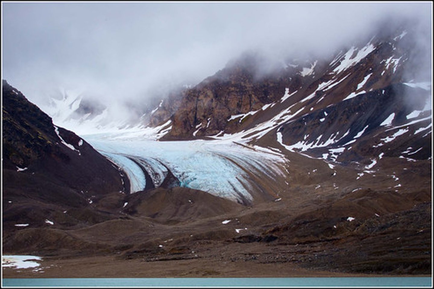
Valley Glacier
Similar to river that flows down valleys covering 10s-1000skm2 (Mer de Glace)
Piedmont Glacier
Glacier that spreads over 10km wide when it reaches an open plain (Wye)
Highland Ice Field
Smaller than an ice cap that is confined by the topography (Vallee Blanche)
Ice Cap
Area of Ice not confined by topography covering up to 50,000km2 (Vatnajokull)
Ice Sheet
Larger than an ice cap, over 50,000km² (Greenland- 1.7 million km²)
Permafrost
Soil, sediment or rock below the ground remains frozen (below 0ºC) for more than 2 years
Up to 500m, even up to 1500m deep
Sporadic is from 0 to -1.5ºC
Continuous is from -1.5 to -50ºC
Talik
Permanently unfrozen ground in a permafrost region
Active layer
Thin layer of unfrozen topsoil that thaws in the summer and freezes in the autumn. Drainage prevented by permafrost as its impermeable, so active layer often becomes waterlogged leading to solifluction.
Freeze-thaw weathering
Water that freezes and expands in cracks in rocks, weakening the rock and causing disintegration
Solifluction
Downslope movement of the active layer in the warmer summer, as it’s saturated with water (Eagle Summit Alaska, even seen on Mars)
Frost heave
Freeze and expansion of water in ground upwells rocks to the surface
Nivation
Freeze-thaw, solifluction and meltwater erosion weakens and erodes the ground beneath a snow patch
Meltwater erosion
Erosion of stream or river channels
Scree
Accumulation of frost-shattered rocks on a slope (Wastwater Lake District)
Ice-Wedge Polygons
Caused from ground contraction from active layer refreezing (Romford)
Patterned ground
Caused from frost heave and creep that causes domes and stones to settle on the edges (Tinto Hill, Scotland)
Ho
Ice lens breaks surface (open) or causes hump under permafrost (Letton, Herefordshire)
Blockside
Block of soil slides from hill leaving dip (Felsenmeer)
Tors
Solifluction exposes solid rock outcrop (Hay Tor)
Solifluction terrace
Terrace of head at the foot of a slope (Edale Valley)
Asymmetrical Valleys
Sloping on one side and steep on opposite side from sunlight increasing solifluction rate on south-facing side (Chilterns)
Dry Valleys
Areas where rivers once flowed when permafrost made the bedrock impervious. Rivers now flow underground due to permeable rock (Devils Dyke, South Downs)
Loess Plain
A lack of vegetation and a big supply of fine, loose material in glacial and periglacial environments enables strong, cold winds (aeolian action) to pick up large amounts of material and redeposit it far away from its source as loess. Covers large areas in the Mississippi-Missouri valley in the USA, as well as in north-west China where there are loess over 300m deep
Braided Channels
A river with multiple channels and non/vegetated sand and gravel banks between channels (Mackenzie Delta, Canada)
Nivation Hollows
Enlarged hollows from nivation (Coire Domhain, Cairngorms)
Thermokarst
Limestone-like scenery thats uneven and pockmarked due to low temperatures
Mass Balance
Difference between total accumulation and ablation in one year (can be positive, negative or zero)
Dynamic Equilibrium
Glacial System will constantly re-balance itself until point of zero mass balance is reached
Positive feedback
Increases the effects of new inputs into a system. E.g glacier grows, increased Albedo effect reflecting radiation, allows continued growth
Negative feedback
Minimise inputs to a system. E.g glacier snout advances, more ice in ablation zone and thus more melting back to equilibrium
Glacier System
accumulation = snow, aeolian action, avalanche
ablation = melting, calving, sublimation
Temperate Glacial Movement
Reach pressure melting point producing meltwater that increases movement (basal slip)
Polar Glacial Movement
Too cold - only can move by internal deformation
Ice Creep
Form of internal deformation; if ice is over 100m thick, ice crystals deform from shear stress
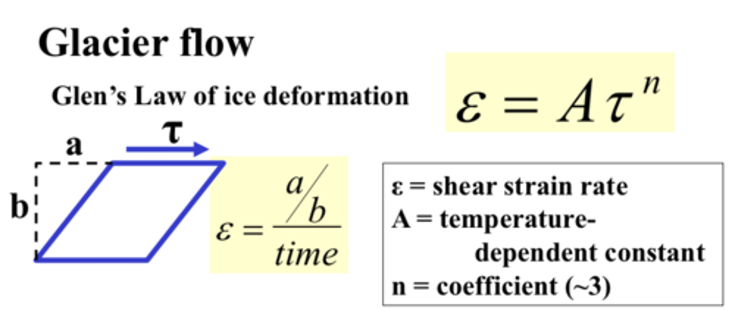
Ice Fracture
Form of internal deformation; sometimes ice creep causes fractures called crevasses that increases ice velocity
Regelation Slip
Form of basal slip; large bedrock under ice increases pressure (melting) and refreezes when pressure lowers, increasing ice movement
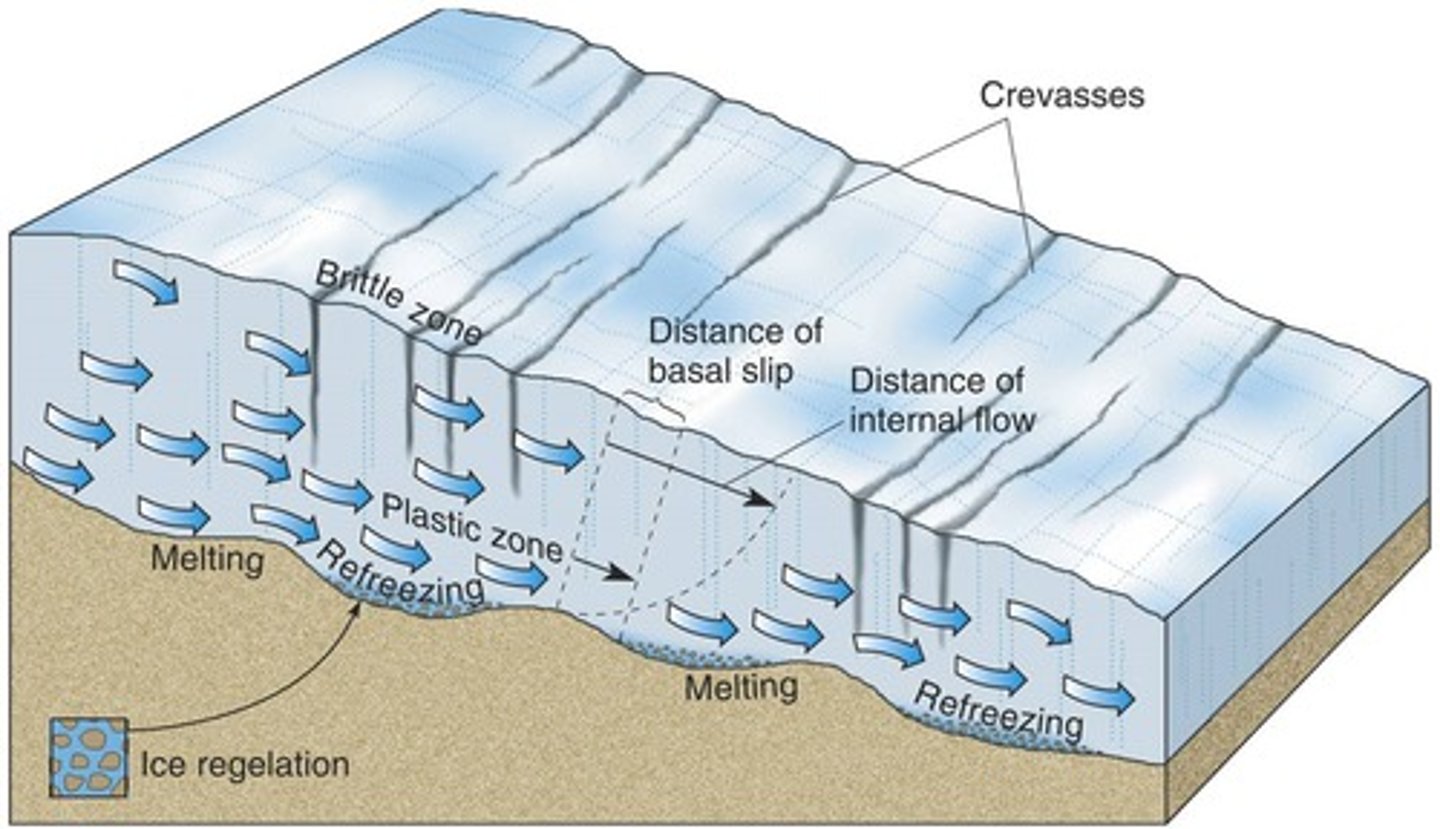
Surges
Form of basal slip; short, fast glacier advance mostly caused by basal sliding
Extending/Compressing flow
Form of basal slip; over steep slopes, basal slip will increase and thin (extending) or over shallower slopes, basal slip slows and ice decelerates and thickens (compressing)
Factors involved in glacier movement
Altitude, slope, lithology, size and variation of mass balance
Glacial crushing
Erosional process that fractures the bedrock due to immense weight that exploits weaknesses from freeze-thaw and pressure release
Abrasion
Erosional process where rock debris at glacier base is dragged, grinding and polishing the bedrock
Plucking
Erosional process in which ice advances downstream over an obstable and plucks loose rocks out of the obstable
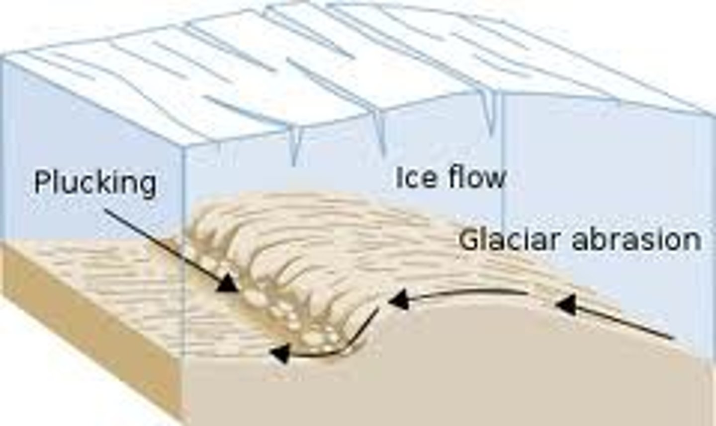
Fluvio-glacial erosion
Streams inside the ice (en/subglacial) are highly erosive from dissolved CO2, abrasive load and high pressure
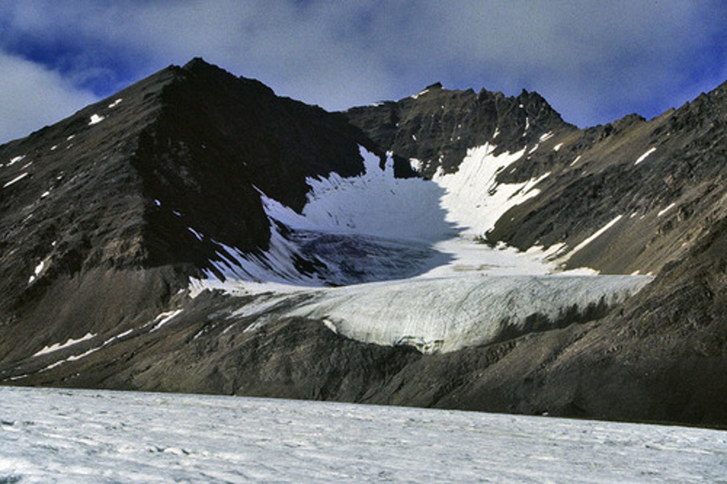
Cirques
Deepened hollow from plucking and abrasion (Cwm Cau)
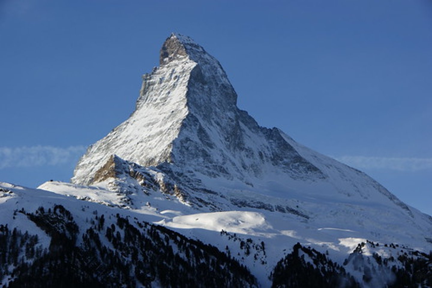
Pyramidal Peak
Sharp, pointed mountain peak with three or more cirques - plucking is important (Matterhorn)
-Plucking
-Abrasion
-Freeze-thaw
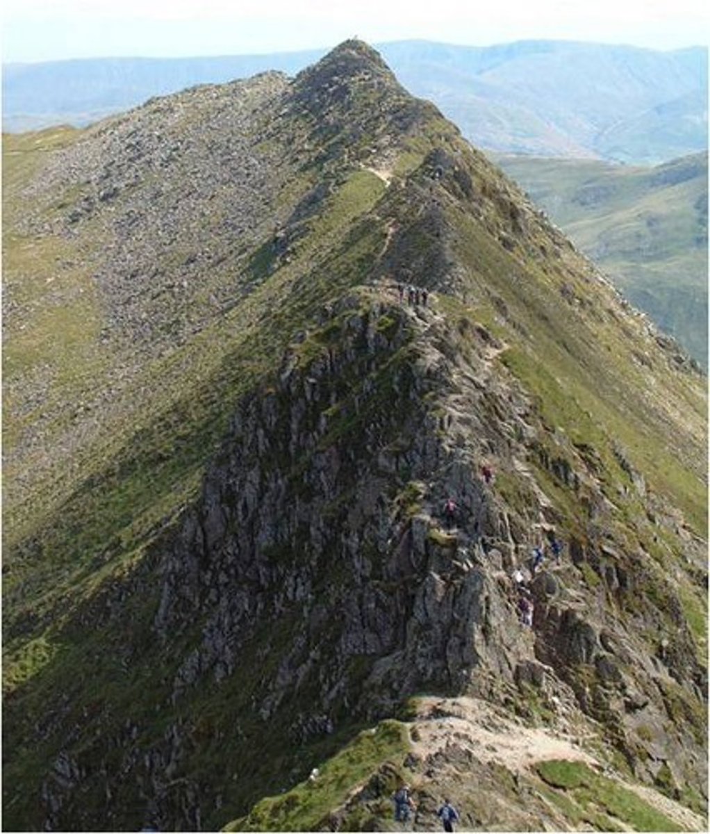
Aretes
Narrow ridge between two cirques (Grib Goch)
-Abrasion
-Freeze-thaw
Glacial Trough
U-shaped valley with steep sides and a wide floor formed by plucking and abrasion (Llanberis Pass)
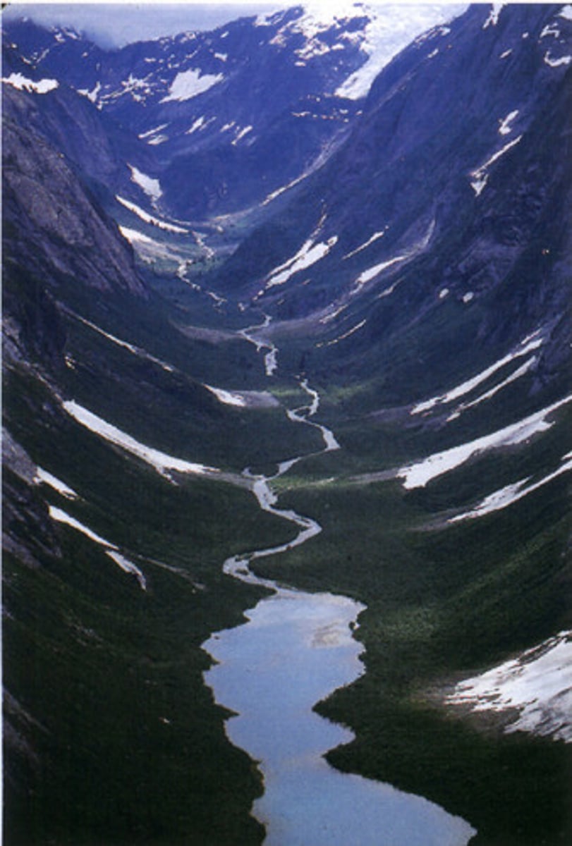
Ribbon Lake
Long, narrow lake along the floor of a glacial trough due to an overdeepened valley (Lake Annecy)
-Abrasion (fast erosion when hit middle soft rock = hollow)
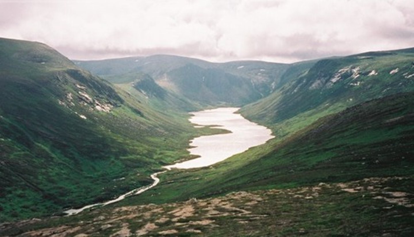
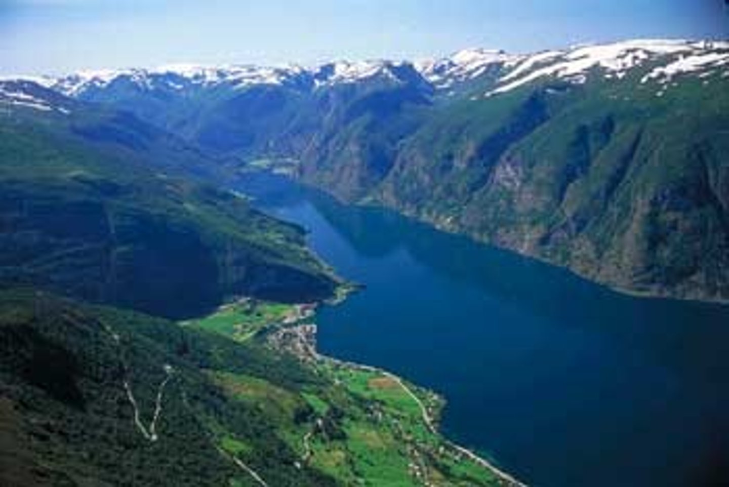
Fjord
Glacial troughs flooded by the ocean (Sognefjord)
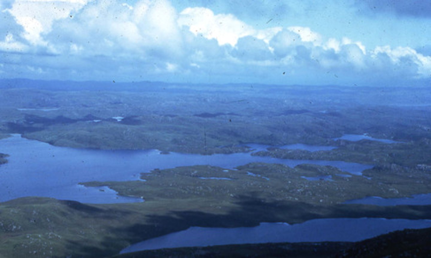
Knock and Lochan
Lowland area with small rock hills (Knock) and hollows that normally form lakes (Lochan) due to Glacial scouring (South Harris, Scotland)
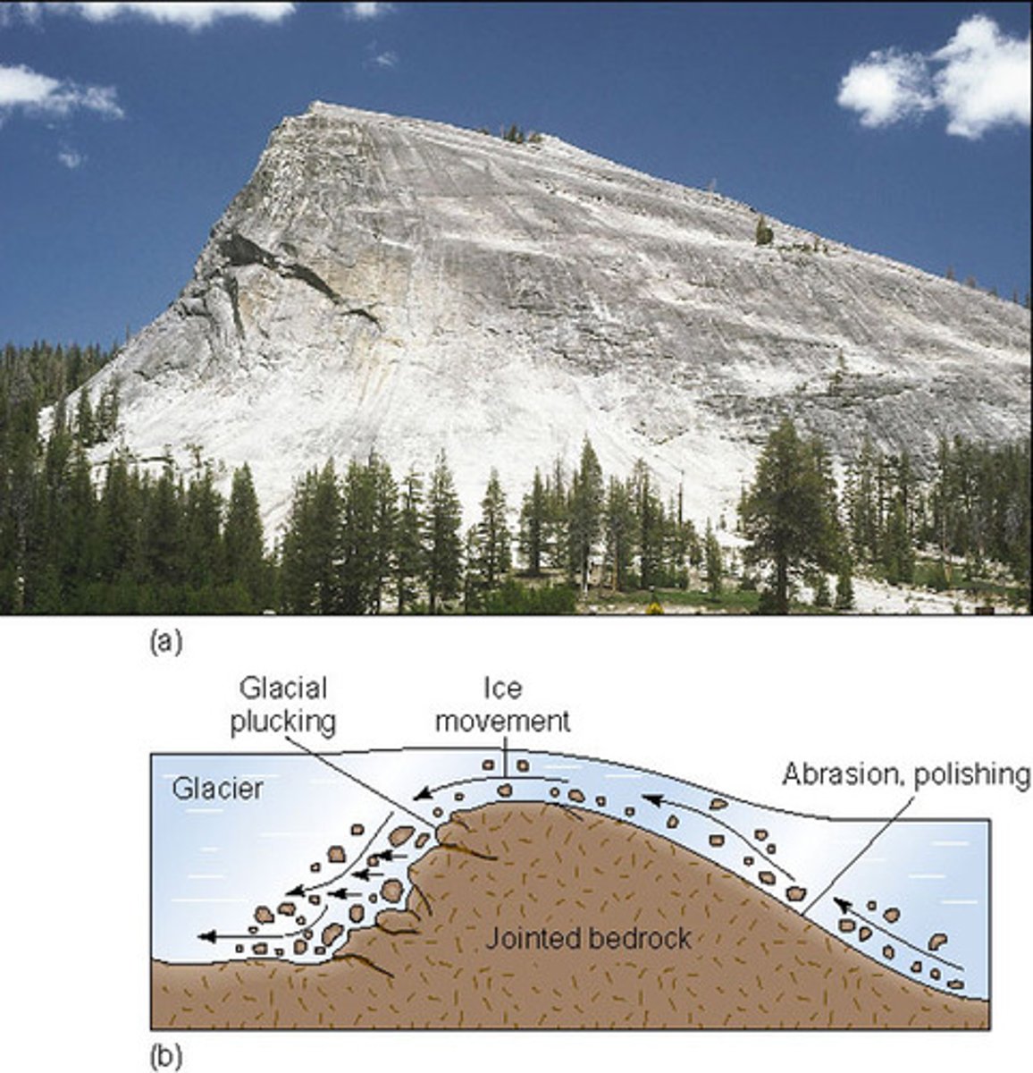
Roche Moutonnée
Bare rock on valley floor with smooth stoss and jagged lee formed from plucking (Grand Balcony trail). The upstream (up-glacier) side is abraded by the increased pressure of the glacier moving over the top, resulting in a polished surface with striations. On the lee side, pressure is reduced, causing localised refreezing of meltwater, which clings to rocks and plucks them off the steep slope as the glacier moves away. This results in a jagged, shorter lee slope.
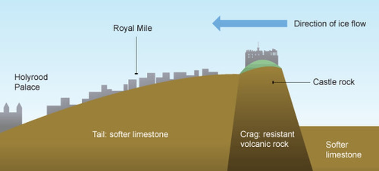
Crag and Tail
Large mass of hard rock forms steep stoss with gently sloping tail of deposited material (Edinburgh castle)
-Abrasion of both ends
-Plucking of steep top
Lateral Moraine
Ice contact landform; till deposited on valley sides (South-side of Wye Glacier)
-Sediment comes from plucking or freeze-thaw
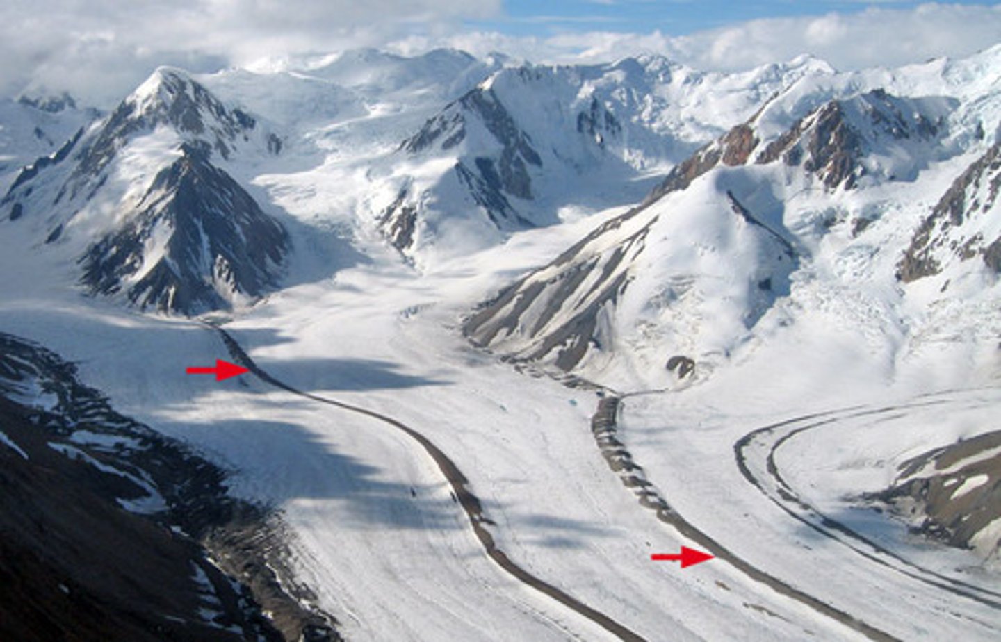
Medial Moraine
Ice contact landform; till deposited in middle of valley parallel to valley sides (Gorner Glacier, Switzerland)
-Sediment comes from plucking or freeze-thaw
Terminal Moraine
Ice contact landform; high ridge of till across a valley at glaciers snout (Briksdalbreen, Norway)
-Sediment comes from plucking or freeze-thaw
-Shows extent of glacier as furthest point is where glacier reached (and shows direction)