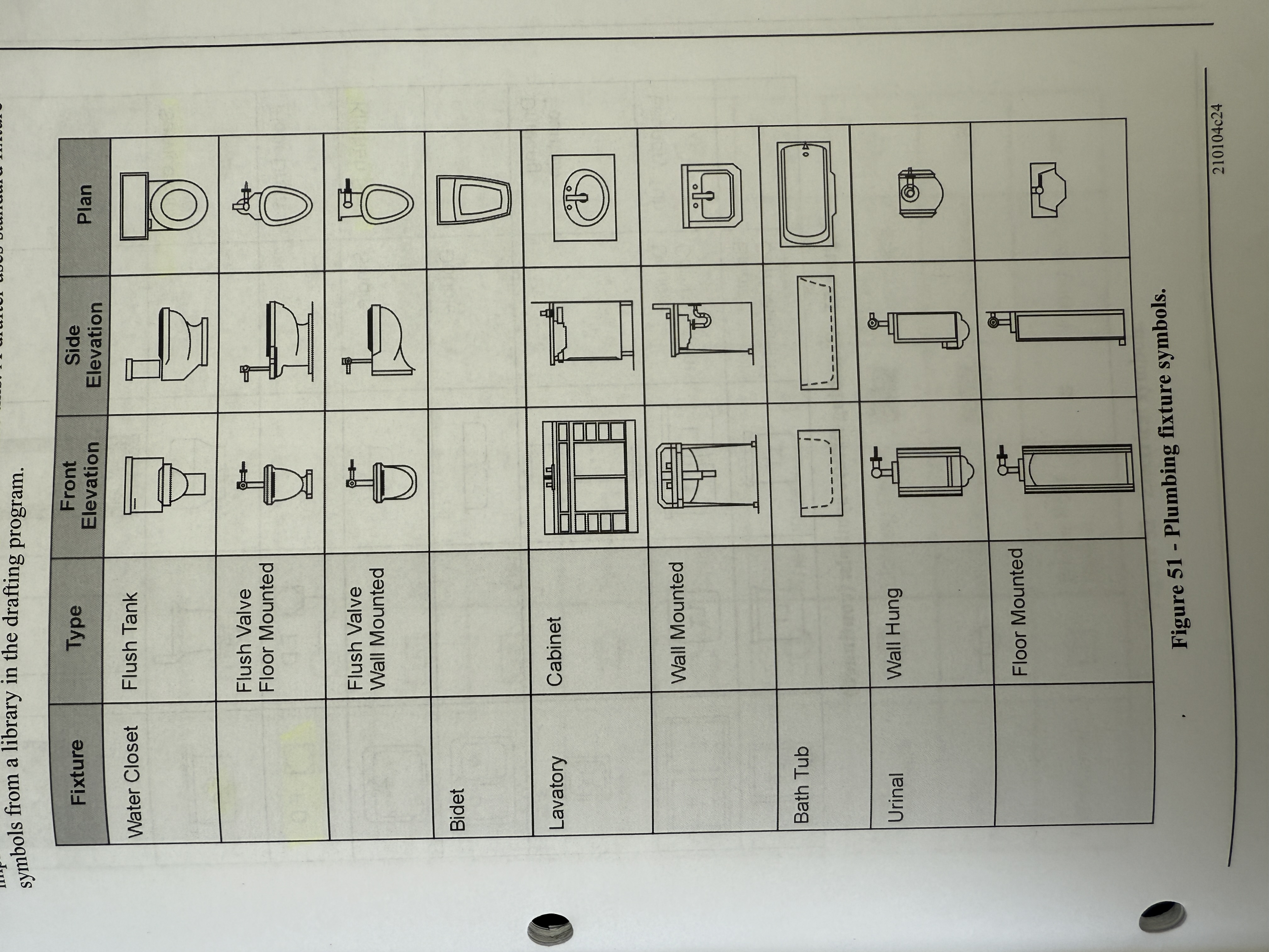
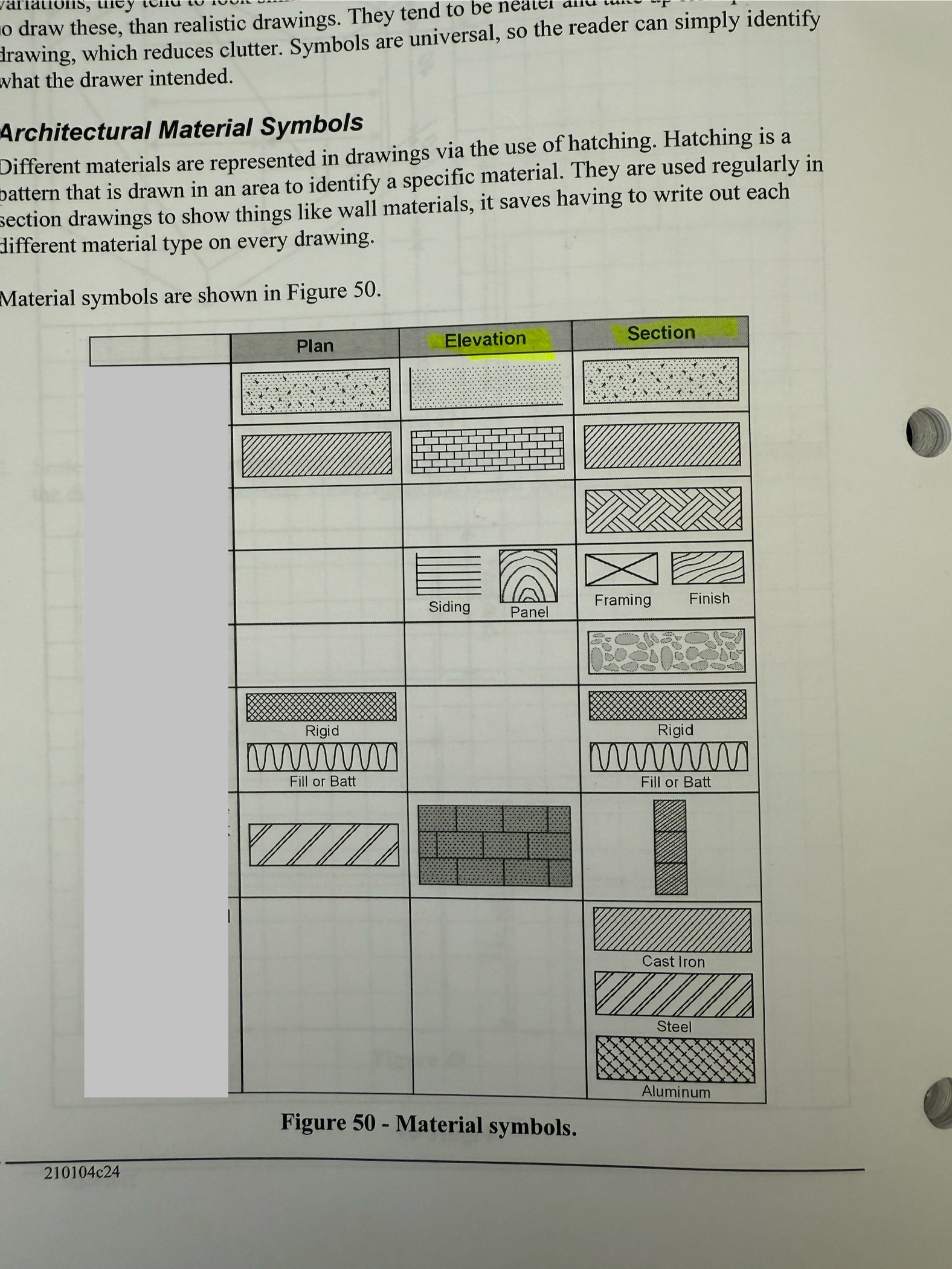
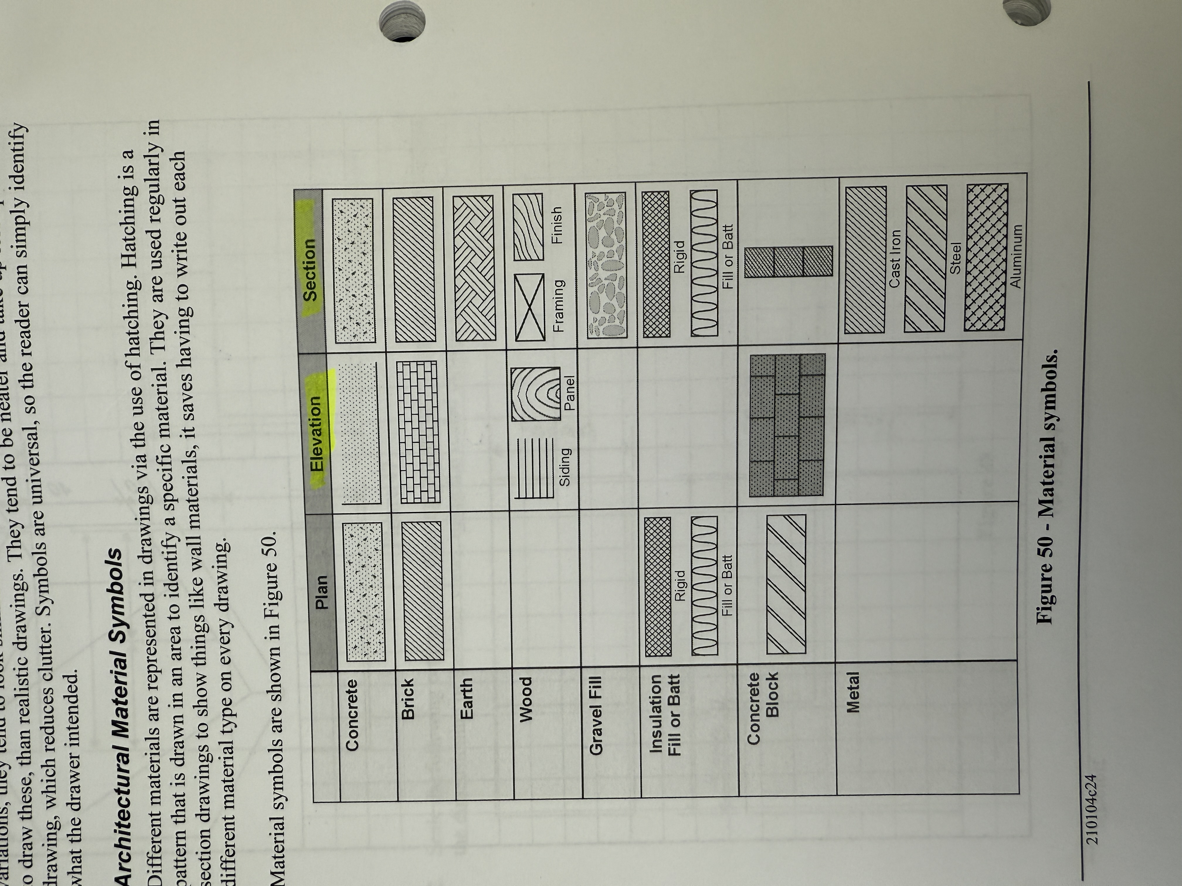
Drawing Interpretation
1/49
There's no tags or description
Looks like no tags are added yet.
Name | Mastery | Learn | Test | Matching | Spaced | Call with Kai |
|---|
No analytics yet
Send a link to your students to track their progress
50 Terms
What does the specification serve as in construction documents?
Standards for selecting materials; if there's a discrepancy between specification and drawing, specification takes precedence.
What is the blueprint order for housing?
Site plan → floor plan → elevation plan → sections and detail drawings.
What is the legal description LSD 13-10-1-1-W4?
It describes a 10-acre parcel in the NW of legal subdivision 13
, section 10,
township 1,
range 1,
west of the fourth meridian.
What is the system used by alberta called for surveying?
“Third System or Township Surveys”
How do contour lines indicate slope steepness?
Contour lines get closer together to indicate steeper slopes.
What does a scale of 1/4” represent in Imperial measurement?
Every 1/4” on the drawing equals one foot in reality.
What do Elevation Views Show
4 sides of a building to indicate the elevation.
How can you use your tape measure for scaling?
using a tape measure: to obtain req’d measurement, measure your line with a tape and divide by scale (for example 1/4in/ft).
if you use metric, measure in mm and multiply it by the scale. 43mm in a 1:50, would be 2150 mm on the job.
How are Buildings Dimensioned?
Buildings are usually dimensioned from outside wall to the :
edge
or center
or openings or interior of walls
How are Interior Dimensions measured?
Interior dimensions are usually from centre of partition or to the face of the wall
How are orthographic and isometric dimensions given?
center to center (most common) or center to face
List the 5 divisions of a drawing package and explain their purpose.
Architectural - Designated by letter A followed by #
building site plan- address/legal description, overhead view of building site, building orientation, utility orientation, drawing scale, geodetic elevations
foundation plan - footings, piles, grade beams, underground piping/utility
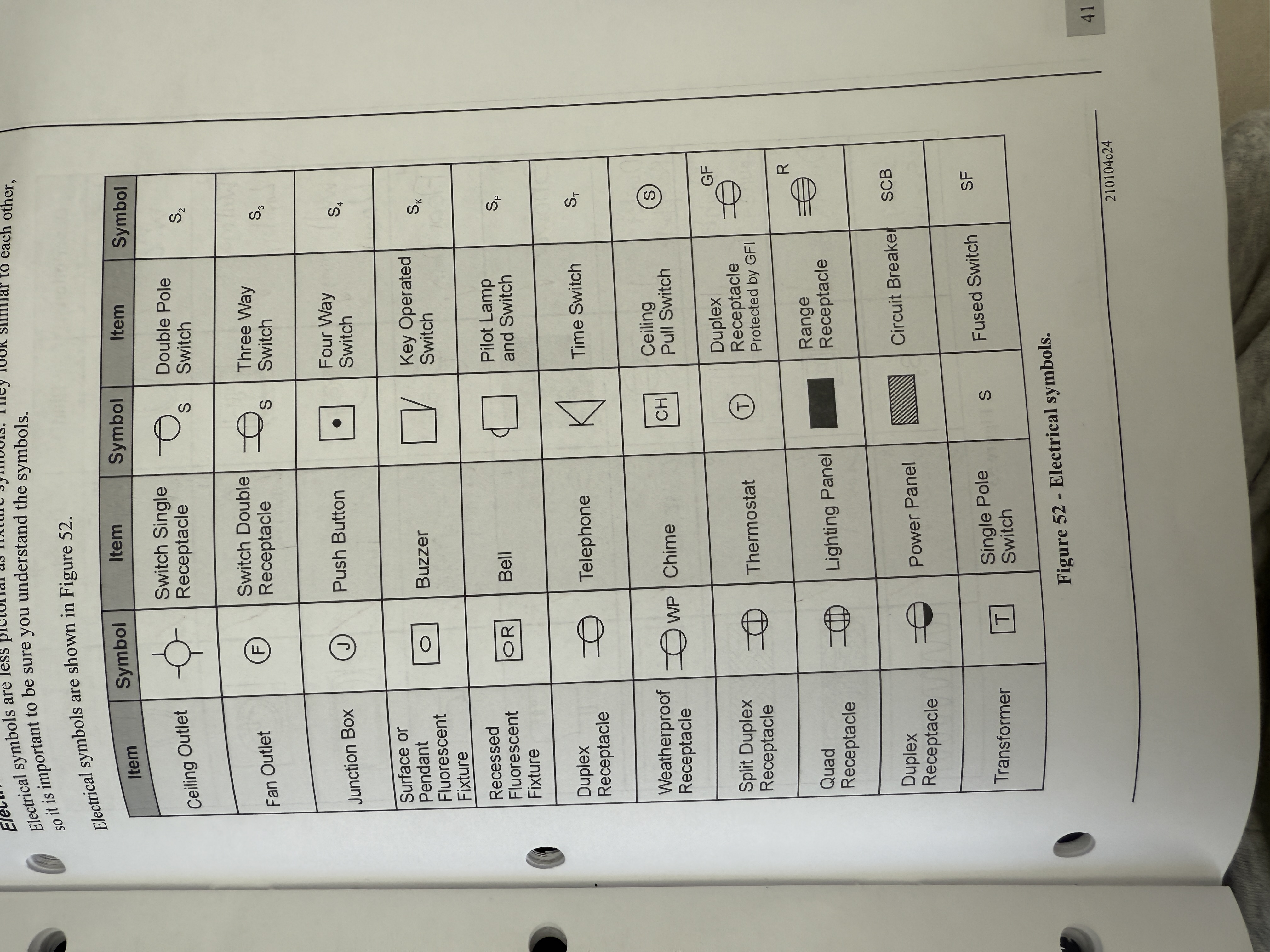
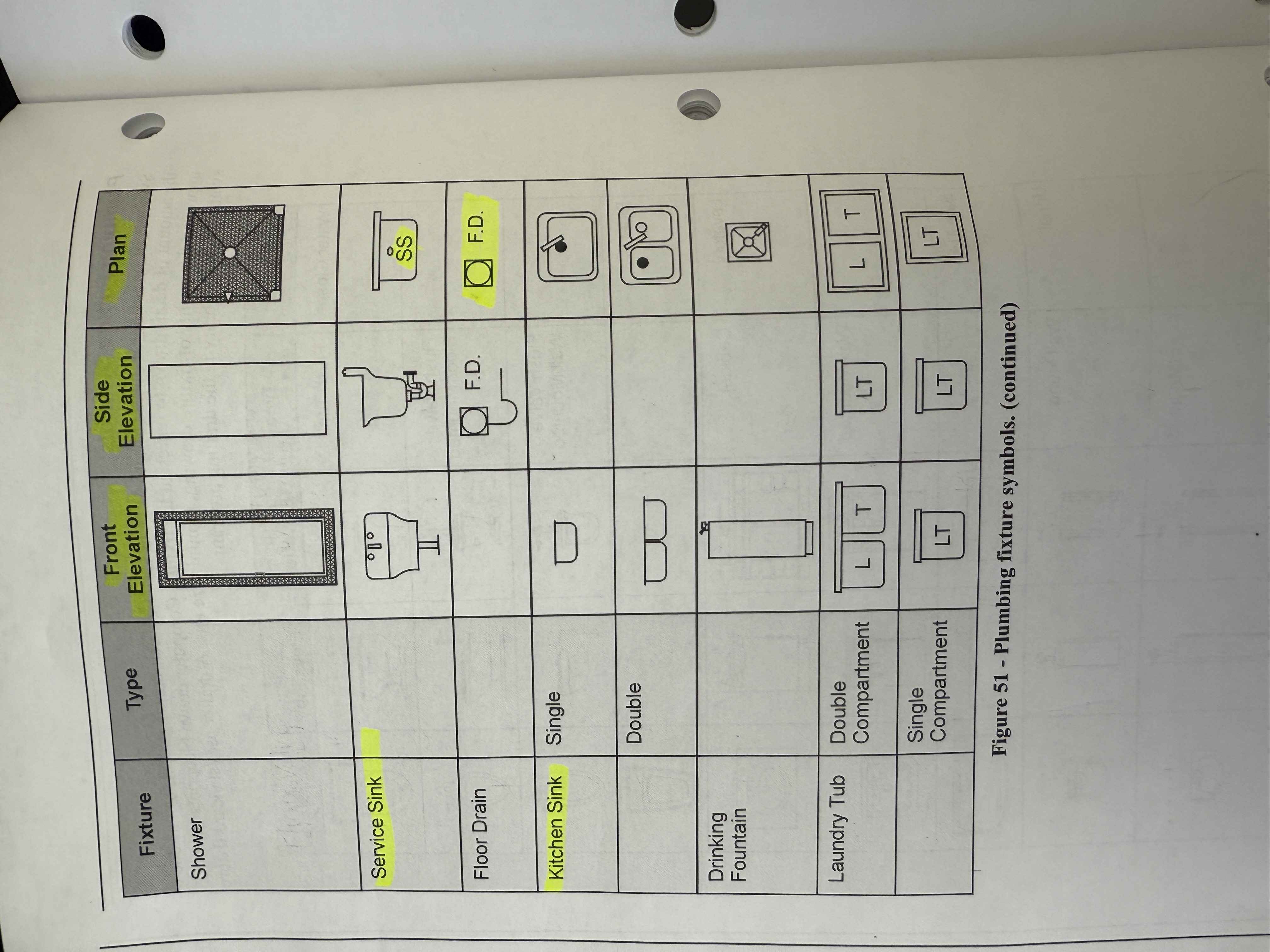
floor plan- interior plan view of building. Locate walls, doors, windows, plumbing fixtures, furnaces, hot water tanks.
exterior elevation - indicated by orientation- exterior walls and elevations, vent terminals, rainwater leaders, roof penetrations
Interior elevation- inside walls, sections of interior like bathrooms and kitchens
Details- close up view of construction, enlarged aread circled and tagged via identification bubble.
window/door finishing schedules - size and desc for windows, doors, wall finish. Usually table form with a number and letter.
Structural- letter S followed by number
May be incorporated into architectural drawing
structural, load bearing, trusses, footings, columns
Mechanical- M, or P (plumbing), H (HVAC), FP (fire protection) followed by nunber
plumbing, hot water, hvac, fire protection
Piping, ductwork, drainage, venting, utilities
Sometimes routing is up to plumber,
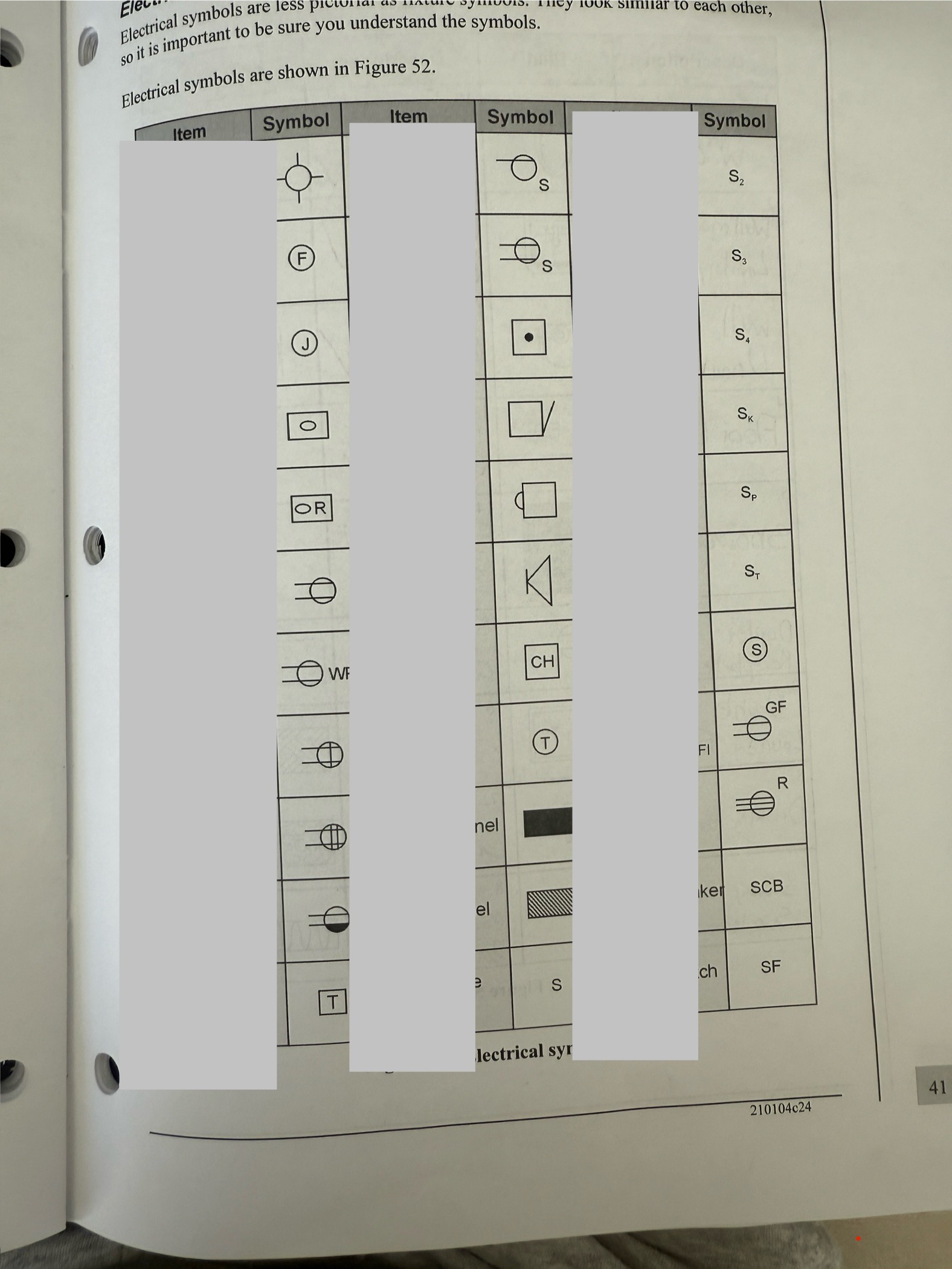
Electrical - not touched on, doesnt mention letter
Landscaping - doesnt mention letter
grade (ground elevation) , sidewalks, patios, gas lines under driveways, rainwater leader terminations
What is the difference between Imperial and Metric scales?
Imperial is based on fractions of an inch per foot, while Metric uses a numerical ratio, such as 1:100.
What information does the building site plan include?
Address/legal description, overhead view of the building site, building orientation, utility orientation, drawing scale, geodetic elevations.
What does an exterior elevation show?
It shows exterior walls, vent terminals, rainwater leaders, and roof penetrations.
What is the purpose of the detail section in construction drawings?
It provides a close-up view of construction, with enlarged areas circled and tagged via identification bubble.
How are interior dimensions usually measured?
From the centre of the partition or to the face of the wall.
What should be avoided in orthographic dimensions?
Keep dimensions as simple as possible and avoid showing duplicates to reduce confusion.
Where is the scale found on drawings?
Title Block
How many distinct types of notes can be on a drawing?
2= general and local
Legend vs Schedule
Legend is more of a list describing all types of symbols used
Schedule is used more to describe type of material used (ex - types of doors, windows)
When referring to specifications - what does CSI mean? Which division is plumbing under?
Construction Specification Institute.
Divides construction into divisions, each division it describes the type of work and who is to perform the work. Latest CSI has 50 divisions.
Plumbing specs is division 22.
Local Notes vs General Notes on a drawing?
Local note - applies only to the item indicated by the leader line. Does not apply to other items.
General note - applies to blueprint in general and not 1 specific item.
How are housing blueprints usually organized?
Typically organized by stages of construction
What do site or plot plans show? What key info do they convey?
Entire building site and surrounding areas. (Outline of building and perimeter of site)
Key info - the elevation of the main floor and the legal description of the property.
What does the 4th meridian run through? What about 5th?
4th - separates alberta from saskatchewan
5th - passes through calgary
Latitude and Longitude - alternative names?
Latitude (runs east to west) - parallels
Longitude (runs south to north) - meridians
Which parallel separates canada from united states?
49th
Alberta Township lines
North-South = Range lines
East-West = Township lines
Each parcel formed of these is called a township.
A township is approx. 6 miles on each side. Each section of a township is 1 by 1 miles (1 mile² area).
A 36 section grid made of township lines and range lines is known as a township.
Architectural vs Geodetic Elevations?
Geodetic - Starts at sea level
Architectural - Elevation starts from main floor (usually) and is usually assigned 100 feet or meters to keep it easy to work with. This way it is easier to work with on site.
What are contour lines when describing elevation?
Lines that show areas having the same elevation. The close together, the rate of slope increases.
Different styles may exist - one may be for an existing elevation of the site, and a second for the finished grade elevation upon completion of construction.
Detail drawings are drawn to _____ scale.
Larger scale to illustrate component construction.
Metric dimensions - units are usually ____ shown.
not shown (not sure why)
Building dimensions are usually from the ___ wall to the edge or center of opening or interior walls
Exterior wall to the edge or center of opening or interior walls.
True or False - In orthographic drawings - views should share common dimensions.
True, but keep as simple as possible. Avoid duplicate dimensions as they mislead reader. Top and Front typically share common dimensions.
Top, front, right side views - which ones typically share which dimensions?
Top = Depth and Width
Front= Height and Width
Right Side = Height and Depth
What are common scales used in residential blueprints?
1/4'“ per foot, 1:50 or 1:100
Label

Label
Label
Label
Drawings that show the front and side views are known as ___ drawings
Elevation
If there is a discrepancy between scale ruler and dimension on drawing, which one do you use?
The drawing dimension
What dimension is common between front and top in orthographic?
Width
Which dimension is between front and right side views in orthographic?
Height
What is a blueprint?
Visual set of instruction
Is the main floor a continuation of basement?
Yes
A geodetic elevation of 1300 feet would be what in modified in modified geodetic?
300 feet
Where is the imaginary cut in a floor plan?
3 to 4 foot above floor level