Hazards
1/57
There's no tags or description
Looks like no tags are added yet.
Name | Mastery | Learn | Test | Matching | Spaced | Call with Kai |
|---|
No analytics yet
Send a link to your students to track their progress
58 Terms
Introduction to hazards
natural hazard → a natural event that has the potential to threaten both life and property.
natural disaster → using Degg’s Disaster model, when a vulnerable population is exposed to a natural hazard.
Types of natural hazard
Geophysical → hazards caused by land processes, majorly tectonic plates e.g., volcanoes.
Atmospheric → hazards caused by atmospheric processes and the conditions created because of these, such as weather systems e.g., wildfires, tropical storms & droughts
may be seasonal
advanced prediction systems e.g., satellite technology.
but climate change is increasing the frequency and intensity of these hazards.
Hydrological → hazards caused by water bodies and movement e.g., floods & storm surges
human actions affect this hazard e.g., permeable surfaces.
management includes flood forecasting, levees, and sustainable urban drainage systems (SuDS).
Hydrometeorological → hazards that are both atmospheric and hydrological due to a mixture of geographical processes e.g., tropical storm.
Economic and cultural determinants of hazard perception: wealth & experience
wealth - a wealthier population may perceive a hazard with less risk as they are less vulnerable e.g., can afford hazard-proof resources.
experience - people who have experienced hazards will understand its full effect. But studies show experienced people may have an optimistic/unrealistic view on hazards due to the “lightning never strikes in the same place” mentality.
Economic and cultural determinants of hazard perception: religion/belief, education & mobility
education - a more educated population will understand a hazard’s full effect.
religion/belief - religious people believe hazards are the natural circle of life so may not perceive it as negative. But people who support environment conservation may view hazards as a risk (especially with the frequency/intensity increasing with climate change).
mobility - people with limited access to escape a hazard may perceive it as a greater threat e.g., living in a secluded location or disability/illness.
Human responses to hazards: passive
fatalism → the idea that hazards are unnatural, uncontrollable events and that any losses should be accepted as there nothing you can do to stop them.
Little or no effort made to prepare or mitigate.
More common in poorer or rural communities, or where there is strong religious belief.
It often occurs where there is limited hazard education, so people don't fully understand risks.
Human responses to hazards: active
prediction → using scientific research to predict when hazards occur to reduce impacts, and maybe prevent it.
Reduces vulnerability by enabling evacuation or emergency services to prepare in advance.
Depends on funding and infrastructure, so more effective in HICs than LICs.
Prediction enhances public confidence and can reduce the emotional impacts of hazards.
adaption → learning to live with a hazard by adjusting lifestyle choices e.g., earthquake-proof houses.
Encourages investment in engineering solutions, like earthquake-proof buildings or flood barriers.
May include changing farming practices, e.g. drought-resistant crops
involves hazard mapping for building infrastructure.
mitigation → strategies used to lessen severity of a hazard e.g., sandbags.
Includes natural strategies, like afforestation to reduce flood risk and carbon emissions.
Involves engineering interventions, e.g. tsunami sea walls.
Can be expensive and politically sensitive, especially in densely populated or economically weak areas.
management → coordinated strategies to reduce a hazard’s effect inc. adaption, mitigation & prediction.
risk sharing → a form of community preparedness where a population shares the risk posed by a hazard e.g., New Zealand take taxes & insurance to invest in hazard management.
Can build a sense of resilience and solidarity, helping recovery and rebuilding efforts post-disaster.
Helps protect the most vulnerable by pooling risk across society.
Aspects of a hazard and how they affect human responses: incidence and distribution
Incidence → the frequency of a hazard.
low incidence hazards may be harder to predict and will have less management strategies, potentially being more catastrophic.
low incidence are usually more intense as high incidence hazards e.g., there’ve been 36 earthquakes recorded since 1500 with magnitude 8.5+. But millions of earthquakes, too weak to be recorded, are thought to happen every year.
Distribution → where hazards occur geographically.
areas of high hazard distribution are more likely to have many management strategies with those living there being adapted to the hazardous landscape.
Aspects of a hazard and how they affect human responses: magnitude, intensity & level of development
Magnitude → the size of a hazard & definable by a number
Intensity → the power of a hazard & is the effects on the person
high magnitude/high intensity will have worse effects, and will have more management e.g., more mitigation strategies needed to lessen the effects.
Level of development:
a hazard of the same magnitude may have different effects in 2 areas of contrasting levels of development.
the area with a lower LOD is less likely to have management strategies due to higher costs, and so the effects may be more catastrophic.
But there are HIC countries that aren’t as prepared for hazards due to a lack of management strategies, especially in multi-hazard environments where resources are spread thinly over the various hazards.
e.g., Canada wildfires increasing, not enough money and resources for earthquakes and tsunamis.
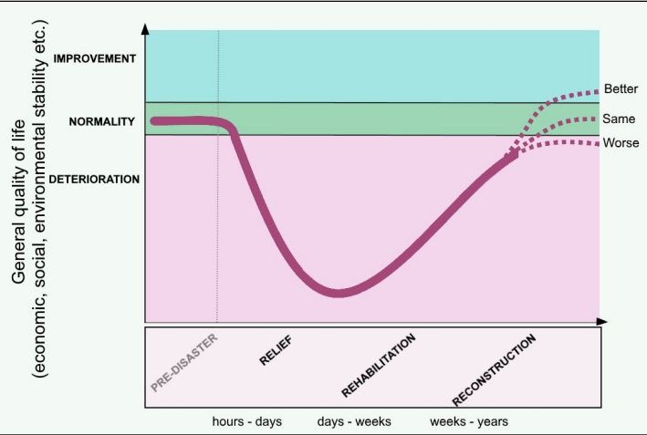
The park model
The park model → a geographical representation of human response to hazard.
the steepness of the curve shows how quickly an area deteriorates and recovers.
the depth of the curve shows the scale of the disaster e.g., the lower the curve, the lower the quality of life.
stage 1: relief → hours-days | immediate response e.g., search & rescue.
stage 2 rehabilitation → days-weeks | temporary shelters set up, food and water distributed, services restored.
stage 3 reconstruction → weeks-years | mitigation efforts introduced, houses rebuilt, back to same or similar quality of life
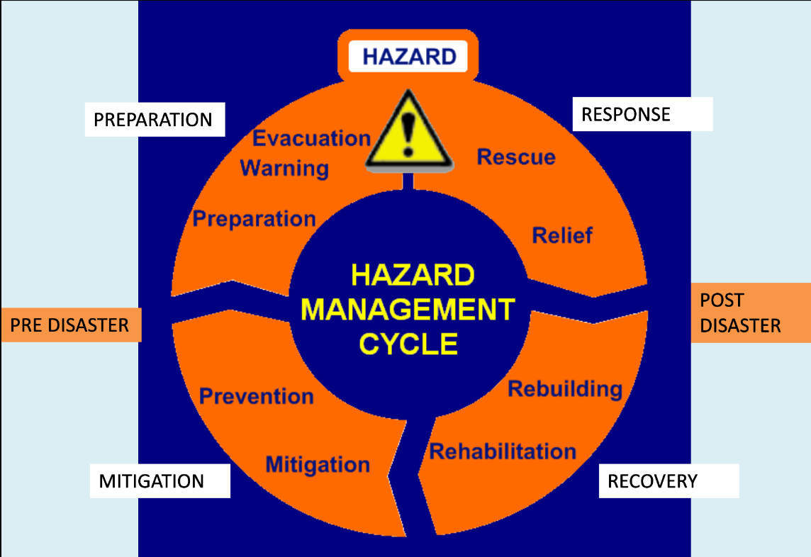
The hazard management cycle
The hazard management cycle:
response - immediate action after the event e.g., evacuation, rescue.
recovery - long-term responses e.g., restoring service, construction.
mitigation - strategies to lessen effect of future hazard e.g., warning systems, resources distributed.
preparedness - being ready for a future event e.g., education, training.
Structure of the earth
Inner core:
solid ball of iron/nickel
very hot due to pressure and radioactive decay (elements like uranium give off heat when they decompose).
Outer core:
made of iron/nickel
semi-molten
Mantle:
widest part of the earth (2900km)
mainly solid rock, high in silicon.
top layer is semi-molten magma aka the asthenosphere.
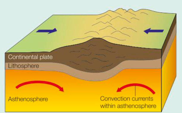
Asthenosphere:
semi-molten layer that moves due flows of heat aka convection currents.
movements powered by heat from the core.
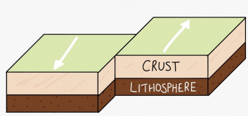
Lithosphere:
broken up into plates
Crust:
oceanic crust is denser and can be destroyed.
made of a basaltic layer called sima (silica & magnesium).
continental crust is less dense and not destroyed.
made of a granitic layer called sial (silica & aluminium)
Plate tectonic theory of crustal evolution
Plate tectonic theory:
In 1912, Alfred Wegener put the idea of “continental drift” forward.
He suggested that 250 million years ago, the continents were all grouped together as a supercontinent called “Pangea” and overtime, they have drifted to their current configuration.
Reasons for unsupported evidence
Alfred Wegener was very young (early 30’s) stereotypically believed that younger people didn’t have the same knowledge or experience as someone much older.
He was a meteorologist and wasn’t a classically trained geologist professionals looked at him and his theories with suspicion.
He couldn’t come up for the reason of continental drift he didn’t propose a hypothesis for “why” the continents had drifted apart.
Plate tectonic theory of crustal evolution: continental drift as evidence
The current continents (especially Africa and South America) looked like they “fit together”.
Geographical evidence:
Evidence of a late Carboniferous glaciation in South America, Antarctica and India. The presence of the deposits can’t be explained in its current position. With the shape of Pangea, the glaciation creates a radial shape, close together.
Rock sequences in Northern Scotland are of those similarly found in Canada, indicating they formed in similar conditions.
Biological evidence:
Fossil remains of the reptile Lystrosaurus are found in Africa, India and Antarctica. It is unlikely that the reptile could swim.
Fossil remains of the same plant Glossopteris found across several continents. These plant seeds are heavy and not windborne across oceans.
Plate tectonic theory of crustal evolution: seafloor spreading as evidence
In the 1960’s Harry Hess and Robert Dietz proposed the sea floor spreading hypothesis that there was new crust formation at the mid-ocean ridges and there was subduction of older crust at the trenches. Also, that the whole sea floor was moving outwards from mid-ocean ridges, widening the sea floor.
The age of the seafloor rock increases as you get further away from the mid-ocean ridge, therefore the plates must be moving.
The thickness of the sediment deposited on the ocean floor increases as you get further away from the mid-ocean ridge, as older rock has more time to accumulate sediment.
Patterns of seafloor magnetism on either side of mid-ocean ridges match up with one another.
Plate tectonic theory of crustal evolution: convection currents as evidence
Hotspots around the core heat the lower mantle, creating convection currents.
The hot magma rises through the asthenosphere as it becomes less dense (as particles spread out).
Magma gets cooler at the top of the asthenosphere due to being further away from the heat source.
It then becomes denser, causing the magma to sink down to the bottom of the asthenosphere.
Cooler magma reheats again and the cycle continues, which is known as convection currents.
Plate tectonic theory of crustal evolution: gravitational sliding as evidence
Refers to the movement of tectonic plates under gravity, particularly where plates slide down from elevated positions like ocean ridges.
Occurs as the thickening and cooling lithosphere becomes heavier over time, pulling the plate sideways and downward.
Explains the lateral movement of plates on top of the asthenosphere as it sinks under its own weight.
Often overlaps in meaning with ridge push, but may also apply to continental lithosphere moving from elevated areas.
Plate tectonic theory of crustal evolution: slab pull as evidence
At mid-ocean ridges, new lithosphere forms. This area is quite hot due to decompression melting.
As the plates move away from the mid-ocean ridge, the plates get older, denser, cooler and will sink (heavier).
Also, the further away from the mid-ocean ridge, the depths to the ocean floor gets deeper, because the oceanic lithosphere is sinking more deeply into the mantle
When the lithosphere gets so deep and encounters another tectonic plate, it will slide underneath that plate as it’s so heavy.
This subduction process will pull the rest of the plate down with it into the mantle.
The change in density acts as a driver for plate movement.
Plate tectonic theory of crustal evolution: ridge push as evidence
The plates are moving apart due to slab pull, causing decompression melting in the mantle.
Magma rises through the gaps, forming new lithospheric plates
Pushes plates apart as ridge push.
As the oceanic lithospheric plates move further away from the mid-ocean ridge, the plates get older, denser, cooler and will sink (heavier).
The oceanic lithosphere wants to slip away from the mid-ocean ridge because it’s getting heavier and gravity causes it to slip away.
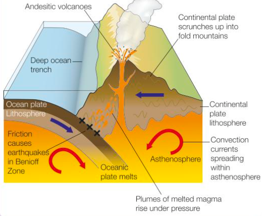
Destructive (oceanic – continental)
The oceanic plate is denser than the continental plate, which causes the oceanic plate to subduct underneath the continental plate.
The point of collision is marked by the bending of the oceanic plate to form a deep ocean trench e.g., Peru-Chile trench along the Pacific coast of South America.
The two plates then converge, causing the continental land mass to become uplifted, compressed, buckled and folded into chains of fold mountains e.g., Andes.
The sinking oceanic plate begins to melts at depths beyond 100km, and is completely destroyed by 700km. This zone of melting is called the Benioff Zone.
Melting is caused by both increasing heat at depth and friction.
The friction can lead to, built up tension, which can be released as intermediate or deep-focus earthquakes.
The melted oceanic plate creates magma, which is less dense that the surrounding asthenosphere, & so rises in great plumes.
The magma that passes through the cracks in the buckled continental plate, may reach the surface to form explosive volcanic eruptions.
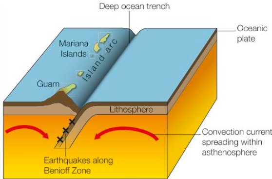
Destructive (oceanic – oceanic)
When 2 oceanic plates collide, the faster/denser plate subducts underneath the other.
This leads to the formation of a deep ocean trench.
The rising magma from the Benioff Zone forms crescents of submarine volcanoes along the plate margins which grow to form island arcs e.g., The Mariana Islands.
Destructive (continental – continental)
Continental plates are less dense that the asthenosphere below, so subduction does not occur.
The colliding plates become uplifted and buckle to form high fold mountains e.g., Himalayas.
Volcanic activity doesn’t occur at this boundary because there isn’t any subduction, but shallow-focus earthquakes can be triggered.
Young fold mountains are continually compressing and growing higher.
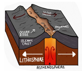
Constructive (oceanic – oceanic)
2 oceanic plates separate, this allows magma to rise between the gap and cool down to form new land.
Less explosive underwater volcanoes form as magma rises.
New land forms on the ocean floor by basic lava filling the gaps, this is knowns as sea floor spreading (as the floors spreads and gets wider).
E.g., Mid-Atlantic Ridge
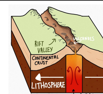
Constructive (continental – continental)
When the continental plates separate, any land in the middle of the separation is forced apart.
The stretching and collapsing of the crust create rift valleys e.g., The Great African Rift Valley.
The lifted areas of rock are known as horsts, whereas the valley itself is known as a graben.
Where magma rise between the gaps of the plates, volcanoes form.
Eventually the gap may fill with water and completely separate from the main island.
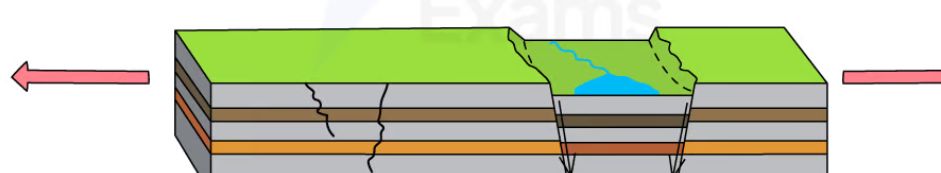
Conservative
When 2 parallel plates slide past each other.
Crust is not being destroyed by subduction along these margins.
As there is no melting of rock, there is no volcanic activity or formation of new crust.
These margins are still extremely active and are associated with powerful earthquakes.
Friction between the 2 plates causes a build-up of tension and pressure.
This pressure may be released as sudden, powerful shallow-focus earthquakes e.g., San Andreas Fault in LA.
Characteristic processes: seismicity and vulcanicity
Seismicity → ground shaking:
occurrence → primarily along plate boundaries, where tectonic plates interact (convergent, divergent, and transform).
causes → stress and pressure build-up as plates move or collide, eventually leading to the rupture of rocks and the release of seismic energy.
Vulcanicity → volcanic activity:
occurrence → primarily at plate boundaries, particularly at constructive and destructive margins, and sometimes at hotspots within plates.
causes → magma, molten rock from the Earth's mantle, rises to the surface due to its lower density and the movement of tectonic plates.
Associated landforms: fold mountain formation
Fold mountains form along both destructive and collision plate boundaries.
They form when 2 plates with landmasses on them move towards each other.
The plates push layers of accumulated sediment in the sea into folds between them, becoming a fold mountain range.
Most fold mountains continue to grow as the plates move constantly move.
E.g., Himalayas & Andes.
Associated landforms: rift valley formation
Form at constructive margins.
Continental divergence forms massive rift valleys.
The valleys form when the lithosphere stretches, causing it to fracture into sets of parallel faults.
The land between the faults collapses into deep, wide valleys that are separated by upright blocks of land called horsts
E.g., The Great African Rift Valley.
Associated landforms: ocean ridge formation
An ocean ridge forms when diverging plates are under the ocean.
These form chains of submarine mountain ridges that extend for thousands of metres across the ocean floor.
Regular breaks called transform faults cut across these ridges.
These faults may widen at different rates, leading to frictional tension building up.
Shallow-focus earthquakes release this tension.
The middle of the ridge is marked by deep rift valleys.
Overtime, the rift valleys widen by rising magma from the asthenosphere, which cools and solidifies to form new crust – due to decompression melting.
E.g., Mid-Atlantic Ridge that extends from the north to the south of the Atlantic Ocean.
Associated landforms: deep sea trench formation
Ocean trenches are deep water areas that run along a coastline that has a destructive plate margin.
They are created by subduction, when a denser oceanic plate melts underneath a less dense continental plate.
Trenches occupy the deepest layer of the ocean with intense pressure and lack of sunlight.
E.g., Mariana Trench.
Associated landforms: island arc formation
Island arcs are major structures of ocean basin features.
They are long, typically curved, volcanic island chains found on the basin margins.
Hot spots in the earth’s core causes intense heating of mantle.
The heat causes magma to rise and break the sea floor, forming a volcano.
Due to tectonic movement, the crust moves over the hotspot and consequently heats and forms a new volcano.
The old volcano is now dormant and disused and is now an island arc.
E.g., Mariana Islands
Associated landforms: volcano formation
Refer to destructive plate boundary.
Mantle plumes and their relationship to plate movement:
Radioactive decay within the earth’s core generates very high temperatures.
If decay is concentrated, hotspots will form around the core.
These hotspots heat the lower mantle creating localised thermal currents, where magma plumes rise vertically.
Although they are usually found close to plate margins, they can occasionally rise within the centre of the plates and “burn” through the lithosphere, creating volcanic activity on the surface.
E.g., Hawaiian Islands.
Forms of volcanic hazards: Nuees ardentes, lava, mudflows / lahars
Nuees ardentes:
clouds of burning hot ash and gas that collapse down a volcano at high speeds.
they average 60mph but can reach 430mph.
often exceed 600C
they are 1 of the deadliest volcanic hazards - travel long distances & destroy everything in their path.
E.g. when Fuego volcano erupted in Guatemala in 2018, nuees ardentes destroyed several nearby towns
Lava:
lava is fast or slow depending on viscosity.
silica makes lava viscous & slow.
basic lava is very hot & fluid.
can create wildfires if come into contact with something flammable.
e.g., In the 2021 eruption of Mount Nyiragongo in the Democratic Republic of Congo, lava flows travelled almost 10km destroying properties and killing over 30 people
Mudflows / lahars:
mudflows are a mix of water & ash.
many reasons for this but mainly due to melting ice at high latitudes.
can be dangerous as well - fast flowing
e.g., when Mount Pinatubo erupted in the Philippines in 1991, lahars caused extensive damage and disruption.
Forms of volcanic hazard: pyroclastic / ash fallout, gases /acid rain, tephra
Pyroclastic / ash fallout:
ash → microscopic shards of glass.
they spread in the atmosphere due to wind currents, enveloping the planet.
can be hazardous to humans - respiratory problems.
problems in aviation industry - ash clogs engines.
climate change - Mt. Pinatubo caused 0.5C fall in global avg. temps. for 3-4 years.
ash in super eruptions - volcanic winter.
Gases / acid rain:
toxic gases can be released during eruption, even CO2 can be toxic as it replaces oxygen which is heavier.
acid rain caused when gases e.g., sulphur dioxide dissolve in rainwater.
It can damage crops, forests and aquatic ecosystems
Tephra:
rocks that are ejected from a volcano.
size can vary from large boulders to pebbles.
prevailing winds affect tephra deposit.
Tephra can also contribute to the formation of new landforms, such as cinder cones.
Spatial distribution and magnitude of volcanic hazards
Spatial distribution:
occur on destructive & constructive plate boundaries and on hotspots.
Magnitude:
vulcanicity measured using volcanic explosivity index VEI.
logarithmic scale of VEI 2 onwards.
measures how much tephra deposited, how high tephra is ejected, and the length of the eruption.
Frequency, regularity & predictability of volcanic hazards
Frequency:
frequency depends on if volcanoes are dormant, active or extinct.
estimated 50-60 volcanoes erupt each month.
low frequency volcanoes are usually more explosive.
high frequency volcanoes are usually more effusive.
Regularity:
volcanic eruptions are regular, with eruptions on the same boundary being similar.
e.g., volcanoes on destructive boundaries are regularly more explosive.
but sometimes may be irregular and not fit patterns.
Predictability:
hard to predict
scientist can look at ground elevation and release of gases for some indication.
Forms of seismic hazard: earthquakes
Involves a sudden, violent shaking of the ground when tectonic plates move.
The plates can become locked together, causing stress and pressure to build.
The stress eventually become so great that the rock fractures, releasing all the pent-up pressure.
This causes intensive ground shaking for seconds to minutes.
The focus → the point at which the earthquake starts below the earth’s surface.
The epicentre → the point on the earth’s surface directly above the focus.
Forms of seismic hazard: shockwaves
When 2 plates move side by side, causing friction to build up and pressure to increase (pressured is stored as potential energy).
The plates eventually move when the pressure becomes too much.
All that energy is transferred into kinetic energy which is released, sending vibrations through the ground.
The further away from the focus, the weaker the shockwaves, as energy is transferred into the surroundings.
Separated into P waves (primary) and S waves (secondary).
Forms of seismic hazard: tsunamis
When an oceanic crust is jolted during an earthquake, causing all the water above the plate to be displaced.
The water travels fast but with a low amplitude (height).
As the water gets closer to the coast, the sea level decreases, allowing there to be friction between the sea bed and the waves.
This causes the waves to slow down and gain height, creating a wall of water than is an average of 10 feet high (but can reach 100 feet).
Forms of seismic hazard: liquefaction
When soil is saturated, the vibrations of an earthquake cause it to act like a liquid.
The soil becomes weaker and is more likely to subside when it has large weight on it.
e.g., in the 2011 Christchurch earthquake in New Zealand, significant liquefaction caused damage to approximately 20,000 properties
Forms of seismic hazard: landslides and avalanches
Refers to movement in the soil or snow, causing it to become unstable.
A landslide is the downward movement of soil and rock on a slope.
The intense shaking during an earthquake may trigger the collapse of material downhill
The risk of landslides is greater where soils are looser, slopes are steeper and where the shaking lasts longer or is particularly intense
e.g., The 2015 Gorka earthquake in Nepal also triggered more than 3000 avalanches and landslides
Spatial distribution and magnitude of seismic hazards
Spatial distribution:
Seismic hazards occur along all boundaries.
Seen by the ‘Ring of Fire’ which accounts for 90% of the world’s earthquakes.
The Alpine-Himalayan belt accounts for 5-6% of the world’s earthquakes.
Magnitude:
Logarithmic Richter Scale → seismicity is measured using this scale and is a measure of the strength of seismic waves.
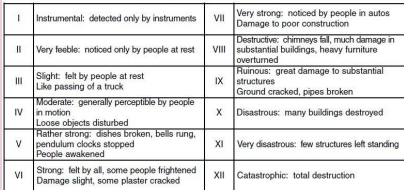
Modified Mercalli Scale → also used, which is a rate of destruction. Unlike the Richter Scale, it has a definite end (at 12). The scale is subjective, so it’s sometimes disputed as it’s dependent on human development being present rather than the strength of the seismic waves.
Frequency, randomness/regularity and predictability of seismic hazards
Frequency:
Earthquakes are frequent around the world and occur every day at boundaries.
Hundreds of smaller magnitude earthquakes, that cannot be felt by humans, occur every day.
But large earthquakes are less frequent.
Regularity and randomness:
Earthquakes follow no pattern and are random, so there is irregularity between events.
Predictability:
Earthquakes are almost impossible to predict.
Microquakes may give some indication.
But the magnitude cannot be predicted as how strong they are, is random.
However, you can monitor ground shaking or vibrations in the ground to get a rough idea of when an earthquake can occur.
The nature of tropical storms and their underlying causes
Tropical storms:
Tropical storm → a low-pressure, spinning storm with high winds and torrential rain.
Underlying causes:
Temperature → ocean temps must be around 26-27C and at least 50m deep – as warm water provides the storm with energy.
Air pressure → must be in areas with unstable pressure, usually where areas of high pressure and low pressure meet (convergence). This is so warm air rises more readily because it less dense than cold air. Clouds can also form when the air is humid.
Wind shear → winds must be present for the swirling motion to forms, but cannot be too strong or the storm system will be ripped apart in the early stages.
Rotation → tropical storms don’t form directly on the equator but rather 5 on either side. This is due to the Coriolis Effect which is the effect of the earth’s rotation on weather events. So, the storm spins as the earth is spinning but there is no Coriolis Effect on the equator hence why tropical storms don’t form there.
A trigger → a pre-existing thunderstorm, a spot of very high sea surface temp, an area of low pressure and many other factors can act as a trigger for a storm to develop. This will only further develop when the other conditions are present
Forms of storm hazards: high winds
Tropical storms are powerful with over 300km/h winds.
Hurricane winds are strong enough to blow houses down and blow heavy debris at high speeds which is a serious threat to human life.
They can bring down electricity power lines and devastate agricultural areas.
Forms of storm hazards: storm surges
Storm surges → a surge of high water, typically up to 3m high which sweeps inland from sea.
Occurs when the storm reaches the coast, flooding low-lying areas.
This is caused by a combination of the intense low atmospheric pressure of the tropical storm, with the powerful driving surface winds.
They can cause loss of life, inundate agricultural land with saltwater and debris, and destroy housing and infrastructure.
Forms of storm hazards: coastal/river flooding
Coastal and river flooding comes from storm surges and heavy rain.
Warm humid air can generate torrential rainfall often exceeding 200mm in just a few hours.
This can lead to flash flooding, especially in urban areas where surface water can overwhelm drainage systems.
River flooding also sends more floodwater to other places, causing area outside of the tropical storm paths to flood also.
Flood hazards increase with impermeable surfaces, high density of buildings and urbanisation.
Forms of storm hazards: landslides
Caused by soil becoming heavy when wet with high levels of rain.
Intense rainfall increases pore water pressure, weakening cohesion and triggering slope failure.
High winds can also remove vegetation cover, reducing ability for the soil to bind together
E.g., Hurricane Maria in Puerto Rico in 2017, caused extensive landslides, resulting in many deaths and damage to infrastructure.
Spatial distribution and magnitude of storm hazards
Spatial distribution:
Typhoons are found in the South China Sea and West Pacific Ocean.
Hurricanes are found in the Gulf of Mexico, Caribbean Sea and West Coast of Mexico.
Cyclones are found in the Bay of Bengal, Indian Ocean and Northern Australia.
Tropical storms are not found on the equator as there is no Coriolis Effect.
Magnitude:
The intensity of a storm hazard is measured using the Saffir-Simpson scale which is based on wind speeds.
Ranges from category 1 to category 5 (the higher the numbers the stronger the storm).
They are considered major when reaching category 3 with wind speeds between 111-129 miles an hour.
Frequency and regularity of storm hazards
Frequency:
Tropical storms are relatively frequent but can vary significantly from year to year.
On average, there are about 80 tropical storms a year.
Regularity:
Tropical storms are irregular because although they occur in the same areas, their path does not follow a set route – the route taken is dependent on the storm and the climatic conditions.
In the Northern Hemisphere, tropical storm season runs from June to November, with the peak months falling in August, September and October.
In the Southern Hemisphere, the season runs from November to April, with peak months falling in January, February and March.
Predictability of storm hazards
Tropical storms form away from land, meaning satellite tracking of cloud formations and movement can be tracked and the general route can be predicted.
Prediction of tropical storms involves gathering data from a wide range of sources, such as satellites, weather balloons, radar and ocean buoys.
This data includes atmospheric pressure, wind speed and direction, humidity, sea surface temps and ocean currents.
Although these models are sophisticated predictions aren’t always accurate, especially over the longer term.
The closer the hurricane gets, the easier it is to predict.
Strom surges can also be predicted based on the pressure and intensity of the storm.
Past storms and climatic trends can be used to predict the probability of a storm hitting an area.
But forecasts have to be accurate – in the US, its costs $1 million per km of coastline to evacuate due to losses in businesses etc.
The NOAA cannot predict likely landfall or levels of activity for particular locations until the final few days before landfall occurs.
Nature of wildfires
Wildfire → A large, uncontrolled fire that quickly spreads through vegetation.
Ground fires → burn beneath the ground surface with tree roots and peat layers burning.
They are smouldering, slow-moving fires that can burn for days and weeks with no visible flame and little smoke.
Surface fires → burn through low-lying vegetation such as grass, bushes and small trees.
They are the most common and can move quickly.
Crown fires → burn through the canopy layer (top layer of vegetation).
They are usually the most dangerous and destructive type of wildfire because they move quickly and often produce intense heat and flames.
Conditions favouring intense wildfires: vegetation type
Denser, thicker, close together vegetation → more intense fires that can spread quickly and burn for longer e.g., forest fires tend to be more dangerous and intense that grassland fires.
Vegetation with flammable oils e.g., eucalyptus → also causes more intense wildfires as they burn very easily.
Conditions favouring intense wildfires: fuel characteristics
The amount of available fuel e.g., trees, grass and dead plant material, affects the likelihood and severity of fires.
Fine, dry material e.g., grasses and twigs, can catch fire and burn very easily.
Conditions favouring intense wildfires: climate and recent weather
Dry weather and droughts → dry out vegetation and increase its flammability.
High temperatures and heatwaves increase rates of evaporation → dries out vegetation even more and make it more susceptible to ignition.
Strong winds → fan the flames of a fire and cause it to spread more quickly. Wind can also carry embers from a fire and start new fires elsewhere.
Lightning storms → common cause of wildfire ignition.
Climate change → increases frequency and intensity of wildfires in many regions around the world as well as increase length of wildfire seasons e.g., La Nina events where there is a dry season
Conditions favouring intense wildfires: fire behaviour
Fires can spread quickly on hills as the heat rises e.g., The Carr Fire in California 2018 spread rapidly uphill due to strong winds and dry vegetation.
Fires can ‘jump’ across rivers and into areas due to lit debris, causing spread of distant vegetation.
Fires that have multiple fronts can change direction quickly and move unpredictably.
More intense fires with higher flames can ignite trees and other vegetation causing them to spread more quickly and burn more intensely.
Causes of fires: natural and human agency
Natural causes:
Lightning strikes
Especially in dry areas with little rain e.g. boreal forests
Volcanic eruptions
Rare, but possible in places like Hawaii or Iceland.
Heat from the sun
Human causes:
Out of control campfires / barbecues
Discarded cigarettes which are still lit
Sparks from machinery or power lines
Slash and burn farming techniques
Common in the Amazon, Indonesia, and parts of Africa.
Arson → when people start fires on purpose.
Often for political, economic, or personal motives.
Climate change is a human cause that increases intensity and frequency