AP Human Unit 4 MCQ Test Bank
1/54
There's no tags or description
Looks like no tags are added yet.
Name | Mastery | Learn | Test | Matching | Spaced | Call with Kai |
|---|
No analytics yet
Send a link to your students to track their progress
55 Terms
At some point in their recent history, all of the following countries became divided into two political entities as a result of cultural or ideological conflict EXCEPT
Responses
A
Korea
B
Vietnam
C
Germany
D
Ireland
E
Japan
Japan
Which of the following groups represents a nation without a state?
Responses
A
Kurds
B
Israelis
C
Turks
D
Germans
E
Albanians
Kurds
Which of the following is an example of Balkanization?
Responses
A
Greece
B
Hungary
C
Albania
D
Yugoslavia
E
Romania
Yugoslavia
Based on the map, which of the following can be identified as a true statement about Northern Ireland?
Responses
A
It is united with the rest of the island to form a sovereign nation-state.
B
It forms its own sovereign nation-state predominately made up of the Irish ethnic group.
C
It is a frontier that is not formally part of a state, but the United Kingdom claims the area.
D
It is physically separate from the rest of the United Kingdom, a multinational state.
E
It is a stateless nation, as the entire island of Ireland is under the control of the United Kingdom.
It is physically separate from the rest of the United Kingdom, a multinational state.
Which of the following best explains why the region of Catalonia in Spain could be a viable country?
Responses
A
Catalonia is linguistically distinct compared to other regions in Spain.
B
Catalonia is well developed economically compared to other regions in Spain.
C
Catalonia's population is ethnically distinct compared to other regions in Spain.
D
Catalonia has a large population compared to other regions in Spain.
E
Catalonia has a major city, Barcelona, which has a notoriety comparable to that of the Spanish capital, Madrid.
Catalonia is well developed economically compared to other regions in Spain.
The Berlin Conference established the borders of North African countries including Egypt, Libya, and Sudan. The landscape of these countries influenced the types of boundaries imposed by the European colonial powers. Which of the following boundary types best explains the influence of landscape on the political borders of the North African region?
Responses
A
Antecedent, based on tribal cultural boundaries that existed before European colonization
B
Subsequent, with smaller buffer states placed between larger states to prevent political conflicts
C
Consequent, accounting for local differences in language and religion during European colonization
D
Natural, with irregular lines, accounting for regional physical features such as mountains or water bodies
E
Geometric, with straight lines, disregarding physical features or tribal cultural differences of the areas
Geometric, with straight lines, disregarding physical features or tribal cultural differences of the areas
The United Nations Convention on the Law of the Sea sets the limit of the exclusive economic zone at 200 nautical miles from a country's coastline. In cases where countries are less than 400 nautical miles apart at sea, which of the following explains how the exclusive economic zone boundary is determined for each country?
Responses
A
Both countries will state their case to the United Nations during a hearing of the Security Council.
B
Both countries will follow the median-line principle.
C
Both countries will share all of the water area.
D
Neither country can claim the area as an exclusive economic zone because the area is considered international water.
E
Both countries will receive increased territorial sea claims up to 24 nautical miles but will have no exclusive economic zone.
Both countries will follow the median-line principle.
Some territories within the Russian Federation are characterized by concentrated populations of ethnic groups and these areas function as autonomous republics. Which of the following best explains the political relationship between the autonomous republics and the central government of Russia?
Responses
A
The central government of Russia exerts complete control over the autonomous republics to counteract devolutionary pressures.
B
The autonomous republics are able to function independently from the central government because of an abundance of natural resources.
C
Russia is a multistate nation characterized by contested regional boundaries.
D
The autonomous republics provide ethnic groups with some political control over their homelands while preserving Russia's territorial integrity.
E
Russia is a unitary state characterized by many ethnic groups united within a single country.
The autonomous republics provide ethnic groups with some political control over their homelands while preserving Russia's territorial integrity.
The former international border between East Germany and West Germany is best described as
Responses
A
an open border
B
a demilitarized zone
C
a relict boundary
D
an antecedent boundary
E
a geometric boundary
a relict boundary
Which of the following correctly compares the impact of centripetal forces at the local scale with the impact of centripetal forces at the national scale?
Responses
A
Centripetal forces may cause uneven development at the local scale but not at the national scale.
B
Centripetal forces at both the local scale and the national scale may lead to increased cultural cohesion.
C
Centripetal forces may lead to stateless nations at the national scale but not the local scale.
D
Centripetal forces may result in nationalism at the local scale but not at the national scale.
E
Centripetal forces at both the local scale and the national scale may lead to failed states.
Centripetal forces at both the local scale and the national scale may lead to increased cultural cohesion.
Which of the following describes typical characteristics of federal states?
Responses
A
A centralized government and strong centripetal forces
B
A fragmented land area and a single ethnic group
C
A small land area and high population density
D
A compact shape and a primate city
E
A large land area and multiple ethnic groups
E
A large land area and multiple ethnic groups
The Philippines and Malaysia lay claim to resources under and around the Spratly Islands. Which of the following best explains how the United Nations Convention on the Law of the Sea (UNCLOS) influences claims to the islands by both countries?
Responses
A
The claims to the Spratly Islands by both the Philippines and Malaysia overlap due to exclusive economic zones up to 200 nautical miles from their coasts.
B
The Philippines and Malaysia both claim the islands lie within their territorial seas up to 12 nautical miles from their coasts.
C
The claims to the islands by the Philippines and Malaysia overlap due to the median line principle.
D
The Philippines and Malaysia both claim ownership to the resources based on a historic possession of the islands.
E
The Philippines and Malaysia both claim the islands lie within their contiguous zones between 12 and 24 nautical miles from their coasts.
The claims to the Spratly Islands by both the Philippines and Malaysia overlap due to exclusive economic zones up to 200 nautical miles from their coasts.
The boundaries of congressional districts of the United States are
Responses
A
set according to a process developed by the writers of the United States Constitution
B
redrawn every ten years
C
redrawn whenever a member of Congress feels his or her constituency has changed
D
redrawn after every presidential election
E
drawn to cross over state boundaries
B
redrawn every ten years
Culturally defined political boundaries, such as those determined by the spatial patterns of religion or language, are called
Responses
A
consequent
B
geometric
C
relict
D
natural
E
antecedent
consequent
In 1982 the United Nations Convention on the Law of the Sea (UNCLOS) established freedom-of-navigation rights and defined territorial waters as a 12-nautical-mile limit from the coast where individual states have political and economic sovereignty. However, Greece and Turkey still only claim a 6-nautical-mile territorial sea.
What do the maps indicate regarding the political geography of the Aegean Sea?
Responses
A
Turkey controls most of the islands in the Aegean Sea.
B
Greece controls most of the islands in the Aegean Sea.
C
Turkey and Greece share control of most of the islands in the Aegean Sea.
D
Turkey controls all access from the Dardanelles to the Mediterranean Sea.
E
Greece controls all access from the Aegean Sea to the Black Sea.
Greece controls most of the islands in the Aegean Sea.
Historically, Iceland had only one period of human migration. The country has never been invaded and possesses a common culture and language.
As a result, Iceland is regarded as a good example of which of the following concepts?
Responses
A
Absolute monarchy
B
Theocracy
C
Constitutional monarchy
D
Nation-state
E
Exclave
D
Nation-state
Nunavut in Canada is a semiautonomous region that allows an indigenous group within Canada to maintain their own culture and local government, reducing the threat of fragmentation. Which of the following best compares the impact of the creation of Nunavut at both local and national scales?
Responses
A
It created centrifugal forces at both local and national scales.
B
It created centrifugal forces at the local scale but not the national scale.
C
It created centrifugal forces locally and centripetal forces nationally.
D
It created centripetal forces at the national scale but not the local scale.
E
It created centripetal forces at both local and national scales.
It created centripetal forces at both local and national scales.
Which of the following best represents the concept of the nation-state in its internal cultural-political makeup and spatial organization?
Responses
A
Iran
B
South Africa
C
Japan
D
New Zealand
E
Argentina
Japan
Which of the following explains why Bosnia and Herzegovina would want to join the European Union (EU)?
Responses
A
To increase the chances of joining NATO and protection against Russian invasion
B
To benefit from the EU single currency and open borders that exist between their country's neighboring states
C
To benefit from the EU single currency and eliminate the cost of currency exchange with the United Kingdom, Denmark, and Sweden
D
To participate in the EU free trade zone and automatically receive the protection of NATO
E
To benefit from the EU free trade zone and achieve economic and social stability
To benefit from the EU free trade zone and achieve economic and social stability
Which of the following best identifies the scale of analysis for each of the maps shown?
Responses
A
Global and regional
B
Regional and urban
C
Continental and country
D
Global and local
E
Country and local
C
Continental and country
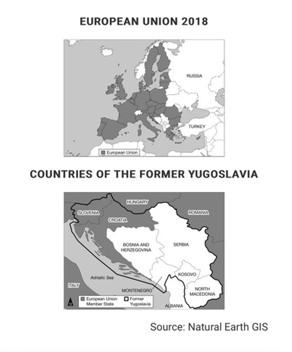
Examining the countries shown in white on the map of the former Yugoslavia, which of the following explains why the area would be referred to as a shatterbelt region?
Responses
A
The countries comprise a strategically positioned area and have unstable national governments.
B
The countries have an open-border policy and have abolished all passport and customs controls along their shared political boundaries.
C
The countries comprise a multiethnic culture region and have strong federal governments.
D
The countries are outside of the European Union but are inside of the European continent.
E
The countries are former communist states and remain allied with the Russia.
The countries comprise a strategically positioned area and have unstable national governments.
The map above shows the countries in Africa where private investors and foreign governments have leased farmland for large-scale commercial farming. Usually much of the food produced is bound for wealthier nations.
This practice is an example of
Responses
A
decolonization
B
Pan-Africanism
C
neocolonialism
D
imperialism
E
irredentism
neocolonialism
The provisions of the United Nations Conference on the Law of the Sea give coastal countries navigational and economic sovereignty over which of the following zones?
Responses
A
Twelve-nautical-mile territorial sea zone
B
Export processing zone (EPZ)
C
200-nautical-mile exclusive economic zone
D
Empowerment zone
E
Continental shelf
Twelve-nautical-mile territorial sea zone
Which of the following countries did NOT have a significant, long-lasting colonial presence in Africa after 1920 ?
Responses
A
Germany
B
Great Britain
C
France
D
Portugal
E
Belgium
A
Germany
Compare the centralized power of the Soviet Union with the contemporary Russian Federation, in terms of the control of territory. Which of the following statements does the information in the map best support?
Responses
A
Russia is a global power with concentrated power in East Asia.
B
Russia is a multistate nation made up of numerous sovereign independent entities.
C
Russia's autonomous regions illustrate a strategy to counter the difficulty in governing such a large area from a single centralized location.
D
Russia is an ethnically diverse region with many subnational units.
E
Russia used to control fifteen additional republics that regained their independence in 1990.
D
Russia is an ethnically diverse region with many subnational units.
Which of the following terms best describes the political entity of the Republic of Ireland?
Responses
A
Stateless nation
B
Multinational state
C
Nation-state
D
Autonomous region
E
Dependent territory
C
Nation-state
The shape of North Carolina's Twelfth Congressional District, shown above, is most likely the result of
Responses
A
watershed boundaries
B
gerrymandering
C
county boundaries
D
decentralization
E
amalgamation
B
gerrymandering
Owing to their localized geography or their locations on islands or peninsulas, many small political entities such as those labeled on the political map of the world can be identified as
Responses
A
federal states
B
autonomous republics
C
multistate nations
D
nation-states
E
colonial territories
D
nation-states
What do the states represented above have in common? (Picture shows different countries split into regions)
Responses
A
They are all federal states.
B
They are all formerly communist states.
C
They are all mega states.
D
They are all unitary states.
E
They are all ethnic states.
They are all federal states.
The Berlin Conference of 1884-1885 and the partition of India in 1947 changed borders in Africa and South Asia and are reflected in the current world map. Which of the following best describes the type of political border resulting from these events?
Responses
A
Relict boundaries
B
Antecedent boundaries
C
Consequent boundaries
D
Superimposed boundaries
E
Subsequent boundaries
Superimposed boundaries
Which of the following is an example of a supranational organization with the main mission of increasing economic integration?
Responses
A
The North Atlantic Treaty Organization
B
The European Union
C
The United Nations
D
The International Red Cross and Red Crescent Movement
E
The United States Federal Reserve
B
The European Union
The Berlin Wall fell in 1989, but people in the former East and West Germany still feel its influence. Geographers would say that where the wall once stood now acts as a
Responses
A
superimposed boundary
B
relict boundary
C
fortified boundary
D
antecedent boundary
E
natural boundary
relict boundary
Which of the following is NOT part of the definition of a state?
Responses
A
A common language
B
An organized economy and circulation system
C
Political sovereignty
D
A permanent resident population
E
Defined boundaries
A common language
The European Union, the Arab League, and the United Nations are all examples of
Responses
A
pressure groups
B
nation-states
C
centrifugal organizations
D
supranational organizations
E
federations
supranational organizations
The European Union is an example of
Responses
A
supranationalism
B
nationalism
C
a fragmented state
D
a unitary state
E
a nation-state
supranationalism
Which of the following events could be a threat to a state's sovereignty at the national scale, while holding a region together at the global scale?
Responses
A
A natural disaster such as an earthquake or tsunami occurring within the country
B
A member of the state's minority political party being elected to lead the country
C
Admittance into a supranational organization such as the European Union
D
Decommitment to environmental resolutions established by the United Nations
E
A shift from a federal system to a unitary system of governance within the state
Admittance into a supranational organization such as the European Union
Which of the following best explains the political pattern shown in the table?
Responses
A
The devolution of Yugoslavia occurred primarily along national lines, resulting in countries with a defined ethnic majority.
B
The breakup of Yugoslavia was the result of a civil war in which ethnic groups fought for control of the capital of Belgrade in Serbia.
C
The Balkanization of Yugoslavia resulted in the formation of new ethnic nationalities divided by differences in religion and language.
D
The dissolution of Yugoslavia resulted in some ethnic groups being aligned with capitalist Western Europe and others being aligned with communist Eastern Europe.
E
The downfall of Yugoslavia was a case of ethnic differences becoming a centripetal force in the formation of a multistate nation.
The devolution of Yugoslavia occurred primarily along national lines, resulting in countries with a defined ethnic majority.
Which of the following describes a federal form of governance?
Responses
A
A centralized government creates a barrier to local participation in the political process.
B
Autonomous regions act outside the authority of a central government.
C
Federal states encourage devolutionary movements and break apart quickly.
D
Laws are enacted in a single language to promote cultural unity.
E
Multiple substates have local control and are unified to pursue common goals at the national level.
E
Multiple substates have local control and are unified to pursue common goals at the national level.
Which of the following describes a unitary form of governance?
Responses
A
Stronger states and transnational corporations indirectly control weaker states.
B
A state has a strong central government with no power given to regions.
C
A collection of independent communities shares government services.
D
A state's more powerful central government shares power with its regions.
E
A sense of unity, often derived from ethnic or cultural traits, binds a country together.
A state has a strong central government with no power given to regions.
Which of the following is an accurate comparison of devolutionary movements in Spain and Canada?
Responses
A
There is an economic aspect to the Quebecois independence movement, while the Catalans focus mainly on culture.
B
Both independence movements utilize cultural distinctiveness as their only reason for seeking independence.
C
Both independence movements focus on religious differences with the nations they currently belong to.
D
There is an economic aspect to the Catalan independence movement, while the Quebecois focus mainly on cultural differences.
E
Both independence movements utilize economic power as their main reason for seeking independence.
There is an economic aspect to the Catalan independence movement, while the Quebecois focus mainly on cultural differences.
Based on the data in the table, which of the following is a possible impact of ethnic and religious diversity in Iraq?
Responses
A
Ethnicity and religion act as centripetal forces in the country by creating a common Iraqi identity among the population.
B
Ethnicity and religion facilitate democratization in the country by motivating participation in elections.
C
Ethnicity and religion promote economic development in the country by generating national pride in the country's accomplishments.
D
Ethnicity and religion lead to devolutionary pressures in the country by politically dividing regions.
E
Ethnicity and religion increase cultural cohesion in the country by promoting shared political ideology.
Ethnicity and religion lead to devolutionary pressures in the country by politically dividing regions.
Which of the following can be an example of a centrifugal political force?
Responses
A
Homogeneous ethnic population
B
Strong central government
C
Variation of language within the country
D
Shift to tertiary economy
E
Concentrated ownership of media
Variation of language within the country
Which of the following describes an example of a consequent boundary?
Responses
A
The Berlin Wall between East and West Germany no longer exists, but the location is still evident.
B
European powers divided Africa at the Berlin Conference and drew boundaries across the continent.
C
The United States-Canadian boundary was set at the 49th parallel by a treaty before the area was settled.
D
Canada created the province of Nunavut to provide greater autonomy for the First Nations.
E
The Andes Mountains are used as a political boundary to divide Chile and Argentina.
Canada created the province of Nunavut to provide greater autonomy for the First Nations.
Which of the following best explains the governance of the shaded areas shown on the map?
Responses
A
These areas are established as nation-states for indigenous peoples at the local scale.
B
These areas show territory occupied by indigenous peoples as stateless nations at a local scale.
C
These areas show territory controlled by indigenous peoples as a single multistate nation.
D
These areas show where indigenous peoples have a limited amount of self-government at a national scale.
E
These areas are lands of indigenous peoples that are sovereign independent states at an international scale.
These areas show where indigenous peoples have a limited amount of self-government at a national scale.
Crossing which of the following borders requires few, if any, formalities and thus encourages the free flow of people and products?
Responses
A
Netherlands-Belgium
B
India-Pakistan
C
United States-Canada
D
Romania-Ukraine
E
North Korea-South Korea
Netherlands-Belgium
Which of the following best explains the effect of French language and culture on the federal state of Canada's political power?
A
French lang and culture act as a centripetal force throughout Canada as the majority of Canadians have English as a first language and the government uses both languages in official communications.
BAs an expression of political power, the Canadian federal government restricts French language and culture from media and government proceedings.
CFrench lang and culture act as centripetal forces and unify all of Canada's people and government into a single nation.
DFrench lang and culture act as a centrifugal force in Canada because independence movements in Quebec have attempted to secede the province from Canada.
EBecause French Canadians are spread across the country's provinces, the Canadian government implemented federal laws to create a common culture and language for all Canadians.
French language and culture act as a centrifugal force in Canada because independence movements in Quebec have attempted to secede the province from Canada.
What is the source of dispute between Canada, Russia, Norway, Denmark, and the United States over political boundaries in the Arctic Ocean and ownership of the North Pole?
Responses
A
They all claim the right to extract natural resources out to the edge of the continental shelf, beyond their exclusive economic zones.
B
They all claim to have had indigenous residents from their countries living on the polar ice pack at sometime in the past.
C
Each claims the first explorer to reach the North Pole came from their country and planted their flag, signifying ownership.
D
The northern polar region has the same international treaties that govern land use and resources in Antarctica.
E
The North Pole is the focal point of all the intersecting boundaries on the map. However, it floats on a constantly moving ice sheet.
They all claim the right to extract natural resources out to the edge of the continental shelf, beyond their exclusive economic zones.
Which of the following terms refers to an area of instability located between regions with opposing political and cultural values?
Responses
A
Rimland
B
Heartland
C
Shatter belt
D
Enclave
E
Gerrymandered area
C
Shatter belt
FLIP
Most areas with a Kurdish majority population are landlocked and therefore dependent on good relationships with their neighbors in order to access trade and prosper economically.
Based on the map, which of the following best explains the implications of physical geography as the Kurds continue to struggle for an independent state in their ethnic homeland?
Responses
A
Israel, Turkey, and Russia have voiced their support for an independent Kurdistan in areas with a majority Kurdish population, showing potential validation for Kurdistan.
B
In September 2017 a public referendum was carried out that demonstrated that a majority of Kurds overwhelmingly support independence.
C
Most areas with a Kurdish majority population are landlocked and therefore dependent on good relationships with their neighbors in order to access trade and prosper economically.
D
Even in areas with a Kurdish minority population, Kurdish people have their own unique culture and identity separately from the states in which their nation is located.
E
Unstable oil prices have created economic problems both in parts of the region with a Kurdish majority population and in parts with a Kurdish minority, leaving the Kurdistan Regional Government weakened and struggling to pay off debt.
Most of Africa's political boundaries were originally drawn by
Responses
A
seventeenth-century European explorers
B
European colonial powers in the late-nineteenth century
C
the Bandung Conference of 1955
D
decolonization movements of the 1950s and 1960s
E
UN peacekeeping missions in the 1950s and 1960s
European colonial powers in the late-nineteenth century
Which of the following is the name for political redistricting that produces unusually shaped districts to create a political advantage?
Responses
A
Gerrymandering
B
Redlining
C
Zoning
D
Politicization
E
Gentrification
Gerrymandering
United Nations recognition of a state's "exclusive economic zone" allows the state to
Responses
A
establish economic free trade zones within the sovereign territory of other states
B
claim national economic jurisdiction over 200 nautical miles of water extending from its coast
C
limit importation of competitive goods and services from other countries
D
protect domestic production by imposing tariffs on all foreign-made products
E
form limited economic alliances with other countries
claim national economic jurisdiction over 200 nautical miles of water extending from its coast
Which of the following possible political effects is implied by the data in the table?
Responses
A
The country's high level of economic development acts as a centripetal force holding the state together.
B
The high level of economic difference between the regions in Italy acts as a devolutionary force.
C
The low level of economic difference between regions in Italy acts as a centripetal force holding the state together.
D
The low level of economic difference between regions in Italy promotes devolutionary movements in some parts of Italy.
E
The country's low level of economic development promotes centrifugal forces tearing the state apart.
The high level of economic difference between the regions in Italy acts as a devolutionary force.
FLIP
The Kurdish people, seeking a state of their own with a majority Kurdish population, might secede from or rebel against the states labeled on the map.
Based on the information in the map, what is the most likely outcome of the possible establishment of an independent Kurdistan for the Kurdish people?
Responses
A
The state of Turkey, seeking to connect areas with a substantial Kurdish population into an independent state, might take action against neighboring states.
B
The Kurdish people, seeking a state of their own with a majority Kurdish population, might secede from or rebel against the states labeled on the map.
C
The Kurdish people would have to migrate into a single country to gain a population majority and would struggle for control of the government.
D
In areas with a Kurdish majority population, Kurdish people are politically active among Turks, Iranians, Iraqis, and Syrians and would be able to win an election on a national vote to secede.
E
The countries shown on the map will cooperate and work together to address the political situation and needs of people in areas with a substantial Kurdish population.
Which of the following is South Africa's former state-sanctioned policy of segregating the races?
Responses
A
Redlining
B
Gerrymandering
C
Apartheid
D
Secularism
E
Gentrification
Apartheid