7. Sea level change + emergent/submergent landforms
1/12
There's no tags or description
Looks like no tags are added yet.
Name | Mastery | Learn | Test | Matching | Spaced | Call with Kai |
|---|
No analytics yet
Send a link to your students to track their progress
13 Terms
Describe both eustatic and isostatic change?
1. Eustatic change is the global change in sea level due to rises in global sea level
2. Isostatic change/readjustment is the rise and fall of land in relation to a given sea level
What happens when the climate gets colder/warmer?
Colder (glacial period) → increased precipitation as snow turns to glacier ice which act as a store for water slowing the hydrological cycle → less water returning to the sea → eustatic fall -> isostatic sinking of land due to ice weighing land down also creation of emergent features (however it is only on some coastlines)
Warmer → ice masses begin to melt → sea level rise (eustatic rise) → floods land creating submergent features like rias and fjords → as ice is removed from areas isostatic readjustment occurs. If it is faster than eustatic change then emergent features are creates like raised beaches
How could tectonic processes cause isostatic change?
- with volcanoes such as in Naple's Italy the magma chamber could fill causing an uplift of land which counteracts sea level rise
- continental collision also has this effect eg: Himilayers as it makes more space for the water
- Boxing day earthquake in India caused a tsunami and raised the seabed which reduced the capacity of the ocean producing a permanent rise in sea level
How does global warming effect the sea and land levels? Especially in the UK since the last ice age?
Causes ice to melt causing eustatic rise and isostatic readjustment.
The steric effect (thermal expansion) accounts for 20% of sea level rise between 1905 and 2005 and is where when the temperature is warmer the water particles get bigger.
Since the last ice age more Northern parts of the UK have experienced uplift due to no glaciers but gradual subsistence occurred in the South East → salination of freshwater rivers impacting irrigation
What is an emergent landform created by?
Fall in sea level or uplift in land, when the land is rising faster than the sea you get relict features
Describe and explain the formation/definition of a raised beach, arches, stacks, caves and cliff? What is my example?
Raised beaches are above high tide, flat + covered by sand/pebbles and experience succession
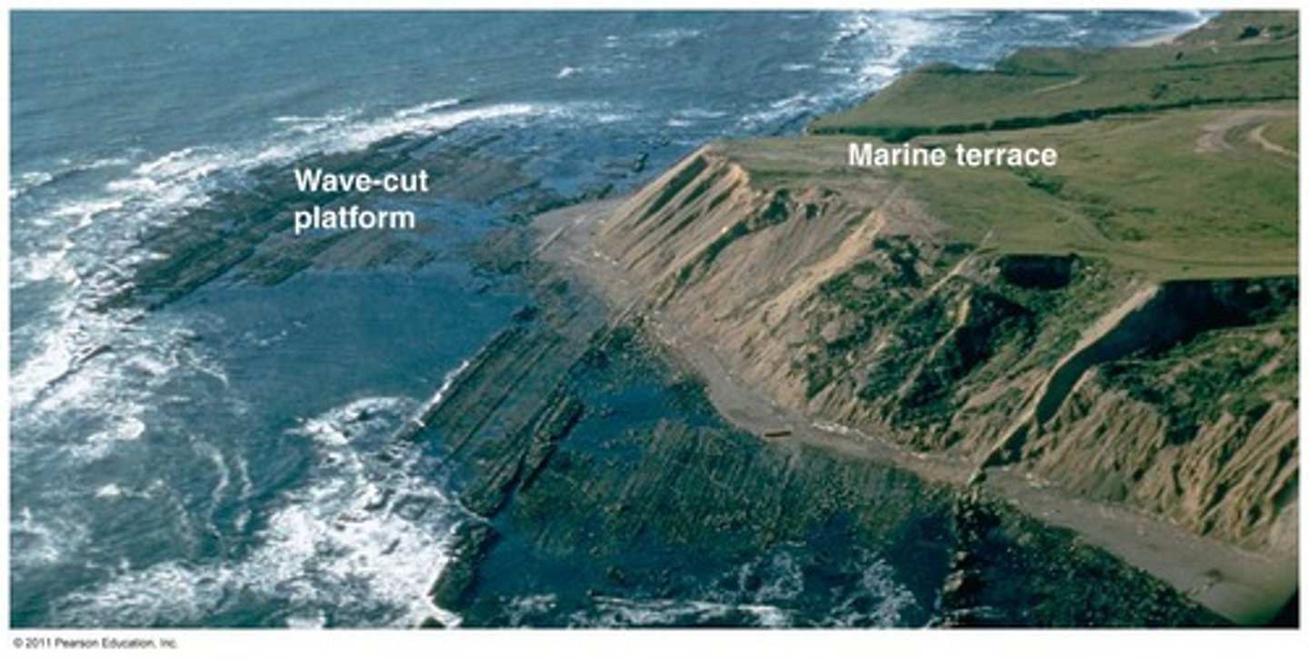
Marine platforms are areas which had former wave-cut platforms and their beaches generally they have relict arches, caves etc around them. They usually have 3 levels at 8, 15, 30m.
pebbles have been rounded already by wave action and fossilised remains of sea creatures
eg: West of Isle of Arran, Scotland
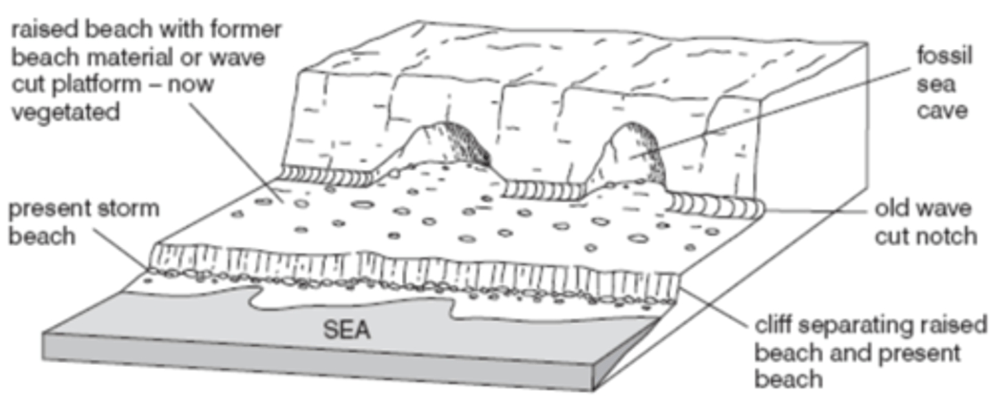
What is the difference between a marine platform and a raised beach?
Marine platforms are generally gently sloping inland for some distance. Marine platforms also are generally erosional material such as rocks whereas raised beaches are more depositional material like sand
What is a submergent landform and how do they form?
They form when the rise in sea level takes place faster than the isostatic rebound after a glacial period causing rising water to flood lower lying ground
What is a ria and how is it formed?
Rias are formed by rising sea levels drowning rivers valleys causing the floodplain of the river to vanish beneath rising waters eg: Kingsbridge Estuary, South Devon.
Describe the typical cross-section of a ria?
They generally have shallow water at their mouth which becomes deeper towards the middle of the river, exposed valley sides are gently sloping. Smooth profile getting deeper and reflect the original route of the river (windy) and its valleys before it was drowned. Often have a dendritic drainage pattern
What is a fjord, where are they generally found and how are they formed?
Fjords are drowned glacial valleys mostly found in New Zealand. Glaciers carved out the landscape creating glacial troughs due to glacial erosion and the sea drowned the troughs due to sea level rise eg: abrasion and plucking
Describe the typical cross section of a fjord?
They have steep valley sides which are straight and narrow and a U-shaped cross section.
They have a shallow end at the seaward end known as the threshold and small islands known as skerries there.
Straighter channels due to the erosive power of the glaciers removing the interlocking spurs → truncated spurs
What is a dalmation coast and how is it formed? Where are they found?
These are only on concordant coastlines and are small islands parallel to the coast. They start off as longitudinal valleys and due to rising sea levels they are flooded and submerged. They are found offshore and create long narrow inlets parallel to the coast. Mainly found in Croatia