Unit 5 Exam- AP Human Geography
1/38
There's no tags or description
Looks like no tags are added yet.
Name | Mastery | Learn | Test | Matching | Spaced |
|---|
No study sessions yet.
39 Terms
Sheep production in New Zealand and poultry production in Arkansas produce food animals for human consumption. Which of the following best describes the differences in the agricultural practices and land use for these products?
C) Sheep production is an example of extensive agriculture requiring large pastures, whereas poultry production is an example of intensive agriculture often practiced indoors.
In which of the following world regions has the Green Revolution had the least impact on agriculture?
E) Sub-Saharan Africa
Isolated farmsteads in the United States evolved as a result of all of the following EXCEPT
E) Physical barriers preventing communal farm practices
In 2017 the Ivory Coast exported $5.6 billion worth of cocoa beans and cocoa-derived products, such as cocoa butter. This represented 55 percent of the country's exports and was worth four times the country's combined gold and oil exports in that year. Which of the following best explains the international trade economy of the Ivory Coast?
B) High level of dependency on a single agricultural commodity that increases national economic risks during times of global economic crisis
Traditional labor-intensive agriculture often involves which of the following?
A) Field terracing
Labor-intensive intertillage is often practiced in...
B) Southeast Asia
Land parcels in the American Midwest tend to be rectilinear because...
A) The federal survey system adopted in the late eighteenth century imposed a geometric pattern on the landscape.
The growth potential of alternative agricultural practices such as the growing of amaranth grain and the raising of deer, elk, emus, and buffalo for meat is limited because...
B) The growers have not established an integrated commodity chain
Nomadic pastoralism is an extensive agricultural system practiced...
A) In the dry regions of Africa and Asia
On the map above, the shaded area is most associated with which of the following types of agriculture? (This one has a image)
D) Rice cultivation
Which of the following activities is most likely to be found in the outermost zone of von Thünen's model of agricultural land use?
E) Extensive grain or stock raising
Which of the following best explains the diffusion of plants and animals from their hearths of domestication?
C) Both domesticated plants and animals spread across the globe through contagious diffusion in early years by farmers and traders, and later by relocation diffusion through European exploration and colonialism.
Which of the following explains the diffusion and successful cultivation of many plants and animals in new regions of the world through the Columbian Exchange?
B) The plants and animals diffused to a region with climate and geography similar to that of their point of domestication.
Which of the following best explains a neo-Malthusian perspective on the Green Revolution?
A) The Green Revolution represents a jump in agricultural technology, but population will still grow faster than our ability to produce food will over the long run.
Which of the following best explains why the New England region, located in the northeastern United States, would specialize in market gardening agriculture rather than other types of agriculture, such as grain farming?
E) Several large cities on the East Coast provide a growing market and shorter distances for transporting market gardening products.
Traditionally, the Ganges Valley and the Nile Valley have had comparatively high population densities because of their...
D) Intensive agriculture based on irrigation
Women played a crucial role in the domestication of plants because they...
B) Were engaged in collecting plant resources
Which of the following best explains the reasons for the similarities and differences between the two land survey systems shown? (This one has a picture)
B) Both systems require geometric calculations to survey property lines. However, the township-and-range system uses simplified calculation to create a more ordered landscape.
Which of the following best explains the differences between the patterns of land use in the township-and-range system and the long-lot system, as shown in the images? (This one has a picture)
E) The township-and-range survey system was based on a geometric grid pattern, while the long-lot system was a rectilinear pattern based upon waterways or roads.
The two images represent different agricultural land survey patterns. Comparing the two images, which survey system was more efficient in terms of trade? (This one has a picture)
A) The river in the long lot survey system provided better access to waterways to transport goods to market.
The two images show different agricultural methods. In the context of the Second Agricultural Revolution, which of the following trends is represented in these images? (This one has a picture)
D) The mechanization of farming in the Second Agricultural Revolution resulted in more reliable crop harvests and healthier populations in areas where the mechanization was adopted.
The images shown illustrate a change that took place as the Second Agricultural Revolution coincided with the Industrial Revolution. Which of the following compares this geographic relationship between these revolutions? (This one has a picture)
D) The mechanization of farm work allowed many young people to migrate and join a growing urban industrial workforce.
The images show devices developed during the Second Agricultural Revolution. Which of the following best describes the impacts of the Second Agricultural Revolution? (This one has a picture)
Technological innovations, such as the devices shown in the images, and increased agricultural productivity led to better diets, longer life expectancies, and more people available for work in factories.

Which of the following is a characteristic of shifting cultivation?
E) Multicropping
Which of the following is an explanation for the similar impact of large-scale commercial agriculture in developed countries and plantation agriculture in developing countries?
B) Both farming practices involve the consolidation of family farms and displacement of rural communities.
Which of the following explains the role of commodity chains in the average size of farms?
C) Commodity chains have led to changes in the spatial organization of agriculture from dispersed family farms to large corporate farms that produce, process, and distribute the products.
Subsistence agriculture is most common in which of the following regions?
C) Amazon Basin
Which of the following is a subsistence crop?
A) Corn
In the South Asian country of Sri Lanka, tea is farmed as a monoculture. Which of the following best explains why tea plantations are common in Sri Lanka and tea exports are important to the country's economy?
E) Tea plantations were established in Sri Lanka by a former European colonial power.
The clearing of tropical rain forest for agriculture frequently results in...
B) A shift to animal raising
The above map shows von Thünen's model applied to a map of the contiguous United States. Which of the following realities would NOT be accounted for by the theoretical predictions shown on the map? (This one has a picture)
D) Florida's government has a Department of Citrus.
The township and range land survey system in the United States contributed to which of the following?
A) A dispersed rural settlement pattern
Why is the traditional classification of agriculture as a primary economic activity a problem when considering the geography of agriculture?
A) Modern farmers are engaged in production, research, marketing, and some manufacturing of their products.
Which of the following statements best describes the impact of improvements in transportation systems on agriculture?
C) Corporate farms have gained a greater advantage over family farms.
Which of the following social or environmental impacts is most directly related to the use of chemicals in agriculture?
E) An increase in land and water pollution from agricultural runoff
Compare the two maps and examine the data for Africa, the Middle East, and South Asia. Which of the following statements is supported by the comparison of the two maps? (This one has a picture)
B) Many women in these regions work on farms and grow food for their families, but not all are paid to do this work.
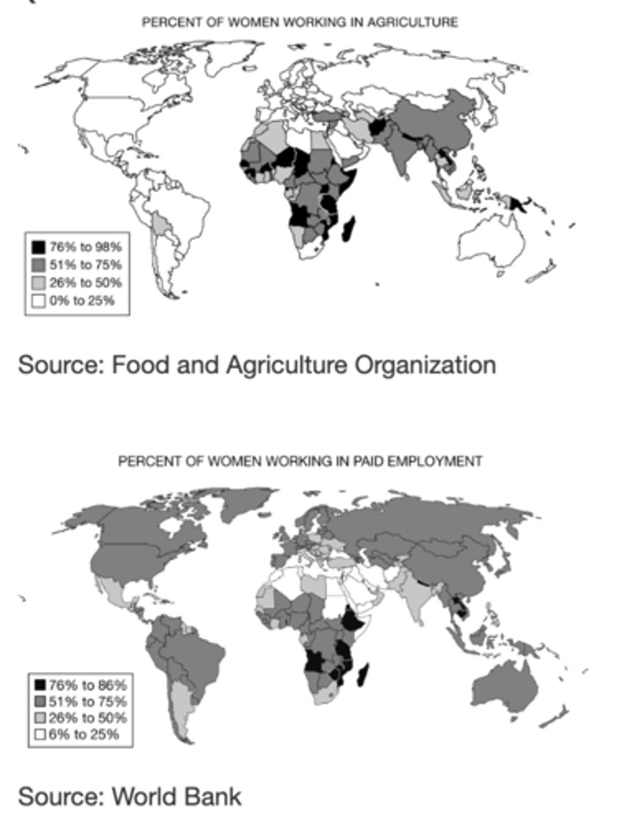
Which of the following explains the significance of the similarities between Asia and sub-Saharan Africa in terms of the percent of women working agriculture? (This one has a picture)
B) In the subsistence-based rural economies in these regions, female farmers produce much of the food that their families need for survival.
Which of the following best describes the roles of women in the rural, agricultural economies of sub-Saharan Africa?
B) Nonwage workers on small, family-run farms
Based on the map, which of the following explains the similarities of the world regions where at least 51 percent of women work in agriculture? (This one has a picture)
E) These regions are composed of less-developed countries with large rural populations.