EARTHQUAKES
1/19
There's no tags or description
Looks like no tags are added yet.
Name | Mastery | Learn | Test | Matching | Spaced |
|---|
No study sessions yet.
20 Terms
What Is an Earthquake?
An earthquake is the vibration of Earth produced by the rapid release of energy
•Energy released radiates in all directions from its source, the focus(single point)
•Energy is in the form of waves (move at diff speeds)
•Sensitive instruments around the world record the event
Causes of seismic motion
•Vertical displacements – faults; occur along zones of weakness in the crust.
•Large faults – like the San Andreas – large earthquakes.
•Small, discontinuous faults – small earthquakes.
Fault scarp, focus, epicenter
Fault scarp- one side moves up relative to the other.
Focus- where slip happens, and there’s a projection to the surface.
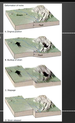
Movement along the fault but the “slip”, when it breaks, or bounce back can cause an earthquake. This “slip is elastic bounceback.
The focus is where the fault slips

Elastic Rebound
Deformation stores elastic energy
Frictional resistance is overcome
Slippage at weak point (focus)
Displacement creates stress farther along the fault where more slip will occur to release the built up strain.
Types of seismic waves
Body waves
•Travel through Earth’s interior
•Two types based on mode of travel
Primary (P) waves
•Push-pull (compress and expand) motion, changing the volume of the intervening material
•Travel through solids, liquids, and gases
→ move fast to the surface. compressional ways, moving up and down)
Secondary (S) waves
•“Shake” motion at right angles to their direction of travel
•Travel only through solids
•Slower velocity than P waves
→start and arrive later, move bottom to top like a tornado)
Surface waves
•Complex motion
•Cause greatest destruction
•Exhibit greatest amplitude and slowest velocity
→ most destructive, move like a jump rope, arrive the LATEST)
Locating an Earthquake (more info)
Epicenter is located using the difference in velocities of P and S waves
Locating the epicenter of an earthquake:
•Three station recordings are needed to locate an epicenter
•Each station determines the time interval between the arrival of the first P wave and the first S wave at their location
•A travel-time graph is used to determine each station’s distance to the epicenter
Seismometers are used to figure out distance from how far it is from earthquake
Locating an Earthquake
Locating the epicenter of an earthquake
•A circle with a radius equal to the distance to the epicenter is drawn around each station
•The point where all three circles intersect is the earthquake epicenter
Magnitude and Earthquake
The magnitude of an earthquake is the amount of energy that was released
Earthquake magnitude is quantified by Richer magnitude scale, Moment magnitude scale, Modified Mercalli intensity scale
Richter: good for small-moderate earthquakes
Moment: good for large areas and big earthquakes rather than a single point
Mercalli: correlates to the type of damage caused
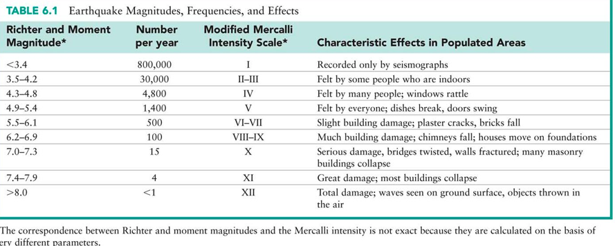
Earthquake Intensity Scale
Richter magnitude is calculated from the maximum recorded amplitudes of seismic waves with a correction for distance
→This means a seismograph at the epicenter would record the same magnitude as a seismograph hundreds of kilometers away
It is logarithmic, whereby each unit of increase corresponds to a 10-fold increase in wave amplitude, and a 32-fold increase in the amount of energy released
→Magnitude is on a scale where a small numeric jump equals a large physical jump: +1 magnitude → 10× bigger shaking and ~32× more energy
Seismic moment magnitude also measures energy released, however the calculation takes into account that the focus may be a large area rather than a localized point (more accurate)
e.g. the 2004 Sumatra-Andaman earthquake, in which a 1300 km length of the fault moved
The modified Mercalli intensity scale is based on the strength of vibrations that people feel and the extent of damage that occurs during the earthquake.
There is no correction for distance, so intensity near the epicenter would be very high, where hundreds of kilometers away it would be very low.
Earthquake Hazards Structure
Amount of structural damage attributable to earthquake vibrations depends on
•Intensity and duration of the vibrations
•Nature of the material upon which the structure rests
•Design of the structure (e.g. cali and japan need earthquake standards because of the frequent earthquakes)
Regions within 20 to 50 kilometers of the epicenter will experience about the same intensity of ground shaking
However, destruction varies considerably mainly due to the nature of the ground on which the structures are built
Earthquake Hazards Map
Have to relate earthquake hazards to where plate boundaries are.
Understanding the tectonic settings of earthquakes is of central importance when we quantify their hazards.
Most seismically active areas are located along plate boundaries
Sometimes there is strong earthquake activity far away from tectonic boundaries, those are instances of intraplate movement.
Earthquake Hazards Architecture
PRIMARY EFFECTS
→Ground motion can damage or destroy buildings
→Surface rupture occurs when the fault actually breaks ground surface, this can split buildings, disrupt roads, create an open fissure or a fault scarp
SECONDARY EFFECTS
→-Fires caused by displaced stoves, gas lines, wires, etc.
→Landslides may occur in sloped regions
→Liquefaction occurs with sudden disturbance of water-saturated soils (when water logged sediments shake and cause sediments to flow as if they were liquid)
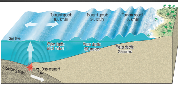
→Tsunami, a seismic sea wave, is initiated by sudden movement of the seafloor
Tsunamis
Tsunamis, or seismic sea waves
•Result from vertical displacement along a fault located on the ocean floor or a large undersea landslide triggered by an earthquake
•In the open ocean height is usually <1 meter
•In shallower coastal waters the water piles up to heights over 30 meters
•Long wavelength waves caused by vertical displacement along a fault on the ocean floor or from a large underwater landslide triggered by a volcano
Failure of formation above water, landmass falls into water causing for displacement to generate a long wave length in the ocean
Formation of a Tsunami
friction builds up and so elastic rebound occurs.
Causing a seismic wave to displace water; as large waves continues to roll along, it crops above the surface of the water
Magnitude 9.0 NEAR THE EAST COAST OF HONSHU, JAPAN
Japan was struck by a magnitude 9.0 earthquake off its northeastern coast Friday. This is one of the largest earthquakes that Japan has ever experienced.
In downtown Tokyo, large buildings shook violently and there is severe flooding due to a tsunami generated by the earthquake.
Part of houses swallowed by tsunami burn in Sendai, Miyagi Prefecture (state) after Japan was struck by a strong earthquake off its northeastern coast Friday, March 11, 2011.
Tsunami waves swept away houses and cars in northern Japan and pushed ships aground.
The tsunami waves traveled far inland, the wave of debris racing across the farmland, carrying boats and houses with it.
Houses were washed away by tsunami in Sendai, Miyagi Prefecture in eastern Japan, after Japan was struck by a magnitude 9.0 earthquake off the northeastern coast.
The Septentrional/Enriquillo-Plantain Garden Fault Zone
The Septentrional / Enriquillo–Plantain Garden fault system is the principal left‑lateral transform plate boundary that cuts across Hispaniola (and links westward into the Cayman Trench). It accommodates significant relative motion between the North American and Caribbean plates, so it is a primary source of large, destructive earthquakes in the region
Magnitude 5.8 VIRGINIA
This earthquake was felt along the east coast from South Carolina to Maine. Shaking was felt as far away as Atlanta, Detroit, Canada, to as far west as Indiana.
While earthquakes in the eastern United States are less frequent than in the western United States, they are typically felt over a much broader region. Often times, an earthquake can be felt over an area as much as ten times larger than a similar magnitude earthquake on the west coast. This is due to the ease of wave propagation through the North American Craton (a craton is an old and stable part of the continental lithosphere).
The North American Plate is moving away from the Mid-Atlantic Ridge toward the west-northwest. It is tempting to envision the west-northwest to east-southeast compression of the Atlantic Coast region as simply due to ridge push from the Mid-Atlantic Ridge.
However, this direction of compression is also approximately perpendicular to the Appalachian Mountains and may be related to those mountains that resulted from collision between North America and Africa about 300 million years ago.
As the Appalachian Mountains erode, the crust “rebounds” and flexes in a fashion that could contribute to stress within the Atlantic Coast region.
DIVERGENCE OF NORTH AMERICAN PLATE AWAY FROM EURASIAN AND AFRICAN PLATE
→ STRESS BUILDS UP AND RELEASED AS FAULT DEFORMATION AMNIFESTED AS AN EARTHQUAKE
Pangaea
In addition, there are many faults in this region inherited from the formation of the Appalachians and the rifting of North America from Africa during the subsequent breakup of Pangaea about 200 million years ago.
These old faults can be reactivated by stresses of ridge push or other origins and result in occasional earthquakes in the Atlantic Coast region.
At well-studied plate boundaries like the San Andreas fault system in California, often scientists can determine the name of the specific fault that is responsible for an earthquake. In contrast, east of
the Rocky Mountains this is rarely the case. The Central Virginia Seismic Zone is far from the nearest plate boundaries, which are in the center of the Atlantic Ocean and in the Caribbean Sea. The seismic zone is laced with known faults but numerous smaller or deeply buried faults remain undetected. Even the known faults are poorly located at earthquake depths. Accordingly, few, if any, earthquakes in the seismic zone can be linked to named faults. It is difficult to determine if a known fault is still active and could slip and cause an earthquake. As in most other areas east of the Rockies, the best guide to earthquake hazards in the seismic zone is the earthquakes themselves
→origin of some faults are due to Pangaea. faults are some areas of weaknesses that correspond to collision events that formed Alps.
→ also weak spots for divergence to occur.
CN: Info about Faults
Fault in the dips of the Earth.
→more weathering
→ where water moves down and sediments disappear
CN: Earthquakes and Liquification
Earthquakes can cause for liquification (big debris flow)
Liquefaction is when shaking turns water‑logged soil temporarily liquid; that liquid soil can flow like a powerful debris mass, causing major damage during earthquakes