Exam 2 - Hazards and Disasters
1/43
There's no tags or description
Looks like no tags are added yet.
Name | Mastery | Learn | Test | Matching | Spaced | Call with Kai |
|---|
No analytics yet
Send a link to your students to track their progress
44 Terms
What is a tsunami?
A series of waves resulting from a rapid and large-scale displacement of a deep-water column occurs.
How do tsunamis differ between the open ocean and coastal zones?
Open ocean tsunamis:
These open ocean tsunamis originate from an earthquake epicenter
The wave heights on open ocean tsunamis are usually less than 3 feet
They move very fast (200 mph)
Not dangerous out in the open ocean
Requires many hours to cross the large open oceans before hitting land
Coastal tsunamis:
After propagating the waves slow down and grow in height (20-150 ft. at coastline)
What is the difference between run-up and inundation and what are their related factors?
Run-up:
The maximum wave height observed at the coastline
Related Factors:
coastal configuration
offshore topography
Inundation:
The maximum inland reach of the wave.
Related Factors:
onshore topography
obstacles in the wave’s path
What are the four causes of tsunamis, and the percentage of tsunamis caused by each type?
Earthquake Tsunami (80%)
Landslide Tsunami (about 15 percent are underwater landslides)
Volcano Tsunami (5%)
Falling Meteorite Tsunami (Prehistoric occurrence)
What is the spatial distribution of tsunami risk?
Greatest Hazard:
The Ring of Fire,
The western coast of South America
Japan
Philippines
New Zealand
Hawaii
The western coast of Alaska
Significant hazard:
Southern Italy
Greece
Part of the western Alaskan coast
Low hazard:
The East coast of the United States
The northern tip of South America
The eastern coast of China
What are the primary monitoring methods of tsunamis?
The two main methods employed by the Pacific Tsunami Warning Center in Hawaii provides global monitoring of tsunamis through seismographic readings and the use of DART buoys.
Seismographs are employed to monitor earthquake activity in the open ocean and near the coast.
Deep Ocean Assessment and Reporting of Tsunamis (DART) buoys:
This is a network of over 100 buoys that is supported by over 20 countries
These buoys are put on shipping charts so they are not hit by boats carrying cargo
If the buoy quickly moves up and down, then you know that a fast-traveling wave has just gone by and is heading for land
These buoys are anchored to the ocean’s surface by a nylon rope or chain (with leeway so it can move)
They are also paired with a bottom pressure recorder on the ocean’s surface using acoustic telemetry (can monitor the pressure associated with fast-moving tsunami waves)
They transmit this data to a collection satellite and back to the tsunami warning center (wherever they are)
What is the range of alerts that the Pacific Tsunami Warning Center issues?
Information Statement (no action needed)
Watch (be prepared to take action)
Advisory (stay away from the shore)
Warning (move inland to high ground)
What are the hazards and major impacts of tsunamis affecting coastal areas?
Major impacts near the coast:
Rapid coastal flooding
Damage to infrastructure
Considerable loss of life
Loss of livelihood (food/income)
Contaminated water supplies
Spread of diseases
Destruction of ecosystems (coastal ones such as barrier reefs, mangrove forests, etc.)
Explain the Hawaii Tsunami of 1946?
Cause: earthquake (M=8.1) up near Alaska
The wave reached Hawaii 4-5 hours later
Run-ups exceeded 40ft.
Over 160 deaths
Over 1000 structures destroyed (most of the damage was on the Big Island of Hawaii)
This tsunami in Hawaii is the deadliest in U.S. history
We had no good way to communicate the occurrence of earthquakes and tsunamis at this time, so there was little warning
Mitigation Lessons:
The Pacific Tsunami Warning Center was established after this event (1949)
Explain the Prince William Sound (Alaska) Tsunami of 1964.
This tsunami was created by an earthquake resulting from a massive underwater landslide
A strong earthquake (M=9.2) produced this underwater landslide that spread across the Pacific Ocean
The run-up (maximum wave height) exceeded 100 ft. in Alaska
The run-up exceeded 20 ft in California (steep coastline)
Over 300 million in damage (2nd worst tsunami in U.S. History)
Over 120 deaths
Massive destruction on the coast/not so much damage inland
Explain the Indian Ocean Tsunami of 2004.
Cause:
Strong underwater earthquake (M=9.2) near Sumatra (there were also many aftershocks of M > 8.0)
The tsunami reached Sumatra, Indonesia in 10 minutes (very fast)
This was especially dangerous considering people had tried to take shelter from the earthquake, and then had to worry about a tsunami quickly after
It reached India/Sri Lanka in 90 minutes
The run-ups exceeded 50-100 ft.
The quick turnaround time and the lack of a warning system in the Indian Ocean at that time led to the high death toll
Over 250,000 deaths (in 11 countries)
Over 20 billion dollars in damage (probably an underestimate)
Example: Banda Aceh of Indonesia was unrecognizable, and the coastline was destroyed and submerged after the tsunami
It caused damage, death, and displacement in multiple countries
Indonesia
Somalia: 150 dead
Maldives: 82 dead
Seychelles: 3 dead
Sri Lanka: Over 30,000 dead
Thailand: 5000 dead, 3400 missing
India: 375,000 people displaced
Malaysia
Danger: There was no warning system in the Indian Ocean at the time!!
Explain the tsunami that affected Tohoku, Japan in 2011?
A strong underwater earthquake (M = 9.1) roughly 70 km east of Tohoku, Japan
A warning was issued 3 min after the earthquake
The tsunami reached Tohoku in 10 minutes (so not enough time to react)
The run-ups exceeded 40 ft.
Inundation reached 6 miles inland
Damages:
Over 20,000 deaths
Over 300 billion dollars in damage
The Fukushima nuclear plant was damaged
Explain the hypothetical tsunami that could affect the Canary Islands?
Any strong eruption (VEI > 5.0) of the Cumbre Vieja volcano is expected to trigger massive crater wall collapse (landslide) into the Atlantic Ocean, and cause a “mega-tsunami”
The west side of this crater could fall into the ocean during an eruption and impact all the cities living near the volcano, and create a massive tsunami
The concern is that this will happen within our lifetime and cause a tsunami on the West Coast
There is no official Atlantic Ocean tsunami warning center, but the Pacific one is doing some monitoring in the ocean
What are the four most common mitigation methods to lessen the impacts of future tsunamis?
Early detection/warning systems:
Tsunami warning centers
DART buoys
Detailed analysis of past tsunamis:
Understand how the above-water and below water topography affects the tsunami and its run-ups
You can create location-specific run-up maps using models to simulate a range of possible events
This can give people an idea of how far to travel to save themselves
Coastal planning:
Structures (seawalls)
Popular in Japan (they have the world’s tallest seawall; however, waves have gone over it before)
Evacuation zones
Education:
Tsunami identification classes
Annual “tsunami days.”
Household preparedness
What is the basic definition of a mass movement?
A downslope movement of material due to gravity.
What are the common triggering mechanisms for a mass movement?
Weathering / Erosion
The weathering and erosion of rocks and soil can lead to weaknesses in the slope, weaknesses in a ridge that can create a mass movement or a landslide.
Water / Heavy Precipitation
The fall and subsequent freeze of water that is within soil or within rocks can actually weaken them or crack the rocks and particularly lead to rock falls, which can then trigger larger mass movements.
Temperature variations
If the temperature varies across the freezing mark for water it can lead to cracks in the rock and larger mass movements.
Loss of vegetation
Loss of roots that hold the soil together
Human modifications
Earthquakes/ Volcanoes (lahars)
What are the basic types of mass movements?
Falls (happen on steeper slopes):
Rock fall
Debris fall
2. Slides (happen on shallower slopes):
Rockslide
Debris slide
Slump
3. Flows (water + debris):
Rock avalanche
Debris avalanche
Mudflow
Earthflow
Debris flow
Earth creep
Solifluction
Snow avalanche **
What is the definition of rock/debris falls and what are the common causes?
Definition: The free fall of earth material through the air to a lower elevation
Causes:
Water freeze-thaw
Earthquakes
What is the definition of rock/debris/slump slides and what are the common causes of them?
Definition: the movement of earth material as a coherent body down a slope
Causes:
Heavy Precipitation
Weathering / Erosion
Earthquakes
What is the difference between a translational slide and a rotational slide?
A translational slide is when material moves along a slip plane with a constant slope gradient.
Whereas a rotational slide is when material moves along a slip pane with a curved slope gradient.
What is the definition of rock/debris/mud flows and what are the common causes of rock/debris/mud flows?
Definition: The movement of material as a turbulent fluid down a slope (often following the local drainage basing channels)
Causes:
heavy precipitation,
snowmelt
volcanic eruption
How do creep and solifluction flows differ from rock/debris/mud flows?
Creep/solifluction flows are the slow movement of earth material down a slope while rock/debris/mud flows are the fast movement of solely wet materials down a slope.
What is the definition of snow avalanches and what are the common causes of snow avalanches?
Definition: the movement of frozen water material (snow or ice) down a slope
Causes:
heavy snowfalls
daily temperature variations
What is the difference between a powder avalanche and a slab avalanche?
A powder avalanche is made of loose, fine-grained snow and these avalanches are most common in the winter season after a heavy snowfall.
In contrast, a slab avalanche is the movement of coherent blocks of snow/ice and this mass movement is most common in the spring season during the rapid freeze-and-thaw cycles.
What is the spatial distribution of mass movement risk?
Global Spatial Distribution:
The western mountains of the US,
The Andes,
The volcanic mountains in:
Carribean and Central America
The Tibetan Plateau
U.S. Spatial Distribution:
The Rocky Mountains
The Appalachian Mountains
What are the primary monitoring methods for landslides?
The USGS Landslides Hazard Program monitors:
Surveys of rock/soil types (field / GIS)
Precipitation (weather stations / radar)
Soil Moisture (bore hole sensors)
Slope movement (GPS / satellites)
Earthquake activity (seismometers)
Warnings
• Mostly site specific
• USGS and NOAA will issue general
advisories during heavy rain events
(e.g., Hurricane Helene 2024)
What are the primary monitoring methods for snow avalanches?
The U.S. Avalanche Forecast Centers will monitor:
Historical avalanche surveys (GIS)
Snowfall (weather stations / radar)
Temperature / Wind (weather stations)
Snowpack slope stability (field tests)
This is when the field scientists go out and dig out layers to see if there is ice under the powdery snow that could cause snow avalanches.
Earthquake activity (seismometers)
Warnings
Mostly site specific
NOAA will issue general advisories
during major winter storm events
Expand on the details of the Oso Landslide of 2014.
Oso Landslide (2014):
Massive landslide of an unstable hillside adjacent to the Stillaguamish River in Washington State
The debris dammed up the river, and then the water went back upstream, leading to over 40 deaths
Over 50 structures were destroyed
The losses exceeded 60 million dollars
Considered the deadliest landslide in U.S. history
Post-event analysis:
The destabilization was due to extensive multi-year logging near the hilltop and hillside (loss of vegetation)
They logged the mature trees and the activity, despite the planting of more trees, led to the slope giving way
A combination of loss of vegetation and human modifications led to this landslide.
Explain the Montecito Mudslides of 2018.
They had had a lot of fires in Southern California due to a period of prolonged droughts
This leads to vegetation loss
Then along came heavy rainfall that led to massive landslides and mudflows in residential valleys after several days of this precipitation
It led to 20 deaths (150 hospitalized)
Over 500 homes destroyed/damaged
Losses: $200 million (+)
Costliest landslide in US history (could be less than the Helene damage)
Post-event analysis:
Extensive wildfires the month prior destabilized the ridgelines and slopes of the area
Triggers: loss of vegetation, heavy precipitation, human modifications
Explain the Hurricane Helene Landslides of 2024.
The hurricane’s crossing of the Southern Appalachians produced 10-30 inches of rainfall in a four-day period
There were over 2000 landslides and mudflows that swept through valleys, destroying and damaging homes, roads, and bridges
This led to widespread damage in western NC, Tennessee, etc.
Caused over 20 deaths (landslide-based)
Over 1000 homes were damaged/destroyed directly by landslides or mudslides
Losses:
No landslide-specific estimate (storm total exceeded 75 billion dollars)
Costliest landslide in U.S. History (estimates have not been fully compiled yet)
Explain the Mt. Everest avalanche of 2015.
A strong earthquake (M = 7.8) struck Nepal and the surrounding countries
Numerous avalanches and landslides were triggered throughout the region (including one near Mt. Everest)
The avalanche swept in from the left hillside after being triggered by the earthquake
This resulted in over 20 deaths (60+ injured)
Over 9000 deaths in all the places where avalanches and landslides were triggered
There was no Everest-specific estimate of economic loss
The total earthquake damage exceeded 10 billion dollars
What are the five most common mitigation methods to lessen the impacts of landslides?
Early detection/warning systems
Detailed analysis of past events
Artificial Release (explosive charges)
They do this through using artillery canyons to shoot shells up to a mountaintop where the possibility of avalanches is high (create small ones so you don’t get a big one)
Geotechnical Engineering:
Deflecting walls
Ex: Iceland (read the blue box!!!)
These are walls that push the snow into areas that do not contain humans (the ocean or otherwise)
Avalanche “sheds”
These are essentially tunnels that allow for cars and trains to pass through in the event that an avalanche occurs.
It allows the snow to just go over the tunnels instead of onto the road or tracks.
Snow fences
Allows snow to build up on a flat location instead of on a vertical slope
Vegetation
Education
Land-use planning
What are the six most common mitigation methods to lessen the impacts of snow avalanches?
Early detection/warning systems
USGS Landslides Hazards Programs
Pay attention to weather observations (heavy rainfall and snow events) and evacuate accordingly
Detailed analyses of past landslides using remote sensing and GIS
Geotechnical Engineering:
Slope supports (walls) - made of shockcrete (concrete)
Re-grading of slopes (reduce the verticality)
Installing slope drains
Vegetation
Education
Land-use planning
What is the definition of weather?
Weather: short term changes in atmospheric conditions (hours to weeks)
What is the primary reason for weather and the four causes behind that primary reason?
The primary reason for weather is the unequal heating of the surface of the earth.
What are the four causes behind the unequal heating of the surface?
The earth’s orbital tilt
The Earth’s axis is tilted 23.5 degrees from its orbital plane around the sun, and this tilt varies the spatial distribution of incoming radiation
Solar incidence angle
the maximum solar radiation occurs near 12 noon
the minimum solar radiation occurs at sunrise and sunset
Albedo
The degree of reflectivity of a surface
Specific heat
how resistant a material is to changes in temperature
Water has a high specific heat meaning it takes a high heat for it to warm up and then it cools slowly
Land has a low specific heat meaning it warms up and cools very quickly
In what layer of the atmosphere does weather occur?
Weather occurs in the troposphere.
How do air motions and clouds differ between regions of low pressure and high pressure?
In regions of high pressure: wind diverges at the surface so the air has to replace the diverging air so it sinks when the pressure is high and disperses clouds
In regions of low pressure: wind converges so the air is forced to rise as the gaps are filled, and this creates clouds, and precipitation
How does the pressure gradient force influence wind speed?
Air moves from H to L pressure (air flowing downhill - like a ball rolling down a hill)
• Steep gradient → strong winds
• Gradual gradient → weak winds
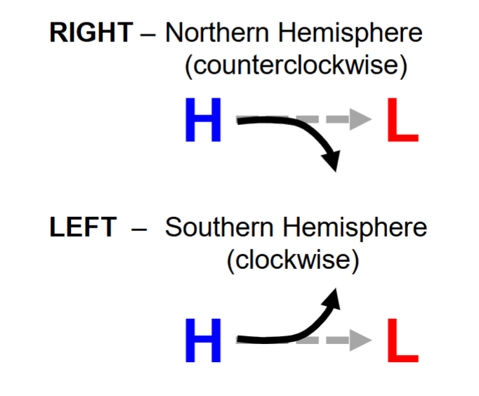
How does the Coriolis force influence wind direction?
The Coriolis effect makes it so that Earth’s rotation deflects moving air to the right or left depending on the hemisphere.
The air is deflected to the right in the Northern Hemisphere
The air is deflected to the left in the Southern Hemisphere
How do air mass source regions influence wind temperatures and wind moisture?
The uniform temperature and moisture characteristics of air masses are determined by their source regions.
The moisture levels can either be:
c - continental
m- maritime
The temperature characteristic can either be:
T - Tropical
P - Polar
A - Arctic
What are the two metrics used to describe atmospheric moisture?
The relative humidity and dew point are the two metrics used to describe atmospheric moisture:
relative humidity: the amount of water vapor compared to the air’s capacity to hold water vapor at a given temperature
dew point: the temperature to which air must be cooled for form condensation (cloud or dew drops)
Identify the four lifting mechanisms that can create clouds
Orographic Lifting:
mountains force air to rise
This creates a rain shadow effect
Frontal Lifting:
Convergent Lifting:
the air comes together near the surface, and it must go up (low pressure)
Convectional Lifting:
air rises due to surface heating (warm air rises)