Meteorology 2
1/10
There's no tags or description
Looks like no tags are added yet.
Name | Mastery | Learn | Test | Matching | Spaced | Call with Kai |
|---|
No study sessions yet.
11 Terms
Wind
Wind is represented as a vector
Speed is typically measured in knots (kt)
Direction is where the wind is blowing from
A change in wind direction is either
Veering - clockwise change
Backing - anti-clockwise change
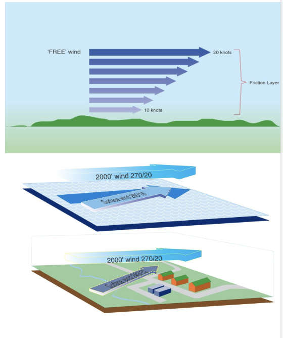
Friction layer
Friction with the earth’s surface cause geostrophic (free) wind to slow down
Slower moving air experiences less Coriolis force so direction also backs (in northern hemisphere)
Friction varies over land and sea
Sea: ~20% decrease, ~10° backing
Land: ~50% decrease, ~30° backing
Friction layer typically ~2000ft thick
Local winds
Local temperature variations drive localised winds
Sea breeze
During the day land warms up more quickly than water
Leads to an on-shore breeze of typically ~10kts below 1000ft
Opposite effect at night as water cools more slowly than land
Katabatic wind (Bora)
Air close to surface of a slope cools at night, increasing in density, flows down under gravity
Can reach over 80kts in snowy conditions
Anabatic wind
Opposite
Humidity
Air can hold invisible water vapour
Warm air can hold more than cold at the same pressure
Air becomes saturated when it can’t hold anymore vapour
Temperature at which this occurs is known has Dew Point
Below this temperature visible droplets form i.e. clouds
Cloud formation
Relationship between dew point and temperature, known as spread, gives an indication of how high clouds will form
Every 1°C spread corresponds to 400ft increase in cloud base
Zero spread means fog/mist
Cloud formation mechanisms
Convection
Air is warmed reducing its density causing it to rise and drop in temperature
Orographic
Air is force to rise as it flows over rising terrain
Advection
Air flows over a cooler surface causing its temperature to drop
Turbulent
Mixing of two atmospheric layers with different temperatures
Convergent
Two air masses meeting forces air to rise
Cloud classification
Cloud type
Cumulus (Cu) - significant vertical extents
Status (St) - significant horizontal extents
Stratocumulus (Sc) - combination of both
Height band
Cirrus (Ci/Cc/Ca) - high altitude
Alto (Ac/As) medium altitude
Presence of precipitation
Nimbostratus (Nb)
Cumulonimbus (Cb)
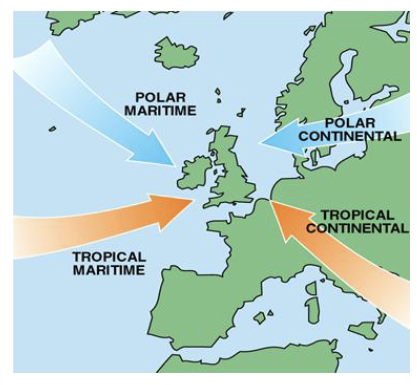
Air masses
An air mass is a large body of air with similar temperature and humidity
UK typically experiences
Tropical maritime
Tropical continental
Polar continental
Polar maritime
Fronts
A front is the boundary between 2 different air masses
Defined by the direction of motion of the masses
Two main types
Warm front - where a warmer air mass is moving into a cooler one
Cold front - where a cooler air mass is moving into a warmer one
Two additional types
Occluded front - occurs when a cold front meets a warm front
Stationary front - when there is no relative motion of air masses

Cumulonimbus
Cumulonimbus clouds - thunderstorms
Strong winds
Heavy precipitation
Hail
Lightening
Turbulence
Windsheer
Severe icing
Electromagnetic interference
Do not fly in the vicinity of them!
Visibility
Water droplets or other contaminants reduce transparency of air
Broadly 2 types considered
Flight visibility
Meteorological visibility
Many factors effect flight visibility
Haze
Layer of smoke or dust in the atmosphere
Slant visibility
Mist and fog
Water droplets in the atmosphere
Two main types
Advection fog
Warm moist air flows over colder surface
Radiation fog
Land cooling overnight with light mixing