8.2 Characteristics and formation of coastal landforms
1/80
There's no tags or description
Looks like no tags are added yet.
Name | Mastery | Learn | Test | Matching | Spaced | Call with Kai |
|---|
No analytics yet
Send a link to your students to track their progress
81 Terms
what is a concordant coastline?
What is a discordant coastline?
concordant = bands of rock run parallel to the coast
Discordant = bands of rock run perpendicular to the coast
Name the three types of rock and give examples of each
→ structure of each rock type
igneous = granite, basalt
→ interlocking crystals which allow for high resistance to erosion
Metamorphic = slate, marble
→ crystal all orientated in the same direction, resisting erosion
Sedimentary = limestone
→ lots of faults making them weak and vulnerable to erosion
What coastal formations form on a discordant coastline?
headlands: reduced rate of erosion compared to softer rock
Bays: increased rate of erosion on softer rock
What coastline does a cove form on:
how do they form?
EXAMPLE
Coves = concordant coastline
a crack in the outer hard rock is attacked by waves
Crack penetrates to softer rock, where the rate of erosion by water increase dramatically
This forms a cove, that looks like a bay, but it is set back by 1 band of harder rock
EXAMPLE = Lulworth Cove, UK: Portland limestone outer rock, then clays, then chalk cliff face again
Name 6 factors that influence cliff shape
hard rock = vertical shape
Soft rock = gently sloping
Dip to sea = slopes towards sea
Dip from sea = vertical + rugged
Rock porosity = water can affect stability
What is a salt marsh?
EXAMPLE
an area in a sheltered bay or behind a spit
Salt and minerals will build up
Vegetation may establish and through vegetation succession stabilise the salt marshes
EXAMPLE = Medmerry Nature Reserve, West Sussex
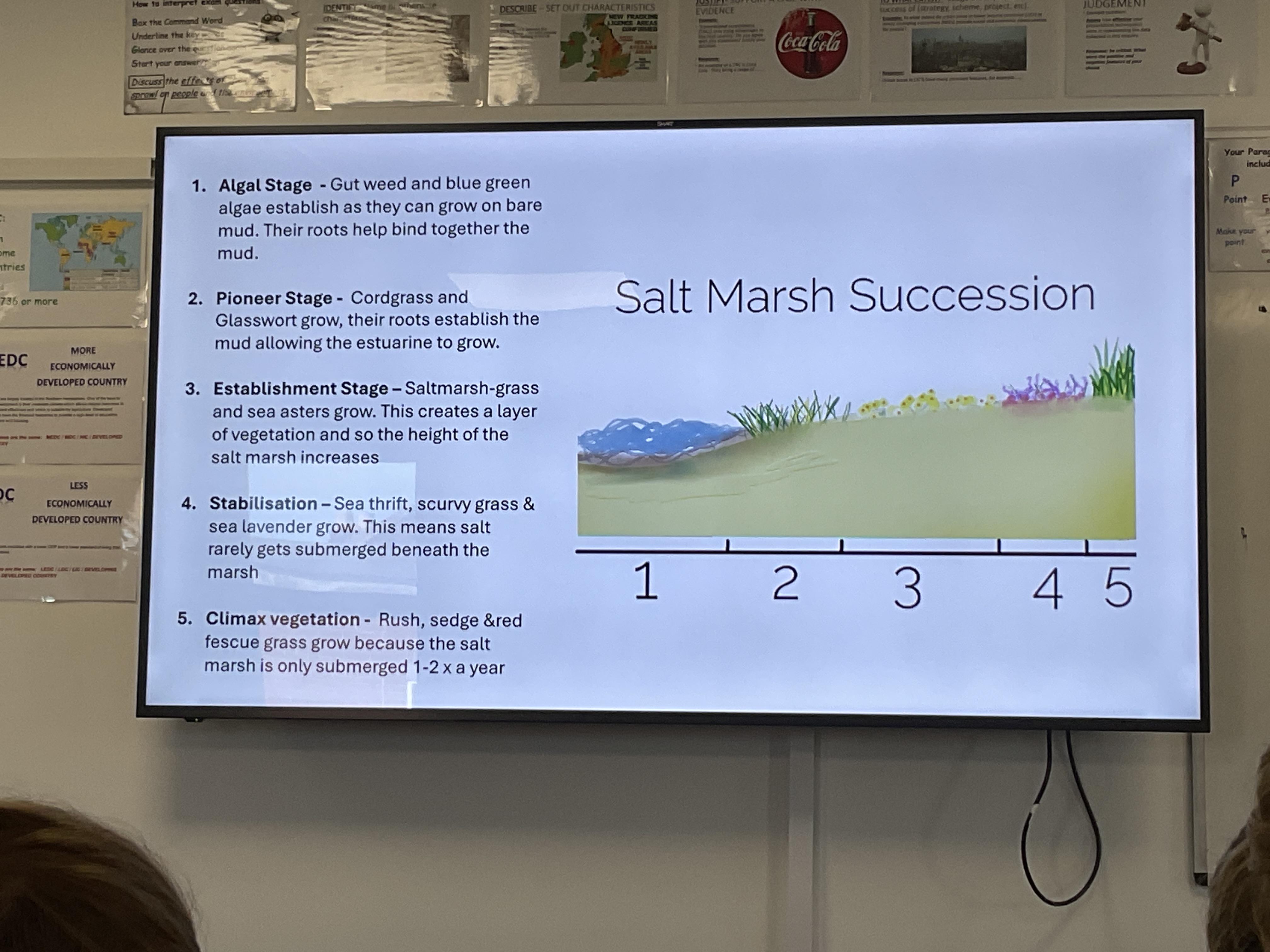
Name the 5 stages of salt marsh succession
Algal stge
Pioneer stage
Establishment stage
Stabilisation
Climax vegetation
Explain plant adaptations for salt marshes
found in temperature regions, these grassy marshland are adapted to saline conditions
Dominated by salt tolerant plants e.g. cordgrasses
What vegetation would be present in the algal stage?
Gut weed and blue green algae establish as they can grow on bare mud. Their roots help bind together the mud
What vegetation would be present in the pioneer stage?
Cordgrass and glasswort grow, their roots establish the mud allowing the estuarine to grow
What vegetation would be present in the establishment stage?
Salt-marsh grass and sea asters (floral plants) grow. This creates a layer of vegetation and so the height of the salt marsh increases
What vegetation would be present in the stabilisation stage?
Sea thrift, scurvy grass and sea lavender grow. This means salt rarely gets submerged beneath the marsh
What vegetation would be present in the climax vegetation stage?ph
Rush, sedge and red fescue grass grow because the salt marsh is only submerged 1-2x a year
What are mangroves?
EXAMPLE
trees adapted to grow in saline, low oxygen conditions
Develop in swamps in tropical regions. This means the environment constantly changes with the tides
Mangroves can stabilise shorelines with roots and protect areas from erosion, as well as providing an environment for wildlife.
Reduce pollution in coastal areas
EXAMPLE = Everglades, Florida
Key mangrove facts
store of carbon (Carbon sink)
Store 20bn tonnes of carbon = 2x annual greenhouse gas emissions
Cover 0.1% of the worlds surface
What is tidal sedimentation? Where does it occur?
Occurs in estuaries due to change in water velocity from a river to ocean
when the water that flows from the river meets the incoming tide and waves from the sea the water virtually stops. The water can then no longer carry its sediment in suspension.
over time this small fine sediment builds up until it is above the water level.
deposition occurs as a result of flocculation
Pioneer plants colonise the area leading to more sediment becoming trapped
Example: chichester harbour
Explain plant adaptations for mangroves
found in tropical regions, mangroves have unique adaptations like aerial roots and salt filtering system (which keeps out up to 90% of the salt)
Mangrove seeds (propagules) start to grow and develop roots on the parent plant → propagules fall into the water and float to shallow areas where their roots can anchor in mud
Leaves have glands which secrete salt, leaving salt crystals on the leaf surface
These adaptions allow them to thrive in intertidal zones with varying salinity
Benefits of mangroves
Biodiversity and carbon storage: provide habitats, act as long-term carbon sinks by storing carbon in the soil
Economic opportunities: estimated economic benefit of £27,000-£45,000 per hectare per year, provides productive fishing areas.
Coastal protection: reduces damage caused by coastal flooding, less expensive to restore mangfrove belts.
Threats to mangroves
overfishing
Pollution
Forest clearance
River discharge changes
Soil erosion
Climate change
Loss of other marine habitats
Explain why pollution is a threat to the mangrove coastline
Species are covered by oil pollution and microplastics can be ingested by fauna.
Fertilisers and pesticides used in agriculture are present in run off and can change the pH and toxicity of the mangrove habitat.
Explain why forest clearance is a threat to the mangrove coastline
natural resources are taken for fuel wood and charcoal production
Space is cleared for waterfront development for tourist activities, port infrastructure, legal and illegal shrimp farming, and salt harvesting
Explain why loss of other marine habitats is a threat to the mangrove coastline
a decline in the number of coral reefs can affect the mangrove ecosystem.
Coral reeds provide a natural barrier that protects mangroves from high waves and strong currents
Removal of coral reeds reduces the supply of fine sediment in which mangrove seedlings grow = more difficult for mangrove forests to become established and reduces the nutrients that are available to them.
Explain why river discharge changes is a threat to the mangrove coastline
the amount of freshwater reaching mangrove habitats is reduced by damming rivers upstream and by increasing irrigation for agriculture.
A decrease in freshwater supply increases the salinity of the water surrounding mangrove forests and may cause the mangrove ecosystem to dry out.
Explain why climate change is a threat to the mangrove coastline
rising sea levels and increased extreme storm events make mangrove forests more vulnerable to coastal flooding
Explain why soil erosion is a threat to the mangrove coastline
deforestation increases the soils susceptibility to erosion
This increases the sediment in both rivers and coastal areas
Mangroves cannot filter this additional sediment and are in danger of silting up.
Why does sea level change?
Short period of time
Long period of time
Tides, low pressures during storm surges (atmospheric pressure changes), wind
Climate change, global warming, isostatic and eustatic change in sea level
What can cause sea levels to rise?
Change in the level of the actual sea OR a downward or upward movement of the land which means that the sea level relative to the land has changed.
Name the 3 scenarios that can lead to a FALL in relative sea level
Sea level falls and land either rises, stays still or subsides at a slower pace
Sea level remains fixed with the land rises
Sea rises but the land rises at a greater pace
Name the 3 scenarios that can lead to a RISE in relative sea level
Sea level rises and land either subsides, stays still or rises at a slower pace
Sea level remains fixed whilst the land subsides
Sea level falls and the land subsides at a greater pace
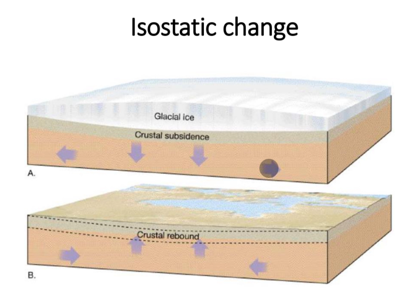
What is an isostatic change?
Local-scale sea level changed caused by either depression or elevation of the Earth’s crust in one particular place
→ due to isostatic subsistence (dropping land) (always to do with the weight of ice)
State an example of isostatic change due to tectonic activity.
Bandeh Aceh, Sumatra: 2004, Earthquake, caused the land to fall 0.5 metres, Indian Ocean
What is isostatic rebound/recovery
When the ice melts and the land rises
Explain isostatic changes in Britain
In the ice age Scotland had more ice than the south of Great Britain.
As the ice melted isostatic rebound occurred which caused the land to rise up.
North/west of Scotland are still getting 2mm a year of isostatic rebound due to ice melting.
What is an eustatic change?
Global-scale sea level change caused by a change in the volume of water in the ocean store
Example of eustatic change
Thermal expansion (when water is warmed)
Thermal contraction (when water is cold)
Cold temperatures → increase in number of glaciers and amounts of sea ice = sea level will drop
Definition of emergent landforms
Occur where there has been relative FALL in sea level (marine regression) / land has raised in relation to coastline
→ raised beaches, relic cliffs
Definition of raised beach
Flat or gently inclined surface that is above the high tide level formed due to isostatic rebound.
Common on the West coast of the UK.
How does a raised beach form?
Beach deposits and shell beds would have been formed when the sea was previously at a higher level and subsequently fallen.
These raised shore platforms create a terrace, an area of flat land, which is backed by the relic cliffs. The presence of the raised platform indicates that before sea level fell, the sea must have been at a relatively fixed level for a considerable period of time to have allowed that platform to develop.
Example of a raised beach
Tongue Bay, Sunderland, UK
What is a relic cliff?
An old cliff displaying features such as caves, arches and stacks
Definition of submergent landforms
→ examples?
Occur where there has been a RISE in relative sea level (marine transgression) / coastline has lowered
Sea may isolate some ares of land to form islands
→ rias, fjords, Dalmation coasts
What are rias? Give an example
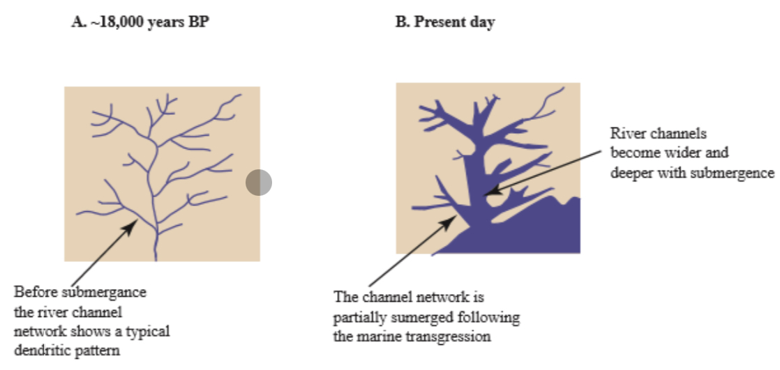
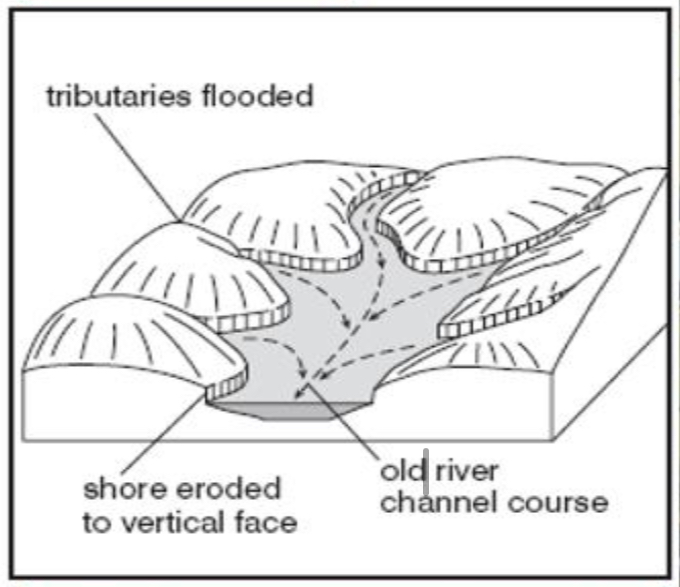
Submerged river valleys that have been submerged during a period of marine transgression.
The lowest part of the river’s course and the floodplains alongside the river may be completely drowned, but the higher land remains exposed
→ example = Sydney Harbour, Australia
How do rias form?
When sea levels were lower than present, base level was lowered, giving rivers a renewed potential energy to cut downwards. Rivers will therefore erode deep river valleys during these times of lowered sea levels
When sea levels rise, the deepened segments of the rivers situated at the coast are filled as the sea level increases, creating the drowned river valley with its characteristic dendritic drainage pattern.
What is the pattern of a rias?
Dendritic pattern (branching)
Where are rias most common?
Along discordant coastlines where geological strata, mountains and hills trend at right angles to the coastline.
What coastline do Dalmatian coastlines form on?
What are Dalmatian coasts
Give an example
Dalmatian coastlines = concordant coastlines
Wide, open bodies of water called sounds develop, which have islands or ridges of raised land between them due to the land being flooded.
EXAMPLE = Croatian Dalmatian coasts
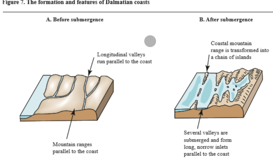
How do Dalmatian coast form?
waves travel at an angle to the bands of rock
Increased rates of erosion on softer rocks leave behind only the harder bands of rock
What are fjords? Give an example
Drowned glacial valleys which have been shaped by the action of ice and submerged during the Holocene (the time since the last Ice Age)
→ Milford Sound, New Zealand
How do fjords form?
deep, steep-sided glacial troughs carved out by moving ice are submerged as sea levels rise
Deep troughs are best formed at higher altitudes where the effects of ice have been more profound.
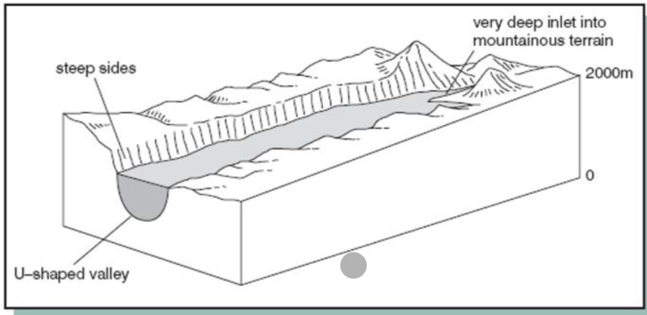
Characteristics of a fjord
steep valley sides
Fairly straight and narrow
U-shaped cross-section with hanging valleys on either side
Shallower section at the mouth called a threshold → due to reduced glacial erosion as the glacier came into contact with the sea.
What is a beach?
→ how are they created?
A depositional landform that stretched from roughly the low tide to high tide line
→ created when sediment is deposited near the coastline when waves lose their energy
→ backwash is often weaker than the swash - water percolates into the sand → as backwash is not powerful the larger sediment remains at the top od the beach
What is prevailing wind?
A wind from the direction that is predominant or most usual at a particular place or season
What is a swash aligned beach
→ characteristics
Example
where waves and wave crests approach parallel to the coast
Form when energy is low
Limited longshore drift = sediment does not travel far as little horizontal/lateral movement
Wave refraction may reduce the speed of high energy waves leading to the formation of a shingle beach with larger sediment
→ example = Lulworth Cove
Why do different beach types occur?
The effectiveness of transportation is dependent on the angle of prevailing wind in relation to the land
What is a drift aligned beach?
→ example
waves approach at a significant angle due to longshore drift
Larger sediment found at start of the beach
Weathered sediment travels further: small sediment at end of beach
→ Chesil Beach, Dorset
What is a spit?
EXAMPLE
a long narrow strip of land formed from longshore drift
Causes beach to extend out to sea usually due to a change in direction of the coastline
EXAMPLE = Hayling Island
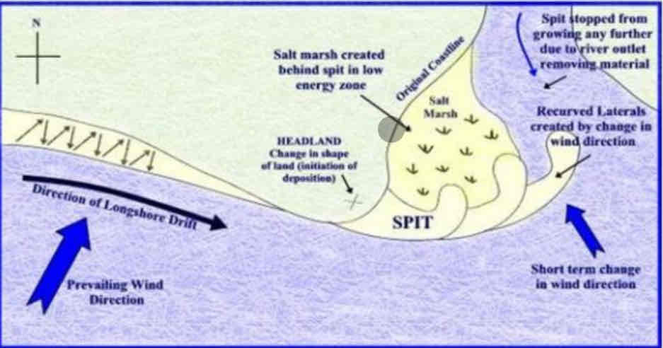
Explain how spits are formed
sediment is transported by waves along s coastline by longshore drift
When the coastline changes direction the waves no longer have the energy to carry the sediment and it is deposited
The build up of deposited sediment out to sea, often into an estuary, is called a spit
The spit often has a curved end or hooks due to a secondaey prevailing wind
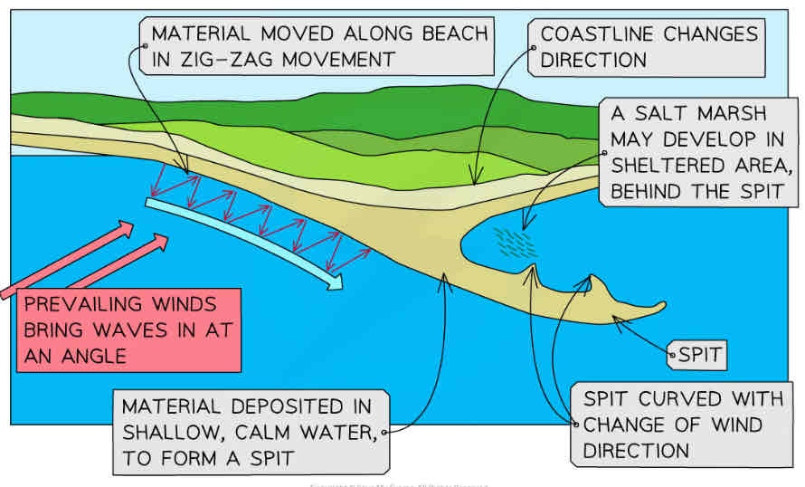
How does the spit formation lead to salt marsh
sediment projection can create a salt marsh due to the sheltered, saline environment where water flow is lower, allowing deposition of finer sediments to occur.
Characteristics of a spit
Behind the spit (leeward side) salt marshes can form: saline, slow moving water, deposition
Opposite = windward side
Length of the spit will depend on changing currents or rivers but will never extend across an estuary
What forms a recurved end to form on a spit?
A change in wind/wave direction/current/weather can cause the end of a spit to curve
What is a compound spit?
EXAMPLE
A spit with multiple recurved ends
Hurst Spit
What is an offshore bar?
→ how do they form?
→ example
Can be formed in different ways:
when the waves do not have enough energy to carry sediment to shore
Formed when the wave breaks early, instantly depositing its sediment - this loose sediment builds an offshore bar
They may also be formed as a result of backwash from destructive waves which remove sediment from the beach
→ outer banks, North Carolina, USA
What do offshore bars do?
absorb energy
Reduce erosion in some areas
What is a tombolo?
→ how do they form?
EXAMPLE?
A spit that connects the mainland to an offshore island and may be covered at low tide
→ formed due to wave refraction off the coastal island reducing wave velocity - meaning deposition is able to occur
→ EXAMPLE = Chesil Beach, Dorset
What is a barrier beach?
occurs when a beach or spit extends across a bay to join 2 headlands
Traps water behind it (creating a brackish (salty water) lagoon)
Form due to longshore drift
When does a barrier island form?
When a barrier beach becomes separated from the mainland forming a barrier island.
EXAMPLE of:
a barrier beach
A barrier island
Slapton Sands, Devon
Scolt Head Island
How do sand dunes form?
EXAMPLE
occur and form when prevailing winds blow sediment to the back of a beach
West Wittering
What conditions are needed for dunes to form
Formation of dunes requires large quantities of sand and a large tidal range → means sand is dry enough and light enough to be picked up by the wind and carried to the back of the beach
Frequent onshore winds are necessary
Dunes develop further as a process of a vegetation succession
Name of dunes starting with the dune closest to the sea
SEA
Embryo dune
Fore dune
Yellow dune
Grey dune
Mature dune
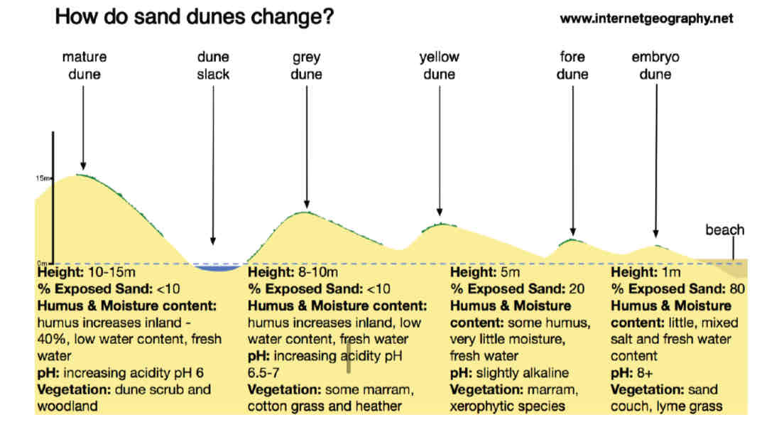
How do the following change as you move from the dune closest to the sea to the dune furthest away from the sea:
organic matter
Number of plant species
Water content
Influence from the sea
Increases
Increases
Increases
Decreases
What is wave refraction?
The process by which waves turn and lose energy around a headland on uneven coastlines
Wave energy is focused on the headlands, creating erosive features
Energy is dissipated in bay leading to features associated with lower energy environments such as beaches
Where do cave, arch and stack form?
explain the formation
EXAMPLE
At a headland, where the rock is hard, erosion is slow where wave refraction concentrates wave energy onto the headland
joints in the headland are susceptible to erosion by hydraulic action and abrasion
Over time the joints widen forming a cave which is enlarged by hydraulic action and abrasion
Eventually marine erosion + sub-aerial processes cuts through the headland forming an arch
The roof of the cave is unstable and will eventually collapse due to gravity and the lack of support
This leaves a stack which over time will be eroded by weathering, abrasion and hydraulic action to form a stump
EXAMPLE = Old Harry Rocks
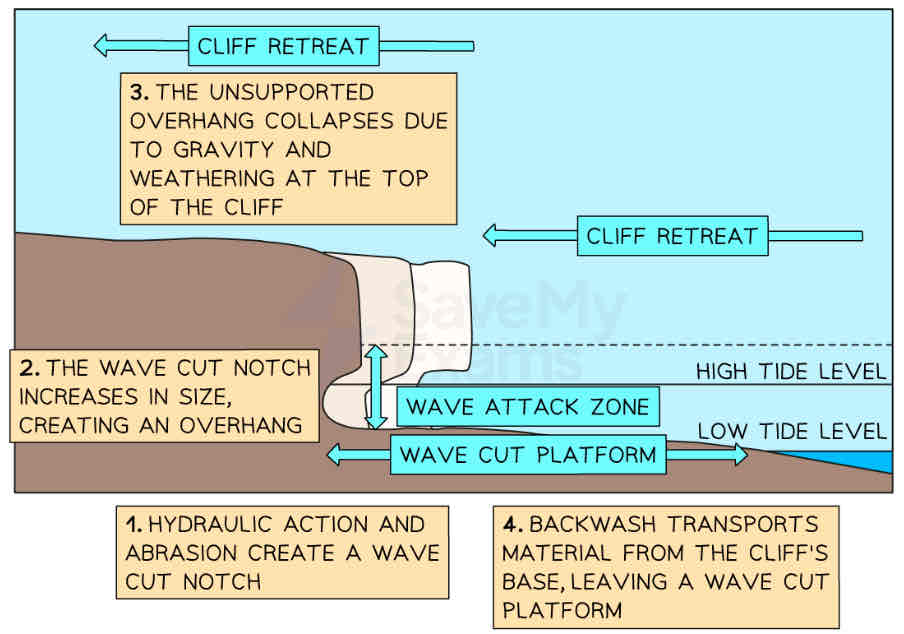
How do wave cut platforms form?
powerful destructive waves attack the base of the cliff at high tide
The hydraulic action and abrasion create a wave-cut notch which over time increases in size → undercutting
Eventually the overhang created by the undercutting collapses due to weathering anf gravity
The cliff retreats, leaving a wave cut platform that is exposed at low tide
What is an estuary?
The point where a river meets an ocean
When does deposition of sedimentation occur in the estuary?
deposition occurs in river estuaries due to a change in water velocity from a river to an ocean when the flow of water from the river meets with the incoming tides and waves from the sea, the water flow practically ceases.
As a result, the water can no longer carry the sediment in suspension and therefore it gets deposited.
Name 3 factors that affect the process of sedimentation in estuaries
tides and waves
Water density
Vegetation
Explain how tides and waves can affect the process of sedimentation in estuaries
tidal currents provide a steady source of energy for sediments moving both into and out of an estuary with flood waves carrying in a large volume of material in suspension.
During storm events: waves entering the estuary entrances can stir up huge amounts of sediment + with oncoming tides this moves into the estuary
Waves generated inside the estuary basin can also scour sediment from the areas
As most of the sediment is small and fine it leads to a build-up of mud which, overtime builds up until it is above water level
Explain how water density can affect the process of sedimentation in estuaries
fresh water is less dense than seawater and floats over it
When sediment enters the estuary it remains in suspension with the river water and can be flushed out to sea quite quickly
However, heavier particles fall out of suspension and sink to the bottom as the flow meets saltwater
This is why sediment deposition in greatest near the upper reaches of the estuary
Explain how vegetation can affect the process of sedimentation in estuaries
vegetation within the estuary causes deposition as it slows down the speed of the water, increasing rates of deposition
Over time, the surface of the mudflats may become higher than the surface of the estuary and can be colonised by terrestrial species
Mud flats and salt marshes may develop as a result of sedimentation which is increased by their relatively sheltered nature, providing low energy environments in which sedimentation is deposited as it cannot be carried any longer.
Give an example of where tidal sedimentation occurs in estuaries
Crow Stone, London
Langstone Harbour