The Water Cycle and Water Insecurity - Edexcel A Level geography
1/99
There's no tags or description
Looks like no tags are added yet.
Name | Mastery | Learn | Test | Matching | Spaced |
|---|
No study sessions yet.
100 Terms
What is the water cycle?
The cycle operates in a variety of spacial scales where physical processes control the circulation of water between stores on land, oceans, the cryosphere and the atmosphere.
It works as a closed system with inputs (rainwater), outputs, stores and gravitational potential energy.
It begins with evaporation where water vapour from the ocean is lifted and condensed in the atmosphere to form clouds.
Moisture is then transported around the globe and returns to the surface as precipitation.
When reaching the ground some water will evaporate back into the atmosphere whilst some of the water may percolate the ground to form groundwater.
The balance of water that remains on the surface of the earth is called runoff and emptied into lakes, rivers and streams which carry it back to the oceans for the process to start again. This is therefore a closed system.
What is the global budget?
The percentage contribution of water stores varies, with the majority of earths water being in saline oceans and freshwater being largely in ice caps and glaciers.
The global budget limits water availability for human use and water stores have different residence times; some stores, such as those storing fossil water, are non renewable e.g. Ogalla aquifer in the USA High Plains stored fossil water from previous glacial melt so cannot recharge quickly.
Ice Age vs. Now
Ice Age - more water was held within the cryosphere in solid form as snow and ice; as less was held in the oceans, sea levels dropped.
Now - recent climate warming is beginning to reverse this with major losses of ice in Greenland and Antarctica meaning significant rise in sea level.
What are the four major stores?
Largest is Ocean containing 96-97%, next is the cryosphere, then terrestrial surface groundwater and the smallest is the atmosphere.
What affects residence time?
Some accessible stores e.g. soil, lakes = shorter residence times, it is easily lost to other stores by evaporation, transportation, groundwater flow or recharge.
Atmospheric water has shortest residence time
Strong link with residence times and water pollution - stores with slower turnover = easily polluted as waters situ longer.
Accessible water for human life support
96-97% water stored in oceans - only around 2.5% occurs as fresh water.
69% locked in snowflakes, ice sheets, ice caps and glacier found in high latitudes and altitude locations - largely inaccessible for human use.
30% is groundwater, some very deep seated as fossil water therefore inaccessible.
Only around 1% fresh water easily accessible for human use.
Rivers main source of surface water for humans only 0.007% of total water.
Technology is being used widely to extend availability of fresh water supplies e.g. by desalination of ocean water.
What is the drainage basin water cycle?
It's a subsystem within the global hydrological cycle.
An open system as it has external inputs and outputs causing amount of water in basin to vary over time due to different temporal scales, from short term hourly to daily, seasonal and annual.
It's the area if land drained by a river and its tributaries frequently referred to as a river catchment - boundary of a drainage basin is the watershed (ridge of high land divides and separates water flowing to different rivers.
They can be of any size, from a small stream without tributaries to international river flowing across borders of several countries.
How is precipitation a drainage basin input?
Conditions needed; air cooled to saturation point with a relative humidity, condensation nuclei i.e. dust particles to facilitate growth of droplets in clouds and temperature below dew-point (temp at which dew forms; atmospheric moisture).
What are the types of rainfall and what are their traits?
Convectional - intense thunderstorms, ground heating e.g. Tropics and continental interiors - land is hot, air heats and ability to hold water decreases
Cyclonic - period of sustained, intensive rain associated with passage of depressions - warm air forced to rise over cold dense air, it cools and its ability to hold water decreases.
Orographic - concentrated on windward slopes and summits of mountains - air forced to rise it cools and condensation occurs causing rain.
Rain shadow - dry area on leeward (downwind) side of mountain, has little rain as it's sheltered.
Interception as a flux in the drainage basin
Process: water stored in vegetation. Three main components: interception loss, throughflow + stem flow.
Loss through vegetation greatest at start of storm. Interception capacity of vegetation varies with tree type; with dense needles of coniferous forests allow greater accumulation. Also contrasts between deciduous forests in summer/winter.
Meteorological conditions - coniferous forest intercepts 25-35% annual rainfall, deciduous forests 15-25% and arable crops 10-15% - wind speed decrease interception loss + increase evaporation rates - intensity and duration of rainfall means interception decreases with more rain = saturated = more excess water will reach the ground.
Infiltration as a flux in the drainage basin
Process: water soaks into the soil - infiltration capacity is maximum rate at which rain can be absorbed by soil in a 'given condition' depends on:
Infiltration capacity decreases with time through period of rain until more or less constant low value reached.
Amount of water already in the soil as surface or overland flow will occur when soil is saturated.
Soil texture influences soil porosity, sandy soil capacity 3-12mm/hr less permeable clays 0-4mm/hr.
Type, amount and seasonal change in vegetation cover, infiltration significant in land covered by forests (50mm/hr) or moorland (42mm/hr).
Nature of soil surface and structure - compacted surfaces inhabit infiltration (10mm/hr) .
Slope angle - steep slopes encourage overland run off, shallower slopes promote infiltration.
What are the factors that the influence the drainage basin? How do they influence the basin?
Amount of precipitation - impacts discharge; higher amount the less variability in its pattern.
Type of precipitation - e.g. snows a temporary store and large flux of water can be released rapidly.
Season - climates e.g. monsoon, strong seasonal patterns of rainfall/snowfall impact processes.
Intensity - impacts flows, difficult for rain to infiltrate if intense as soil capacity is exceeded.
Variability - secular; long term due to climate change - periodic; annual, seasonal, monthly etc, stochastic; random i.e. localisation thunderstorm.
Distribution - impact noticeable in large basin e.g. Nile, at local scale and shorter time scale thunderstorm impact temp as inputs will vary.
What are the flows and transfers in a drainage basin and how do they work?
Overland flow - main way rainwater transferred to river channel - result of precipitation rate exceeding infiltration - primary agent of soil erosion due to rain splash, sheet, rill and gully erosion - features of many urban areas.
Throughflow - lateral transfer of water downslope through soil via natural pipes + percolines - slower than direct overland flow, this shallow transfer can occur quite rapidly on porous, sandy soils.
Percolation - deep transfer of water into permeable rocks - those with joints or those with pores - throughflow percolation route associated with humid climates with vegetation slopes.
Saturated overland flow - slower transfer process result of upward movement of water table into evaporation zone - succession of winter storms i.e. UK 2015 water table rises to surface in depressions + at the base of hill sides = saturated overland flow contributes to channel flow.
Groundwater flow - slow transfer of percolated water through previous or porous rocks - vital in maintaining steady level of channel flow in varying weather conditions.
Channel flow - takes place in river once water from three transfer processes (overland flow, throughflow, groundwater flow) reaches it.
What are the drainage basin outputs and how do they work?
Evaporation - moisture lost into atmosphere from water surface and soil - climatic factors = temperature, hours of sunshine, humidity and wind speed - other factors = size of water body, depth, quality, type of vegetation.
Transpiration - biological process - water lost from plants through minute pores (stomata) and transferred to atmosphere - depends of time of year, amount of vegetation and moisture in atmosphere.
Evapotranspiration - combined effect of evaporation and transpiration - removal of nearly 100% of annual precipitation in arid areas 75% in humid.
Potential evapotranspiration - water loss occur if there was unlimited supply of water in soil for use by vegetation.
What are the physical factors influencing the drainage basin? How?
Climate - influencing the type and amount of precipitation overall and amount of evaporation i.e. Major inputs and outputs - also impact on vegetation type.
Soils - determine amount of infiltration and throughflow and type of vegetation.
Geology - impact on subsurface processes i.e. percolation and groundwater flow, alters soil formation.
Relief - altitude can impact on precipitation totals, slopes can affect amount of run-off.
Vegetation - presence or absence has a major impact on amount of interception, infiltration and occurrence of overland flow and transpiration rates.
How does the human impact on precipitation influence the drainage basin?
Cloud seeding: introduction of silver iodide pellets or ammonium nitrate act as condensation nuclei to attract water droplets - aim to increase rainfall in drought stricken areas - variable results
How does the human impact on evaporation and EVT influence the drainage basin?
Change global land use e.g. deforestation - increase evaporation from artificial reservoirs behind mega damns i.e. Lake Nasser in Egypt - channelisation into conduits cuts surface storage and evaporation.
How does the human impact on interception influence the drainage basin?
Determined by vegetation type and density, deforestation and afforestation.
Deforestation = reduction in evapotranspiration and increases surface run off increasing potential floods, decline of surface storage and in lag time between peak rainfall and peak discharge - speeds up cycle.
How does the human impact on infiltration and soil water influence the drainage basin?
Result from change in land use - infiltration up to 5x greater under forests compared with grassland - conversion to farmland reduced interception + more overland flow - grazing cows means soil is compacted, ploughing increases infiltration - water logging and salinisation common for poor drainage.
How does the human impact on groundwater influence the drainage basin?
Human use of irrigation for extensive cereal farming led to declining water table levels.
Aral sea over extraction of water - began shrinking 1960s schemes for growth of cotton took water from rivers reducing water reaching Aral sea. 1994 levels fallen by 16m, surface area by 50% and volume by 75% and salinity levels increased by 300%.
British cities reduction water using manufacturing = less groundwater abstracted = levels rise, problems = flooding cellars/ basements and supplies polluted etc.
Deforestation of the Amazon Rainforest - case study
Environmental impacts are likely to be severe because of the sheer scale of the deforestation taking place.
Over 20% of the forest has been destroyed, at an accelerating rate in the last 50 years, by a combination of cattle ranching, large scale commercial agriculture for biofuels and soya beans, general development of towns and roads, as well as legal and illegal logging.
Amazon forest contains 60% of the worlds rainforests, so the environmental impact on global life support systems is bound to be highly significant.
Trees act as 'green lungs; by removing CO2 as they photosynthesis acting as carbon sinks. Destruction of forests reduces this capacity so, adding the global greenhouse gas emissions, especially in times of drought.
There is a huge impact on water cycle. In forest environment 75% of intercepted water is returned by EVT to atmosphere, reduces 25% when forest is cleared.
Drier climate leads to desiccation and further degradation. The El Nino- southern Oscillation can lead to significant occurrence of drought in Amazonia, which can exacerbate forest fires and further destruction.
Severe flooding and mudslides exacerbated by water run off into drainage system it also leads to aquifer depletion as less water infiltrates to recharge them. Overland flow increases amount of soil erosion.
Trees critical to brazils water supply without them transpiration cannot occur meaning little rain - brazil is feeling effects of deforestation especially in Sao Paolo.
What are water budgets?
Balance between precipitation, evaporation and runoff, useful at global, regional and local scales
Water balance varies between continents: south America most well-endowed continent and Africa the least.
Run off is divided into surface flow and base flow important as certain places there's seasonal differences in surface flow e.g. monsoonal areas some time of the year may be shortages of water but others a surplus.
Water supply problems on some continents e.g. Africa precipitation and EVT very similar leaving little waters to enter rivers as surface run off - contrast South America has large precipitation and EVT afferent leading to high surface run-off.
Water budgets at country or regional scale provide useful indication of available water supplies - local scale show annual balance between inputs and outputs and how they impact soil water availability.
Soil moisture budget is subsystem of catchment water balance and is of vital importance to agriculturalists - drainage basin water budgets are usually called water balances and usually expressed using formula:
P=Q+E±S P=precipitation, Q = discharge, E = evapotranspiration, S = changes in storage.
Influenced by: temperature: faces mild temp + steady climate - Tropical: can be tropical wet, tropical monsoon or tropical wet and dry seasons - polar: Tundra and ice caps climates. Tundra summers are short + in ice cap seasons etc.
What is a river regime?
Defined as annual variation in discharge or flow of a river at a particular point or gauging station, usually measured in cumecs.
Much river flow not from immediate precipitation or runoff but supplied from groundwater between periods of rain, feeds steadily into river system from base water flow - British river flowing over chalk i.e. river Kennet show this feature as they maintain their flow even in dry conditions.
What influences the character of a regime?
Size of river and where measurements are taken in basin.
Amount, pattern and intensity of precipitation; often reflect rainfall seasonal or when snow fields or glaciers melt.
Temperatures experienced: evaporation in summer.
Geology and overlying solids, especially their permeability and porosity: water stored as groundwater gradually released into river as base flow regulates flow in dry periods.
Amount and type of vegetation: wetlands can hold water and release it slowly.
Human activities - e.g. dam building, which can regulate the flow.
The Indus River Regime - case study
Tropical area which has distinct wet and dry seasons, high flow soon after rainfall peak, rivers may dry up all together during the dry season on desert margins.
Meltwater, which is highly sensitive to temperature change, is particularly significant for flow in the Indus Basin. Glacier melt runoff occurs in the upstream areas, and discharge generated by snow and glacier melt is naturally generated in the downstream areas.
The major part of the basin lies in arid-to-semi-arid climatic zones, but there is considerable temporal and spatial climatic variation across the area.
Short spells of heavy precipitation occur in the summer (June to September), while westerlies bring precipitation in the winter and spring. Nearly 50 per cent of the precipitation falls during the monsoon and 40 per cent during winter and spring.
The northern parts have significant snowfall, while the southern parts have comparatively mild weather. The average annual rainfall ranges from less than 100mm to 500mm in the lowlands, and up to 2000mm in the mountains.
Amazon River Regime - case study
The months that get the most precipitation are January, February and March. These months are the ones that get the least evaporation.
The Amazon is in a tropical area so there is distinct wet and dry seasons, high flow soon after the rainfall peak and the river may dry up completely during the dry season on desert margins.
The basin covers about 38 per cent of the surface of South America.
The greater part of the Amazon Rover basin is under impact of the equatorial and subequatorial climate characterised by sufficient wetting and also under the impact of the zones of permeability wet and alternately wet equatorial forests. The upper reaches of the river are characterised by mountain climate.
The river is mainly fed by rains. The maximum amount of atmospheric precipitation is recored in June-August in the upper part of the basin, in May-July in its northern part, and in February-April in its southern part.
The most water abundant period of the year is April-June in the greater part of the river basin, February-March in the south of the basin, and May-July in the lower reaches of the river.
The most water deficient months are October-December in the northern part, July-September in its southern part and October-December in the lower reaches of the river.
The Yukon River Regime - case study
Discharge analysis shows that the run off in the cold season, November-April, is low with small variations, where as it is high with fluctuations in the warm season, May-October.
The Stevens Village Station in the upper basin has similar changes with the floe near basin outlet. Flow increases in May and September and decreases in July and August.
Discharge at the Pilot Station, near the basin outlet, shows a positive trend. Daily flow analysis shows high fluctuation during the warm season and very low flow during the cold season.
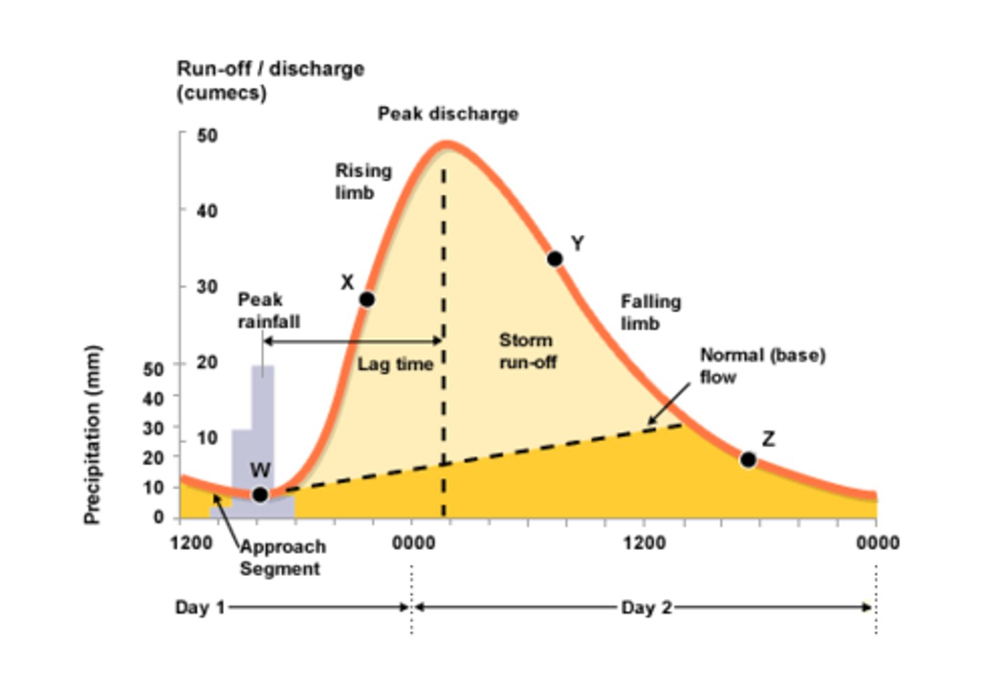
What do storm hydrograph show?
Show variation of discharge within short period of time, normally an individual storm or group of storms not more than a few days in length. Before a storm the main supply to a river is through groundwater or base flow but it comes from; infiltration into soil and becomes throughflow, some flows over surface as overland flow - water reaches river in short time known as quick flow.
What are the main features of a storm hydrograph?
Once rainfall input begins the discharge starts to rise; shown on rising limb.
Peak discharge eventually reached some time after peak rainfall as water takes time to move through the system.
The time interval between peak rainfall and peak discharge is known as lag time .
Once storm input has ceased the amount of water in river starts to decrease shown by falling limb.
Eventually discharge returns to normal level or base flow.
What is the expected shape of a hydrograph for a 'flashy river'?
Short lag time, high peak, steep rising limb.
Climate - intense storm exceeds, rapid snow melt, low evaporation.
Rock - impermeable e.g. granite rapid surface runoff.
Soil - low infiltration rate e.g. clay soil.
Relief - high, steep slopes promote surface runoff
Basin size - small.
Shape - circular have shorter lag time.
Vegetation - bare/low, low levels of interception.
Pre existing - already wet from previous rain.
Human activity - urbanisation = impermeable, deforestation reduce interception.
What is the expected shape of a hydrograph for a 'flat river'?
Long lag time, low peak, gently sloping rising limb.
Climate - steady rainfall, slow snow melt, high evaporation.
Rock - permeable e.g. limestone limited rapid surface run off.
Soil - high infiltration rate e.g. sandy soils.
Relief - low, gentle slopes allow infiltration and percolation.
Basin size - larger.
Shape - elongated basin.
Vegetation - dense.
Pre existing - basin dry, low water table.
Human activity - low population density, few artificial impermeable surfaces, reforestation.
What are the impacts of urbanisation on hydrological processes.
Building activity leads to clearing of vegetation and exposed soils replaced by concrete and tarmac both impermeable.
High density of buildings mean rain falls on roofs then swiftly dispatched into drains by gutters and pipes.
Drains and sewers built reduce distance that storm water must travel before reaching a channel - increase in velocity due to sewers generating less friction.
Urban rivers tend to be channelized with embankments to guard against flooding but when they occur they can be more devastating as river overtops defences in very confined space.
Bridges can restrain free discharge of flood waters ad act as local damns.
Extreme weather events urban areas i.e. Manchester, Leeds and York are highly vulnerable - problem of higher, quicker peak discharge.
Decision makers and planners have a number of options that involve managing catchment i.e. develop appropriate land use e.g. forestry in upper areas and manage development in lower by using zoning limiting building on floodplains.
Also grants for comparatively low cost strategies to lower flood risks e.g. semi permeable surfaces for car parks, high level wiring in houses, affordable insurance and building regulations can be tightened.
What is meteorological drought? What are its features and impacts?
Shortfalls in precipitation result of short term variability, or longer term trends increasing duration of dry period.
Precipitation deficiency usually combined with high temp, high winds, strong sunshine and low humidity increase evaporation.
Causes of rainfall deficiency can be natural variations in atmospheric conditions or caused by deforestation or El Nino + climate change.
Major features - rainfall deficit: low precipitation, high temperature, strong winds, increased solar radiation, reduced snow cover.
Major impacts: loss of soil moisture, Supply of irrigation water declines.
What is agricultural drought? What are its features and impacts?
Overgrazing accelerates it, rainfall deficiency of soil moisture + soil water availability which has a knock on effect on plant growth + reduces biomass.
Soil moisture budget show deficit stage is protracted more severe than normal - outcome is poor yield, decline in quality and well being of livestock and economy affected as farmers require gov aid.
Major features - soil moisture deficit: low evapotranspiration, plant water stress, reduced biomass, fall in groundwater levels.
Major Impacts: poor yields from rain-fed crops, irrigation systems start to fail, pasture and livestock productivity declines, rural industries affected, some gov aid required.
What is hydrological drought? What are its features and impacts?
Reduced streamflow and groundwater levels decreased due to reduced inputs of precipitation and continued high rates of evaporation - results in reduced storage in any lakes or reservoirs, threats to wetlands, linked to decreasing water supplies for urban areas resulting in restriction to control abstraction.
Particular problem in rural north east Brazil with no permanent river and water supplies depend on rainfall in reservoirs and ponds.
Major features - stream flow deficit: reduced infiltration, low soil moisture, little percolation and groundwater recharge.
Major Impacts: reduced storage in lakes and reservoirs, less water for urban supply and power generations-restrictions, poorer water quality, threats to wetlands and wildlife habitats.
What is famine drought? What are its features and impacts?
Failure of agricultural system, food shortages develop having severe social, economic and environmental impacts.
Humanitarian crisis e.g. Horn of Africa 2012-14 require international solutions.
Major features - food deficit: loss of natural vegetation, increased risk of wild fires, wind blown soil erosion, desertification.
Major impact: widespread failure of agricultural systems, food shortages on seasonal scale, rural economy collapses, rural-urban migration, increased malnutrition and related mortality, humanitarian crisis, international aid required.
Why are there deficits in the hydrological cycle?
Population grows and becomes wealthier, demand for water increases. At the same time natural variability in climate causes temporary decline in supply and stores aren't replenished. Long term susceptibility is brought by ENSO + climate change associated with global warming.
High temp leads to increased evaporation - areas affected have doubled including more than 30% of the world in the last 30 years - especially southern Europe, some parts of USA e.g. California, parts of Asia + eastern Australia.
Drought, known as 'creeping hazard', have long period onset making it difficult to determine whether a drought has begun or if its just a 'dry period'.
Physical cause of droughts are only partially understood. Climate dynamics study interlocked systems of atmosphere, oceans, cryosphere, biomass and land surface which interact and produce global climate.
Teleconnections mean development of ENSO within pacific has an impact on climates around the world.
What is a 'normal year' in the El Nino Southern Oscillation (ENSO)?
Trade winds move warm surface water towards Western Pacific.
Cold water wells up along the west coast of south America.
Trade winds WEST, low pressure WEST, cold current EAST.
What is an El Nino year?
Air pressure over west coast of South America becomes low.
Air pressure over northern Australia becomes high.
Normal east to west trade winds over pacific are disrupted and warm water moves east.
Upwelling of cold water on south American coast is suppressed.
Trade winds EAST, low pressure EAST, cold current suppressed.
What is an La Nina year?
Air pressure unusually high over west south America and low northern Australia.
Easterly trade winds are more intense than normal.
More warm water is pushed to the west of the Pacific Ocean.
Trade winds WEST, low pressure WEST, cold current EAST.
What is the cause of ENSO and what are its impacts?
Cause = global warming.
Effects = damages fishing industry in Peru, floods in Peru cause 350,000 to lose homes, hurricanes in Mexico, 1ft snow in Mississippi, ice storm in Montreal and tornado in Georgia.
How can drought be measured and what does each measurement measure?
Palmer drought severity index (PDSI): applies to long term drought, uses current data as drought is dependent on previous conditions. Focuses on monitoring duration and intensity of large scale, long term, drought including atmospheric circulation.
Crop moisture index (CMI): this is a measure of short term drought on a weekly scale and is useful for farmers to monitor water availability during the growing season.
Palmer hydrological drought index (PHDI): the hydrological system responds slowly to drought, reacting and recovering from it. Different models need developed for rivers, lakes etc.
What is desertification?
Land degradation in arid, semi arid and dry sub-humid regions resulting from various factors including climatic conditions and human activities.
What are the human influences on drought?
Make drought even more severe.
Sahel is vast semi-arid region on southern edge of Sahara. It contains several of the poorest developing countries in the world.
Sahel has high variability of rainfall at all climate scales.
Seasonally - its drought sensitive as it occupies a transitional climate zone - normal conditions, mean annual rainfall (85%) all concentrated in summer - varies from 100mm (very arid) on edge of Sahara to 800mm along southern margins.
Annually - year to year huge variability on Saharan fringe - warm sea surface temperatures in tropical seas favour strong conventional uplift over the ocean weakens west African monsoon and contributes to Sahel drought.
Human factors don't cause drought they act at enhancing impacts.
1999-2000 Eritrean drought/famine crisis
10m people needed food assistance.
Impacts increased by socio-economic conditions due to growing environmental degradation from overgrazing, deforestation for fuelwood and high levels of rural poverty.
Rural population densities increased doubling population every 20-30 years so it outstripped food production.
Ethiopia and Eritrean were at war meaning blocked access to food for many people.
Drought in Australia - case study
Two main types of drought:
Serious deficiency - rainfall 10% values record for at least three months.
Severe deficiency - rainfall lowest 5% record for at least three months.
Major physical reasons for drought prone, 30% country usually effected in any 1 year.
Climate dominated by sub-tropic high pressure belt of southern hemisphere.
Droughts vary considerably - some are intense and short lived; some last for years; some very localised; others e.g. 'Big Dry'2006 cover huge areas of Australia for several years
Most closely linked to El Nino i.e. East Coast drought of Southern Queensland 2002-3.
1970s shift rainfall patterns with eastern area, becoming drier compared to north-western areas.
'Big Dry' associated with longer term climate change trend of a warmer, drier climate for south-eastern Australia.
'Big Dry' 1-in-1000 year event spread nationwide. Affected more than half farmlands, especially Murray Darling Basin provides 50% of nations agricultural outputs - disastrous impacts on Australia's food suppliers and wool, wheat and meat exports - farmers irrigated farming of rice, cotton and fruits.
Reservoirs fell to around 40% of their capacity. Adelaide was vulnerable as it drew 40% of drinking water from river Murray. Recent years over-extracted that no water has flowed at its mouth - growing population used to an affluent water consuming lifestyle, per capita water consumption is one of the highest in the world - over-extracted for agricultural, industrial and urban usage.
Future demands exceed supply, new schemes for urban areas must be developed to include desalination plants, large scale recycling of grey water and sewage, more strategies for water conservation.
What is a wetland?
Wetland a term that covers a multitude of different landscape types. Covers 10% of earth's land.
Their importance means their conservation is a political priority.
What are the key functions of wetlands?
Act as temporary water stores within hydrological cycle, mitigating river floods downstream, protecting land from destructive erosion by acting as wash lands and recharging aquifers.
Chemically they act like giant water filters by scrapping and recycling nutrients and pollutants which help maintain water quality.
High biological productivity support very diverse food web, providing nursery areas for fish and refuges for migrating birds.
All contribute to their value for human society, as providers of resources, services in terms of hydrology within water cycle and as carbon stores within carbon cycle.
What are the impacts of wetland destruction?
Major impact on wetlands with limited precipitation = less interception, less infiltration and percolation to the groundwater stores, causing water table levels to fall - process of evaporation might increase - transpiration will decrease making wetlands less functional.
Physical causes of wetland loss, perhaps 2.5m square km destroyed in Europe and USA largely for agriculture and urban development.
Schemes led to wetland drainage, including water transfer schemes e.g. Jonglei Canal Project diverted the White Nile discharge from the Sudd Swamp to dry land areas of South Sudan, or the degradation of Okavango Delta in Botswana for cattle rearing. Exploiting fuel resources e.g. peat, is another reason for loss.
Marshland of southern Iraq almost completely destroyed by dams on the Tigris and Euphrates, reducing their flow and also by Saddam Hussein's drainage schemes, to destroy the lifestyle of 250,000 Marsh Arabs. Since the overthrow of Saddam 2003, water allowed to flow again.
Concerns about wetland habitat destruction, schemes have been developed at a local, national and international scale to protect them. The 1991 Ramsar Convection on wetlands has listed over 1800 wetlands of international importance, covering 1.7m square km in 160 states, to promote their conservation.
As ecosystems play e.g. role within the hydrological cycle, it is clearly important to keep them in a pristine state where possible, and to ensure their sustainable use.
What is the value of wetlands?
Supporting: primary production at a very high level, food chain support, carbon state within life support system of carbon cycles.
Regulating: food control, groundwater recharge/discharge, shorelines as change and to protect, water purification.
Provisioning: fuelwood, peat, estuaries, mammals and birds as tourism.
Cultural: aesthetic value, recreational use, cultural heritage.
What are the environments that are most at risk to flooding?
Low lying parts of flood plains and river estuaries, also subject to groundwater flooding after ground becomes saturated.
Low lying areas particularly urbanised with impermeable surfaces.
Small basins, especially in semi-arid/arid areas subject to flash flooding - short lag time often minutes or hours (extremely dangerous).
What are the causes of flooding?
Climatological: rain, snow, ice melt, combined rain and melt.
Part-climatological: estuarine interactions between streamflow and tidal conditions, coastal storm surges.
Other: earthquake, landslide, failures of dams and other control works.
What are the flood intensifying conditions?
Basin characteristics: stable - area, shape, slope, aspect, altitude. Variable - interactions between climate, geology, soil type, vegetation, wildfire and human influence = difference in storage capacity, infiltration, transmissibility
Network characteristics: stable - pattern. Variable - surface storage, channel length/ contributing of source area, under-drainage.
Channel characteristics: stable - slope, flood control and river regulation works. Variable - roughness, load, shape and storage.
What caused the UK floods?
Prolonged and heavy rain, passage of low pressure systems or depressions - traditionally autumn/winter but unusual positions in jet stream means that floods occur at other times e.g. summer floods 2007-8.
Degree depends on depression sequence - sometimes intense storms have cumulative effect on drainage system e.g. UK October-December 2015.
Boscastle flood 2004 - case study
Causes: over 60 mm of rainfall (typically a month's rainfall) fell in two hours. The ground was already saturated due to the previous two weeks of above average rainfall. The drainage basin has many steep slopes, and has areas of impermeable slate causing rapid surface run-off. Boscastle is at the confluence (where tributaries meet) of three rivers - Valency, Jordan, and Paradise. A large quantity of water all arrived within a short space of time causing the rivers to overflow. The flooding coincided with a high tide, making the impact worse.
Effects: homes, businesses and cars belonging to more than 1,000 people were swept away. Income from tourism was lost. This had an impact on livelihoods and the local economy. There were vast numbers of subsequent insurance claims. No lives were lost, partly due to the rapid response of the emergency services.
What are the physical factors affecting floods?
Vegetation: greater cover = higher levels of interception, storage and evapotranspiration which reduces rainfall and increases lag time.
Soil depth: deeper soil absorbs more water and results in less run-off.
Slope: steeper-angled slopes mean less water is absorbed and more runs off.
Rock type: permeable rock allows greater infiltration and ground storage, leaving less water to run off.
Drainage density: length of stream(km), drainage basin area(km2), drainage density low = longer lag time and reduced risk of flooding.
How is urbanisation a key factor in flooding?
Impermeable surfaces e.g. London, land taken up by carparks 25 square km, 60% residents pave gardens for cars.
Speed up drainage by artificial conduits e.g drains.
Channel flow building alongside river e.g bridge supports.
Straightening channels to increase flow result in floods downstream - mismanagement moving water at faster rate at expense of environment.
Land use change associated with agricultural development - deforestation, overgrazing, ploughing or drowning wetlands.
Urbanisation concentrated on lower-lying land within drainage basin = natural and human factors enhance frequency and magnitude of flood risk.
2015 recurrent flood where flood defences built only a decade ago (Carlisle, Cockermouth) major topic in UK and EU - some events (Cumbria) of higher magnitude than previously.
What are the human causes of flooding?
Ploughing compacts soils, overgrazing does the same.
Impermeable surfaces e.g. tarmac.
Deforestation reduces interception.
Natural streams have meanders and marshy areas, channelisation does not.
What did the British media (public and social) blame the 2015 floods on?
Extreme weather induced by climate warming.
Budget cuts spent on flood defences.
Green priorities of the EU water framework directive, puts environmental concerns before regular maintenance.
Poor land management e.g. blocking ditches or overgrazing it.
What are the socio-economic impacts of flooding?
Degree of threat depends on depth and velocity of water, duration, quality of water - 0.5m deep can wash cars away, + 2m per sec foundations of buildings start to collapse.
Depth - many in developing countries cannot swim, are killed by poisonous snakes in the water - children and old people are most vulnerable.
Post flood morbidity likely in low income countries mainly water borne diseases.
Affect livelihood's - structural damage = major cause of tangible flood loses - concerns post flooding getting insurance against future events and coping with reduced property values.
Crops, livestock and agricultural suffer major damage in intensively farmed rural areas = subsistence there is a direct loss of food supplies and famine can occur - lead to escalating food prices, as in big dry in Murray Darling Basin Australia 2006.
Cockermouth, Cumbria destruction of bridge connecting towns = communication and transport hard.
Mega city e.g. Mumbai infrastructure loses common.
Affects tourism e.g. Cumbria loss tourism for a year.
What are the environmental impacts of flooding?
Death and destruction from socio-economic impacts - positives e.g maintaining key ecosystem functions and biodiversity linking river with land.
Floods can recharge systems, fill wetlands, increase connectivity between aquatic habitats, move sediment and nutrients around the landscape and into marine environments - many species floods trigger breeding, migration and dispersal.
Natural ecosystems resilient = increased productivity and maintenance of recreational environments.
Environments degraded by human impacts are negative - leads to oversupplies of sediment and nutrients with possible eutrophication and destruction of aquatic plants and pollution.
Developing countries many subsistence farmers rely on annual inundation working with nature - Aswan Dam built in Nile basin to control flooding in Nile = negative impact on farmers and sardine fishermen - sardines migrate due to loss of nutrient supply.
What were the impacts of the floods in England and Wales in summer 2007?
Three months to 29 July 2007 387mm of rain fell in England and Wales, more than double the average.
North badly hit by floods in June - west and south hit in July
Wettest July on record 129mm rain in England + wales
Focused along River Severn and Thames.
Rainfall along course of river Severn reached record levels 20th July 2007 when powerful storm sent river into flood - days following had devastating effect on towns and villages downstream - 12 people killed - cost £6m.
Upper Severn at Shrewsbury the flow was 6x normal but mobile flood defences begun in 2003 largely did their job.
Mid Severn around Worcester levels rose to 4.5m above normal - village of Upton-upon Severn first serious casualty - flooding occurred 6 times in 2007.
Greatest impacts felt on lower Severn, in Tewkesbury where river Avon joins Severn and Gloucester with its waterfront developments - homes flooded power supplies damaged and water supplies cut off.
Same period, Oxford, Abingdon and other towns along upper Thames were flooded - additional localised, unpredictable floods occurred e.g. Tenbury Wells.
What are the trends in water cycle components?
Precipitation input: increases in intense rainfall events have occurred although overall amounts remained steady or even decreased, areas include tropics and high latitudes, length, frequency and intensity of heat waves has increased widely increase drought, climate warming = more precipitation falls as rain not snow in northern regions.
Evaporation + evapotranspiration: large areas of Asia and north America evaporation is increasing, transpiration is linked to vegetation changes linked to changes in soil moisture, precipitation and increasing transpiration making vegetation more productive.
Soil moisture: results more ambiguous - amount of soil moisture related to many factors of which climate change is one, where precipitation increases its likely soil moisture will also increase.
Run off and stream flow: increase in hydrologic extremes with more drought and floods - accelerated cycle with more intense rainfall will increase run off rates and reduce infiltration.
Groundwater flow: no definite link between groundwater amounts and climate change, as human abstraction is the dominant influence on supplies.
Reservoir, lake and wetland storage: regional variations linked to regional changes in climate e.g. Lake Chad, changes in wetland storage cannot be conclusively linked to climate changes - they are affected where there are decreasing water volumes and higher temperatures.
Permafrost: changes in the physical climate increasing air and ocean temp lead to permafrost degradation in northern areas, impact on ground water supplies also releases methane from thaw lakes leads to positive feedback and accelerating change.
Snow: length of the snow-cover season has decreased, last 50 to 100 years, spring melt has occurred earlier.
Ice: glaciers have retreated globally since end of the 'little ice age' with down wasting accelerating in most areas since 1970's, result of rapid temp increase and changes in precipitation type, tropical high altitude glaciers e.g. Andes, have shown the most rapid changes, leading to low flow from a dwindling cryosphere supply.
Oceans: measuring sea surface temperatures has lagged behind land-based research, but in areas of ocean warming increased evaporation will occur, and there is limited evidence that more cyclones are generated.
What is predicted for floods and the future?
Scientists agree hydrological intensify and extremes will become more common.
Moisture-holding capacity of the atmosphere increasing about 7% per degree Celsius of climate warming = potential for heavier precipitation.
Heavy precipitation = economic losses 1990-2010
Hydrological disaster losses have grown more rapidly than predication or economic growth = climate change factors may be involved - socio-economic factors e.g. land use change play huge part.
Documented flood figures show no clear evidence of trends in either increasing frequency or magnitude of flood events globally.
Some floods from melting snow had actually decreased as the snow has disappeared.
What is predicted for low flows and drought in the future?
Climate change influence precipitation, temp and potential evapotranspiration and severity of droughts.
Past 30yrs droughts more widespread, intense, persistent
Problem = difficult to detangle impacts of climate change from human influences.
Intense droughts have affected more people, links to higher temperature and decreased precipitation.
Southern Europe, south western USA and Sahel seem to have higher incidence and intensity of drought.
Droughts determined largely by changes in sea surface temp through changes in atmosphere circulation and precipitation amounts.
Western USA recent drought associated with diminishing snow pack in mountains and reductions in soil moisture.
Complicating factor for floods and drought = ENSO associated with both extreme flooding and drought - impact of ENSO considered when analysing future trends.
Other oscillations e.g. North Atlantic Oscillation may add to it.
What are the impacts of short term climate change or water supply?
Increases in annual temperature leads to greater evaporation in summer although spring discharge may increase.
Greater rates of evapotranspiration, desiccation of forests store.
Impact of oscillations leading to increasing unreliable patterns of rainfall e.g. less predictable monsoons.
More frequency cyclone and monsoon events threaten water supplies intermittently.
Increased intensity and frequency of droughts result of global warming and oscillation as issue for rain fed agriculturalists.
Depleted aquifers leads to problems with groundwater.
Decreasing rainfall in many areas as a result of global warming.
Loss of snow and glaciers as a store threatens many communities in mountain areas e.g. Himalayas.
What do decision makers have to take into consideration?
Factor in possibility of more extreme weather events but there is no definite link yet made to climate warming as sufficient research has not yet been done.
Countries developing their water management strategies for the future need to consider a number of drivers of pressures on water, of which climate change is just one.
Alongside natural forces, human forces affect water system, often related t human activities and economic growth.
What is the physical distribution of water?
Mismatch between where the water supplies are and where the demand is.
Spread very unevenly across the world 60% of worlds supplies are contained in just 10 countries.
66% of the worlds population live in areas receiving only 25% of annual rainfall - clearly areas of supply shortages e.g. most of Middle East where there are potential sources of conflict over shared basin usage/dams and pollution.
Why is there a gap between rising demand and diminishing supplies?
Rising standards of living as countries e.g China adopt meat rich diets lead to higher consumption of water for agricultural purposes - also increased domestic use for drinking, bathing and cleaning.
White goods and electronics encourage more use of water in manufacturing - combination of rising numbers and changing lifestyles.
Economic growth increases demand in all economic sectors
Mining of unconventional energy resources puts huge demand on water e.g. fracking.
Irrigated farming places a particular strain on resources i.e. Israel or Murray-Darling Basin in Australia are experiencing increasing droughts.
Countries bordering Aral Sea highest water use per capita in world, around 99% used for irrigated crops - overuse led to environmental degradation of ecosystems surrounding Aral sea.
What is causing dwindling supplies?
Most serious manifestation of dwindling supplies concerns those available from groundwater aquifers.
Main reason is for irrigation, cheap pumping technology, minimal legislation to regulate its use and threats from climate change induced drought have combined to put pressure on supplies leading to a falling water table as the groundwater supplies are being extracted faster than they can be replenished.
Groundwater supplies can no longer be regarded as unlimited.
Result of imbalance between demand and supply has resulted in a number of pressure points where nationally, regionally or locally, water supplies are under threat.
What is the water availability gap and what may happen in the future?
There is an imbalance of usage, with richer countries using up to ten times more water per head: they have a water profile that includes large percentages of embedded water as well as direct water use.
Embedded water is known as virtual water, which comes embedded in all the farm products, food and manufactured goods that are imported.
Many countries will experience water stress, especially in some parts of western Asia, such as Pakistan, south Africa and Ethiopia and California.
2025 estimated nearly ½ worlds pop = water vulnerable.
State of vulnerability = insufficient water and risks to supplies.
Vulnerable countries: Spain, UK, Poland, India, Nigeria, China.
Australia is an example of overall sufficient water on a per capita basis but with many drought prone areas, has regional problems e.g. Murray Darling Basin.
What are the physical factors determining the supply of water? (water insecurity)
Climate determined the global distribution of water through precipitation.
On a regional scale, topography and distance from the sea have significant impacts.
Snowfall and glaciers can be important locally such as in the Bolivian Andes where warming has led to widespread melting.
Geology controls the distribution of aquifers that provide the groundwater storage. Permeable surfaces can store vast quantities of water - water supply comes from springs and can also be accessed by wells giving even supply throughout the year, despite the uneven distribution and variability of rainfall.
There is crisis caused by over-digging of tube wells, leading to massive abstraction and falling water table, combined in many places with a less predictable pattern of rain e.g. monsoon areas of India and Pakistan.
What are the human factors determining the supply of water? (water insecurity)
Human actions can pollute water and groundwater supplies therefore diminishing them.
In developing countries 1bn people are without safe water and 2.3bn lack adequate sanitation.
Pollution of surface water in rivers, streams and lakes is a concern e.g China, 300m people use contaminated water daily and 190m suffer from water related illnesses annually - 1/3 of all rivers, 75% major lakes are classed as highly polluted in China - contaminants usually enter waterways via run off or sewage.
Humans can over abstract for domestic purposes, agriculture and industrial usage.
2025 total water withdrawals predicted to reach over 5000 cubic km per year of which agricultural use will be 2/3.
Population growth, urbanisation and rising living standards will impact have impacts regionally and locally on supply.
Removal of fresh water from aquifers can upset the natural balance of saline and fresh water and can lead to salt water incursion and salinisation of wells, boreholes and wetlands.
Coastal storm surges and rising sea levels compound problem.
Until recently agriculture absorbed over 70% of extractions globally but industrial is rising.
Energy industry requires increasing amounts of water for new energy developments e.g. biofuels and fracking.
What are the common types of pollution and how will they increase water insecurity?
Untreated sewage disposal: water borne diseases e.g. cholera - WHO estimates by 2020 135m could die from this - in India only 20% of sewage is treated.
Chemical fertilisers contaminate groundwater and rivers causing eutrophication in lakes and rivers leads to hypoxia - many pesticides used are banned in developed countries because of health hazards.
Industrial waste dumped into rivers - heavy metals and chemical waste are toxic - Ganges; many toxic industries e.g. tanneries discharge their waste directly into the Holy River.
Over 60% worlds major rivers impeded by large dams has major impact on sediment movement.
What is physical water scarcity?
The imbalance between water supply and demand, which results in an increasing percentage of available water being consumed. The threshold of physical scarcity is the 75% mark, e.g. more than 3/4 of blue water supplies are being used.
What is economic scarcity?
The shortfall in available water is related to shortfalls in human resources such as capital, technology and sound governance. The assumption is that the water potential is there but it waits to be exploited.
Central Asia Highlands - case study
Glaciers feed greatest rivers - lifeline for 1bn people.
Glacial melt plays vital role in maintaining river discharge providing an abundance of water that needs to be captured for agricultural and domestic use.
Direct photographic evidence that the glaciers gave dramatically retreated as a result of climate warming.
95% glaciers are shedding more ice than they're adding, leading to deterioration of mountain pastures.
How is the price of water determined?
Physical cost of obtaining the supply - some cities water has to be piped for many km from mountainous reservoirs e.g. LA gets water from Colorado.
Degree of demand - if scarce like 2015 Californian drought, price increases to manage demand - even developed areas e.g. New York there's considerable amount of poor who don't have direct supply to homes.
Mega cities e.g. Accra in Ghana - insufficient infrastructure - slums have to rely on water tankers, stand pipes and bottled water - cost from informal vendors nearly always twice that of standard tap connections; Manila costs four times higher.
Who supplies it - many areas in developing countries water is free but usually it is not treated in anyway - some spend hours walking for it - urban areas supplied by private water companies charge the mark price - some countries e.g. Cuba government subsidises price of water to ensure supplies are available for all.
Water prices e.g. New York high GDP pay lower than Accra in Ghana who have one of the lowest GDP but pay high cost.
What is being done to alter the price of water?
World bank + IMF developed structural adjustment programmes claimed to help developing countries overcome debt.
Cost of providing the water meant huge price increases, which meant that the poor could not pay.
Recent years some western TNCs retreated from managing private water in developing countries often governments abruptly cancelling contracts defeated by complexities and insufficient profit margins.
Challenge of developing affordable water services in developing countries remains, as does the need to conserve water yet sell it at equitable prices.
Some cities, such as Paris, there's a move to take water back into public ownership.
How does agricultural use affect water supplies?
Producing crops under entirely rain fed conditions, using green water in the soil, to producing under fully irrigated conditions.
In rain fed agriculture, fields and grazing lands are entirely dependent on rainwater. Farmers focus on storing water to conserve supplies.
More surface water or groundwater(blue water) is added to enhance crop production as well as providing opportunities for multiple use.
In water short and monsoon areas, traditional practices i.e. basin irrigation have always been used.
Green revolution improved food security but environmental concerns = 30% irrigation provided using dams and much irrigated land becomes waterlogged, leading to salinisation of the soils also the irrigation is pumped up electrically from aquifers, leads to groundwater depletion e.g India.
Dietary revolution is another pressure on supplies e.g China huge rise in consumption of meat and dairy.
Maxim for irrigated systems is 'more crop per drop' using modern automated spray technology adn more advanced drip irrigated.
How does industrial and energy use affect water supplies?
20% of all fresh water withdrawal worldwide is for energy production and industry.
A major concern is the global shift in industrial production towards emerging nations e.g. China and South Korea - this rapid industrialisation, particularly in developing countries, has contaminated both rivers and groundwater, affecting the quality of water.
Coca Cola India to reduce their consumption by efficient recycling and also to control effluents.
Energy use is a very mixed picture - over half of water used is either for generating HEP or for cooling of thermal and nuclear power stations.
Countries that reply heavily on HEP for the production of electricity, e.g. New Zealand are affected by changing patterns of rainfall.
Aral Sea, downside of large scale schemes - case study
Health and food: drinking water and parts of the sea have become polluted result of weapon testing, industrial projects, fertilisers and pesticide runoff. Infant morality rates are among highest in the world, 10% children drying in first year mainly kidney and heart failure. Health problems due to salt and dust from dried seabed.
Energy: the Uzbekistan government. The irrigation schemes based on Aral sea allows this country, with few resources to become one of the worlds largest exports of cotton. Also hopes to discover oil.
Sanitation: Kazakhstan farmers. Irrigation has brought the water table to the surface making dirking water = food crops salty and polluted.
Agriculture: former Soviet gov, communist leaders began ambitious irrigation scheme to develop fruit and cotton farming in what had been an unproductive region and create jobs for millions of farm workers. The fishing community, once prosperous industry that employed 6000 in villages around lakeshore collapsed. Unemployment and economic hardship everywhere.
Why is water key to human well-being?
Safe water for consumption, food prep, sanitation and hygiene.
Tanzania, The Great Ruaha River - water conflict case study
Economically this river basin is important to Tanzania as it provides water for rice growth and the generation of HEP, maintains a Ramras-status wetland and is important for wildlife tourism in the Ruaha National Park.
Has ceased flowing in the dry season because water levels in the large wetland in the upper course have dropped below a critical level, which is a major problem for lower river users.
National + local concerns about the issue were: National power shortages resulting from low flows through the HEP scheme. Desiccation in the Ruaha National Park, with the wetland diminishing in size and causing problems for wildlife. Increased competition for water causing disputes as supplies kept being turned off for domestic users.
The River Nile - water conflict case study
Location: 6,853km long - longest river in the world
Flows through 11 countries including Egypt and Sudan. Two major tributaries, the white Nile and blue Nile, which meet in Sudan.Covers about 10% of African continent
Hydrology: Three key features cause disputes. Linked to south and north flow contrasting with climate zones: White Nile provides 30% flow at Aswan, Egypt catchment of blue Nile the heavy monsoon rainfall from July to Sep means it's the greatest contributor to lower Nile flows. Seasonal variation in flows. Most of river systems located in hot arid areas where evaporation is high especially in Sudan.
Past management schemes: Original agreements for sharing Nile's waters were between Egypt and Sudan colonial masters. First one signed in 1929 - 48million cubic metres to Egypt and 4billion to Sudan only 14% for other African countries. Big issue was Egypt has veto on any modifications in other 9nations water usage. Second signed in 1959 - 55.5 billion cubic metres to Egypt - 18.5 billion to Sudan the rest of it was lost to evaporation, the two colonial powers signed on behalf of the others as they felt they had enough supply from other sources - Ethiopia refused to recognise the agreement. All resulted in unfair distribution of Nile's waters for example; Ethiopia has major production of water but very low capture of the resources but Egypt and Sudan have low internal renewable resources but high capture of the Niles water.
Geopolitical issues: Large number of national borders. Over 300million live within it by 2030 600million mean more pressure on supplies - Egypt depends 95% on Nile but Rwanda + Ethiopia need larger supplies for crop irrigation, HEP, industry etc. Water scarcity causes water conflicts - many African nations don't yet have physical scarcity many have economic scarcity e.g Tanzania.
Future problems + pressures: Sudan + Egypt increasing needs for more water. Since 2005 9/10 countries have explored development of NBI partnership with world bank for a common vision - two plans: eastern Nile programme + the Nile equatorial lakes programme. 2010 Ethiopia, Rwanda, Tanzania and Uganda signed new water treaty with DRC, Kenya and Burundi promising to sign later - stated all countries have equal rights to water forcing Egypt + Sudan to agree.
War or Peace? Water war likely in middle east but Nile basin so far there has been cooperation. Egypt and Sudan are politically weak with other wars that they have no spare capacity to fight a Nile war.
Where are there potential conflicts and why?
River Jordan - use of Jordan, largely by Israel but also Syria, Lebanon and Jordan, has reduced the flow of the river to a mere trickle. This also affects supplies to Palestine's West Bank. Current intermittent wars.
Nile Basin - while agreements exist, schemes developed in Ethiopia and Sudan may threaten supplies to Egypt. Currently both Egypt and Sudan are weakened by other crises.
What are possible controversies in approaches to managing water supplies and why?
Controversy 1: social versus political players
Social players see access to clean, safe water as a human right. Political players see it as a human need which, like food, can be provided in a number of ways through market mechanisms (private), public services (governments) or public private partnership (via gov and NGOs). Infrastructure of water provisions is extremely costly so gov have to find a mechanism to pay for it.
Controversy 2: economic versus environmental players
Business players favour hard engineering schemes e.g. mega dams and water transfer projects which have very high social and environmental costs, opposed by social and environmental players, favour more sustainable approach. Large projects employ top down approaches to ensure efficient delivery, which can disregard peoples wishes. More localised projects e.g. sustainable WaterAid projects tend to be bottom up involving local people in their management, but sometimes with scaling up difficulties.
Who are the players in issues relating to water resources?
Political - international organisation e.g. UN responsible for MDGs, gov departments e.g Defra, regional and local churches, pressure groups fighting against issues i.e. mega dams.
Economic (business) - World Bank and IMF find mega projects and ensure legislation is in place for schemes; transnational water companies (utilities) run supply business; TNCs and businesses are large users (agriculture, industry, energy and recreation).
Social (human welfare) - individuals, residents, consumers, land owners and farmers who feel it's a human right; health officials; NGOs e.g. WaterAid's sustainable schemes for LDCs.
Environmental (sustainable development) - conservationists who fight hard engineering schemes or seek to save wetlands; scientists and planners who develop new schemes; NGOs e.g. WWF try to influence world water policy.
What are the hard engineering projects that can be used to manage water supplies?
Water transfer schemes:
Involve diversion of water from 1 drainage basin to another (inter-basin transfer) either by diverting river itself or constructing large canal to carry water from an area of surplus to area of deficit.
UK water grid has long been planned but ruled out because of cost of infrastructure, energy-intensive need for pumping and difficulty of achieving co-operation between privatised water companies.
Numerous inter regional pipeline transfers - from Lake District to Manchester's, Kielder Water to River Tees
Controversy lies in large scale, high tech transfer schemes many environmental and social disadvantage.
May lead to long-term changes to local and regional hydrological conditions, increased flood risk, damaging fish stocks, spread diseases and pollution and act as pathway for introducing alien species into new river environment.
Mega Dams:
Nearly 60% worlds major rivers are impeded by large dams
2010 845,000 dams in world 5,000 mega dams which store 15% annual global runoff but evaporation losses very high as many are located in semi-arid areas.
Many dams were large multipurpose schemes with multiple benefits, providing irrigation, HEP, flood control and domestic water supply e.g Three Gorges Dam in China
Mega Dam back in fashion because:
China worlds leading dam builder and part of its FDI programme in Africa is building many big dams.
Greenhouse gas emissions; there's a move to produce more clean energy from renewables.
Long rivers e.g. Congo, there are plentiful sites to construct dams, largely for HEP to fuel economic growth.
Desalinisation
Flows from supplies from ocean as opposed to from 1% freshwater supplies - sustainable process reserves supplies for future.
Recent breakthroughs e.g. reverse osmosis process are far more cost effective, less energy intensive and easier to implement on a large scale but it is still a costly option and has major ecological impact on marine life.
TNCs e.g. Veolia (France) and GE (USA) are building desalination plants around the world - example of top nations by desalination capacity are Saudi Arabia and USA
Relative costs of desalination may decrease further making this option the ultimate techno-fix.
Major concerns about its environmental impact - left over water returned from the desalination process has twice the salt concentration of sea water - dumping it near shoreline will have adverse consequences on coral reefs and their food webs.
China's South-North Transfer Project - case study
South China is rich in water resources but the north is not.
Began in 2003 - expected to take 50 years to complete and will cost close to $100b.
Involves building three canals run 1300km across eastern, middle and western parts of China and link the country's four major rivers.
Transfer a total of 44.8 billion cubic metres of water per year - central gov will provide 60% cost of the scheme, the rest from local authorities.
Water conservation, improved irrigation, pollution treatment and environmental protection are included in plans.
Critics concerned about uncertainties and risks associated e.g. ecological and environmental impacts along waterways, resettlement issues and worsening water quality.
Yangtze river is already severely polluted and water of the Yellow river is undrinkable.
What is the role of more sustainable solutions to managing water supply (sustainability of water)?
Environmental sustainability - many of the worlds rivers are ecologically threatened as a result of human actions, which have polluted and damaged water supplies - achieving high standards of environmental protection. Restoration of damaged water supplies.
Economic sustainability - guaranteeing security of access to water for all groups at an affordable price.
Socio-cultural sustainability - manages water supplies in such a way that it takes into account the views of all users and leads to equitable distribution between countries.
Futurity - energy efficiency of development and economy of use to manage demand but ensure security of supplies for the future.
Public participation - involve communities - decentralised decision making ensure bottom-up appropriate technology solutions e.g. NGO WaterAid.
What is the role of more sustainable solutions to managing water supply (restoration)?
Local scale, involve restoring meanders, replanting vegetation and using sustainable methods to manage water courses to provide an alternative environment for all users.
Larger scale, US army corps of engineers have finished restoration of Kissimmee River in Florida - more than 100 square km of river channel have been restored - particular restoration of marsh area in South Iraq deliberately drained by Saddam Hussein.
EU-funded projects in the lower Danube Basin, while the largest project of all is the restoration of the northern part of the Aral Sea in Kazakhstan.
Environmentally sustainable and have socio-cultural benefits to the communities living there - question is are they economically sustainable.
What is water conservation and how can it be done?
Agriculture - 'more crop per drop' where cash crops are grown. Sprinkler and surface flood irrigation systems are steadily being replaced by modern automated spray technology and more advanced drip irrigation systems, which use less water - Israel is a major pioneer of water conservation - great savings to be made in repairing leaks in irrigation systems.
Farmers water scarcity e.g. northern China pressing need to make water go further - recycling of city waste water for agricultural use is a feasible relatively low-cost option as this grey water does not need to be of drinking water quality.
Farming communities to make their own decisions - 'magic stones' system practised widely across the semi-arid Sahel (lines of stones laid along the contours of a hill to prevent soil erosion and conserve soil moisture) or the development of devices to store and recycle rain in areas reliant on rains (rain-fed agriculture) - rainwater harvesting experiments in Uzbekistan put farmers in control of the irrigation network and allowed them to decide how much water they needed.
Farmers are trained in minimising tilling so that water is conserved in a layer of mulch in the fields surface which absorbs the rainwater and limits evaporation.
Genetically-modified (GM) crops are being bred that are not only tolerant of diseases but also of drought and salty conditions - these include strains of maize, millet and wheat, which are vital food crops.
Hydroponics involves growing crops in huge greenhouses that are carbon dioxide and temperature controlled. The crops are grown in shallow trays where they are drop fed nutrients and water (no soil) - only issue is that while it may be a sustainable system water-wise for supplying food to arid lands, it is very energy intensive.
Coca Cola reduced consumption of water by committing to clean all waste water by 2010 and recycle some of it for use of grey water in their plants for cleaning bottles and machinery.
Domestic water conservation includes reducing consumption by the installation of smart meters monitor use and make higher charges in stress periods e.g. dry summers - strategies like sharing a bath or using an eco-kettle can cut down on consumption.
Filtration technology now means there is very little dirty water than cannot physically be purified and recycled.
Technology can be useful in a number of ways like water companies carrying out projects to cut down on leakage from broken pipes and burst water mains or treating and reusing industrial and waste water at their waterworks.
Is cooperation the way to water security?
Cooperation, as opposed to competition, can take place on two fronts:
Management of water demands in an integration way, known as integrated water resource management (IWRM).
Management of the political aspects of the river basin to ensure that all those competing for the water mutually co-operate over its usage in order to avoid 'water wars'.
Both are key to managing the risks from water insecurity, both present and future, and ensuring equity between users. There are many players operating in any river basin and this is a very complex task.
What is integrated water resource management (cooperation)?
Pressure on future resources requires an efficient and equitable allocation between the rising demands of different types of users and their usage.
IWRM emphasises the river basin as the logical geographical unit for strategic planning, making co-operation between basin users and players absolutely central.
To protect the environmental quality of the rivers and the catchment, and also to ensure maximum efficiency of usage, and equitable distribution. IWRM encompasses many facets of sustainable water management.
Satellite images and water accounting are used to determine how much water there is, how productively it is currently used, and how this could be improved.
What are the main features of an IWRM?
Freedom from corruption, environment protection of all supplies, ecosystems, food security and water security for the poor, effective dialogues between users and providers, good governance, choices regarding water use economic productivity, effective regulation and planning of use, cash recovery of schemes via effective pricing.
What are the processes of an IWRM?
Groundwater management: aquifer storage and recovery, groundwater quality and quantity modelling.
Integrated urban water management: water treatment tech, water sensitive urban design, water harvesting and reuse
Monitoring technology: sensor tech, real-time wireless monitoring and control systems.
Waterway management: river rehabilitation, sustainable water allocation, waterway health, environmental flows, waterway structure.
What are water sharing treaties and frameworks (cooperation)?
More optimistic scenario than the water wars.
Even nations that are traditionally enemies are sharing river basins e.g. India and Pakistan - the Indus Water Treaty, agreed in 1960, has been honoured in spite of the two countries going to war twice since its signing - so there are signs for optimism.
Africa has the most politically dispersed rivers and lakes
Nile Basin is the hardest to sort out, moving towards the Nile basin initiative to share the waters more equality between Egypt, Sudan and the other upstream countries.
Under the Helsinki Rules there is general agreement that international treaties must include concepts e.g. 'equitable use' and 'equitable shares' and be applied to whole drainage basins, not single countries.
Criteria for water sharing should be based on:
Natural factors e.g. rainfall amounts, impact of climate change etc.
Social and economic needs e.g. population size, welfare, development plans.
Downstream impacts e.g. restructuring flow, lowering water tables, pollution.
Dependency e.g. availability of alternative source.
Prior use e.g. past existing historic rights or potential future use.
Efficiency e.g. avoiding waste and mismanagement of water.
Colorado in crisis - could an IWRM work at a large scale?
The Colorado river drains 7% of USA.
It supplies water to eight states, contains 11 major dams and reservoirs, irrigates 1.4m hectares of farmland and provides drinking water for 50m Americans.
Controls flooding and produces HEP.
Water storage in Lake Powell and Lake Mead was at 43% of capacity in 2016.
Demand and climate change have depleted storage to 48%.
Since 1990s average annual Colorado flow had decreased by 15%.
11-year average temp has increased by 2 degree since 1970.
Colorado river basin has been in a persistent drought since 2000.
Concrete storm drains could redirect and save storm water into urban parks for irrigation.
Farms use 80% of California's water. Reducing irrigation by 10% would actually double the amount of water available for urban areas.
If smart planning were introduced, new housing would be permitted only where water supplies are adequate.
Following actions and policies are now being considered or adopted: domestic conservation - 30% water could be saved by repairing leaks or metering supplies. Planting drought-tolerant plants in gardens, and using smart irrigation systems, could save even more - re-using wastewater - sewage treatment for landscape irrigation and industry, or to recharge aquifers, is also an option.
What are the approaches to managing the risks of water insecurity and what could their consequences be?
Water crisis:
Increased use across agriculture, industry and domestic water with BRICS and NICs driving water consumption 'sky high'.
Food production will decline dramatically as surface and groundwater supplies run out; rising food prices.
Dramatic decline of water supplies in china, India, parts of Central Africa, Latin America, Spain and even southern England.
Conflicts possible, even wars.
Business as usual:
Overall consumption rises up to 50% as exactly the same pattern of use continues.
Some reduction in food security in developing countries; strategies in south western USA, China, India, North Africa and Egypt.
Issues of weak management persist; prevents efficient and equitable allocation between users and consumers.
Potential conflicts.
Sustainable management:
Global water consumption stabilises; no major food security issues; increasing costs control supplies.
Use of sustainable techniques of water management e.g Israel.
Increasing involvement of players in research of crop types and improved smart management.
Most disputes solved by negotiation.
Radical action:
Strict control of water allocations, especially for agriculture, adverts water crisis backed up by enforcement.
Emphasis on water conservation.
Water supplies keep pace with increasing demand and the impacts of climate change and variability.
Enforced sharing by legislation.